Narrow Results By
Subject
- Accidents 2
- Accidents - Automobile Accidents 3
- Advertising Medium 3
- Advertising Medium - Flyer 1
- Advertising Medium - Signs and Signboards 10
- Aerial Photographs 6
- Agricultural Tools and Equipment 8
- Agricultural Tools and Equipment - Gardening Equipment 3
- Agricultural Tools and Equipment - Plows 1
- Agriculture 4
- Agriculture - Beekeeping 3
- Agriculture - Crops 5

Central Mortgage and Housing Co. photographs
https://search.heritageburnaby.ca/link/archivedescription64875
- Repository
- City of Burnaby Archives
- Date
- 1967
- Collection/Fonds
- Burnaby Historical Society fonds
- Description Level
- File
- Physical Description
- 3 photographs : b&w ; 20.5 x 25.5 cm
- Scope and Content
- Photographs of Hastings Street, Burnaby produced by the Central Mortgage and Housing Corporation.
- Repository
- City of Burnaby Archives
- Date
- 1967
- Collection/Fonds
- Burnaby Historical Society fonds
- Subseries
- Photographs subseries
- Physical Description
- 3 photographs : b&w ; 20.5 x 25.5 cm
- Description Level
- File
- Record No.
- 518-001
- Access Restriction
- No restrictions
- Reproduction Restriction
- Reproduce for fair dealing purposes only
- Accession Number
- BHS1993-05
- Scope and Content
- Photographs of Hastings Street, Burnaby produced by the Central Mortgage and Housing Corporation.
- Subjects
- Geographic Features - Roads
- Media Type
- Photograph
- Photographer
- Central Mortgage and Housing Corporation
- Notes
- Title based on contents of file
- Stamp on verso of 518-001 reads: "Please credit Central Mortgage & Housing Corporation Photo 067 627"
- Stamp on verso of 518-001 reads: "Please credit Central Mortgage & Housing Corporation Photo 067 625"
- Stamp on verso of 518-001 reads: "Please credit Central Mortgage & Housing Corporation Photo 067 628"
- Geographic Access
- Hastings Street
Images


England House
https://search.heritageburnaby.ca/link/landmark501
- Repository
- Burnaby Heritage Planning
- Description
- The Mary England Residence is a one and one-half storey, wood-frame, Period Revival cottage with a steeply pitched, cross-gabled roof. Situated on Griffiths Drive within the Edmonds neighbourhood of Burnaby, the Mary England Residence has an original attached garage.
- Associated Dates
- 1930
- Formal Recognition
- Community Heritage Register
- Other Names
- Mary England Residence
- Street View URL
- Google Maps Street View
- Repository
- Burnaby Heritage Planning
- Other Names
- Mary England Residence
- Geographic Access
- Griffiths Drive
- Associated Dates
- 1930
- Formal Recognition
- Community Heritage Register
- Enactment Type
- Council Resolution
- Enactment Date
- 26/05/2003
- Description
- The Mary England Residence is a one and one-half storey, wood-frame, Period Revival cottage with a steeply pitched, cross-gabled roof. Situated on Griffiths Drive within the Edmonds neighbourhood of Burnaby, the Mary England Residence has an original attached garage.
- Heritage Value
- The Mary England Residence, built in 1930, is valued as a representation of the period revival styles that were popular in the era between the two World Wars. At this time, it was considered the height of fashion for a house to reflect historical styles, even when combined in an eclectic manner, that expressed a domestic ideal of cozy traditionalism. The Mary England Residence is an exuberant example of this trend. Half-timbering, multi-paned and leaded casement windows and a steeply pitched, cross-gabled roof impart a storybook cottage charm. Its first owner, Mary England, was employed for several years as stenographer at the old Burnaby Municipal Hall. An original attached garage is evidence of the growing presence of automobiles in domestic life of the 1930s. Additionally, the Mary England Residence is a testament to the continued suburban growth of the Edmonds neighbourhood. During the Edwardian era, the area experienced a housing boom. Its proximity to New Westminster, coupled with its regional transportation links, made it an attractive area for middle-class residences. Despite the economic recession of the 1930s, the Edmonds area continued to develop with modest but handsome housing.
- Defining Elements
- Key elements that define the heritage character of the Mary England Residence: - location, in the Edmonds neighbourhood of East Burnaby - residential form, scale and massing as expressed by its one and one-half storey height with full basement, rectangular plan and steeply pitched cross-gabled roof - Period Revival elements such as rough-cast stucco, half-timbering, minimal eave overhangs, arched entry with glazed wooden front door, and arched-top feature window - mixture of windows including: double-hung, multi-paned wooden sash windows in double assembly; 6-over-1 double-hung wooden sash windows in multiple assembly; multi-paned casement windows; and straight-leaded feature windows - external parged chimney and two internal chimneys - attached front-gabled garage - associated landscape features including mature deciduous trees and fruit trees
- Historic Neighbourhood
- Edmonds (Historic Neighbourhood)
- Planning Study Area
- Stride Avenue Area
- Function
- Primary Historic--Single Dwelling
- Primary Current--Single Dwelling
- Community
- Edmonds
- Cadastral Identifier
- P.I.D.011-115-424
- Boundaries
- The Mary England Residence is comprised of a single residential lot located at 7276 Griffiths Drive, Burnaby.
- Area
- 1404.26
- Contributing Resource
- Building
- Ownership
- Public (local)
- Documentation
- City of Burnaby Planning and Building Department, Heritage Site Files
- Street Address
- 7276 Griffiths Drive
- Street View URL
- Google Maps Street View
Images


Marlborough Neighbourhood
https://search.heritageburnaby.ca/link/landmark802
- Repository
- Burnaby Heritage Planning
- Associated Dates
- 1955-2008
- Heritage Value
- The Marlborough Neighbourhood is another residential area that was witness to rapid growth and subdivision during the 1950s and 1960s, creating primarily single-family housing stock. In the 1970s and 1980s, as the commercial district around Kingsway grew, so too did higher density housing projects such as townhomes and condominiums.
- Historic Neighbourhood
- Central Park (Historic Neighbourhood)
- Planning Study Area
- Marlborough Area
Images


Parkcrest Neighbourhood
https://search.heritageburnaby.ca/link/landmark671
- Repository
- Burnaby Heritage Planning
- Associated Dates
- 1925-1954
- Heritage Value
- On May 10, 1951, the Burnaby News-Courier reported on the new Parkcrest subdivision, saying: "Central Burnaby is the scenic locale of a successful attempt to produce modern houses economically and yet avoid the mass production effect common to other housing developments. That is one of the many highlights peculiar to the new Parkcrest development of 275 homes...By giving home purchasers a wide choice of finishes, extras and colours, hundreds of variations are possible on the six basic floor plans...Travelling time by car to Hastings and Granville from Parkcrest has been clocked at 15 minutes...Both primary and junior high schools are within walking distance. A modern shopping centre is planned for the future...Several streets are laid out in a straight but irregular manner, thus eliminating the prosaic side by side appearance block by block, as in other housing developments."
- Planning Study Area
- Parkcrest-Aubrey Area
Images


Sussex-Nelson Neighbourhood
https://search.heritageburnaby.ca/link/landmark838
- Repository
- Burnaby Heritage Planning
- Associated Dates
- 1955-2008
- Heritage Value
- The Sussex-Nelson Neighbourhood is located just south of Metrotown and in 1980 was characterised as the most populated of all of Burnaby's Planning Study areas. The area immediately south of Metrotown was initially developed as post-war 1950s housing stock, while the sector south of Rumble was developed after the 1960s and 1970s as single-family housing.
- Historic Neighbourhood
- Alta Vista (Historic Neighbourhood)
- Planning Study Area
- Sussex-Nelson Area
Images


Willingdon Heights Neighbourhood
https://search.heritageburnaby.ca/link/landmark670
- Repository
- Burnaby Heritage Planning
- Associated Dates
- 1925-1954
- Heritage Value
- Willingdon Heights was another new subdivision developed in Burnaby during the post-World War Two building boom. A brochure about the development published in 1948 proclaimed "the Willingdon Heights 500 home development project in Burnaby fulfills its promise to provide a self-contained community for former members of the armed services and their families...the largest single veteran housing project in Canada as far as homes for individual ownership is concerned, Willingdon Heights development was planned by the Central Mortgage and Housing Corporation...At this date the earlier built rows of homes have passable roads and the owners are improving lawns and gardens in spare time...eventually additional stores and professional services will be installed and recreational projects will add to the amenities of a community of congenial residents..."
- Planning Study Area
- Willingdon Heights Area
Images


Willingdon Heights United Church
https://search.heritageburnaby.ca/link/landmark658
- Repository
- Burnaby Heritage Planning
- Description
- Church building.
- Associated Dates
- 1951
- Street View URL
- Google Maps Street View
- Repository
- Burnaby Heritage Planning
- Geographic Access
- Parker Street
- Associated Dates
- 1951
- Description
- Church building.
- Heritage Value
- This church was built to serve a 500-home subdivision known as Willingdon Heights–Canada’s largest single veteran’s housing project created by the Central Mortgage and Housing Corporation and constructed by the Whitsell Construction Company in 1948. The church building was designed as a simplified Gothic Revival church with a tall front tower and Gothic pointed-arch stained glass window and entrance. This church was designed by Vancouver architects Twizell & Twizell. Both Robert Twizell (1875-1964) and younger brother George Twizell (1885-1957) articled at Newcastle, England’s Hicks & Charlewood before arriving in Vancouver in late 1907 or early 1908, with George working for Robert until they established a partnership a few years later. Their firm lasted for nearly half a century and was well known for its numerous church designs.
- Locality
- Vancouver Heights
- Historic Neighbourhood
- Vancouver Heights (Historic Neighbourhood)
- Planning Study Area
- Willingdon Heights Area
- Architect
- Twizell & Twizell
- Area
- 1808.82
- Contributing Resource
- Building
- Ownership
- Private
- Street Address
- 4304 Parker Street
- Street View URL
- Google Maps Street View
Images


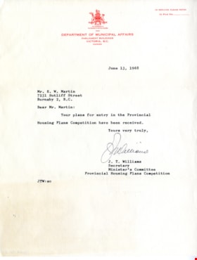
Letter re entry in Provincial Housing Plans Competition
https://search.heritageburnaby.ca/link/museumdescription15073
- Repository
- Burnaby Village Museum
- Date
- 13 Jun. 1968
- Collection/Fonds
- Elmer Wilson Martin fonds
- Description Level
- Item
- Physical Description
- 1 p.
- Scope and Content
- Item consists of a letter addressed to Mr. E.W. Martin from the Department of Municipal Affairs, Parliament Buildings, Victoria B.C. regarding his receipt of entry in the Provincial Housing Plans Competition.
- Repository
- Burnaby Village Museum
- Collection/Fonds
- Elmer Wilson Martin fonds
- Description Level
- Item
- Physical Description
- 1 p.
- Scope and Content
- Item consists of a letter addressed to Mr. E.W. Martin from the Department of Municipal Affairs, Parliament Buildings, Victoria B.C. regarding his receipt of entry in the Provincial Housing Plans Competition.
- Names
- Martin, Elmer Wilson
- Accession Code
- BV019.40.5
- Access Restriction
- No restrictions
- Reproduction Restriction
- May be restricted by third party rights
- Date
- 13 Jun. 1968
- Media Type
- Textual Record
- Scan Resolution
- 600
- Scan Date
- February 4, 2021
- Scale
- 100
- Notes
- Title based on contents of item
Images


New Vista Society housing
https://search.heritageburnaby.ca/link/archivedescription35646
- Repository
- City of Burnaby Archives
- Date
- 1956 (date of original), copied 1986
- Collection/Fonds
- Burnaby Historical Society fonds
- Description Level
- Item
- Physical Description
- 1 photograph : b&w ; 12.7 x 17.8 cm print
- Scope and Content
- Photograph of New Vista Society duplex housing, 7201 Mary Avenue at Rosewood Street, East Burnaby. Ernie Winch (father) and Harold Winch (son) were instrumental in the founding of the New Vista Society.
- Repository
- City of Burnaby Archives
- Date
- 1956 (date of original), copied 1986
- Collection/Fonds
- Burnaby Historical Society fonds
- Subseries
- Pioneer Tales subseries
- Physical Description
- 1 photograph : b&w ; 12.7 x 17.8 cm print
- Description Level
- Item
- Record No.
- 204-504
- Access Restriction
- No restrictions
- Reproduction Restriction
- Reproduce for fair dealing purposes only
- Accession Number
- BHS1988-03
- Scope and Content
- Photograph of New Vista Society duplex housing, 7201 Mary Avenue at Rosewood Street, East Burnaby. Ernie Winch (father) and Harold Winch (son) were instrumental in the founding of the New Vista Society.
- Subjects
- Buildings - Residential
- Media Type
- Photograph
- Notes
- Title based on contents of photograph
- Geographic Access
- Mary Avenue
- Street Address
- 7201 Mary Avenue
- Historic Neighbourhood
- East Burnaby (Historic Neighbourhood)
- Planning Study Area
- Richmond Park Area
Images

![New Vista Society Housing Projects, [between 1949 and 1957] thumbnail](/media/hpo/_Data/_Archives_Images/_Unrestricted/513/514-013.jpg?width=280)
New Vista Society Housing Projects
https://search.heritageburnaby.ca/link/archivedescription64687
- Repository
- City of Burnaby Archives
- Date
- [between 1949 and 1957]
- Collection/Fonds
- Ernest Winch fonds
- Description Level
- Item
- Physical Description
- 1 photograph : b&w postcard ; 8 x 13 cm
- Scope and Content
- Photographic postcard of an unpaved road lined with New Vista Society Housing Projects.
- Repository
- City of Burnaby Archives
- Date
- [between 1949 and 1957]
- Collection/Fonds
- Ernest Winch fonds
- Physical Description
- 1 photograph : b&w postcard ; 8 x 13 cm
- Description Level
- Item
- Record No.
- 514-013
- Access Restriction
- No restrictions
- Reproduction Restriction
- May be restricted by third party rights
- Accession Number
- 2010-06
- Scope and Content
- Photographic postcard of an unpaved road lined with New Vista Society Housing Projects.
- Names
- New Vista Society
- Media Type
- Photograph
- Notes
- Title based on contents of photograph
- Handwritten in border of photograph: "1-2-3"
Images
![New Vista Society Housing Projects, [between 1949 and 1957] thumbnail](/media/hpo/_Data/_Archives_Images/_Unrestricted/513/514-013.jpg)
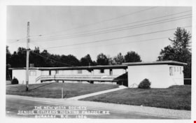
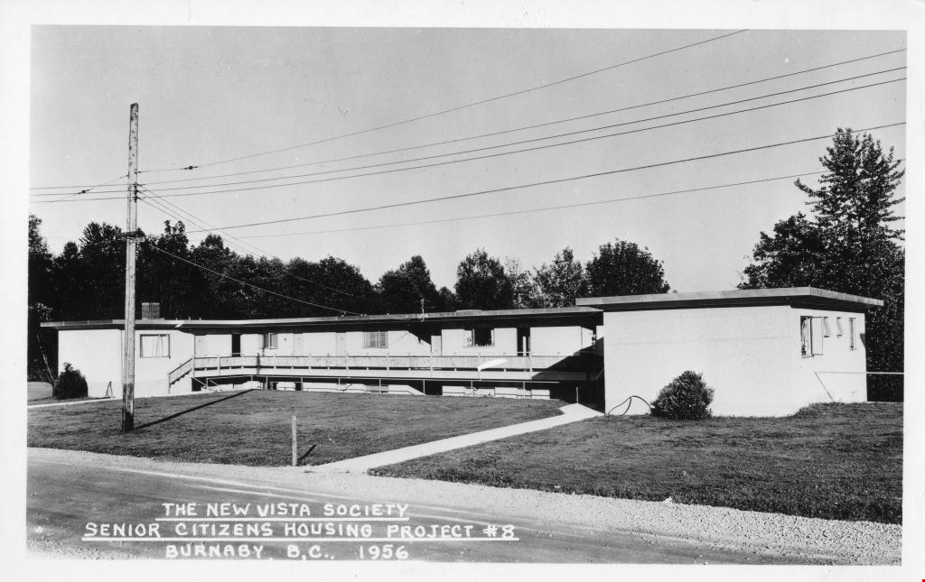
The New Vista Society Senior Citizens Housing Project
https://search.heritageburnaby.ca/link/archivedescription64678
- Repository
- City of Burnaby Archives
- Date
- 1956
- Collection/Fonds
- Ernest Winch fonds
- Description Level
- Item
- Physical Description
- 1 photograph : b&w postcard ; 8 x 13 cm
- Scope and Content
- Photographic postcard of New Vista Society Senior Citizens Housing Project no. 8 in East Burnaby.
- Repository
- City of Burnaby Archives
- Date
- 1956
- Collection/Fonds
- Ernest Winch fonds
- Physical Description
- 1 photograph : b&w postcard ; 8 x 13 cm
- Description Level
- Item
- Record No.
- 514-011
- Access Restriction
- No restrictions
- Reproduction Restriction
- Reproduce for fair dealing purposes only
- Accession Number
- 2010-06
- Scope and Content
- Photographic postcard of New Vista Society Senior Citizens Housing Project no. 8 in East Burnaby.
- Names
- New Vista Society
- Media Type
- Photograph
- Notes
- Transcribed title
- Photographer's note on recto of photograph reads: "The New Vista Society / Senior Citizens Housing Project # 8 / Burnaby, B.C., 1956"
- Historic Neighbourhood
- East Burnaby (Historic Neighbourhood)
Images

Norman Bethune Housing Cooperative
https://search.heritageburnaby.ca/link/archivedescription56667
- Repository
- City of Burnaby Archives
- Date
- November 1976
- Collection/Fonds
- Columbian Newspaper collection
- Description Level
- Item
- Physical Description
- 1 photograph : b&w ; 15 x 19.5 cm
- Scope and Content
- Photograph of Larry Whaley, then president of the Norman Bethune Housing Cooperative, standing outside the housing complex where he lived. At the time, only 24 units were inhabited by members while the other 282 units that were supposed to be opened up in the second stage of the project were vacant…
- Repository
- City of Burnaby Archives
- Date
- November 1976
- Collection/Fonds
- Columbian Newspaper collection
- Physical Description
- 1 photograph : b&w ; 15 x 19.5 cm
- Description Level
- Item
- Record No.
- 480-1253
- Access Restriction
- No restrictions
- Reproduction Restriction
- No restrictions
- Accession Number
- 2003-02
- Scope and Content
- Photograph of Larry Whaley, then president of the Norman Bethune Housing Cooperative, standing outside the housing complex where he lived. At the time, only 24 units were inhabited by members while the other 282 units that were supposed to be opened up in the second stage of the project were vacant due to a misunderstanding between the provincial and federal governments, and the allocation of nine million dollars that had been sent aside in 1973 for for rental housing in Burnaby.
- Names
- Whaley, Larry
- Media Type
- Photograph
- Photographer
- King, Basil
- Notes
- Title based on contents of photograph
- Newspaper clipping attached to verso of photograph reads: "Larry Whaley ponders what will happen to Bethune Co-Op Housing in Simon Fraser Hills area."
- Geographic Access
- Centaurus Circle
- Street Address
- 8752 Centaurus Circle
- Historic Neighbourhood
- Burquitlam (Historic Neighbourhood)
- Planning Study Area
- Lyndhurst Area
Images

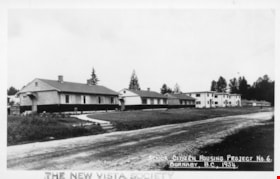
Senior Citizen Housing Project # 6
https://search.heritageburnaby.ca/link/archivedescription64660
- Repository
- City of Burnaby Archives
- Date
- 1954
- Collection/Fonds
- Ernest Winch fonds
- Description Level
- Item
- Physical Description
- 1 photograph : b&w postcard ; 8 x 13 cm
- Scope and Content
- Photographic postcard of New Vista Society's Senior Citizen Housing Project no. 6 on 11th Avenue in Burnaby.
- Repository
- City of Burnaby Archives
- Date
- 1954
- Collection/Fonds
- Ernest Winch fonds
- Physical Description
- 1 photograph : b&w postcard ; 8 x 13 cm
- Description Level
- Item
- Record No.
- 514-009
- Access Restriction
- No restrictions
- Reproduction Restriction
- Reproduce for fair dealing purposes only
- Accession Number
- 2010-06
- Scope and Content
- Photographic postcard of New Vista Society's Senior Citizen Housing Project no. 6 on 11th Avenue in Burnaby.
- Names
- New Vista Society
- Media Type
- Photograph
- Notes
- Transcribed title
- Photographer's note on recto of photograph reads: "Senior Citizen Housing Project # 6 / Burnaby, B.C., 1954"
- Stamp at border of photograph reads: "THE NEW VISTA SOCIETY"
- Geographic Access
- 11th Avenue
- Historic Neighbourhood
- East Burnaby (Historic Neighbourhood)
- Planning Study Area
- Second Street Area
Images

![SFU housing, [2001] thumbnail](/media/hpo/_Data/_Archives_Images/_Unrestricted/535/535-1647-1.jpg?width=280)
SFU housing
https://search.heritageburnaby.ca/link/archivedescription95824
- Repository
- City of Burnaby Archives
- Date
- [2001]
- Collection/Fonds
- Burnaby NewsLeader photograph collection
- Description Level
- File
- Physical Description
- 2 photographs (tiff) : col.
- Scope and Content
- File contains photographs of Ryan Stewart posed at Simon Fraser University. He sits on the lawn in front of the main entrance to Simon Fraser University and on a tree-lined road.
- Repository
- City of Burnaby Archives
- Date
- [2001]
- Collection/Fonds
- Burnaby NewsLeader photograph collection
- Physical Description
- 2 photographs (tiff) : col.
- Description Level
- File
- Record No.
- 535-1647
- Access Restriction
- No restrictions
- Reproduction Restriction
- No restrictions
- Accession Number
- 2018-12
- Scope and Content
- File contains photographs of Ryan Stewart posed at Simon Fraser University. He sits on the lawn in front of the main entrance to Simon Fraser University and on a tree-lined road.
- Names
- Simon Fraser University
- Media Type
- Photograph
- Photographer
- Ponne, Simone
- Notes
- Title based on original file name
- Collected by editorial for use in a February 2001 issue of the Burnaby NewsLeader
- Caption from metadata: "Ryan Stewart."
- Geographic Access
- Burnaby Mountain Conservation Area
- University Drive
- Street Address
- 8888 University Drive
- Planning Study Area
- Burnaby Mountain Area
Images
![SFU housing, [2001] thumbnail](/media/hpo/_Data/_Archives_Images/_Unrestricted/535/535-1647-1.jpg)

Bell's Drygoods Store
https://search.heritageburnaby.ca/link/landmark537
- Repository
- Burnaby Heritage Planning
- Description
- Bell’s Drygoods Store is a typical commercial false front, single storey, wood-frame building that has been relocated to the Burnaby Village Museum.
- Associated Dates
- 1922
- Formal Recognition
- Heritage Designation, Community Heritage Register
- Other Names
- Whitechurch Hardware Store
- Repository
- Burnaby Heritage Planning
- Other Names
- Whitechurch Hardware Store
- Geographic Access
- Deer Lake Avenue
- Associated Dates
- 1922
- Formal Recognition
- Heritage Designation, Community Heritage Register
- Enactment Type
- Bylaw No. 9807
- Enactment Date
- 23/11/1992
- Description
- Bell’s Drygoods Store is a typical commercial false front, single storey, wood-frame building that has been relocated to the Burnaby Village Museum.
- Heritage Value
- The value of the Bell’s Drygoods Store lies in its significance as one of the last remaining intact false front retail structures of its time to survive in Burnaby. Additionally, it remains as one of East Burnaby’s few surviving early commercial buildings and is representative of other typical commercial structures of the period. Originally located on Sixth Street in East Burnaby, in a small commercial district that served residents located along the streetcar line between New Westminster and Edmonds, its proximity to the streetcar served to draw customers into the store. This store also served as the location of the East Burnaby Post Office, one of a number of local post offices located throughout the municipality during the early twentieth century. Clifford Tuckey constructed the building in 1922, with a small lean-to structure on the back housing a kitchen and bedroom. The store was sold soon afterwards to William and Flora Bell, who then lived and worked here for a number of years. It represents a traditional relationship of the owner’s home to the store during this period, indicating the modest means of the owners and their commitment to running the business. The building was later sold to Maurice and Mildred Whitechurch, who ran it for many years as a hardware store. In 1974, the structure was relocated to its present site at the Museum. The heritage value for this structure also lies in its interpretive value within the Burnaby Village Museum. The site is an important cultural feature for the interpretation of Burnaby’s heritage to the public. Between 1993 and 1996 the building was restored to its 1925 appearance.
- Defining Elements
- The character defining features of Bell’s Drygoods Store include its: - rectangular form and simple massing - commercial false front parapet - front gable roof with cedar shingle cladding - horizontal lapped wooden siding - recessed main central entrance flanked by large storefront display windows - V-joint tongue-and-groove wood interior paneling - interior separation between commercial and residential space
- Locality
- Deer Lake Park
- Historic Neighbourhood
- Burnaby Lake (Historic Neighbourhood)
- Planning Study Area
- Morley-Buckingham Area
- Organization
- Burnaby Village Museum
- Function
- Primary Current--Museum
- Primary Historic--Shop
- Community
- Burnaby
- Cadastral Identifier
- P.I.D. No. 011-030-356 Legal Description: Parcel 1, District Lot 79 and District Lot 85, Group 1, New Westminster District, Reference Plan 77594
- Boundaries
- Burnaby Village Museum is comprised of a single municipally-owned property located at 6501 Deer Lake Avenue, Burnaby.
- Area
- 38,488.63
- Contributing Resource
- Building
- Landscape Feature
- Structure
- Ownership
- Public (local)
- Documentation
- Heritage Site Files: PC77000 20. City of Burnaby Planning and Building Department, 4949 Canada Way, Burnaby, B.C., V5G 1M2
- Street Address
- 6501 Deer Lake Avenue
Images


Brantford Elementary School
https://search.heritageburnaby.ca/link/landmark809
- Repository
- Burnaby Heritage Planning
- Geographic Access
- Brantford Avenue
- Associated Dates
- 1965
- Heritage Value
- As housing developments extended north from Kingsway, pupil enrolments grew at Windsor and at Morley Schools so Brantford was built equidistant from the two to help ease enrolment problems. Brantford Elementary school opened in 1965 and was similar in structure to other schools built in Burnaby during this period - no basements, no second stories and no high stairways. Classrooms were built in a line and could easily be added to as enrolments increased. Brantford had room additions in 1969.
- Historic Neighbourhood
- Edmonds (Historic Neighbourhood)
- Planning Study Area
- Kingsway-Beresford Area
- Street Address
- 6512 Brantford Avenue
- Street View URL
- Google Maps Street View
Images


Brentwood Neighbourhood
https://search.heritageburnaby.ca/link/landmark780
- Repository
- Burnaby Heritage Planning
- Associated Dates
- 1955-2008
- Heritage Value
- Between 1955 and 2001, the Brentwood Neighbourhood developed into one of Burnaby's four official Town Centres. The Brentwood Town Centre serves the north-west sector of the Municipality, providing facilities such as commercial developments - of which the Brentwood Mall is the most significant. Under Burnaby's Residential Development Framework adopted by Council in 1981, the Town Centre also incorporated a full range of multi-housing types and forms in close relationship with their commercial facilities. In 1996, the City adopted the Brentwood Town Centre Development Plant to solidify the area as a focus of higher-density and higher-intensity residential and commercial opportunities, public transit and supporting leisure facilities.
- Planning Study Area
- Brentwood Area
Images


Brentwood Park Elementary School
https://search.heritageburnaby.ca/link/landmark679
- Repository
- Burnaby Heritage Planning
- Geographic Access
- Delta Avenue
- Associated Dates
- 1954
- Heritage Value
- Brentwood Park Elementary School was built during the post-World War Two housing boom in Burnaby and like other schools at the time, was similar in design - no basements, no second stories and no high stairways. New classrooms could be added in line with the original structure as was the case when two additions were put on between 1956 and 1958, a new classroom and library added in 1965-1966 and two more classrooms in 1969.
- Planning Study Area
- Brentwood Area
- Street Address
- 1455 Delta Avenue
- Street View URL
- Google Maps Street View
Images


Burnaby Mountain Neighbourhood
https://search.heritageburnaby.ca/link/landmark792
- Repository
- Burnaby Heritage Planning
- Associated Dates
- 1955-2008
- Heritage Value
- Burnaby Mountain had been dedicated as park in 1942, however the original park boundaries were reconsidered in 1952 with the development of the Trans Mountain Pipeline. Although the boundaries were adjusted to accommodate this project, significant conservation and park lands were left untouched. When, in 1962, the government of British Columbia determined the need for additional post-secondary facilities, Burnaby Mountain was chosen as the site for the new Simon Fraser University which opened in 1965. As early as 1964, the idea of establishing a townsite around the university had been discussed by Burnaby, but it was not until the mid-1990s that the idea came to fruition and by the early 2000s, a new housing development know as the UniverCity took shape on the mountain adjacent to the university.
- Historic Neighbourhood
- Barnet (Historic Neighbourhood)
- Planning Study Area
- Burnaby Mountain Area
Images


Cameron Elementary School
https://search.heritageburnaby.ca/link/landmark833
- Repository
- Burnaby Heritage Planning
- Geographic Access
- Erickson Drive
- Associated Dates
- 1965
- Heritage Value
- The increasing density of housing around the Lougheed Shopping Centre area resulted in a spike in enrolment at Lyndhurst Elementary School. As a result, in 1965, Cameron Road Elementary was built to alleviate overcrowding issues. The school opened with 151 pupils. The school was expanded in 1969 when three classrooms were added and again in 1971 when eights more rooms and a library were built.
- Historic Neighbourhood
- Burquitlam (Historic Neighbourhood)
- Planning Study Area
- Cameron Area
- Street Address
- 9540 Erickson Drive
- Street View URL
- Google Maps Street View
Images
