Narrow Results By
Subject
- Agriculture - Farms 1
- Agriculture - Fruit and Berries 1
- Animals - Cats 1
- Animals - Cows 1
- Animals - Dogs 1
- Buildings - Civic - City Halls 1
- Buildings - Military 1
- Buildings - Residential - Houses 2
- Clothing - Military Uniforms 5
- Documentary Artifacts - Portraits 1
- Events - Anniversaries 1
- First Nations reserves - British Columbia 1
![Claude and Kitty, [between 1892 and 1914] thumbnail](/media/hpo/_Data/_Archives_Images/_Unrestricted/477/477-897.jpg?width=280)
Claude and Kitty
https://search.heritageburnaby.ca/link/archivedescription39578
- Repository
- City of Burnaby Archives
- Date
- [between 1892 and 1914]
- Collection/Fonds
- Peers Family and Hill Family fonds
- Description Level
- Item
- Physical Description
- 1 photograph : sepia ; 5.5 x 8 cm on page 21.5 x 28 cm (pasted in album)
- Scope and Content
- Photograph of a man in a hat and a young child riding in a horse-drawn carriage; possibly Mr. L.C. Hill and Kitty Hill being pulled by Kitty's horse Tom.
- Repository
- City of Burnaby Archives
- Date
- [between 1892 and 1914]
- Collection/Fonds
- Peers Family and Hill Family fonds
- Physical Description
- 1 photograph : sepia ; 5.5 x 8 cm on page 21.5 x 28 cm (pasted in album)
- Description Level
- Item
- Record No.
- 477-897
- Access Restriction
- No restrictions
- Reproduction Restriction
- No known restrictions
- Accession Number
- 2007-12
- Scope and Content
- Photograph of a man in a hat and a young child riding in a horse-drawn carriage; possibly Mr. L.C. Hill and Kitty Hill being pulled by Kitty's horse Tom.
- Media Type
- Photograph
- Notes
- Title based on contents of photograph
- Geographic Access
- Deer Lake Avenue
- Street Address
- 6501 Deer Lake Avenue
- Historic Neighbourhood
- Burnaby Lake (Historic Neighbourhood)
- Planning Study Area
- Morley-Buckingham Area
Images
![Claude and Kitty, [between 1892 and 1914] thumbnail](/media/hpo/_Data/_Archives_Images/_Unrestricted/477/477-897.jpg)
![Survey and Subdivision plans in New Westminster District Group 1 and Group 2 – Vancouver, ʷməθkʷəy̓əm (Musqueam) Indian Reserve, Burnaby, Surrey
, [1910-1911] thumbnail](/media/hpo/_Data/_BVM_Cartographic_Material/1977/1977_0093_0017_001.jpg?width=280)
Survey and Subdivision plans in New Westminster District Group 1 and Group 2 – Vancouver, ʷməθkʷəy̓əm (Musqueam) Indian Reserve, Burnaby, Surrey
https://search.heritageburnaby.ca/link/museumdescription6986
- Repository
- Burnaby Village Museum
- Date
- [1910-1911]
- Collection/Fonds
- Burnaby Village Museum Map collection
- Description Level
- File
- Physical Description
- 9 plans : 4 plans : blueprint ink on paper + 4 plans : black ink on paper + 1 plan : graphite on paper mounted on 2 sides of cardboard 76 x 102 cm
- Scope and Content
- File consists of a large board of three survey plans in New Westminster District Group 1 mounted on one side and six survey and subdivision plans of District Lot 85, New Westminster District Group 1 mounted on the other side. Side A: 1. Plan : blueprint on paper ; 30.5 x 80 cm. Title reads: "Fras…
- Repository
- Burnaby Village Museum
- Collection/Fonds
- Burnaby Village Museum Map collection
- Description Level
- File
- Physical Description
- 9 plans : 4 plans : blueprint ink on paper + 4 plans : black ink on paper + 1 plan : graphite on paper mounted on 2 sides of cardboard 76 x 102 cm
- Material Details
- Scales vary (One chain equals 792 inches)
- Indexed number on tape on edge of board reads "17"
- Scope and Content
- File consists of a large board of three survey plans in New Westminster District Group 1 mounted on one side and six survey and subdivision plans of District Lot 85, New Westminster District Group 1 mounted on the other side. Side A: 1. Plan : blueprint on paper ; 30.5 x 80 cm. Title reads: "Fraser River Bridge / Plan of South Approach". Plan covers area of land north of the Fraser River and Great Northern Railway with approach for a bridge running through the "ʷməθkʷəy̓əm (Musqueam) Indian Reserve" (ʷməθkʷəy̓əm (Musqueam) First Nation) and lots marked as Dominion Government and the east half of Lot 2 identified as "C. F. Brown" "Plan 851". Plan is identified as "Plan 851 / traced / Mar. 17, 1911". (Geographic location in Vancouver) Scale: 100 feet = 1 inch, Signed by Albert J. Hill / P.L.S." 2. Plan : blueprint on paper ; 36.5 x 35 cm (no title). Includes three plans of lots on the east and west sides of North Road. Note on bottom of blueprint reads: "I.E.B. McKay Surveyor General - hereby certify / that this is a correct tracing from the field / notes of the Royal Engineers on file in the / Lands Department / E.B. McKay (signature) / Surveyor General / Victoria B.C. April 11th 1911" . Plan in top left titled "Page 11 / Vol. 1. / R.E. Notes" covers District Lots east of North Road including Lot 5, Lot 7, Lot 41, Lot 9 and Lot 107 in Coquitlam. Plan in top right corner titled "Page 17 / Vol. 1. / R.E. Notes" covers District Lots east of North Road including Lot 104, Lot 54, Lot 105, Lot 55, Lot 106, Lot 9 and Lot 107 in Coquitlam and Port Moody. Plan in lower left corner titled "Page 15 / Vol. 1 / R.E. Notes" covers District Lots west of North Road including Lot 147, Lot 148, Lot 100, Lot 15 in Burnaby. 3. Plan : blue print on paper ; 29.5 x 41.5 cm. (no formal title). Plan of the North 1/2 of Section 18. Plan covers area in the "North 1/2 of Sec.18 B.5 N RGE 1 W" and "Sec. 18 B.5 N. RGE 1 W" bordered by Section 7, Section 13, Section 17 and Section 19. Bon Accord Road runs through Sec. 18. The plan is signed by surveryor "I.H. Neville Smith... C.E.B.C.L.S. / Mar. 26th 1910" and signed by "Ludwig Pillath". (Geographic location: Surrey) Side B: 1. Plan : blueprint on paper ; 43.5 x 49.5 cm. Title reads: "Plan / of Subdivision / of a Portion / of / Lot 85 / Group One / New Westminster District. Plan covers portion of land east of Deer Lake and Pole Line Road (Sperling Avenue) and south of Hastings Road in District Lot 85 in Burnaby with section 4 and a portion of section 2 coloured in red. Plan is signed by "Albert J. Hill, B.C.L.S." Plan is initialed by: "RB" [sic] (in blue pencil crayon) Scale: 4 chains = 1 inch 2. Plaln : black black ink on linen ; 39 x 37 cm. Title reads: "L.C. Hill's Property, / Burnaby". Plan covers a triangular portion of land east of Pole Line Road (Sperling Avenue) and south of Hastings Road in District Lot 85 in Burnaby. Plan is intitaled by "RB" [sic] (in blue pencil crayon). Scale: 3 chains = 1 mile 3. Plan : graphite on paper ; 23 x 17 cm. Title reads: "Portion of Lot 85 / Gr.1". Plan covers portion of land north east of Deer Lake and west of Pole Line Road (now Sperling Avenue) in District Lot 85 in Burnaby. Plan is stamped in red ink: "Albert J. Hill, Civil Engineer". Plan is initialed by: "RB" [sic] (in blue pencil crayon). Scale: 1 chain = 1 inch 4. Plan : black ink on linen ; 16 x 19 cm. Title reads: "Lot 85". Plan covers the intersection of Pole Line Road (Sperling Avenue) and Hastings Road at the north west section of District Lot 79 and District Lot 85 in Burnaby. Plan is stamped: "A.J. Hill, Civil Engineer" with identitifed in blue pencil crayon. 5. Plan : black ink on paper ; 28.5 x 37 cm. (no formal title) Plan covers an area of land, west of Pole Line Road (Sperling Avenue) and south of Deer Lake in District Lot 85 in Burnaby. Plan is initialed by: "RB" [sic] (in blue pencil crayon) 6. Plan : black ink on paper ; 21 x 34 cm (no formal title). Plan covers an area of land, west of Pole Line Road (Sperling Avenue) and south of Deer Lake in District Lot 85 in Burnaby. Plan is initialed by: "RB" [sic] (in blue pencil crayon)
- Accession Code
- HV977.93.17
- Access Restriction
- No restrictions
- Reproduction Restriction
- No known restrictions
- Date
- [1910-1911]
- Media Type
- Cartographic Material
- Historic Neighbourhood
- Burnaby Lake (Historic Neighbourhood)
- Burquitlam (Historic Neighbourhood)
- Planning Study Area
- Morley-Buckingham Area
- Douglas-Gilpin Area
- Scan Resolution
- 600
- Scan Date
- 2023-06-26
- Notes
- Title based on contents of file
- Scale is measured in chains and feet. (One chain equals 792 inches).
- The term "Lot" also refers to a "District Lot”
- Some plans are stamped: "Albert J. Hill, Civil Engineer / and / Provincial Land Surveyor, / New Westminster, / B.C." and intialed: "RB" [sic]
Zoomable Images
![Survey and Subdivision plans in New Westminster District Group 1 and Group 2 – Vancouver, ʷməθkʷəy̓əm (Musqueam) Indian Reserve, Burnaby, Surrey
, [1910-1911] thumbnail](/media/hpo/_Data/_BVM_Cartographic_Material/1977/1977_0093_0017_003_seadragon/1977_0093_0017_003.jpg?w=280)
Survey and Subdivision plans in New Westminster District Group 1 and Group 2 – Vancouver, ʷməθkʷəy̓əm (Musqueam) Indian Reserve, Burnaby, Surrey , [1910-1911]
Zoom into Image
![Municipal Council in front of the Municipal Hall, [1910] thumbnail](/media/hpo/_Data/_BVM_Images/1971/197300400003.jpg?width=280)
Municipal Council in front of the Municipal Hall
https://search.heritageburnaby.ca/link/museumdescription990
- Repository
- Burnaby Village Museum
- Date
- [1910]
- Collection/Fonds
- Burnaby Village Museum Photograph collection
- Description Level
- Item
- Physical Description
- 1 photograph : sepia ; 19.5 x 24.5 cm, mounted on card 35 x 37.5 cm
- Scope and Content
- Photograph of the Municipal Council and members of the municipal hall staff sitting and standing in two rows outside the enlarged version of Burnaby's first Municipal Hall. Identified, seated (from left): L. Claude Hill, T.D. Coldicutt, J. Love, Reeve Peter Byrne, Duncan C. McGregor, John Rumble an…
- Repository
- Burnaby Village Museum
- Collection/Fonds
- Burnaby Village Museum Photograph collection
- Description Level
- Item
- Physical Description
- 1 photograph : sepia ; 19.5 x 24.5 cm, mounted on card 35 x 37.5 cm
- Scope and Content
- Photograph of the Municipal Council and members of the municipal hall staff sitting and standing in two rows outside the enlarged version of Burnaby's first Municipal Hall. Identified, seated (from left): L. Claude Hill, T.D. Coldicutt, J. Love, Reeve Peter Byrne, Duncan C. McGregor, John Rumble and Eber Stride. Behind, standing, fifth from the left is F.L. MacPherson.
- Names
- Byrne, Peter
- Hill, Louis Claude "Claude"
- Coldicutt, Thomas D.
- Love, Jesse, 1849-1928
- McGregor, Duncan C., 1853-1929
- Rumble, John
- Stride, Eber
- MacPherson, Frederick L. "Fred"
- Burnaby City Hall
- Geographic Access
- Kingsway
- Street Address
- 7282 Kingsway
- Accession Code
- HV973.40.3
- Access Restriction
- No restrictions
- Reproduction Restriction
- No known restrictions
- Date
- [1910]
- Media Type
- Photograph
- Historic Neighbourhood
- Edmonds (Historic Neighbourhood)
- Planning Study Area
- Stride Avenue Area
- Related Material
- According to earlier catalogue record, a plan for the conversion from the municipal hall to a community hall is in the the BVM archives.
- Scan Resolution
- 600
- Scan Date
- 1/8/2010
- Scale
- 100
- Photographer
- Broadbridge Commercial Photo Company
- Notes
- Title based on contents of photograph
- Note on verso of original reads: "Burnaby Municipal Council in front of the first Municipal Hall on Kingsway"
- Stamp on verso of photograph reads: "The Broadbridge Commercial Photo Co. / 530 Homer St. Vancouver [illegible]"
Images
![Municipal Council in front of the Municipal Hall, [1910] thumbnail](/media/hpo/_Data/_BVM_Images/1971/197300400003.jpg)
![L. Claude and Kitty Hill boating, [1910] thumbnail](/media/hpo/_Data/_Archives_Images/_Unrestricted/477/477-070.jpg?width=280)
L. Claude and Kitty Hill boating
https://search.heritageburnaby.ca/link/archivedescription38751
- Repository
- City of Burnaby Archives
- Date
- [1910]
- Collection/Fonds
- Peers Family and Hill Family fonds
- Description Level
- Item
- Physical Description
- 1 photograph : b&w ; 8 x 10 cm on page 11.5 x 14 cm (pasted in album)
- Scope and Content
- Photograph of L. Claude Hill and his daughter Kitty (centre) with Florence Hart boating on lake.
- Repository
- City of Burnaby Archives
- Date
- [1910]
- Collection/Fonds
- Peers Family and Hill Family fonds
- Physical Description
- 1 photograph : b&w ; 8 x 10 cm on page 11.5 x 14 cm (pasted in album)
- Description Level
- Item
- Record No.
- 477-070
- Access Restriction
- No restrictions
- Reproduction Restriction
- No known restrictions
- Accession Number
- 2007-12
- Scope and Content
- Photograph of L. Claude Hill and his daughter Kitty (centre) with Florence Hart boating on lake.
- Media Type
- Photograph
- Notes
- Title based on contents of photograph
Images
![L. Claude and Kitty Hill boating, [1910] thumbnail](/media/hpo/_Data/_Archives_Images/_Unrestricted/477/477-070.jpg)
![Strawberry crates, [1910] thumbnail](/media/hpo/_Data/_Archives_Images/_Unrestricted/477/477-073.jpg?width=280)
Strawberry crates
https://search.heritageburnaby.ca/link/archivedescription38754
- Repository
- City of Burnaby Archives
- Date
- [1910]
- Collection/Fonds
- Peers Family and Hill Family fonds
- Description Level
- Item
- Physical Description
- 1 photograph : b&w ; 6 x 10 cm on page 11.5 x 14 cm (pasted in album)
- Scope and Content
- Photograph of two berry crates, one stamped "L. Claude Hill Burnaby Lake Fruit Growers Association" and the other stamped "S. Claude Hill Burnaby Lake Fruit Growers Association."
- Repository
- City of Burnaby Archives
- Date
- [1910]
- Collection/Fonds
- Peers Family and Hill Family fonds
- Physical Description
- 1 photograph : b&w ; 6 x 10 cm on page 11.5 x 14 cm (pasted in album)
- Description Level
- Item
- Record No.
- 477-073
- Access Restriction
- No restrictions
- Reproduction Restriction
- No known restrictions
- Accession Number
- 2007-12
- Scope and Content
- Photograph of two berry crates, one stamped "L. Claude Hill Burnaby Lake Fruit Growers Association" and the other stamped "S. Claude Hill Burnaby Lake Fruit Growers Association."
- Subjects
- Agriculture - Fruit and Berries
- Media Type
- Photograph
- Notes
- Title based on contents of photograph
Images
![Strawberry crates, [1910] thumbnail](/media/hpo/_Data/_Archives_Images/_Unrestricted/477/477-073.jpg)
![Claude Hill leading a cow, [1910] thumbnail](/media/hpo/_Data/_Archives_Images/_Unrestricted/477/477-075.jpg?width=280)
Claude Hill leading a cow
https://search.heritageburnaby.ca/link/archivedescription38756
- Repository
- City of Burnaby Archives
- Date
- [1910]
- Collection/Fonds
- Peers Family and Hill Family fonds
- Description Level
- Item
- Physical Description
- 1 photograph : b&w ; 5 x 8 cm on page 11.5 x 14 cm (pasted in album)
- Scope and Content
- Photograph of Claude Hill leading a cow with a rope. The photograph was likely taken at the Hill family home, known as Broadview, on Buckingham Avenue.
- Repository
- City of Burnaby Archives
- Date
- [1910]
- Collection/Fonds
- Peers Family and Hill Family fonds
- Physical Description
- 1 photograph : b&w ; 5 x 8 cm on page 11.5 x 14 cm (pasted in album)
- Description Level
- Item
- Record No.
- 477-075
- Access Restriction
- No restrictions
- Reproduction Restriction
- No known restrictions
- Accession Number
- 2007-12
- Scope and Content
- Photograph of Claude Hill leading a cow with a rope. The photograph was likely taken at the Hill family home, known as Broadview, on Buckingham Avenue.
- Subjects
- Animals - Cows
- Occupations - Farmers
- Media Type
- Photograph
- Notes
- Title based on contents of photograph
- Geographic Access
- Buckingham Avenue
- Street Address
- 5730 Buckingham Avenue
- Historic Neighbourhood
- Burnaby Lake (Historic Neighbourhood)
- Planning Study Area
- Morley-Buckingham Area
Images
![Claude Hill leading a cow, [1910] thumbnail](/media/hpo/_Data/_Archives_Images/_Unrestricted/477/477-075.jpg)
![Group boarding a boat, [1910] thumbnail](/media/hpo/_Data/_Archives_Images/_Unrestricted/477/477-165.jpg?width=280)
Group boarding a boat
https://search.heritageburnaby.ca/link/archivedescription38846
- Repository
- City of Burnaby Archives
- Date
- [1910]
- Collection/Fonds
- Peers Family and Hill Family fonds
- Description Level
- Item
- Physical Description
- 1 photograph : b&w ; 7.5 x 10 cm on page 11.5 x 14 cm (pasted in album)
- Scope and Content
- Photograph of a group of people preparing to board a small boat at the end of a dock. Claude Hill is on the far left and his daughter Kitty Hill is standing next to the boat on the right (in white dress with hat). The others are unidentified.
- Repository
- City of Burnaby Archives
- Date
- [1910]
- Collection/Fonds
- Peers Family and Hill Family fonds
- Physical Description
- 1 photograph : b&w ; 7.5 x 10 cm on page 11.5 x 14 cm (pasted in album)
- Description Level
- Item
- Record No.
- 477-165
- Access Restriction
- No restrictions
- Reproduction Restriction
- No known restrictions
- Accession Number
- 2007-12
- Scope and Content
- Photograph of a group of people preparing to board a small boat at the end of a dock. Claude Hill is on the far left and his daughter Kitty Hill is standing next to the boat on the right (in white dress with hat). The others are unidentified.
- Subjects
- Transportation - Boats
- Media Type
- Photograph
- Notes
- Title based on contents of photograph
Images
![Group boarding a boat, [1910] thumbnail](/media/hpo/_Data/_Archives_Images/_Unrestricted/477/477-165.jpg)
![Claude Hill in uniform, [1910] thumbnail](/media/hpo/_Data/_Archives_Images/_Unrestricted/477/477-503.jpg?width=280)
Claude Hill in uniform
https://search.heritageburnaby.ca/link/archivedescription39184
- Repository
- City of Burnaby Archives
- Date
- [1910]
- Collection/Fonds
- Peers Family and Hill Family fonds
- Description Level
- Item
- Physical Description
- 1 photograph : b&w ; 1.5 x 2 cm cut to size on page 24.5 x 32.5 cm (pasted in album)
- Scope and Content
- Photograph of Claude Hill, in uniform. The photograph has been cut to shape around his outline and pasted on an album page with similar pictures collectively titled "Heads and Tales."
- Repository
- City of Burnaby Archives
- Date
- [1910]
- Collection/Fonds
- Peers Family and Hill Family fonds
- Physical Description
- 1 photograph : b&w ; 1.5 x 2 cm cut to size on page 24.5 x 32.5 cm (pasted in album)
- Description Level
- Item
- Record No.
- 477-503
- Access Restriction
- No restrictions
- Reproduction Restriction
- No known restrictions
- Accession Number
- 2007-12
- Scope and Content
- Photograph of Claude Hill, in uniform. The photograph has been cut to shape around his outline and pasted on an album page with similar pictures collectively titled "Heads and Tales."
- Media Type
- Photograph
- Notes
- Title based on contents of photograph
Images
![Claude Hill in uniform, [1910] thumbnail](/media/hpo/_Data/_Archives_Images/_Unrestricted/477/477-503.jpg)

Claude and Kitty on a footbridge
https://search.heritageburnaby.ca/link/archivedescription39558
- Repository
- City of Burnaby Archives
- Date
- 1910
- Collection/Fonds
- Peers Family and Hill Family fonds
- Description Level
- Item
- Physical Description
- 1 photograph : b&w ; 7.5 x 10 cm on page 21.5 x 28 cm (pasted in album)
- Scope and Content
- Photograph of Claude Hill with his daughter Kitty standing on a foot bridge over a small creek. In the background directly behind Kitty can be seen the Hill family home known as Broadview which was located on Buckingham Avenue. The Pole Line Road (later renamed Sperling Avenue) can also be seen. …
- Repository
- City of Burnaby Archives
- Date
- 1910
- Collection/Fonds
- Peers Family and Hill Family fonds
- Physical Description
- 1 photograph : b&w ; 7.5 x 10 cm on page 21.5 x 28 cm (pasted in album)
- Description Level
- Item
- Record No.
- 477-877
- Access Restriction
- No restrictions
- Reproduction Restriction
- No known restrictions
- Accession Number
- 2007-12
- Scope and Content
- Photograph of Claude Hill with his daughter Kitty standing on a foot bridge over a small creek. In the background directly behind Kitty can be seen the Hill family home known as Broadview which was located on Buckingham Avenue. The Pole Line Road (later renamed Sperling Avenue) can also be seen. At the far left, top corner of the photograph another house is visible. This was the home of Francis J. Peers, on what is now Rugby Avenue (5289 Rugby). This house was known as Greyfriars. Kitty Hill would later marry Bob Peers, son of Francis.
- Subjects
- Structures - Bridges
- Media Type
- Photograph
- Notes
- Title based on contents of photograph
- Geographic Access
- Buckingham Avenue
- Sperling Avenue
- Street Address
- 5730 Buckingham Avenue
- Historic Neighbourhood
- Burnaby Lake (Historic Neighbourhood)
- Planning Study Area
- Morley-Buckingham Area
Images


Clearing Land for Oakalla Prison Farm
https://search.heritageburnaby.ca/link/archivedescription39574
- Repository
- City of Burnaby Archives
- Date
- 1910
- Collection/Fonds
- Peers Family and Hill Family fonds
- Description Level
- Item
- Physical Description
- 1 photograph : b&w ; 7.7 x 10.3 cm on page 21.5 x 28 cm (pasted in album)
- Scope and Content
- Photograph of the Oakalla Prison Farm site being cleared in the Deer Lake area. Claude Hill is to the far right but the other man is unidentified.
- Repository
- City of Burnaby Archives
- Date
- 1910
- Collection/Fonds
- Peers Family and Hill Family fonds
- Physical Description
- 1 photograph : b&w ; 7.7 x 10.3 cm on page 21.5 x 28 cm (pasted in album)
- Description Level
- Item
- Record No.
- 477-893
- Access Restriction
- No restrictions
- Reproduction Restriction
- No known restrictions
- Accession Number
- 2007-12
- Scope and Content
- Photograph of the Oakalla Prison Farm site being cleared in the Deer Lake area. Claude Hill is to the far right but the other man is unidentified.
- Subjects
- Land Clearing
- Media Type
- Photograph
- Notes
- Title based on contents of photograph
- Geographic Access
- Oakmount Crescent
- Street Address
- 5220 Oakmount Crescent
- Historic Neighbourhood
- Burnaby Lake (Historic Neighbourhood)
- Planning Study Area
- Oakalla Area
Images


Camp at Oakalla Site
https://search.heritageburnaby.ca/link/archivedescription39575
- Repository
- City of Burnaby Archives
- Date
- 1910
- Collection/Fonds
- Peers Family and Hill Family fonds
- Description Level
- Item
- Physical Description
- 1 photograph : b&w ; 7.7 x 10.4 cm on page 21.5 x 28 cm (pasted in album)
- Scope and Content
- Photograph of the land clearing operation at the Oakalla Prison site in the Deer Lake area. Claude Hill is in the centre between two unidentified men. A line of clothes is hanging in the background.
- Repository
- City of Burnaby Archives
- Date
- 1910
- Collection/Fonds
- Peers Family and Hill Family fonds
- Physical Description
- 1 photograph : b&w ; 7.7 x 10.4 cm on page 21.5 x 28 cm (pasted in album)
- Description Level
- Item
- Record No.
- 477-894
- Access Restriction
- No restrictions
- Reproduction Restriction
- No known restrictions
- Accession Number
- 2007-12
- Scope and Content
- Photograph of the land clearing operation at the Oakalla Prison site in the Deer Lake area. Claude Hill is in the centre between two unidentified men. A line of clothes is hanging in the background.
- Subjects
- Land Clearing
- Media Type
- Photograph
- Notes
- Title based on contents of photograph
- Geographic Access
- Oakmount Crescent
- Street Address
- 5220 Oakmount Crescent
- Historic Neighbourhood
- Burnaby Lake (Historic Neighbourhood)
- Planning Study Area
- Oakalla Area
Images

![Official Opening, [between 1911 and 1917] thumbnail](/media/hpo/_Data/_Archives_Images/_Unrestricted/001/024-001.jpg?width=280)
Official Opening
https://search.heritageburnaby.ca/link/archivedescription34503
- Repository
- City of Burnaby Archives
- Date
- [between 1911 and 1917]
- Collection/Fonds
- Burnaby Historical Society fonds
- Description Level
- Item
- Physical Description
- 1 photograph : b&w ; 16 x 21 cm
- Scope and Content
- Photograph of Burnaby Municipal Council in front of Burnaby Municipal Hall. Identified, front row, seated left to right: Eber Stride (former Council member), Peter Byrne (former Council member), Charles Frederick Sprott (former Council member), Reeve Hugh M. Fraser, [unidentified man], and possibl…
- Repository
- City of Burnaby Archives
- Date
- [between 1911 and 1917]
- Collection/Fonds
- Burnaby Historical Society fonds
- Subseries
- Photographs subseries
- Physical Description
- 1 photograph : b&w ; 16 x 21 cm
- Description Level
- Item
- Record No.
- 024-001
- Access Restriction
- No restrictions
- Reproduction Restriction
- No known restrictions
- Accession Number
- BHS2007-04
- Scope and Content
- Photograph of Burnaby Municipal Council in front of Burnaby Municipal Hall. Identified, front row, seated left to right: Eber Stride (former Council member), Peter Byrne (former Council member), Charles Frederick Sprott (former Council member), Reeve Hugh M. Fraser, [unidentified man], and possibly John W. Weart (former Reeve). Back row, standing left to right from uniformed man in centre: possibly Thomas Sanderson (in uniform, former Reeve), [unidentified man], possiby John Murray (Council member), George J. Webb (Council member), John Mulgrew (Council member), possibly Jesse Love (former Council member), Phillip W. Fau Vel (Council member), and Arthur Lomas (Council member). Standing at left beside stage: possibly Louis Claude "Claude" Hill. Photograph may depict the official opening of the second Municipal Hall (1912) or the 25th anniversary of the incorporation of Burnaby (1917).
- Subjects
- Events - Anniversaries
- Officials - Alderman and Councillors
- Buildings - Civic - City Halls
- Symbols - Flags
- Names
- Byrne, Peter
- Fau Vel, Phillip W.
- Fraser, Hugh M.
- Hill, Louis Claude "Claude"
- Lomas, Arthur
- Love, Jesse, 1849-1928
- Mulgrew, John
- Murray, John
- Sanderson, Thomas F.
- Sprott, Charles Frederick
- Stride, Eber
- Weart, John W.
- Webb, George J.
- Burnaby City Hall
- Media Type
- Photograph
- Notes
- Transcribed title
- Title transcribed from photograph caption
- Note in blue ink on verso reads: "25th Anniversary / Council in front of 2nd Municipal Hall / 1911"
- Geographic Access
- Kingsway
- Street Address
- 7282 Kingsway
- Historic Neighbourhood
- Edmonds (Historic Neighbourhood)
- Planning Study Area
- Stride Avenue Area
Images
![Official Opening, [between 1911 and 1917] thumbnail](/media/hpo/_Data/_Archives_Images/_Unrestricted/001/024-001.jpg)
![Hill boys and friends, [1911] (date of original), copied 1986 thumbnail](/media/hpo/_Data/_Archives_Images/_Unrestricted/204/204-788.jpg?width=280)
Hill boys and friends
https://search.heritageburnaby.ca/link/archivedescription35928
- Repository
- City of Burnaby Archives
- Date
- [1911] (date of original), copied 1986
- Collection/Fonds
- Burnaby Historical Society fonds
- Description Level
- Item
- Physical Description
- 1 photograph : b&w ; 12.7 x 17.8 cm print
- Scope and Content
- Photograph of the Hill family boys and friends swimming in Deer Lake. Gerry Hill is seated cross-legged in front.
- Repository
- City of Burnaby Archives
- Date
- [1911] (date of original), copied 1986
- Collection/Fonds
- Burnaby Historical Society fonds
- Subseries
- Pioneer Tales subseries
- Physical Description
- 1 photograph : b&w ; 12.7 x 17.8 cm print
- Description Level
- Item
- Record No.
- 204-788
- Access Restriction
- No restrictions
- Reproduction Restriction
- No known restrictions
- Accession Number
- BHS1988-03
- Scope and Content
- Photograph of the Hill family boys and friends swimming in Deer Lake. Gerry Hill is seated cross-legged in front.
- Media Type
- Photograph
- Notes
- Title based on contents of photograph
- Geographic Access
- Deer Lake
- Deer Lake Avenue
- Historic Neighbourhood
- Burnaby Lake (Historic Neighbourhood)
- Planning Study Area
- Morley-Buckingham Area
Images
![Hill boys and friends, [1911] (date of original), copied 1986 thumbnail](/media/hpo/_Data/_Archives_Images/_Unrestricted/204/204-788.jpg)
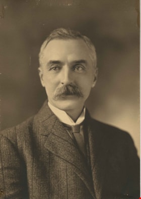
L. Claude Hill
https://search.heritageburnaby.ca/link/archivedescription38730
- Repository
- City of Burnaby Archives
- Date
- 1911
- Collection/Fonds
- Peers Family and Hill Family fonds
- Description Level
- Item
- Physical Description
- 1 photograph : sepia ; 10 x 14 cm
- Scope and Content
- Photograph is a studio portrait of Claude Hill, early Burnaby Lake resident.
- Repository
- City of Burnaby Archives
- Date
- 1911
- Collection/Fonds
- Peers Family and Hill Family fonds
- Physical Description
- 1 photograph : sepia ; 10 x 14 cm
- Description Level
- Item
- Record No.
- 477-049
- Access Restriction
- No restrictions
- Reproduction Restriction
- No known restrictions
- Accession Number
- 2007-12
- Scope and Content
- Photograph is a studio portrait of Claude Hill, early Burnaby Lake resident.
- Subjects
- Documentary Artifacts - Portraits
- Media Type
- Photograph
- Notes
- Title based on contents of photograph
Images


On Curtis Road, North Burnaby
https://search.heritageburnaby.ca/link/archivedescription38854
- Repository
- City of Burnaby Archives
- Date
- 1911
- Collection/Fonds
- Peers Family and Hill Family fonds
- Description Level
- Item
- Physical Description
- 1 photograph : b&w ; 6 x 10 cm on page 14 x 17.5 cm (pasted in album)
- Scope and Content
- Photograph of Claude Hill (right) and E.B. Wentenhall (left) standing on a bridge on Curtis Road in North Burnaby. Both men are holding walking sticks.
- Repository
- City of Burnaby Archives
- Date
- 1911
- Collection/Fonds
- Peers Family and Hill Family fonds
- Physical Description
- 1 photograph : b&w ; 6 x 10 cm on page 14 x 17.5 cm (pasted in album)
- Description Level
- Item
- Record No.
- 477-173
- Access Restriction
- No restrictions
- Reproduction Restriction
- No known restrictions
- Accession Number
- 2007-12
- Scope and Content
- Photograph of Claude Hill (right) and E.B. Wentenhall (left) standing on a bridge on Curtis Road in North Burnaby. Both men are holding walking sticks.
- Subjects
- Structures - Bridges
- Media Type
- Photograph
- Notes
- Title based on caption accompanying photograph
- Geographic Access
- Curtis Street
- Historic Neighbourhood
- Lochdale (Historic Neighbourhood)
- Planning Study Area
- Lochdale Area
Images


Tired Tim and Weary Willie
https://search.heritageburnaby.ca/link/archivedescription38855
- Repository
- City of Burnaby Archives
- Date
- 1911
- Collection/Fonds
- Peers Family and Hill Family fonds
- Description Level
- Item
- Physical Description
- 1 photograph : sepia ; 6 x 10 cm on page 14 x 17.5 cm (pasted in album)
- Scope and Content
- Photograph of Claude Hill (left) and E.B. Wentenhall (right) standing on fallen trees in the Curtis Road area of North Burnaby.
- Repository
- City of Burnaby Archives
- Date
- 1911
- Collection/Fonds
- Peers Family and Hill Family fonds
- Physical Description
- 1 photograph : sepia ; 6 x 10 cm on page 14 x 17.5 cm (pasted in album)
- Description Level
- Item
- Record No.
- 477-174
- Access Restriction
- No restrictions
- Reproduction Restriction
- No known restrictions
- Accession Number
- 2007-12
- Scope and Content
- Photograph of Claude Hill (left) and E.B. Wentenhall (right) standing on fallen trees in the Curtis Road area of North Burnaby.
- Subjects
- Land Clearing
- Plants - Trees
- Media Type
- Photograph
- Notes
- Title based on caption accompanying photograph
- Geographic Access
- Curtis Street
- Historic Neighbourhood
- Lochdale (Historic Neighbourhood)
- Planning Study Area
- Lochdale Area
Images

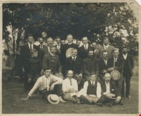
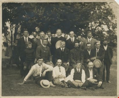
Burnaby Lake residents
https://search.heritageburnaby.ca/link/archivedescription34058
- Repository
- City of Burnaby Archives
- Date
- 1912
- Collection/Fonds
- Burnaby Historical Society fonds
- Description Level
- Item
- Physical Description
- 1 photograph : b&w ; 9.5 x 11.6 cm
- Scope and Content
- Photograph of a group of male Burnaby Lake residents posed outside near Deer Lake Drive. Identified, standing: B.R. Hill (3rd from left), Rev. D. Dunlop (6th from left), Harry Ramsay (8th from left), Louis "Edgar" Sprott (9th from left), and George Every-Clayton (10th from left). Sitting on bench…
- Repository
- City of Burnaby Archives
- Date
- 1912
- Collection/Fonds
- Burnaby Historical Society fonds
- Subseries
- Photographs subseries
- Physical Description
- 1 photograph : b&w ; 9.5 x 11.6 cm
- Description Level
- Item
- Record No.
- 003-001
- Access Restriction
- No restrictions
- Reproduction Restriction
- No known restrictions
- Accession Number
- BHS2007-04
- Scope and Content
- Photograph of a group of male Burnaby Lake residents posed outside near Deer Lake Drive. Identified, standing: B.R. Hill (3rd from left), Rev. D. Dunlop (6th from left), Harry Ramsay (8th from left), Louis "Edgar" Sprott (9th from left), and George Every-Clayton (10th from left). Sitting on bench: [first name unknown] Clayton (1st from left), Robert Pontifex (2nd from left), Mr. Clay (4th from left), and Frank Hill (6th from left). Sitting on ground: Claude Hill (1st from left) and Percy Boyer Brown (2nd from left).
- Names
- Brown, Percy Boyer
- Every-Clayton, George
- Dunlop, Rev. D.
- Hill, Bernard R.
- Hill, Frank
- Brown, Alex
- Hill, Louis Claude "Claude"
- Pontifex, Robert
- Ramsay, Harry
- Sprott, Louis "Edgar"
- Media Type
- Photograph
- Notes
- Title based on contents of photograph
- Identification key accompanying in the envelope for photo 003-001 (labeled BHS 3.1)
- Geographic Access
- Deer Lake
- Deer Lake Avenue
- Historic Neighbourhood
- Vancouver Heights (Historic Neighbourhood)
- Burnaby Lake (Historic Neighbourhood)
- Planning Study Area
- Douglas-Gilpin Area
Images
![Picnic at Fairacres, [1913] thumbnail](/media/hpo/_Data/_Archives_Images/_Unrestricted/205/241-019.jpg?width=280)
Picnic at Fairacres
https://search.heritageburnaby.ca/link/archivedescription36241
- Repository
- City of Burnaby Archives
- Date
- [1913]
- Collection/Fonds
- Burnaby Historical Society fonds
- Description Level
- Item
- Physical Description
- 1 photograph : b&w copy negative ; 5 x 8 cm
- Scope and Content
- Photograph of a picnic at Fairacres. The family is sitting and standing around a small wooden table, and their dog is lying on a blanket in front. Henry and Grace Ceperley (wearing a cardigan) are seated second and third from the left respectively and the couple seated next to them appears to the …
- Repository
- City of Burnaby Archives
- Date
- [1913]
- Collection/Fonds
- Burnaby Historical Society fonds
- Subseries
- Burnaby Art Gallery subseries
- Physical Description
- 1 photograph : b&w copy negative ; 5 x 8 cm
- Description Level
- Item
- Record No.
- 241-019
- Access Restriction
- No restrictions
- Reproduction Restriction
- No known restrictions
- Accession Number
- BHS1990-05
- Scope and Content
- Photograph of a picnic at Fairacres. The family is sitting and standing around a small wooden table, and their dog is lying on a blanket in front. Henry and Grace Ceperley (wearing a cardigan) are seated second and third from the left respectively and the couple seated next to them appears to the Claude Hill and his wife Annie.
- Media Type
- Photograph
- Notes
- Title based on contents of photograph 1 b&w copy print accompanying
- Geographic Access
- Deer Lake Avenue
- Street Address
- 6344 Deer Lake Avenue
- Historic Neighbourhood
- Burnaby Lake (Historic Neighbourhood)
- Planning Study Area
- Douglas-Gilpin Area
Images
![Picnic at Fairacres, [1913] thumbnail](/media/hpo/_Data/_Archives_Images/_Unrestricted/205/241-019.jpg)
![Rowing on Deer Lake, [1914] thumbnail](/media/hpo/_Data/_Archives_Images/_Unrestricted/477/477-943.jpg?width=280)
Rowing on Deer Lake
https://search.heritageburnaby.ca/link/archivedescription66230
- Repository
- City of Burnaby Archives
- Date
- [1914]
- Collection/Fonds
- Peers Family and Hill Family fonds
- Description Level
- Item
- Physical Description
- 1 photograph : b&w ; 8 x 10 cm
- Scope and Content
- Photograph shows Dorothy Rawlins (cousin to Kitty Hill), Kitty Hill and Claude Hill rowing on Deer Lake.
- Repository
- City of Burnaby Archives
- Date
- [1914]
- Collection/Fonds
- Peers Family and Hill Family fonds
- Physical Description
- 1 photograph : b&w ; 8 x 10 cm
- Description Level
- Item
- Record No.
- 477-943
- Access Restriction
- No restrictions
- Reproduction Restriction
- No known restrictions
- Accession Number
- 2007-12
- Scope and Content
- Photograph shows Dorothy Rawlins (cousin to Kitty Hill), Kitty Hill and Claude Hill rowing on Deer Lake.
- Media Type
- Photograph
- Notes
- Title based on contents of photograph
- Note on verso reads: "Dorothy R. / K.H. / LCH 21 / Deer Lake"
- Geographic Access
- Deer Lake
- Historic Neighbourhood
- Burnaby Lake (Historic Neighbourhood)
Images
![Rowing on Deer Lake, [1914] thumbnail](/media/hpo/_Data/_Archives_Images/_Unrestricted/477/477-943.jpg)
![Rowing on Deer Lake, [1914] thumbnail](/media/hpo/_Data/_Archives_Images/_Unrestricted/477/477-944.jpg?width=280)
Rowing on Deer Lake
https://search.heritageburnaby.ca/link/archivedescription66231
- Repository
- City of Burnaby Archives
- Date
- [1914]
- Collection/Fonds
- Peers Family and Hill Family fonds
- Description Level
- Item
- Physical Description
- 1 photograph : b&w ; 8 x 10 cm
- Scope and Content
- Photograph shows Dorothy Rawlins, Kitty Hill and Claude Hill rowing on Deer Lake.
- Repository
- City of Burnaby Archives
- Date
- [1914]
- Collection/Fonds
- Peers Family and Hill Family fonds
- Physical Description
- 1 photograph : b&w ; 8 x 10 cm
- Description Level
- Item
- Record No.
- 477-944
- Access Restriction
- No restrictions
- Reproduction Restriction
- No known restrictions
- Accession Number
- 2007-12
- Scope and Content
- Photograph shows Dorothy Rawlins, Kitty Hill and Claude Hill rowing on Deer Lake.
- Media Type
- Photograph
- Notes
- Title based on contents of photograph
- Note on verso reads: "LCH / KMP / Dorothy Rawlins / 21 / app 1914"
- Geographic Access
- Deer Lake
- Historic Neighbourhood
- Burnaby Lake (Historic Neighbourhood)
Images
![Rowing on Deer Lake, [1914] thumbnail](/media/hpo/_Data/_Archives_Images/_Unrestricted/477/477-944.jpg)