Narrow Results By
Subject
- Buildings 1
- Buildings - Commercial - Hotels and Motels 1
- Buildings - Commercial - Train Stations 1
- Buildings - Heritage 1
- Buildings - Industrial - Saw Mills 1
- Buildings - Religious - Churches 1
- Buildings - Residential - Seniors Housing 4
- Ceremonies 1
- Construction Tools and Equipment 1
- Documentary Artifacts - Posters 1
- Education 1
- Events 1
Creator
- Ainsworth, William Harrison, 1805-1882 2
- Bartel, Mario 2
- Blissett, Rebecca 1
- Burnaby Community Heritage Commission 1
- Burnaby, Robert, 1828-1878 1
- Carter, David 1
- Chittenden, Wilfrid W., 1913- 1
- Colby, Homer Wayland, 1874-1950 1
- Cooke, Rosemary 1
- Dietzler, H. W. 1
- Erickson/Massey 1
- Fink, Denman, 1880-1956 1
![Survey and Subdivision plans in New Westminster District Group 1 – Burnaby
, [1908] thumbnail](/media/hpo/_Data/_BVM_Cartographic_Material/1977/1977_0093_0004a_001.jpg?width=280)
Survey and Subdivision plans in New Westminster District Group 1 – Burnaby
https://search.heritageburnaby.ca/link/museumdescription6973
- Repository
- Burnaby Village Museum
- Date
- [1908]
- Collection/Fonds
- Burnaby Village Museum Map collection
- Description Level
- File
- Physical Description
- 10 plans : blueprint ink on paper mounted on 2 sides of cardboard ; 76 cm x 102 cm
- Scope and Content
- Item consists of a large board of four New Westminster District Gp 1 - subdivision plans mounted on one side and six New Westminster District Gp 1 - subdivision plans mounted on the other side. Side A: 1. Blueprint "Plan / of - ReSubdivision / of / Lots 1-18 inclusive / Blocks 20 and 21 / in Sub…
- Repository
- Burnaby Village Museum
- Collection/Fonds
- Burnaby Village Museum Map collection
- Description Level
- File
- Physical Description
- 10 plans : blueprint ink on paper mounted on 2 sides of cardboard ; 76 cm x 102 cm
- Material Details
- Scales [between 1:792 and 1:4752]
- Index number on edge of board reads: "4"
- Scope and Content
- Item consists of a large board of four New Westminster District Gp 1 - subdivision plans mounted on one side and six New Westminster District Gp 1 - subdivision plans mounted on the other side. Side A: 1. Blueprint "Plan / of - ReSubdivision / of / Lots 1-18 inclusive / Blocks 20 and 21 / in Subdivision / of / Lot 53 -Gr.1 / New Westminster District" / "Subdivision Lot Numbers - Shown in Red". Plan is bordered by First Street / Jorgenson's Line / Fourth Avenue and Second Street with Fifith Avenue running through the centre. There is an index in the upper right corner of the plan. Planned is signed by "Peter Byrne" and "William R. Phillips" and dated July 28, 1908. (Geographic location: Burnaby) 2. Blueprint "Plan / of Subdivision / of / Lot 159 / and a Portion of Lot 158 / Group One / New Westminster District". Plan is bordered by Lots 96 and 97; South Wilson Street; North Arm Road and Lot 160 / Power House Road (Lot 155 A). B.C.E.R. Gilley Station is identified in the upper right corner of the plan. (Geographic location: Burnaby) 3. Blueprint plan identified as "Subdvs 10, L 88 and Lot 25, G. 1" Plan identifies Cumberland Street running from top to the bottom and a Ravine running alongside with the Jensen house, stable and barn. (Geographic location: Burnaby) 4. Blueprint Plan of "Lot 153. G. 1 /New Westminster District". Plan identifies the "New Westminster & Vancouver Tramway" and the "New Westminster and Vancouver Road" running through the plan of Lot 53. (Geographic location: Burnaby) Side B: 1. Blueprint plan of "Profile on Proposed North Rd. Diversion". 2. Blueprint plan (no title) showing wood lots north of Burnaby Lake and Brunette River and west of North Road. Various lots are identified as "Heavily Timbered" (Lot 57); "Splendid Fir and Cedar / Heavy Fir etc. / Fine Cedar" (Lots 143, 148); "Rough Light Timber," (Lot 56); "Some Fir and Cedar" (Lot 40). (Geographic location: Burnaby) 3. Blueprint "Plan / of Subdivision / of a Portion / of Lot 87, Gr.1 / New Westminster District". Plan is bordered by Burnaby Lake at the top and Hastings Road / Lot 86 at the bottom and Lot 90 to the east. "Albert J. Hill B.C.LotS." Annotation in ink reads: " J.A. Brownlee, B.C.L.S. / Subdivision / Map 1494 / Bd. 248". Plan is signed by "Peter Byrne, Reeve" (Geographic location: Burnaby) 4. Blueprint plan of Subdivisions along either side of Douglas Road including Lots 117; 119; 74; 80; 79 and 77. (Geographic location: Burnaby) 5. Blueprint "Plan / of / Subdivision of / Lot 27 / in Subdivision / of / Lot 30 / Group One / New Westminster District" Plan is bordered by Lot 26, Lot 28 and Hastings Rd. Lot 27 runs north of Edmonds Street. , "Albert J. Hill, B.C.LotS." (Geographic location: Burnaby) 6. Blueprint plan identified as a "Cultivated Orchard" including the names "W. Grace" and "G. Mead" located north of the North Arm Fraser River and west of "Twentieth Street_ City Boundary". Handwritten annotation in coloured pencil reads: "Portion of Lot 172" (Geographic location: Burnaby)
- Subjects
- Geographic Features - Forests
- Geographic Access
- Cumberland Street
- North Road
- Hastings Street
- Douglas Road
- Accession Code
- HV977.93.4
- Access Restriction
- No restrictions
- Reproduction Restriction
- No known restrictions
- Date
- [1908]
- Media Type
- Cartographic Material
- Historic Neighbourhood
- Burnaby Lake (Historic Neighbourhood)
- Fraser Arm (Historic Neighbourhood)
- Planning Study Area
- Douglas-Gilpin Area
- Burnaby Lake Area
- Scan Resolution
- 300
- Scale
- 72
- Notes
- Title based on contents of file
- Scale is measured in chains. (One chain equals 792 inches)
- The term "Lot" can also refer to a "District Lot”-
Images
![Survey and Subdivision plans in New Westminster District Group 1 – Burnaby
, [1908] thumbnail](/media/hpo/_Data/_BVM_Cartographic_Material/1977/1977_0093_0004a_001.jpg)

Technical notes, R.F.C.
https://search.heritageburnaby.ca/link/museumlibrary6781
- Repository
- Burnaby Village Museum
- Collection
- Special Collection
- Material Type
- Book
- Accession Code
- BV016.48.2
- Call Number
- 620.1 HAR
- Place of Publication
- London
- Publisher
- Harrison and Sons
- Publication Date
- 1916
- Physical Description
- 1 vol. : ill. ; 20 cm.
- Inscription
- Illegible name handwritten on cover of book. "No. 14 Res. Squadron Orderly Room Royal Flying Corps M. W." [stamped on page opposing front and back pastedown]
- Library Subject (LOC)
- World War, 1914-1918
- World War, 1914-1918--Aerial operations, British
- Great Britain--Royal Flying Corps.
- Great Britain. Royal Flying Corps--Handbooks, manuals, etc.
- Airplanes, Military--Great Britain
- Object History
- Military documents and memorabilia of First World War activities of Russell William Mawhinney. Later career of Mr Mawhinney as a Pharmacist in the Dunbar neighbourhood of Vancouver. Papers and memorabilia relating to Mr Mawhinney as an organizer of the Ex RAF Officers Association.

"Walk, Run, Pedal and Roll" event
https://search.heritageburnaby.ca/link/archivedescription97326
- Repository
- City of Burnaby Archives
- Date
- [2001]
- Collection/Fonds
- Burnaby NewsLeader photograph collection
- Description Level
- Item
- Physical Description
- 1 photograph (tiff) : col.
- Scope and Content
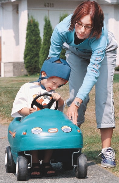
- Photograph of Tina Cibelli, an employee at the Puddle Jumpers Daycare, pushing 4-year-old Benjamin Harrison in a toy car outside of the daycare on Parker Street. The two are participating in the "Walk, Run, Pedal and Roll" fundraising event.
- Repository
- City of Burnaby Archives
- Date
- [2001]
- Collection/Fonds
- Burnaby NewsLeader photograph collection
- Physical Description
- 1 photograph (tiff) : col.
- Description Level
- Item
- Record No.
- 535-2717
- Access Restriction
- No restrictions
- Reproduction Restriction
- No restrictions
- Accession Number
- 2018-12
- Scope and Content
- Photograph of Tina Cibelli, an employee at the Puddle Jumpers Daycare, pushing 4-year-old Benjamin Harrison in a toy car outside of the daycare on Parker Street. The two are participating in the "Walk, Run, Pedal and Roll" fundraising event.
- Subjects
- Persons - Children
- Events - Fundraising
- Media Type
- Photograph
- Photographer
- Bartel, Mario
- Notes
- Title based on caption
- Collected by editorial for use in an August 2001 issue of the Burnaby NewsLeader
- Caption from metadata: "Tina Cibelli, of the Puddle Jumpers Daycare, gives a push to Benjamin Harrison, 4, as they prepare to participate in the second annual "Walk, Run, Pedal and Roll" event to raise money for the Centre of Ability."
- Geographic Access
- Parker Street
- Historic Neighbourhood
- Vancouver Heights (Historic Neighbourhood)
- Planning Study Area
- Willingdon Heights Area
Images
William Holmes fonds
https://search.heritageburnaby.ca/link/museumdescription10416
- Repository
- Burnaby Village Museum
- Date
- [1841]-1994
- Collection/Fonds
- William Holmes fonds
- Description Level
- Fonds
- Physical Description
- 2 photographs (calotype) + 1 photograph : b&w + 6 photographs : col. + 5 p. textual records + 1 newspaper clipping
- Scope and Content
- Fonds consists of photographs pertaining to the William Holmes family, family grave markers in cemetery in Ireland along with original correspondence, land title certificates and a newspaper clipping. Fonds is arranged in series: 1) William Holmes family photographs series 2) William Holmes family…
- Repository
- Burnaby Village Museum
- Collection/Fonds
- William Holmes fonds
- Description Level
- Fonds
- Physical Description
- 2 photographs (calotype) + 1 photograph : b&w + 6 photographs : col. + 5 p. textual records + 1 newspaper clipping
- Scope and Content
- Fonds consists of photographs pertaining to the William Holmes family, family grave markers in cemetery in Ireland along with original correspondence, land title certificates and a newspaper clipping. Fonds is arranged in series: 1) William Holmes family photographs series 2) William Holmes family records series 3) Holmes family cemetery photographs series
- History
- William Holmes was the first non-Indigenous resident of Burnaby and was born in Kilkenny Ireland January 4, 1812. In 1833, at the age of 20 yrs, William Holmes immigrated to Canada from Ireland in with his parents, Joseph and Jane (McCullough) Holmes and ten other family members including two of his married brothers and their wives, two sisters with their husbands and two unmarried brothers. This was the first group of thirteen to leave Ireland and set up homesteads in Canada near the shores of Lake Huron. The family settled on land concessions in Huron County, Ontario about 14 km southeast of Goderich. The area in Huron County was first founded in 1832 by John and Samuel Holmes and the community was known as Holmes Hill before becoming Holmesville [ca. 1850]. In 1837, William Holmes is noted as owning Lot 23, Concession IX, Goderich Twp. Much of the village of Holmesville grew up around the five road concession near the border of his brother’s farm so William decided to open a store. The Holmesville post office opened on March 1, 1855 and William was appointed the first post master which he operated until May 1857. William met and married Mary Richardson in 1841 and the couple had three daughters: Jane (1844-1926) (married Charles Studdert Finlaison in New Westminster in 1863); Anne Maria (Annie) (1846-192?) (married John Gunther Jennings in New Westminster in 1865 and married Robert Johnson in New Westminster in 1877) and Elizabeth (1848-1934) (married Thomas Carrington of Lakes District in 1867). William’s wife, Mary (Richardson) Holmes died in Holmesville sometime between 1848 and 1853. Following the death of his first wife, Mary, William married Charlotte McCullough (McCulloch). The couple had four daughters; Arabella Charlotte Amelia (1854-1943) (married Arthur Robert Green in 1887); Laura (1855-1867); Arabella Henrietta (1857-1929) (married Clark Wesley Gillanders in 1880) and Mary (1863-1864). During the late 1850s, William became aware of the gold rush and opportunities opening up in British Columbia so left for the west coast in 1858 at the age of 46 yrs. In preparation for his move to the west coast of Canada, William obtained a letter of introduction from top government officials of Canada. William Holmes arrived in British Columbia in 1859. Upon arriving, he first worked running pack trains from Harrison Mills to Lillooet. After earning some money, he decided to re-invest it in land. His first pre-emption of land occurred on January 21, 1860 for 160 acres situated on North Road from the Military Camp to Burrard Inlet and distancing 25 chains south of the Brunette River and 20 chains south of the river with the land extending in a westerly direction. On March 17, 1860, Holmes received a Crown Grant for this and other land in the immediate area totalling 415 acres of which was known as Lot No. 1, Group 1, Rural Land, New Westminster District. The balance of land was situated on the east side of the Brunette River – Lot 13, with 344 2/3 acres of which he made an application to purchase on June 26, 1860, and a Crown Grant dated March 16, 1861 covering 86 acres. Holmes also pre-empted land in Port Moody and Pitt Meadows in 1860 and 1861. The name of “Brunette River” is officially attributed to William Holmes who referred to the river as “Brunette” due to it’s dark colour originating from the peat lands above the lake. Following his purchase of property, he sent for his wife Charlotte, their three daughters and her three step daughters (from William’s first marriage). Charlotte and the six children made the long trip to B.C. by ship and rail, crossing the Isthmus of Darien at Panama. They arrived in B.C. in October 1861 and moved into a one room log cabin built by William. The cabin stood on the North Road at the foot of Sapperton, on a bluff overlooking the Brunette River. Eventually the family moved to a larger dwelling but the original cabin remained on the site until the 1890s when it was burned after being used as a sick house. Mr. Holmes was instrumental in organizing the first Orange Lodge in British Columbia. He was a prominent Orangeman who joined the order in 1840 and was the first master in the order of the City of New Westminster when the Lodge No. 1150 was established there. Charlotte Holmes died in New Westminster in 1893 at the age of 70 years and William Holmes died in New Westminster September 11, 1907 at the age of 95 years.
- Responsibility
- Holmes, William
- Accession Code
- HV971.46
- BV997.50
- Date
- [1841]-1994
- Media Type
- Photograph
- Textual Record
- Related Material
- See also: Reference file: Persons - Holmes, William
- Notes
- Title based on contents of fonds