Narrow Results By
Subject
- Accidents - Automobile Accidents 1
- Advertising Medium - Signs and Signboards 1
- Aerial Photographs 2
- Agriculture - Farms 54
- Animals - Cows 2
- Animals - Dogs 1
- Animals - Horses 11
- Animals - Poultry 1
- Buildings - Agricultural - Barns 5
- Buildings - Agricultural - Stables 1
- Buildings - Civic - City Halls 1
- Buildings - Commercial - Drive-in Theatres 5
Creator
- Burnaby Community Heritage Commission 1
- Burnaby Lake Men’s Community Service Club 1
- Burnaby Village Museum 1
- Burnett, Geoffrey K. 1
- Burnett & McGugan, Engineers and Surveyors 1
- Carter, David 1
- Code, Norah 1
- Cooke, Rosemary 1
- Cunningham, W. 2
- Disney, John Harold "Jack" 3
- Friends of Interurban 1223 1
- Killip, Alfred Charles “Charlie” 1
Person / Organization
- Baker, Olivia Mary "Bunty" 1
- Beamish, William Randolph "Ran" 1
- British Columbia Electric Railway Company 1
- Burnaby City Hall 1
- Burnaby Civil Defence 1
- Burnaby General Hospital 1
- Burnaby Lake Riding Academy 7
- Burnaby Lake Saddle Club 7
- Burnaby Village Museum 1
- Cascade Drive-In Theatre 6
- Dominion Photo Company 3
- Ferrier, Vern 1
program
https://search.heritageburnaby.ca/link/museumartifact35998
- Repository
- Burnaby Village Museum
- Accession Code
- BV994.14.10
- Description
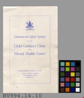
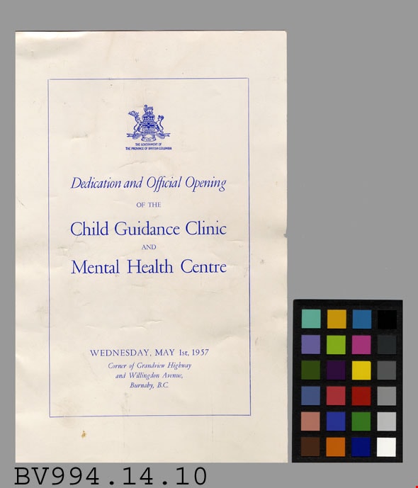
- Dedication and Official Opening - Program -- [1957]. Program for the Dedication and Official Opening ceremony for the Child Guidance Clinic and Mental Health Centre. The ceremony took place on Wednesday, May 1st, 1957 at the corner of Grandview Highway and Willingdon Avenue, Burnaby, B.C. At the top of the program's front cover is the coat of arms for the Government of the Province of British Columbia. Inside, the program details the events of the ceremony. The program measures 14cm x 21.5cm.
- Object History
- This would have come from the donors' father, a medical doctor.
- Colour
- White
- Title
- Dedication and Official Opening of the Child Guidance Clinic and Mental Health Centre
Images
postcard
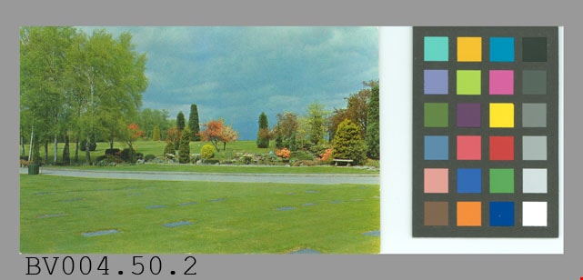
https://search.heritageburnaby.ca/link/museumartifact47196
- Repository
- Burnaby Village Museum
- Accession Code
- BV004.50.2
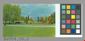
- Description
- Postcard: colour photo, glossy; horizontal; Forest Lawn cemetery; shows lawn, markers, path, trees, shrubs, flowers; on reverse, "Famous for the beauty and unusual design of its magnificent gardens Forest Lawn Memorial Park attracts thousands of visitors every year. It is located on the Grandview Highway at Royal Oak Avenue, only a few miles from downtown Vancouver, B.C."; at lower left, "Colour Photo by Dominion Photo Co."; up centre "A Traveltime PRODUCT, MADE IN VANCOUVER, CANADA, BY GRANT-MANN LITHOGRAPHERS LTD."; maple leaf logo at top "BUY CANADIAN"; at bottom "C-744"; at upper right, "POST CARD" "ADDRESS", outline of rectangle "STAMP"; unused; slight wear on corners
- Classification
- Written Communication T&E - - Writing Media
- Object Term
- Postcard
- Marks/Labels
- Forest Lawn Memorial Park / Grandview Highway / Royal Oak Avenue
- Country Made
- Canada
- Province Made
- British Columbia
- Site/City Made
- Vancouver
- Title
- Forest Lawn Memorial Park C-744
- Names
- Dominion Photo Company
Images
postcard
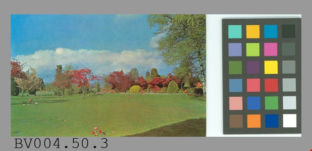
https://search.heritageburnaby.ca/link/museumartifact47197
- Repository
- Burnaby Village Museum
- Accession Code
- BV004.50.3
- Description
- Postcard, colour photo, glossy; horizontal; shows Forest Lawn cemetery, lawn with some markers visible, shrubs and trees in background; on reverse in blue, "Famous for the beauty and unusual design of its magnificent gardens, Forest Lawn Memorial Park attracts thousands of visitors every year. It is located on the Grandview Highway at Royal Oak Avenue, only a few miles from downtown Vancouver, B.C."; at bottom left, "Colour Photo by Dominion Photo Co."; up centre, "A Traveltime PRODUCT, MADE IN VANCOUVER, CANADA, BY GRANT-MANN LITHOGRAPHERS LTD."; maple leaf logo at top "BUY CANADIAN"; at bottom, "C-747"; at upper right, "POST CARD", with "ADDRESS" below; outline of rectangle at upper right corner, "STAMP"; some yellowish stains; corners are worn; creasing at top centre and wear; unused
- Classification
- Written Communication T&E - - Writing Media
- Object Term
- Postcard
- Marks/Labels
- Forest Lawn Memorial Park / Grandview Highway / Royal Oak Avenue
- Country Made
- Canada
- Province Made
- British Columbia
- Site/City Made
- Vancouver
- Title
- Famous for the beauty... Forest Lawn Memorial Park... C-747
- Names
- Dominion Photo Company
Images
postcard
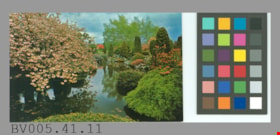
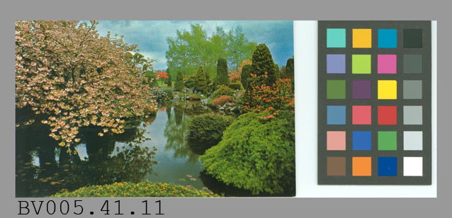
https://search.heritageburnaby.ca/link/museumartifact48617
- Repository
- Burnaby Village Museum
- Accession Code
- BV005.41.11
- Description
- Postcard: colour photo, glossy; horizontal; Forest Lawn cemetery; shows flowering tree and shrubs, trees around lake; on reverse in blue, "Famous for the beauty and design of its magnificent rock gardens and its lovely ornamental trees, Forest Lawn Memorial Park is located on the Grandview Highway at Royal Oak Avenue, Vancouver, B.C."; at bottom left, "Colour Photo by Dominion Photo Co."; up centre, "A Traveltime PRODUCT, MADE IN VANCOUVER, CANADA, BY GRANT-MANN LITHOGRAPHERS LTD."; maple leaf logo at top "BUY CANADIAN"; at bottom, "C-745"; at upper right, "POST CARD" "ADDRESS"; outline of rectangle "STAMP"; unused; very slight wear on corners
- Classification
- Written Communication T&E - - Writing Media
- Object Term
- Postcard
- Marks/Labels
- Forest Lawn / Memorial Park is located on the Grandview Highway at / Royal Oak Avenue, Vancouver, B.C. / C745
- Country Made
- Canada
- Province Made
- British Columbia
- Site/City Made
- Vancouver
- Title
- Forest Lawn Memorial Park C-745
- Names
- Dominion Photo Company
Images
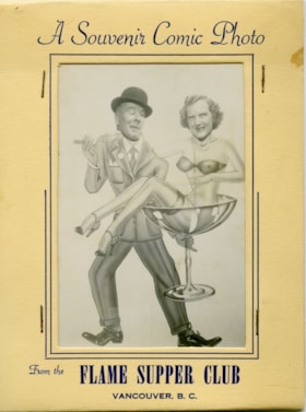
Comic foreground novelty photograph
https://search.heritageburnaby.ca/link/museumdescription10017
- Repository
- Burnaby Village Museum
- Collection/Fonds
- Burnaby Village Museum Photograph collection
- Description Level
- Item
- Physical Description
- 1 photograph : b&w ; 13.0 x 9.0 cm print ; 26.5 x 33.5 cm print in folder
- Scope and Content
- Photograph of couple in a comic foreground novelty photograph. A comic foreground generally consistes of a comedic painted image with holes cut-out where the heads of the figures in the image should be. Sitters then stand behind the image and place their faces into the cut-out holes to comedic effe…
- Repository
- Burnaby Village Museum
- Collection/Fonds
- Burnaby Village Museum Photograph collection
- Description Level
- Item
- Physical Description
- 1 photograph : b&w ; 13.0 x 9.0 cm print ; 26.5 x 33.5 cm print in folder
- Material Details
- Photograph is housed in a beige, thin card, tri-fold folder with rectangular cut-out to view image. Folder has navy blue pinstripe detail around cut-out. Navy blue text above cut-out reads: "A Souvenir Comic Photo". Navy blue text below the cut-out reads: "From the FLAME SUPPER CLUB / VANCOUVER, B.C.".
- Scope and Content
- Photograph of couple in a comic foreground novelty photograph. A comic foreground generally consistes of a comedic painted image with holes cut-out where the heads of the figures in the image should be. Sitters then stand behind the image and place their faces into the cut-out holes to comedic effect. Phil and Marg McClaughlin are pictured in the photograph. Phil is standing behind an illustration of a sharp dressed man wearing a fedora and holding a cigar in one hand. In his other hand, the man holds an over-sized martini glass containing the figure of a scantily clad woman. Marg is standing behind the image of the woman seated in the martini glass.
- History
- The Flame Supper Club was located on the Grandview Highway between Smith and Boundary Road. The address was later given as 3776 Canada Way. The club was touted in advertisements as having "Vancouver's Largest Cabaret Dance Floor". It opened in 1947 and was sold in 1971.
- Names
- Flame Supper Club
- Accession Code
- BV019.1.1
- Access Restriction
- Restricted access
- Reproduction Restriction
- May be restricted by third party rights
- Media Type
- Photograph
- Scan Resolution
- 600
- Scan Date
- 13-Feb-2019
- Notes
- Title based on contents of photograph
Images


Comic foreground novelty photograph
https://search.heritageburnaby.ca/link/museumdescription10018
- Repository
- Burnaby Village Museum
- Collection/Fonds
- Burnaby Village Museum Photograph collection
- Description Level
- Item
- Physical Description
- 1 photograph : b&w ; 13.0 x 9.0 cm print ; 26.5 x 33.5 cm print in folder
- Scope and Content
- Photograph of couple in a comic foreground novelty photograph. A comic foreground generally consistes of a comedic painted image with holes cut-out where the heads of the figures in the image should be. Sitters then stand behind the image and place their faces into the cut-out holes to comedic effe…
- Repository
- Burnaby Village Museum
- Collection/Fonds
- Burnaby Village Museum Photograph collection
- Description Level
- Item
- Physical Description
- 1 photograph : b&w ; 13.0 x 9.0 cm print ; 26.5 x 33.5 cm print in folder
- Material Details
- Photograph is housed in a beige, thin card, tri-fold folder with rectangular cut-out to view image. Folder has navy blue pinstripe detail around cut-out. Navy blue text above cut-out reads: "A Souvenir Comic Photo". Navy blue text below the cut-out reads: "From the FLAME SUPPER CLUB / VANCOUVER, B.C.".
- Scope and Content
- Photograph of couple in a comic foreground novelty photograph. A comic foreground generally consistes of a comedic painted image with holes cut-out where the heads of the figures in the image should be. Sitters then stand behind the image and place their faces into the cut-out holes to comedic effect. Phil and Marg McClaughlin are pictured in the photograph. Marg is standing behind an illustration of a scantily clad woman who is running. Phil is standing behind the image of a clawed, furred animal wearing striped boxer shorts. Text printed beneath the painted image reads: "IT HAPPENED AT / THE Flame VAN B.C.".
- History
- The Flame Supper Club was located on the Grandview Highway between Smith and Boundary Road. The address was later given as 3776 Canada Way. The club was touted in advertisements as having "Vancouver's Largest Cabaret Dance Floor". It opened in 1947 and was sold in 1971.
- Names
- Flame Supper Club
- Accession Code
- BV019.1.2
- Access Restriction
- Restricted access
- Reproduction Restriction
- May be restricted by third party rights
- Media Type
- Photograph
- Scan Resolution
- 600
- Scan Date
- 16/8/2006
- Scale
- 100
- Notes
- Title based on contents of photograph
Images

Bygones of Burnaby : an anecdotal history
https://search.heritageburnaby.ca/link/museumlibrary5462
- Repository
- Burnaby Village Museum
- Author
- McGeachie, Pixie, 1921-
- Publication Date
- 1976
- c1975
- Call Number
- 971.133 MCG COPY 4
- Repository
- Burnaby Village Museum
- Collection
- Digital Reference Collection
- Material Type
- Book
- Call Number
- 971.133 MCG COPY 4
- Author
- McGeachie, Pixie, 1921-
- Place of Publication
- Burnaby, B.C.
- Publisher
- Century Park Museum Association
- Publication Date
- 1976
- c1975
- Physical Description
- 108 p. : ill. ; 23 cm.
- Library Subject (LOC)
- Burnaby (B.C.)--History
- Notes
- 4 copies held: copy 4.
Digital Books

Pioneer tales of Burnaby
https://search.heritageburnaby.ca/link/museumlibrary5860
- Repository
- Burnaby Village Museum
- Collection
- Digital Reference Collection
- Reference Collection
- Material Type
- Book
- ISBN
- 096928280x
- Call Number
- 971.133 SON COPY 4
- Contributor
- Sone, Michael
- Place of Publication
- Burnaby, B.C.
- Publisher
- Corporation of the District of Burnaby
- Publication Date
- c1987
- Physical Description
- 495 p. : ill. ; 31 cm.
- Inscription
- "TR687 - Bryburgh" / handprinted in pencil on frontend page
- Library Subject (LOC)
- Pioneers--British Columbia--Burnaby
- Frontier and pioneer life
- Biography
- Object History
- Early Burnaby as recalled by the settlers themselves who arrived from every corner of the world between 1888 and 1930, some witnessing incorporation of the district in 1892, all seeking a better life for themselves and especially for their children, all helping transform the wilderness into the modern municipality of today.
- Notes
- "Editor Michael Sone".
- Includes index.
- 4 copies held: copy 4
Images

Digital Books

Tram memories : in celebration of the restoration of Interurban 1223
https://search.heritageburnaby.ca/link/museumlibrary5863
- Repository
- Burnaby Village Museum
- Author
- McGeachie, Pixie, 1921-
- Publication Date
- c2007
- Call Number
- 388.460971 TRA
narration
is about. My parents knew the folks that owned the property on the South-East corner of
Burris and Grandview Highway. Quite frequently we would travel on the Interurban to visit
them. We lived in West Point Grey on 10th Avenue above Alma Road and so traveling to
our friends was quite an adventure
- Repository
- Burnaby Village Museum
- Collection
- Digital Reference Collection
- Reference Collection
- Material Type
- Book
- Call Number
- 388.460971 TRA
- Author
- McGeachie, Pixie, 1921-
- Contributor
- Friends of Interurban 1223
- Place of Publication
- Burnaby
- Publisher
- City of Burnaby
- Publication Date
- c2007
- Printer
- City of Burnaby Printshop
- Physical Description
- 91 p. : ill., map ;,20 cm
- Library Subject (LOC)
- Electric railroads
- Local transit
- Street-railroads
- Transportation
- Geographic Access
- Vancouver
- Name Access
- British Columbia Electric Railway Company
- Notes
- Editor : Pixie McGeachie
Images

Digital Books

Douglas Road
https://search.heritageburnaby.ca/link/landmark714
- Repository
- Burnaby Heritage Planning
- Associated Dates
- 1865
- Heritage Value
- Douglas Road was built between 1862-1865 by the Royal Engineers based in New Westminster. Originally known as the Douglas Street Trail, it took its name from Governor James Douglas. In 1926 a new connection was made to reach Grandview Road in Vancouver at Boundary Road. To distinguish this new highway it was renamed the Grandview Highway and it became commonly known as the combined Grandview-Douglas Highway until 1968 when the Burnaby and New Westminister sections were renamed Canada Way, in recognition of Canada's Centennial in 1967. The old part of Douglas Road north of Sprott Street remained intact.
- Historic Neighbourhood
- Burnaby Lake (Historic Neighbourhood)
- Planning Study Area
- Douglas-Gilpin Area
- Street View URL
- Google Maps Street View
Images

Gladys Killip subseries
https://search.heritageburnaby.ca/link/archivedescription58418
- Repository
- City of Burnaby Archives
- Date
- 1904-1998
- Collection/Fonds
- Burnaby Historical Society fonds
- Description Level
- Subseries
- Physical Description
- Textual records and graphic material
- Scope and Content
- Subseries consists of papers pertaining to the Killip family, primarily Gladys Killip's personal activism in the municipality of Burnaby and the causes she supported. Subseries also includes photographs of the Burnaby Council of Women taken during Gladys Killip's time as Publicity Co-Chairwoman du…
- Repository
- City of Burnaby Archives
- Date
- 1904-1998
- Collection/Fonds
- Burnaby Historical Society fonds
- Subseries
- Gladys Killip subseries
- Physical Description
- Textual records and graphic material
- Description Level
- Subseries
- Accession Number
- BHS1996-12
- BHS1998-11
- BHS2000-02
- BHS2007-04
- Scope and Content
- Subseries consists of papers pertaining to the Killip family, primarily Gladys Killip's personal activism in the municipality of Burnaby and the causes she supported. Subseries also includes photographs of the Burnaby Council of Women taken during Gladys Killip's time as Publicity Co-Chairwoman during the 1967 Centennial Celebration festivity "100 Years of Progress in Women's Activities, Arts and Crafts" .
- History
- Gladys M. Yeomans married Alfred Charles “Charlie” Killip in St. Andrew’s Wesley United Church in Vancouver on August 16, 1947. They spent their honeymoon together at the Sunset Inn at Qualicum Beach. The Killips lived in the same house in South Burnaby for the greater part of their married lives. Their address began as 729 Marshall, changed to 729 Hazelmere Street in 1951 (due to bylaw 3133) and again to 7763 Hazelmere Street (due to 1958/1959 street re-numbering). The Killips were activists within Burnaby, writing letters to their member of Council when they felt that the citizens of Burnaby were not being treated fairly. An example of this is when they led the protest against Pacific Stage Lines for reducing its service on the Grandview Highway by making fewer stops and by changing its route. Gladys led their delegation to Council in June of 1964. Gladys was also involved in the activities of the Valley View Players and in Burnaby Little Theatre activities. She was part of the cast of “Crime at Blossoms” in 1951 and held a membership card from 1952 to 1959 for the Valley View Players Club. Among other roles, she was one of the principle actors in “You Can’t Take it With You” and “In the Shadow of the Glen” both performed in 1957. Gladys was the Burnaby Council of Women Publicity Co-Chairwoman. In this capacity she helped to organize such events as the "100 Years of Progress in Women's Activities, Arts and Crafts" for the Centennial Celebration in 1967 (the Burnaby Diamond Jubilee). She was also a founding member of the Century Park Museum Association, which created under the auspices of the Burnaby Centennial '71 Committee, to administer Burnaby's Centennial '71 Commemorative Project, Heritage Village. Both Gladys and Charles Killip were active members of the Monarchist League of Canada. Gladys’ hobby started with a small silver spoon commemorating King George VI taking the throne in 1936. Her collection includes items commemorating every Royal from Prince Edward, Queen Victoria's father, to a cup commemorating one of Prince Williams recent birthdays. Gladys opened the Silver Spoon collectors shop in Burnaby in 1974 and operated it until 1980 when she and her husband Charlie retired to Qualicum Beach and opened Chilham Village Antiques and Collectables in 1984. The Killips earned a Silver Badge of Service from the Monarchist League of Canada in 1992 for their significant contribution to the League’s work. As of November 2010, Ms. Gladys Yeomans’ collection of British Royal family memorabilia has grown so large, that she has countless of mugs, spoons, plates, t-shirts and pieces of poetry, filling a room in her basement and upstairs in her home in Vancouver Island, British Columbia.
- Media Type
- Textual Record
- Photograph
- Notes
- Title based on contents of subseries
- PC497, MSS125, MSS081, MSS085

Broadview School
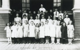
https://search.heritageburnaby.ca/link/archivedescription38237
- Repository
- City of Burnaby Archives
- Date
- 1912
- Collection/Fonds
- Burnaby Historical Society fonds
- Description Level
- Item
- Physical Description
- 1 photograph : sepia ; 16.5 x 21.2 cm on 24.5 x 29.5 cm backing
- Scope and Content
- Photograph of a class of approximately fifty-three children and two teachers outside the newly built Broadview area school. This was the first class photograph at the Broadview School. This shool was later replaced by the Schou Street School and the building was used as a community centre.
- Repository
- City of Burnaby Archives
- Date
- 1912
- Collection/Fonds
- Burnaby Historical Society fonds
- Subseries
- Margaret McCallum subseries
- Physical Description
- 1 photograph : sepia ; 16.5 x 21.2 cm on 24.5 x 29.5 cm backing
- Description Level
- Item
- Record No.
- 375-012
- Access Restriction
- No restrictions
- Reproduction Restriction
- No known restrictions
- Accession Number
- BHS1986-42
- Scope and Content
- Photograph of a class of approximately fifty-three children and two teachers outside the newly built Broadview area school. This was the first class photograph at the Broadview School. This shool was later replaced by the Schou Street School and the building was used as a community centre.
- Names
- Schou Street School
- Media Type
- Photograph
- Notes
- Title based on contents of photograph
- Geographic Access
- Gilmore Avenue
- Grandview Highway
- Canada Way
- Street Address
- 4054 Norfolk Street
- Historic Neighbourhood
- Broadview (Historic Neighbourhood)
- Planning Study Area
- Cascade-Schou Area
Images

![Schou Street School, [between 1913 and 1919] thumbnail](/media/hpo/_Data/_Archives_Images/_Unrestricted/316/325-025.jpg?width=280)
Schou Street School
https://search.heritageburnaby.ca/link/archivedescription37153
- Repository
- City of Burnaby Archives
- Date
- [between 1913 and 1919]
- Collection/Fonds
- Burnaby Historical Society fonds
- Description Level
- Item
- Physical Description
- 1 photograph : b&w ; 8 x 12.5 cm print
- Scope and Content
- Photograph of the Schou Street School and surrounding area.
- Repository
- City of Burnaby Archives
- Date
- [between 1913 and 1919]
- Collection/Fonds
- Burnaby Historical Society fonds
- Subseries
- Disney family subseries
- Physical Description
- 1 photograph : b&w ; 8 x 12.5 cm print
- Description Level
- Item
- Record No.
- 325-025
- Access Restriction
- No restrictions
- Reproduction Restriction
- No known restrictions
- Accession Number
- BHS1996-04
- Scope and Content
- Photograph of the Schou Street School and surrounding area.
- Subjects
- Buildings - Schools
- Names
- Schou Street School
- Media Type
- Photograph
- Photographer
- Disney, John Harold "Jack"
- Notes
- Title based on contents of photograph
- Geographic Access
- Grandview Highway
- Canada Way
- Street Address
- 4054 Norfolk Street
- Historic Neighbourhood
- Broadview (Historic Neighbourhood)
- Planning Study Area
- Cascade-Schou Area
Images
![Schou Street School, [between 1913 and 1919] thumbnail](/media/hpo/_Data/_Archives_Images/_Unrestricted/316/325-025.jpg)
![Schou Street School side entrance, [between 1913 and 1919] thumbnail](/media/hpo/_Data/_Archives_Images/_Unrestricted/316/325-026.jpg?width=280)
Schou Street School side entrance
https://search.heritageburnaby.ca/link/archivedescription37154
- Repository
- City of Burnaby Archives
- Date
- [between 1913 and 1919]
- Collection/Fonds
- Burnaby Historical Society fonds
- Description Level
- Item
- Physical Description
- 1 photograph : b&w ; 8 x 12.5 cm print
- Scope and Content
- Photograph of the side entrance to the Schou Street School, and its surrounding school yard.
- Repository
- City of Burnaby Archives
- Date
- [between 1913 and 1919]
- Collection/Fonds
- Burnaby Historical Society fonds
- Subseries
- Disney family subseries
- Physical Description
- 1 photograph : b&w ; 8 x 12.5 cm print
- Description Level
- Item
- Record No.
- 325-026
- Access Restriction
- No restrictions
- Reproduction Restriction
- No known restrictions
- Accession Number
- BHS1996-04
- Scope and Content
- Photograph of the side entrance to the Schou Street School, and its surrounding school yard.
- Subjects
- Buildings - Schools
- Names
- Schou Street School
- Media Type
- Photograph
- Photographer
- Disney, John Harold "Jack"
- Notes
- Title based on contents of photograph
- Geographic Access
- Grandview Highway
- Canada Way
- Street Address
- 4054 Norfolk Street
- Historic Neighbourhood
- Broadview (Historic Neighbourhood)
- Planning Study Area
- Cascade-Schou Area
Images
![Schou Street School side entrance, [between 1913 and 1919] thumbnail](/media/hpo/_Data/_Archives_Images/_Unrestricted/316/325-026.jpg)
![Schou Street School side entrance, [between 1913 and 1919] thumbnail](/media/hpo/_Data/_Archives_Images/_Unrestricted/316/325-027.jpg?width=280)
Schou Street School side entrance
https://search.heritageburnaby.ca/link/archivedescription37155
- Repository
- City of Burnaby Archives
- Date
- [between 1913 and 1919]
- Collection/Fonds
- Burnaby Historical Society fonds
- Description Level
- Item
- Physical Description
- 1 photograph : b&w ; 7.5 x 12.5 cm print
- Scope and Content
- Photograph of the side entrance to the Schou Street School, and its surrounding school yard.
- Repository
- City of Burnaby Archives
- Date
- [between 1913 and 1919]
- Collection/Fonds
- Burnaby Historical Society fonds
- Subseries
- Disney family subseries
- Physical Description
- 1 photograph : b&w ; 7.5 x 12.5 cm print
- Description Level
- Item
- Record No.
- 325-027
- Access Restriction
- No restrictions
- Reproduction Restriction
- No known restrictions
- Accession Number
- BHS1996-04
- Scope and Content
- Photograph of the side entrance to the Schou Street School, and its surrounding school yard.
- Subjects
- Buildings - Schools
- Names
- Schou Street School
- Media Type
- Photograph
- Photographer
- Disney, John Harold "Jack"
- Notes
- Title based on contents of photograph
- Geographic Access
- Grandview Highway
- Canada Way
- Street Address
- 4054 Norfolk Street
- Historic Neighbourhood
- Broadview (Historic Neighbourhood)
- Planning Study Area
- Cascade-Schou Area
Images
![Schou Street School side entrance, [between 1913 and 1919] thumbnail](/media/hpo/_Data/_Archives_Images/_Unrestricted/316/325-027.jpg)

Schou Street School site
https://search.heritageburnaby.ca/link/museumdescription11138
- Repository
- Burnaby Village Museum
- Date
- April 12, 1915
- Collection/Fonds
- Ronald G. Scobbie collection
- Description Level
- Item
- Physical Description
- 1 survey plan : blueprint on paper ; 56 x 54 cm
- Scope and Content
- Survey plan of "Schou Street School Site / Burnaby Municipality" "Being Lot 1-12 inc. of Block 47, of subd. of Blocks 8-12 and 15-49 inclusive, Lot 69, Group 1" "New Westminster District";
- Repository
- Burnaby Village Museum
- Collection/Fonds
- Ronald G. Scobbie collection
- Description Level
- Item
- Physical Description
- 1 survey plan : blueprint on paper ; 56 x 54 cm
- Material Details
- Scale 40 feet = 1 inch
- Scope and Content
- Survey plan of "Schou Street School Site / Burnaby Municipality" "Being Lot 1-12 inc. of Block 47, of subd. of Blocks 8-12 and 15-49 inclusive, Lot 69, Group 1" "New Westminster District";
- Creator
- Burnett, Geoffrey K.
- Subjects
- Buildings - Schools
- Names
- Schou Street School
- Responsibility
- Burnett & McGugan, Engineers and Surveyors
- Geographic Access
- Canada Way
- Grandview Highway
- Gilmore Avenue
- Street Address
- 4054 Norfolk Street
- Accession Code
- BV003.83.17
- Access Restriction
- No restrictions
- Reproduction Restriction
- No known restrictions
- Date
- April 12, 1915
- Media Type
- Cartographic Material
- Historic Neighbourhood
- Broadview (Historic Neighbourhood)
- Planning Study Area
- Cascade-Schou Area
- Scan Resolution
- 440
- Scan Date
- 22-Dec-2020
- Scale
- 100
- Notes
- Title based on contents of plan
- Oath on plan reads: "I, Geoffrey K. Burnett...did person- ally superintend the survey..." "...completed on the 12th day of April 1915"; signed by Geoffrey K. Burnett, notarized by "S.F. Mark", sworn "..12th day.. April 1915" "Burnett and McGugan" "B.C. Land Surveyors Etc. New Westminster, B.C.
- ."handwritten on back, "1751"
- two school buildings are shown on this blueprint, "Old School Building", "New School Building"
Images

![Broadview District, [1916] (date of original), copied 1992 thumbnail](/media/hpo/_Data/_Archives_Images/_Unrestricted/315/315-117.jpg?width=280)
Broadview District
https://search.heritageburnaby.ca/link/archivedescription36762
- Repository
- City of Burnaby Archives
- Date
- [1916] (date of original), copied 1992
- Collection/Fonds
- Burnaby Historical Society fonds
- Description Level
- Item
- Physical Description
- 1 photograph : b&w ; 7.8 x 12.5 cm print
- Scope and Content
- Photograph of 3300 block of Clydesdale Street (old street numbering) in the Broadview District neighbourhood, looking east toward Gilmore Avenue. Snake Hill (Burnaby Mountain) can be seen in the background. The homes belong to the Singers, the Urquharts, the Esplins, the Strangs, and the Boggusts.…
- Repository
- City of Burnaby Archives
- Date
- [1916] (date of original), copied 1992
- Collection/Fonds
- Burnaby Historical Society fonds
- Subseries
- Burnaby Centennial Anthology subseries
- Physical Description
- 1 photograph : b&w ; 7.8 x 12.5 cm print
- Description Level
- Item
- Record No.
- 315-117
- Access Restriction
- No restrictions
- Reproduction Restriction
- No known restrictions
- Accession Number
- BHS1994-04
- Scope and Content
- Photograph of 3300 block of Clydesdale Street (old street numbering) in the Broadview District neighbourhood, looking east toward Gilmore Avenue. Snake Hill (Burnaby Mountain) can be seen in the background. The homes belong to the Singers, the Urquharts, the Esplins, the Strangs, and the Boggusts. The people are Ken Muir, Eva Swift and Bob Laird (married after the war), and Olivia and Olive Urquhart (daughter and mother).
- Subjects
- Buildings - Residential - Houses
- Occupations - Military Personnel
- Clothing - Military Uniforms
- Media Type
- Photograph
- Notes
- Title based on contents of photograph
- Geographic Access
- Grandview Highway
- Historic Neighbourhood
- Broadview (Historic Neighbourhood)
- Planning Study Area
- Cascade-Schou Area
Images
![Broadview District, [1916] (date of original), copied 1992 thumbnail](/media/hpo/_Data/_Archives_Images/_Unrestricted/315/315-117.jpg)
![School Class, [1920] (date of original), copied 1992 thumbnail](/media/hpo/_Data/_Archives_Images/_Unrestricted/315/315-113.jpg?width=280)
School Class
https://search.heritageburnaby.ca/link/archivedescription36758
- Repository
- City of Burnaby Archives
- Date
- [1920] (date of original), copied 1992
- Collection/Fonds
- Burnaby Historical Society fonds
- Description Level
- Item
- Physical Description
- 1 photograph : b&w ; 8.7 x 12.6 cm print
- Scope and Content
- Photograph of a school class, probably Schou Street School. Some of the children are in costume.
- Repository
- City of Burnaby Archives
- Date
- [1920] (date of original), copied 1992
- Collection/Fonds
- Burnaby Historical Society fonds
- Subseries
- Burnaby Centennial Anthology subseries
- Physical Description
- 1 photograph : b&w ; 8.7 x 12.6 cm print
- Description Level
- Item
- Record No.
- 315-113
- Access Restriction
- No restrictions
- Reproduction Restriction
- No known restrictions
- Accession Number
- BHS1994-04
- Scope and Content
- Photograph of a school class, probably Schou Street School. Some of the children are in costume.
- Subjects
- Clothing - Costumes
- Names
- Schou Street School
- Media Type
- Photograph
- Notes
- Title based on contents of photograph
- Geographic Access
- Gilmore Avenue
- Grandview Highway
- Canada Way
- Street Address
- 4054 Norfolk Street
- Historic Neighbourhood
- Broadview (Historic Neighbourhood)
- Planning Study Area
- Cascade-Schou Area
Images
![School Class, [1920] (date of original), copied 1992 thumbnail](/media/hpo/_Data/_Archives_Images/_Unrestricted/315/315-113.jpg)
![Schou Street School students, [1920] (date of original), copied 1992 thumbnail](/media/hpo/_Data/_Archives_Images/_Unrestricted/315/315-115.jpg?width=280)
Schou Street School students
https://search.heritageburnaby.ca/link/archivedescription36760
- Repository
- City of Burnaby Archives
- Date
- [1920] (date of original), copied 1992
- Collection/Fonds
- Burnaby Historical Society fonds
- Description Level
- Item
- Physical Description
- 1 photograph : b&w ; 8.7 x 12.6 cm print
- Scope and Content
- Photograph of Schou Street School students.
- Repository
- City of Burnaby Archives
- Date
- [1920] (date of original), copied 1992
- Collection/Fonds
- Burnaby Historical Society fonds
- Subseries
- Burnaby Centennial Anthology subseries
- Physical Description
- 1 photograph : b&w ; 8.7 x 12.6 cm print
- Description Level
- Item
- Record No.
- 315-115
- Access Restriction
- No restrictions
- Reproduction Restriction
- No known restrictions
- Accession Number
- BHS1994-04
- Scope and Content
- Photograph of Schou Street School students.
- Names
- Schou Street School
- Media Type
- Photograph
- Notes
- Title based on contents of photograph
- Photographer identifed as "Bridgman"
- Geographic Access
- Gilmore Avenue
- Grandview Highway
- Canada Way
- Street Address
- 4054 Norfolk Street
- Historic Neighbourhood
- Broadview (Historic Neighbourhood)
- Planning Study Area
- Cascade-Schou Area
Images
![Schou Street School students, [1920] (date of original), copied 1992 thumbnail](/media/hpo/_Data/_Archives_Images/_Unrestricted/315/315-115.jpg)
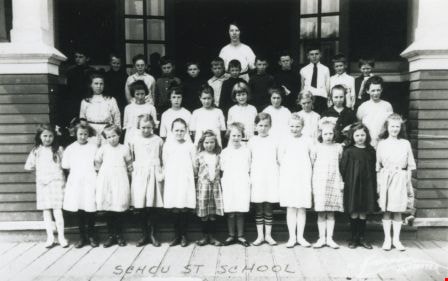
Schou Street School class
https://search.heritageburnaby.ca/link/archivedescription37024
- Repository
- City of Burnaby Archives
- Date
- 1922 (date of original), copied 1992
- Collection/Fonds
- Burnaby Historical Society fonds
- Description Level
- Item
- Physical Description
- 1 photograph : b&w ; 7.7 x 12.0 cm print
- Scope and Content
- Photograph of a Schou Street School class. Identified: (behind children) Miss Chute (teacher).
- Repository
- City of Burnaby Archives
- Date
- 1922 (date of original), copied 1992
- Collection/Fonds
- Burnaby Historical Society fonds
- Subseries
- Burnaby Centennial Anthology subseries
- Physical Description
- 1 photograph : b&w ; 7.7 x 12.0 cm print
- Description Level
- Item
- Record No.
- 315-487
- Access Restriction
- No restrictions
- Reproduction Restriction
- No known restrictions
- Accession Number
- BHS1994-04
- Scope and Content
- Photograph of a Schou Street School class. Identified: (behind children) Miss Chute (teacher).
- Subjects
- Occupations - Teachers
- Names
- Schou Street School
- Media Type
- Photograph
- Geographic Access
- Grandview Highway
- Gilmore Avenue
- Canada Way
- Street Address
- 4054 Norfolk Street
- Historic Neighbourhood
- Broadview (Historic Neighbourhood)
- Planning Study Area
- Cascade-Schou Area
Images