Narrow Results By
Subject
- Accidents - Automobile Accidents 1
- Advertising Medium - Signs and Signboards 1
- Aerial Photographs 2
- Agriculture - Farms 54
- Animals - Cows 2
- Animals - Dogs 1
- Animals - Horses 11
- Animals - Poultry 1
- Buildings - Agricultural - Barns 5
- Buildings - Agricultural - Stables 1
- Buildings - Civic - City Halls 1
- Buildings - Commercial - Drive-in Theatres 5
Creator
- Burnaby Community Heritage Commission 1
- Burnaby Lake Men’s Community Service Club 1
- Burnaby Village Museum 1
- Burnett, Geoffrey K. 1
- Burnett & McGugan, Engineers and Surveyors 1
- Carter, David 1
- Code, Norah 1
- Cooke, Rosemary 1
- Cunningham, W. 2
- Disney, John Harold "Jack" 3
- Friends of Interurban 1223 1
- Killip, Alfred Charles “Charlie” 1
Person / Organization
- Baker, Olivia Mary "Bunty" 1
- Beamish, William Randolph "Ran" 1
- British Columbia Electric Railway Company 1
- Burnaby City Hall 1
- Burnaby Civil Defence 1
- Burnaby General Hospital 1
- Burnaby Lake Riding Academy 7
- Burnaby Lake Saddle Club 7
- Burnaby Village Museum 1
- Cascade Drive-In Theatre 6
- Dominion Photo Company 3
- Ferrier, Vern 1
Certificates of Sufficiency - Nursery Avenue from 6th to Grandview Highway; 15th Avenue East from Cumberland to Wright; Greta Street from McKay to 600 feet East; 6th Street from Stanley to Nursery; and Dubois Street from Boundary to Joffre
https://search.heritageburnaby.ca/link/councilreport41726
- Repository
- City of Burnaby Archives
- Report ID
- 37351
- Meeting Date
- 19-Jan-1959
- Format
- Council - Mayor/Councillor/Staff Report
- Collection/Fonds
- City Council and Office of the City Clerk fonds
- Repository
- City of Burnaby Archives
- Report ID
- 37351
- Meeting Date
- 19-Jan-1959
- Format
- Council - Mayor/Councillor/Staff Report
- Collection/Fonds
- City Council and Office of the City Clerk fonds
Documents
Change of Classification to Commercial Area re Property Abutting on the Grandview Highway between 13th Avenue and Boundary Road and Rosser AVenue and between Royal Oak Avenue and Douglas Road
https://search.heritageburnaby.ca/link/councilreport65768
- Repository
- City of Burnaby Archives
- Report ID
- 56886
- Meeting Date
- 5-Dec-1927
- Format
- Council - Committee Report
- Collection/Fonds
- City Council and Office of the City Clerk fonds
- Repository
- City of Burnaby Archives
- Report ID
- 56886
- Meeting Date
- 5-Dec-1927
- Format
- Council - Committee Report
- Collection/Fonds
- City Council and Office of the City Clerk fonds
Documents

Chicken at Lubbock's farm
https://search.heritageburnaby.ca/link/archivedescription36522
- Repository
- City of Burnaby Archives
- Date
- 1977
- Collection/Fonds
- Burnaby Historical Society fonds
- Description Level
- Item
- Physical Description
- 1 photograph : col. ; 9 x 8.5 cm
- Scope and Content
- Photograph of chickens inside a tall fence at the Lubbock farm. The barn is visible in the background.
- Repository
- City of Burnaby Archives
- Date
- 1977
- Collection/Fonds
- Burnaby Historical Society fonds
- Subseries
- Lubbock family subseries
- Physical Description
- 1 photograph : col. ; 9 x 8.5 cm
- Description Level
- Item
- Record No.
- 289-011
- Access Restriction
- No restrictions
- Reproduction Restriction
- Reproduce for fair dealing purposes only
- Accession Number
- BHS1992-24
- Scope and Content
- Photograph of chickens inside a tall fence at the Lubbock farm. The barn is visible in the background.
- Subjects
- Animals - Poultry
- Agriculture - Farms
- Media Type
- Photograph
- Notes
- Title based on contents of photograph
- Geographic Access
- Grandview Highway
- Canada Way
- Burris Street
- Street Address
- 7803 Burris Street
- Historic Neighbourhood
- Burnaby Lake (Historic Neighbourhood)
- Planning Study Area
- Morley-Buckingham Area
Images


Chicken coop building
https://search.heritageburnaby.ca/link/museumdescription12796
- Repository
- Burnaby Village Museum
- Date
- 1977
- Collection/Fonds
- Century Park Museum Association fonds
- Description Level
- Item
- Physical Description
- 1 photograph : col. slide ; 35 mm
- Scope and Content
- Photograph of a building that was used as a chicken coop on the Lubbock farm located at 7803 Burris Street near Burnaby Lake.
- Repository
- Burnaby Village Museum
- Collection/Fonds
- Century Park Museum Association fonds
- Description Level
- Item
- Physical Description
- 1 photograph : col. slide ; 35 mm
- Scope and Content
- Photograph of a building that was used as a chicken coop on the Lubbock farm located at 7803 Burris Street near Burnaby Lake.
- History
- In 1977, Century Park Museum was granted access to the Sprott-Lubbock farm to appraise the heritage buildings for preservation. Buildings that were saved included the old farrier shed (BV985.1240.2) which was also used as a blacksmith shop and the Vorce tram station building (BV985.1240.3) from the old Burnaby Lake Interurban line which was used as a grain storage shed on the property. Segments of the original farmhouse and other out buildings were retained. Other buildings on the site were demolished to make way for a new housing development.
- Subjects
- Agriculture - Farms
- Names
- Lubbock farm
- Geographic Access
- Grandview Highway
- Burris Street
- Street Address
- 7803 Burris Street
- Accession Code
- BV020.5.473
- Access Restriction
- No restrictions
- Reproduction Restriction
- No known restrictions
- Date
- 1977
- Media Type
- Photograph
- Historic Neighbourhood
- Burnaby Lake (Historic Neighbourhood)
- Planning Study Area
- Morley-Buckingham Area
- Scan Resolution
- 2400
- Scan Date
- 13-Mar-20
- Scale
- 100
- Notes
- Title based on contents of photograph
Images

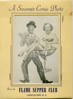
Comic foreground novelty photograph
https://search.heritageburnaby.ca/link/museumdescription10017
- Repository
- Burnaby Village Museum
- Collection/Fonds
- Burnaby Village Museum Photograph collection
- Description Level
- Item
- Physical Description
- 1 photograph : b&w ; 13.0 x 9.0 cm print ; 26.5 x 33.5 cm print in folder
- Scope and Content
- Photograph of couple in a comic foreground novelty photograph. A comic foreground generally consistes of a comedic painted image with holes cut-out where the heads of the figures in the image should be. Sitters then stand behind the image and place their faces into the cut-out holes to comedic effe…
- Repository
- Burnaby Village Museum
- Collection/Fonds
- Burnaby Village Museum Photograph collection
- Description Level
- Item
- Physical Description
- 1 photograph : b&w ; 13.0 x 9.0 cm print ; 26.5 x 33.5 cm print in folder
- Material Details
- Photograph is housed in a beige, thin card, tri-fold folder with rectangular cut-out to view image. Folder has navy blue pinstripe detail around cut-out. Navy blue text above cut-out reads: "A Souvenir Comic Photo". Navy blue text below the cut-out reads: "From the FLAME SUPPER CLUB / VANCOUVER, B.C.".
- Scope and Content
- Photograph of couple in a comic foreground novelty photograph. A comic foreground generally consistes of a comedic painted image with holes cut-out where the heads of the figures in the image should be. Sitters then stand behind the image and place their faces into the cut-out holes to comedic effect. Phil and Marg McClaughlin are pictured in the photograph. Phil is standing behind an illustration of a sharp dressed man wearing a fedora and holding a cigar in one hand. In his other hand, the man holds an over-sized martini glass containing the figure of a scantily clad woman. Marg is standing behind the image of the woman seated in the martini glass.
- History
- The Flame Supper Club was located on the Grandview Highway between Smith and Boundary Road. The address was later given as 3776 Canada Way. The club was touted in advertisements as having "Vancouver's Largest Cabaret Dance Floor". It opened in 1947 and was sold in 1971.
- Names
- Flame Supper Club
- Accession Code
- BV019.1.1
- Access Restriction
- Restricted access
- Reproduction Restriction
- May be restricted by third party rights
- Media Type
- Photograph
- Scan Resolution
- 600
- Scan Date
- 13-Feb-2019
- Notes
- Title based on contents of photograph
Images


Comic foreground novelty photograph
https://search.heritageburnaby.ca/link/museumdescription10018
- Repository
- Burnaby Village Museum
- Collection/Fonds
- Burnaby Village Museum Photograph collection
- Description Level
- Item
- Physical Description
- 1 photograph : b&w ; 13.0 x 9.0 cm print ; 26.5 x 33.5 cm print in folder
- Scope and Content
- Photograph of couple in a comic foreground novelty photograph. A comic foreground generally consistes of a comedic painted image with holes cut-out where the heads of the figures in the image should be. Sitters then stand behind the image and place their faces into the cut-out holes to comedic effe…
- Repository
- Burnaby Village Museum
- Collection/Fonds
- Burnaby Village Museum Photograph collection
- Description Level
- Item
- Physical Description
- 1 photograph : b&w ; 13.0 x 9.0 cm print ; 26.5 x 33.5 cm print in folder
- Material Details
- Photograph is housed in a beige, thin card, tri-fold folder with rectangular cut-out to view image. Folder has navy blue pinstripe detail around cut-out. Navy blue text above cut-out reads: "A Souvenir Comic Photo". Navy blue text below the cut-out reads: "From the FLAME SUPPER CLUB / VANCOUVER, B.C.".
- Scope and Content
- Photograph of couple in a comic foreground novelty photograph. A comic foreground generally consistes of a comedic painted image with holes cut-out where the heads of the figures in the image should be. Sitters then stand behind the image and place their faces into the cut-out holes to comedic effect. Phil and Marg McClaughlin are pictured in the photograph. Marg is standing behind an illustration of a scantily clad woman who is running. Phil is standing behind the image of a clawed, furred animal wearing striped boxer shorts. Text printed beneath the painted image reads: "IT HAPPENED AT / THE Flame VAN B.C.".
- History
- The Flame Supper Club was located on the Grandview Highway between Smith and Boundary Road. The address was later given as 3776 Canada Way. The club was touted in advertisements as having "Vancouver's Largest Cabaret Dance Floor". It opened in 1947 and was sold in 1971.
- Names
- Flame Supper Club
- Accession Code
- BV019.1.2
- Access Restriction
- Restricted access
- Reproduction Restriction
- May be restricted by third party rights
- Media Type
- Photograph
- Scan Resolution
- 600
- Scan Date
- 16/8/2006
- Scale
- 100
- Notes
- Title based on contents of photograph
Images

Complaint of Drainage Nuisance at Cocoanut Drive - Grandview Highway
https://search.heritageburnaby.ca/link/councilreport56483
- Repository
- City of Burnaby Archives
- Report ID
- 77872
- Meeting Date
- 13-Jun-1934
- Format
- Council - Mayor/Councillor/Staff Report
- Collection/Fonds
- City Council and Office of the City Clerk fonds
- Repository
- City of Burnaby Archives
- Report ID
- 77872
- Meeting Date
- 13-Jun-1934
- Format
- Council - Mayor/Councillor/Staff Report
- Collection/Fonds
- City Council and Office of the City Clerk fonds
Documents
Complaint of Mr. And Mrs. Shogan - Property at the Corner of Edmonds and Grandview Highway
https://search.heritageburnaby.ca/link/councilreport43032
- Repository
- City of Burnaby Archives
- Report ID
- 39135
- Meeting Date
- 11-Jun-1957
- Format
- Council - Committee Report
- Collection/Fonds
- City Council and Office of the City Clerk fonds
- Repository
- City of Burnaby Archives
- Report ID
- 39135
- Meeting Date
- 11-Jun-1957
- Format
- Council - Committee Report
- Collection/Fonds
- City Council and Office of the City Clerk fonds
Documents
Completion of Crossovers on Grandview Highway
https://search.heritageburnaby.ca/link/councilreport47523
- Repository
- City of Burnaby Archives
- Report ID
- 47242
- Meeting Date
- 3-Jul-1950
- Format
- Council - Mayor/Councillor/Staff Report
- Collection/Fonds
- City Council and Office of the City Clerk fonds
- Repository
- City of Burnaby Archives
- Report ID
- 47242
- Meeting Date
- 3-Jul-1950
- Format
- Council - Mayor/Councillor/Staff Report
- Collection/Fonds
- City Council and Office of the City Clerk fonds
Documents
Completion of the Grandview Highway Watermain Renewal
https://search.heritageburnaby.ca/link/councilreport47573
- Repository
- City of Burnaby Archives
- Report ID
- 47197
- Meeting Date
- 22-May-1950
- Format
- Council - Committee Report
- Collection/Fonds
- City Council and Office of the City Clerk fonds
- Repository
- City of Burnaby Archives
- Report ID
- 47197
- Meeting Date
- 22-May-1950
- Format
- Council - Committee Report
- Collection/Fonds
- City Council and Office of the City Clerk fonds
Documents
Construction Estimate for Willingdon Avenue from Hastings Street to Grandview Highway
https://search.heritageburnaby.ca/link/councilreport64172
- Repository
- City of Burnaby Archives
- Report ID
- 55402
- Meeting Date
- 6-Jan-1930
- Format
- Council - Mayor/Councillor/Staff Report
- Collection/Fonds
- City Council and Office of the City Clerk fonds
- Repository
- City of Burnaby Archives
- Report ID
- 55402
- Meeting Date
- 6-Jan-1930
- Format
- Council - Mayor/Councillor/Staff Report
- Collection/Fonds
- City Council and Office of the City Clerk fonds
Documents
Construction of a Bus Pull Off Area on the South Side of the Grandview Highway Opposite the Golf Driving Range
https://search.heritageburnaby.ca/link/councilreport47392
- Repository
- City of Burnaby Archives
- Report ID
- 47377
- Meeting Date
- 23-Oct-1950
- Format
- Council - Committee Report
- Collection/Fonds
- City Council and Office of the City Clerk fonds
- Repository
- City of Burnaby Archives
- Report ID
- 47377
- Meeting Date
- 23-Oct-1950
- Format
- Council - Committee Report
- Collection/Fonds
- City Council and Office of the City Clerk fonds
Documents
Construction of Buildings by Provincial Government at Willingdon Avenue and Grandview Highway
https://search.heritageburnaby.ca/link/councilreport44968
- Repository
- City of Burnaby Archives
- Report ID
- 44124
- Meeting Date
- 21-Mar-1955
- Format
- Council - Mayor/Councillor/Staff Report
- Collection/Fonds
- City Council and Office of the City Clerk fonds
- Repository
- City of Burnaby Archives
- Report ID
- 44124
- Meeting Date
- 21-Mar-1955
- Format
- Council - Mayor/Councillor/Staff Report
- Collection/Fonds
- City Council and Office of the City Clerk fonds
Documents

Construction of Saint Theresa's Roman Catholic Church
https://search.heritageburnaby.ca/link/museumdescription903
- Repository
- Burnaby Village Museum
- Date
- March 19, 1929
- Collection/Fonds
- Burnaby Village Museum Photograph collection
- Description Level
- Item
- Physical Description
- 1 photograph : sepia ; 6.9 x 11.5 cm
- Scope and Content
- Photograph of Douglas Road (later renamed in part Canada Way) with Laurel Street in the background on the left and the site of Saint Theresa's Roman Catholic Church as a lot with blackened stumps. The church was located at the southeast corner of Canada Way and Laurel Street. The photograph is ta…
- Repository
- Burnaby Village Museum
- Collection/Fonds
- Burnaby Village Museum Photograph collection
- Description Level
- Item
- Physical Description
- 1 photograph : sepia ; 6.9 x 11.5 cm
- Scope and Content
- Photograph of Douglas Road (later renamed in part Canada Way) with Laurel Street in the background on the left and the site of Saint Theresa's Roman Catholic Church as a lot with blackened stumps. The church was located at the southeast corner of Canada Way and Laurel Street. The photograph is taken from the same angle as HV975.105.1. There is a freight wagon loaded with lumber, pulled by two horses on Douglas Road. An annotation on the back of the photo reads, "March 19th 1929 / The first load of lumber taken for the construction of St St [sic] Therese [sic] Church on the Grandview Highway / Burnaby BC."
- Geographic Access
- Douglas Road
- Canada Way
- Laurel Street
- Accession Code
- HV975.105.2
- Access Restriction
- No restrictions
- Reproduction Restriction
- No known restrictions
- Date
- March 19, 1929
- Media Type
- Photograph
- Historic Neighbourhood
- Burnaby Lake (Historic Neighbourhood)
- Planning Study Area
- Douglas-Gilpin Area
- Scan Resolution
- 600
- Scan Date
- 2023-06-13
- Notes
- Title based on contents of photograph
- Information on the scope and content of the photograph is taken from an acquisition record from the time of the accession
Images

Construction of Sewer on Boundary Road from Great Northern Railway to Grandview Highway
https://search.heritageburnaby.ca/link/councilreport64621
- Repository
- City of Burnaby Archives
- Report ID
- 55854
- Meeting Date
- 19-May-1930
- Format
- Council - Committee Report
- Collection/Fonds
- City Council and Office of the City Clerk fonds
- Repository
- City of Burnaby Archives
- Report ID
- 55854
- Meeting Date
- 19-May-1930
- Format
- Council - Committee Report
- Collection/Fonds
- City Council and Office of the City Clerk fonds
Documents
Cost of Extending the Curb and Pavement of the Westerly Approach of the Municipal Hall to Grandview Highway
https://search.heritageburnaby.ca/link/councilreport43758
- Repository
- City of Burnaby Archives
- Report ID
- 43570
- Meeting Date
- 10-Aug-1956
- Format
- Council - Mayor/Councillor/Staff Report
- Collection/Fonds
- City Council and Office of the City Clerk fonds
- Repository
- City of Burnaby Archives
- Report ID
- 43570
- Meeting Date
- 10-Aug-1956
- Format
- Council - Mayor/Councillor/Staff Report
- Collection/Fonds
- City Council and Office of the City Clerk fonds
Documents
Cost Report - Construction and paving of land immediately east of Gilmore Avenue between the Grandview Highway and Gilmore Diversion
https://search.heritageburnaby.ca/link/councilreport17498
- Repository
- City of Burnaby Archives
- Report ID
- 528
- Meeting Date
- 6-Sep-1983
- Format
- Council - Manager's Report
- Manager's Report No.
- 54
- Item No.
- 3
- Collection/Fonds
- City Council and Office of the City Clerk fonds
- Repository
- City of Burnaby Archives
- Report ID
- 528
- Meeting Date
- 6-Sep-1983
- Format
- Council - Manager's Report
- Manager's Report No.
- 54
- Item No.
- 3
- Collection/Fonds
- City Council and Office of the City Clerk fonds
Documents
Cost Report for the Construction of a Sidewalk on the North Side of Grandview Highway
https://search.heritageburnaby.ca/link/councilreport44756
- Repository
- City of Burnaby Archives
- Report ID
- 44333
- Meeting Date
- 24-May-1955
- Format
- Council - Mayor/Councillor/Staff Report
- Collection/Fonds
- City Council and Office of the City Clerk fonds
- Repository
- City of Burnaby Archives
- Report ID
- 44333
- Meeting Date
- 24-May-1955
- Format
- Council - Mayor/Councillor/Staff Report
- Collection/Fonds
- City Council and Office of the City Clerk fonds
Documents
Crosswalk at Grandview Highway at Sperling Avenue
https://search.heritageburnaby.ca/link/councilreport42245
- Repository
- City of Burnaby Archives
- Report ID
- 38207
- Meeting Date
- 21-Apr-1958
- Format
- Council - Committee Report
- Collection/Fonds
- City Council and Office of the City Clerk fonds
- Repository
- City of Burnaby Archives
- Report ID
- 38207
- Meeting Date
- 21-Apr-1958
- Format
- Council - Committee Report
- Collection/Fonds
- City Council and Office of the City Clerk fonds
Crosswalk at Royal Oak Avenue and Grandview Highway at Laurel Street
https://search.heritageburnaby.ca/link/councilreport42076
- Repository
- City of Burnaby Archives
- Report ID
- 38365
- Meeting Date
- 14-Jul-1958
- Format
- Council - Committee Report
- Collection/Fonds
- City Council and Office of the City Clerk fonds
- Repository
- City of Burnaby Archives
- Report ID
- 38365
- Meeting Date
- 14-Jul-1958
- Format
- Council - Committee Report
- Collection/Fonds
- City Council and Office of the City Clerk fonds