Narrow Results By
Subject
- Advertising Medium - Signs and Signboards 6
- Aerial Photographs 11
- Agriculture - Farms 1
- Animals - Dogs 5
- Buildings - Civic - Archives 1
- Buildings - Civic - City Halls 1
- Buildings - Civic - Fire Halls 2
- Buildings - Civic - Hospitals 3
- Buildings - Commercial 7
- Buildings - Commercial - Offices 1
- Buildings - Commercial - Restaurants 1
- Buildings - Commercial - Stores 4

#6 Firehall
https://search.heritageburnaby.ca/link/archivedescription93703
- Repository
- City of Burnaby Archives
- Date
- February 15, 1978
- Collection/Fonds
- Burnaby Public Library Contemporary Visual Archive Project
- Description Level
- Item
- Physical Description
- 1 photograph : b&w ; 12.5 x 17.5 cm
- Scope and Content
- Photograph of the front exterior of Burnaby Fire Hall No. 6, located at 3620 Brighton Avenue, at the corner of Brighton Avenue and Government Street. The photograph is taken from across Brighton Avenue, facing east. One of the fire hall's garage doors is open and a person and car are inside. The Fu…
- Repository
- City of Burnaby Archives
- Date
- February 15, 1978
- Collection/Fonds
- Burnaby Public Library Contemporary Visual Archive Project
- Physical Description
- 1 photograph : b&w ; 12.5 x 17.5 cm
- Description Level
- Item
- Record No.
- 556-660
- Access Restriction
- No restrictions
- Reproduction Restriction
- Reproduce for fair dealing purposes only
- Accession Number
- 2017-57
- Scope and Content
- Photograph of the front exterior of Burnaby Fire Hall No. 6, located at 3620 Brighton Avenue, at the corner of Brighton Avenue and Government Street. The photograph is taken from across Brighton Avenue, facing east. One of the fire hall's garage doors is open and a person and car are inside. The Furniture Fair warehouse is visible behind the fire hall.
- Names
- Burnaby Fire Department
- Media Type
- Photograph
- Photographer
- Surridge, Jack
- Notes
- Title taken from project information form
- Accompanied by a project information form and 1 photograph (b&w negative ; 9.5 x 12.5 cm)
- BPL no. 108
- Geographic Access
- Government Street
- Brighton Avenue
- Street Address
- 3620 Brighton Avenue
- Historic Neighbourhood
- Lozells (Historic Neighbourhood)
- Planning Study Area
- Government Road Area
Images

4200 Phillips Ave
https://search.heritageburnaby.ca/link/archivedescription94317
- Repository
- City of Burnaby Archives
- Date
- September 1994
- Collection/Fonds
- Grover, Elliott & Co. Ltd. fonds
- Description Level
- File
- Physical Description
- 24 photographs : col. negatives ; 35 mm
- Scope and Content
- Photographs of the exterior of a single-storey industrial building located at 4200 Phillips Avenue - an address that no longer exists.
- Repository
- City of Burnaby Archives
- Date
- September 1994
- Collection/Fonds
- Grover, Elliott & Co. Ltd. fonds
- Physical Description
- 24 photographs : col. negatives ; 35 mm
- Description Level
- File
- Record No.
- 622-102
- Access Restriction
- No restrictions
- Reproduction Restriction
- No restrictions
- Accession Number
- 2017-39
- Scope and Content
- Photographs of the exterior of a single-storey industrial building located at 4200 Phillips Avenue - an address that no longer exists.
- Subjects
- Buildings - Industrial
- Media Type
- Photograph
- Notes
- Transcribed title
- Title transcribed from envelope photographs were originally housed in
- File no. 94-329-B
- Photographer identified as "J.C."
- Geographic Access
- Phillips Avenue
- Historic Neighbourhood
- Lozells (Historic Neighbourhood)
- Planning Study Area
- Government Road Area
7018-7092 Lougheed Hwy [at] SW intersection w/ Bainbridge Ave
https://search.heritageburnaby.ca/link/archivedescription93715
- Repository
- City of Burnaby Archives
- Date
- 1987
- Collection/Fonds
- Grover, Elliott & Co. Ltd. fonds
- Description Level
- File
- Physical Description
- 17 photographs : col. ; 10 cm x 15 cm
- Scope and Content
- Photographs of the commercial properties located at 7018-7092 Lougheed Highway and the surrounding area. Photographs depict the buildings' exteriors, interiors, and roof. Also included in the file is one photograph of a map of Sechelt being marked up.
- Repository
- City of Burnaby Archives
- Date
- 1987
- Collection/Fonds
- Grover, Elliott & Co. Ltd. fonds
- Physical Description
- 17 photographs : col. ; 10 cm x 15 cm
- Description Level
- File
- Record No.
- 622-004
- Access Restriction
- No restrictions
- Reproduction Restriction
- No restrictions
- Accession Number
- 2017-39
- Scope and Content
- Photographs of the commercial properties located at 7018-7092 Lougheed Highway and the surrounding area. Photographs depict the buildings' exteriors, interiors, and roof. Also included in the file is one photograph of a map of Sechelt being marked up.
- Media Type
- Photograph
- Notes
- Transcribed title
- Title transcribed from original print envelope
- File no. 87-201-B
- Geographic Access
- Lougheed Highway
- Street Address
- 7018 Lougheed Highway
- Planning Study Area
- Government Road Area
7260 Winston St
https://search.heritageburnaby.ca/link/archivedescription93887
- Repository
- City of Burnaby Archives
- Date
- April 1993
- Collection/Fonds
- Grover, Elliott & Co. Ltd. fonds
- Description Level
- File
- Physical Description
- 36 photographs : col. negatives ; 35 mm
- Scope and Content
- Photographs of the exterior and parking lot of Smith Paper, located at 7260 Winston Street.
- Repository
- City of Burnaby Archives
- Date
- April 1993
- Collection/Fonds
- Grover, Elliott & Co. Ltd. fonds
- Physical Description
- 36 photographs : col. negatives ; 35 mm
- Description Level
- File
- Record No.
- 622-070
- Access Restriction
- No restrictions
- Reproduction Restriction
- No restrictions
- Accession Number
- 2017-39
- Scope and Content
- Photographs of the exterior and parking lot of Smith Paper, located at 7260 Winston Street.
- Subjects
- Buildings - Commercial
- Media Type
- Photograph
- Notes
- Transcribed title
- Title transcribed from envelope photographs were originally housed in
- File no. 93-175-B
- Photographer identified as "K.H."
- Geographic Access
- Winston Street
- Street Address
- 7260 Winston Street
- Historic Neighbourhood
- Lozells (Historic Neighbourhood)
- Planning Study Area
- Government Road Area
7260 Winston St.
https://search.heritageburnaby.ca/link/archivedescription94312
- Repository
- City of Burnaby Archives
- Date
- June 1994
- Collection/Fonds
- Grover, Elliott & Co. Ltd. fonds
- Description Level
- File
- Physical Description
- 49 photographs : col. negatives ; 35 mm
- Scope and Content
- Photographs of the exterior of Unisource, located at 7260 Winston Street.
- Repository
- City of Burnaby Archives
- Date
- June 1994
- Collection/Fonds
- Grover, Elliott & Co. Ltd. fonds
- Physical Description
- 49 photographs : col. negatives ; 35 mm
- Description Level
- File
- Record No.
- 622-097
- Access Restriction
- No restrictions
- Reproduction Restriction
- No restrictions
- Accession Number
- 2017-39
- Scope and Content
- Photographs of the exterior of Unisource, located at 7260 Winston Street.
- Subjects
- Buildings - Industrial
- Media Type
- Photograph
- Notes
- Transcribed title
- Title transcribed from envelope photographs were originally housed in
- File no. 94-214-B
- Photographer identified as "K.H."
- Geographic Access
- Winston Street
- Street Address
- 7260 Winston Street
- Historic Neighbourhood
- Lozells (Historic Neighbourhood)
- Planning Study Area
- Government Road Area
7973-7993 Enterprise St
https://search.heritageburnaby.ca/link/archivedescription94296
- Repository
- City of Burnaby Archives
- Date
- December 1993
- Collection/Fonds
- Grover, Elliott & Co. Ltd. fonds
- Description Level
- File
- Physical Description
- 46 photographs : col. negatives ; 35 mm
- Scope and Content
- Photographs of the commercial complex located at 7973-7993 Enterprise Street.
- Repository
- City of Burnaby Archives
- Date
- December 1993
- Collection/Fonds
- Grover, Elliott & Co. Ltd. fonds
- Physical Description
- 46 photographs : col. negatives ; 35 mm
- Description Level
- File
- Record No.
- 622-081
- Access Restriction
- No restrictions
- Reproduction Restriction
- No restrictions
- Accession Number
- 2017-39
- Scope and Content
- Photographs of the commercial complex located at 7973-7993 Enterprise Street.
- Media Type
- Photograph
- Notes
- Transcribed title
- Title transcribed from envelope photographs were originally housed in
- File no. 93-464-B
- Photographer identified as "K.H."
- Geographic Access
- Enterprise Street
- Street Address
- 7973 Enterprise Street
- 7993 Enterprise Street
- Historic Neighbourhood
- Lozells (Historic Neighbourhood)
- Planning Study Area
- Government Road Area
8575 Government Street
https://search.heritageburnaby.ca/link/archivedescription93738
- Repository
- City of Burnaby Archives
- Date
- March 1989
- Collection/Fonds
- Grover, Elliott & Co. Ltd. fonds
- Description Level
- File
- Physical Description
- 4 photographs : col. ; 10 cm x 15 cm
- Scope and Content
- Photographs of the industrial complex located at 8575 Government Street under construction.
- Repository
- City of Burnaby Archives
- Date
- March 1989
- Collection/Fonds
- Grover, Elliott & Co. Ltd. fonds
- Physical Description
- 4 photographs : col. ; 10 cm x 15 cm
- Description Level
- File
- Record No.
- 622-023
- Access Restriction
- No restrictions
- Reproduction Restriction
- No restrictions
- Accession Number
- 2017-39
- Scope and Content
- Photographs of the industrial complex located at 8575 Government Street under construction.
- Media Type
- Photograph
- Notes
- Transcribed title
- Title transcribed from sticky note adhered to photograph 622-023-1
- File no. 89-125-B
- Photograph 622-023-1 caption reads: "View north from Government Street"
- Photograph 622-023-2 caption reads: "Eastern view along Government Street; Note Gaglardi Way overpass"
- Photograph 622-023-3 caption reads: "Rear of building"
- Photograph 622-023-4 caption reads: "Southern view along main facade"
- Photograph captions transcribed from the paper on which the photographs were originally adhered.
- Geographic Access
- Government Street
- Street Address
- 8575 Government Street
- Planning Study Area
- Lake City Area

Abandonded farm house
https://search.heritageburnaby.ca/link/archivedescription36511
- Repository
- City of Burnaby Archives
- Date
- 1950
- Collection/Fonds
- Burnaby Historical Society fonds
- Description Level
- Item
- Physical Description
- 1 photograph : b&w ; 8.5 x 14 cm
- Scope and Content
- Photograph of an abandoned farm house on Government Road.
- Repository
- City of Burnaby Archives
- Date
- 1950
- Collection/Fonds
- Burnaby Historical Society fonds
- Subseries
- Photographs subseries
- Physical Description
- 1 photograph : b&w ; 8.5 x 14 cm
- Description Level
- Item
- Record No.
- 288-002
- Access Restriction
- No restrictions
- Reproduction Restriction
- Reproduce for fair dealing purposes only
- Accession Number
- BHS1992-23
- Scope and Content
- Photograph of an abandoned farm house on Government Road.
- Media Type
- Photograph
- Notes
- Title based on contents of photograph
- Photograph is a modern contact print of an original negative that was loaned to the Archives
- Geographic Access
- Government Road
- Historic Neighbourhood
- Lochdale (Historic Neighbourhood)
- Planning Study Area
- Government Road Area
Images


Administration Building New Haven Borstal
https://search.heritageburnaby.ca/link/archivedescription93663
- Repository
- City of Burnaby Archives
- Date
- January 15, 1978
- Collection/Fonds
- Burnaby Public Library Contemporary Visual Archive Project
- Description Level
- Item
- Physical Description
- 1 photograph : b&w ; 12.5 x 17.5 cm
- Scope and Content
- Photograph of the exterior of the administration building at the New Haven Borstal Institute. The photograph is taken from across the lawn, facing northwest. A man is looking into the window of the building on the left.
- Repository
- City of Burnaby Archives
- Date
- January 15, 1978
- Collection/Fonds
- Burnaby Public Library Contemporary Visual Archive Project
- Physical Description
- 1 photograph : b&w ; 12.5 x 17.5 cm
- Description Level
- Item
- Record No.
- 556-620
- Access Restriction
- No restrictions
- Reproduction Restriction
- Reproduce for fair dealing purposes only
- Accession Number
- 2017-57
- Scope and Content
- Photograph of the exterior of the administration building at the New Haven Borstal Institute. The photograph is taken from across the lawn, facing northwest. A man is looking into the window of the building on the left.
- Subjects
- Buildings - Public - Detention Facilities
- Buildings - Schools
- Buildings - Heritage
- Government - Provincial Government
- Media Type
- Photograph
- Photographer
- Surridge, Jack
- Notes
- Title taken from project information form
- Accompanied by a project information form and 1 photograph (b&w negative ; 9.5 x 12.5 cm)
- BPL no. 69
- Street Address
- 4520 Marine Drive
- Historic Neighbourhood
- Fraser Arm (Historic Neighbourhood)
- Planning Study Area
- Big Bend Area
Images

Aerial photograph of Burnaby
https://search.heritageburnaby.ca/link/archivedescription84892
- Repository
- City of Burnaby Archives
- Date
- 1963
- Collection/Fonds
- Allan Amundsen collection
- Description Level
- Item
- Physical Description
- 1 photograph : b&w ; 22.5 x 22.5 cm
- Scope and Content
- Aerial photograph of Burnaby north of Lougheed Highway.
- Repository
- City of Burnaby Archives
- Date
- 1963
- Collection/Fonds
- Allan Amundsen collection
- Physical Description
- 1 photograph : b&w ; 22.5 x 22.5 cm
- Description Level
- Item
- Record No.
- 561-013
- Access Restriction
- In Archives only
- Reproduction Restriction
- No reproduction permitted
- Accession Number
- 2014-08
- Scope and Content
- Aerial photograph of Burnaby north of Lougheed Highway.
- Subjects
- Aerial Photographs
- Media Type
- Photograph
- Photographer
- Province of British Columbia
- Notes
- Title based on contents of photograph
- This photo is indentified as BC5061:118 and connects with B.C. air photograph BC5061:117 to the west and BC5061:119 to the east
- Historic Neighbourhood
- Burnaby Lake (Historic Neighbourhood)
- Lozells (Historic Neighbourhood)
- Planning Study Area
- Parkcrest-Aubrey Area
- Ardingley-Sprott Area
- Sperling-Broadway Area
- Government Road Area
Aerial photograph of Burnaby
https://search.heritageburnaby.ca/link/archivedescription84893
- Repository
- City of Burnaby Archives
- Date
- 1963
- Collection/Fonds
- Allan Amundsen collection
- Description Level
- Item
- Physical Description
- 1 photograph : b&w ; 22.5 x 22.5 cm
- Scope and Content
- Aerial photograph of Burnaby north of Lougheed Highway and west of Sperling Avenue.
- Repository
- City of Burnaby Archives
- Date
- 1963
- Collection/Fonds
- Allan Amundsen collection
- Physical Description
- 1 photograph : b&w ; 22.5 x 22.5 cm
- Description Level
- Item
- Record No.
- 561-014
- Access Restriction
- In Archives only
- Reproduction Restriction
- No reproduction permitted
- Accession Number
- 2014-08
- Scope and Content
- Aerial photograph of Burnaby north of Lougheed Highway and west of Sperling Avenue.
- Subjects
- Aerial Photographs
- Media Type
- Photograph
- Photographer
- Province of British Columbia
- Notes
- Title based on contents of photograph
- This photo is indentified as BC5061:119 and connects with B.C. air photograph BC5061:118 to the west and BC5061:120 to the east
- Geographic Access
- Burnaby Mountain Conservation Area
- Historic Neighbourhood
- Lozells (Historic Neighbourhood)
- Planning Study Area
- Sperling-Broadway Area
- Lake City Area
- Government Road Area
Aerial photograph of Burnaby
https://search.heritageburnaby.ca/link/archivedescription84894
- Repository
- City of Burnaby Archives
- Date
- 1963
- Collection/Fonds
- Allan Amundsen collection
- Description Level
- Item
- Physical Description
- 1 photograph : b&w ; 22.5 x 22.5 cm
- Scope and Content
- Aerial photograph of Burnaby north of Broadway and west of Sperling Avenue.
- Repository
- City of Burnaby Archives
- Date
- 1963
- Collection/Fonds
- Allan Amundsen collection
- Physical Description
- 1 photograph : b&w ; 22.5 x 22.5 cm
- Description Level
- Item
- Record No.
- 561-015
- Access Restriction
- In Archives only
- Reproduction Restriction
- No reproduction permitted
- Accession Number
- 2014-08
- Scope and Content
- Aerial photograph of Burnaby north of Broadway and west of Sperling Avenue.
- Subjects
- Aerial Photographs
- Media Type
- Photograph
- Photographer
- Province of British Columbia
- Notes
- Title based on contents of photograph
- This photo is indentified as BC5061:120 and connects with B.C. air photograph BC5061:119 to the west and BC5061:121 to the east
- Geographic Access
- Burnaby Mountain Conservation Area
- Historic Neighbourhood
- Lozells (Historic Neighbourhood)
- Planning Study Area
- Sperling-Broadway Area
- Lake City Area
- Government Road Area
- Burnaby Mountain Area
Aerial photograph of Burnaby
https://search.heritageburnaby.ca/link/archivedescription84896
- Repository
- City of Burnaby Archives
- Date
- 1963
- Collection/Fonds
- Allan Amundsen collection
- Description Level
- Item
- Physical Description
- 1 photograph : b&w ; 22.5 x 22.5 cm
- Scope and Content
- Aerial photograph of Burnaby north of Broadway and west of Sperling Avenue.
- Repository
- City of Burnaby Archives
- Date
- 1963
- Collection/Fonds
- Allan Amundsen collection
- Physical Description
- 1 photograph : b&w ; 22.5 x 22.5 cm
- Description Level
- Item
- Record No.
- 561-016
- Access Restriction
- In Archives only
- Reproduction Restriction
- No reproduction permitted
- Accession Number
- 2014-08
- Scope and Content
- Aerial photograph of Burnaby north of Broadway and west of Sperling Avenue.
- Subjects
- Aerial Photographs
- Media Type
- Photograph
- Photographer
- Province of British Columbia
- Notes
- Title based on contents of photograph
- This photo is indentified as BC5061:121 and connects with B.C. air photograph BC5061:120 to the west and BC5061:122 to the east
- Geographic Access
- Burnaby Mountain Conservation Area
- Historic Neighbourhood
- Lozells (Historic Neighbourhood)
- Planning Study Area
- Sperling-Broadway Area
- Lake City Area
- Government Road Area
- Burnaby Mountain Area
Aerial photograph of Burnaby
https://search.heritageburnaby.ca/link/archivedescription84911
- Repository
- City of Burnaby Archives
- Date
- 1963
- Collection/Fonds
- Allan Amundsen collection
- Description Level
- Item
- Physical Description
- 1 photograph : b&w ; 22.5 x 22.5 cm
- Scope and Content
- Aerial photograph of Burnaby with Lougheed Highway running west to east through the middle of the photograph and the Trans Canada Highway in the lower left segment.
- Repository
- City of Burnaby Archives
- Date
- 1963
- Collection/Fonds
- Allan Amundsen collection
- Physical Description
- 1 photograph : b&w ; 22.5 x 22.5 cm
- Description Level
- Item
- Record No.
- 561-029
- Access Restriction
- In Archives only
- Reproduction Restriction
- No reproduction permitted
- Accession Number
- 2014-08
- Scope and Content
- Aerial photograph of Burnaby with Lougheed Highway running west to east through the middle of the photograph and the Trans Canada Highway in the lower left segment.
- Subjects
- Aerial Photographs
- Media Type
- Photograph
- Photographer
- Province of British Columbia
- Notes
- Title based on contents of photograph
- This photo is indentified as BC5062:22 and connects with B.C. air photograph BC5062:23 to the west and B.C. air photograph BC5062:21
- Historic Neighbourhood
- Lozells (Historic Neighbourhood)
- Burquitlam (Historic Neighbourhood)
- Planning Study Area
- Lake City Area
- Government Road Area
- Burnaby Lake Area
- Lyndhurst Area
- Cariboo-Armstrong Area
Aerial photograph of Burnaby Lake Area
https://search.heritageburnaby.ca/link/archivedescription84908
- Repository
- City of Burnaby Archives
- Date
- 1963
- Collection/Fonds
- Allan Amundsen collection
- Description Level
- Item
- Physical Description
- 1 photograph : b&w ; 22.5 x 22.5 cm
- Scope and Content
- Aerial photograph of Burnaby with Lougheed Highway in the north west corner, the Trans Canada Highway in the south east corner and Burnaby Lake appearing from the west.
- Repository
- City of Burnaby Archives
- Date
- 1963
- Collection/Fonds
- Allan Amundsen collection
- Physical Description
- 1 photograph : b&w ; 22.5 x 22.5 cm
- Description Level
- Item
- Record No.
- 561-026
- Access Restriction
- In Archives only
- Reproduction Restriction
- No reproduction permitted
- Accession Number
- 2014-08
- Scope and Content
- Aerial photograph of Burnaby with Lougheed Highway in the north west corner, the Trans Canada Highway in the south east corner and Burnaby Lake appearing from the west.
- Subjects
- Aerial Photographs
- Media Type
- Photograph
- Photographer
- Province of British Columbia
- Notes
- Title based on contents of photograph
- This photo is indentified as BC5062:25 and connects with B.C. air photograph BC5062:26 to the west and B.C. air photograph BC5062:24 to the east
- Historic Neighbourhood
- Burnaby Lake (Historic Neighbourhood)
- Lozells (Historic Neighbourhood)
- Planning Study Area
- Douglas-Gilpin Area
- Sperling-Broadway Area
- Government Road Area
- Burnaby Lake Area
Aerial photograph of Burnaby Lake Area
https://search.heritageburnaby.ca/link/archivedescription84909
- Repository
- City of Burnaby Archives
- Date
- 1963
- Collection/Fonds
- Allan Amundsen collection
- Description Level
- Item
- Physical Description
- 1 photograph : b&w ; 22.5 x 22.5 cm
- Scope and Content
- Aerial photograph of Burnaby with Lougheed Highway to the north and Burnaby Lake to the south.
- Repository
- City of Burnaby Archives
- Date
- 1963
- Collection/Fonds
- Allan Amundsen collection
- Physical Description
- 1 photograph : b&w ; 22.5 x 22.5 cm
- Description Level
- Item
- Record No.
- 561-027
- Access Restriction
- In Archives only
- Reproduction Restriction
- No reproduction permitted
- Accession Number
- 2014-08
- Scope and Content
- Aerial photograph of Burnaby with Lougheed Highway to the north and Burnaby Lake to the south.
- Subjects
- Aerial Photographs
- Media Type
- Photograph
- Photographer
- Province of British Columbia
- Notes
- Title based on contents of photograph
- This photo is indentified as BC5062:24 and connects with B.C. air photograph BC5062:25 to the west and B.C. air photograph BC5062:23 to the east
- Historic Neighbourhood
- Burnaby Lake (Historic Neighbourhood)
- Lozells (Historic Neighbourhood)
- Planning Study Area
- Douglas-Gilpin Area
- Sperling-Broadway Area
- Government Road Area
- Burnaby Lake Area
Aerial photograph of Burnaby Lake Area
https://search.heritageburnaby.ca/link/archivedescription84910
- Repository
- City of Burnaby Archives
- Date
- 1963
- Collection/Fonds
- Allan Amundsen collection
- Description Level
- Item
- Physical Description
- 1 photograph : b&w ; 22.5 x 22.5 cm
- Scope and Content
- Aerial photograph of Burnaby with Burnaby Lake to the south and Broadway to the north.
- Repository
- City of Burnaby Archives
- Date
- 1963
- Collection/Fonds
- Allan Amundsen collection
- Physical Description
- 1 photograph : b&w ; 22.5 x 22.5 cm
- Description Level
- Item
- Record No.
- 561-028
- Access Restriction
- In Archives only
- Reproduction Restriction
- No reproduction permitted
- Accession Number
- 2014-08
- Scope and Content
- Aerial photograph of Burnaby with Burnaby Lake to the south and Broadway to the north.
- Subjects
- Aerial Photographs
- Media Type
- Photograph
- Photographer
- Province of British Columbia
- Notes
- Title based on contents of photograph
- This photo is indentified as BC5062:23 and connects with B.C. air photograph BC5062:24 to the west and B.C. air photograph BC5062:22 to the east
- Historic Neighbourhood
- Burnaby Lake (Historic Neighbourhood)
- Lozells (Historic Neighbourhood)
- Planning Study Area
- Lake City Area
- Government Road Area
- Burnaby Lake Area
![Alderman Frederick G. Randall, [1979] thumbnail](/media/hpo/_Data/_Archives_Images/_Unrestricted/480/480-015.jpg?width=280)
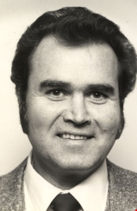
Alderman Frederick G. Randall
https://search.heritageburnaby.ca/link/archivedescription45119
- Repository
- City of Burnaby Archives
- Date
- [1979]
- Collection/Fonds
- Columbian Newspaper collection
- Description Level
- Item
- Physical Description
- 1 photograph : b&w ; 7.5 x 5 cm
- Scope and Content
- Photograph of Frederick George Randall, when he was a Burnaby Citizen's Association Alderman. He served as an Alderman from 1976 to 1981 and again from 1987 to 1990.
- Repository
- City of Burnaby Archives
- Date
- [1979]
- Collection/Fonds
- Columbian Newspaper collection
- Physical Description
- 1 photograph : b&w ; 7.5 x 5 cm
- Description Level
- Item
- Record No.
- 480-015
- Access Restriction
- No restrictions
- Reproduction Restriction
- Reproduce for fair dealing purposes only
- Accession Number
- 2003-02
- Scope and Content
- Photograph of Frederick George Randall, when he was a Burnaby Citizen's Association Alderman. He served as an Alderman from 1976 to 1981 and again from 1987 to 1990.
- Subjects
- Government - Provincial Government
- Media Type
- Photograph
- Notes
- Title based on contents of photograph
Images
![Alderman Frederick G. Randall, [1979] thumbnail](/media/hpo/_Data/_Archives_Images/_Unrestricted/480/480-015.jpg)
![Alderman Frederick G. Randall, [1979 or 1980] thumbnail](/media/hpo/_Data/_Archives_Images/_Unrestricted/480/480-016.jpg?width=280)
Alderman Frederick G. Randall
https://search.heritageburnaby.ca/link/archivedescription45120
- Repository
- City of Burnaby Archives
- Date
- [1979 or 1980]
- Collection/Fonds
- Columbian Newspaper collection
- Description Level
- Item
- Physical Description
- 1 photograph : b&w ; 17 x 11.5 cm
- Scope and Content
- Photograph of Frederick George Randall, during the time that he was a Burnaby Citizen's Association Alderman. In this photograph, he is gesturing with his arms during a speech. He served as an Alderman from 1976 to 1981 and again from 1987 to 1990.
- Repository
- City of Burnaby Archives
- Date
- [1979 or 1980]
- Collection/Fonds
- Columbian Newspaper collection
- Physical Description
- 1 photograph : b&w ; 17 x 11.5 cm
- Description Level
- Item
- Record No.
- 480-016
- Access Restriction
- No restrictions
- Reproduction Restriction
- No restrictions
- Accession Number
- 2003-02
- Scope and Content
- Photograph of Frederick George Randall, during the time that he was a Burnaby Citizen's Association Alderman. In this photograph, he is gesturing with his arms during a speech. He served as an Alderman from 1976 to 1981 and again from 1987 to 1990.
- Subjects
- Government - Provincial Government
- Media Type
- Photograph
- Photographer
- Battistoni, Peter
- Notes
- Title based on contents of photograph
Images
![Alderman Frederick G. Randall, [1979 or 1980] thumbnail](/media/hpo/_Data/_Archives_Images/_Unrestricted/480/480-016.jpg)
Alderman Frederick G. Randall
https://search.heritageburnaby.ca/link/archivedescription45123
- Repository
- City of Burnaby Archives
- Date
- March 1977
- Collection/Fonds
- Columbian Newspaper collection
- Description Level
- Item
- Physical Description
- 1 photograph : b&w ; 7.5 x 5 cm
- Scope and Content
- Photograph of Frederick George Randall when he was a Burnaby Citizen's Association Alderman. He served as an Alderman from 1976 to 1981 and again from 1987 to 1990.
- Repository
- City of Burnaby Archives
- Date
- March 1977
- Collection/Fonds
- Columbian Newspaper collection
- Physical Description
- 1 photograph : b&w ; 7.5 x 5 cm
- Description Level
- Item
- Record No.
- 480-019
- Access Restriction
- No restrictions
- Reproduction Restriction
- Reproduce for fair dealing purposes only
- Accession Number
- 2003-02
- Scope and Content
- Photograph of Frederick George Randall when he was a Burnaby Citizen's Association Alderman. He served as an Alderman from 1976 to 1981 and again from 1987 to 1990.
- Subjects
- Government - Provincial Government
- Media Type
- Photograph
- Notes
- Title based on contents of photograph
Images
