Narrow Results By
Subject
- Animals - Dogs 2
- Buildings - Recreational - Community Halls 3
- Buildings - Schools 2
- Ceremonies - Weddings 1
- Clothing - Uniforms 1
- Construction 3
- Documentary Artifacts - Certificates 3
- Geographic Features - Creeks 1
- Geographic Features - Lakes and Ponds 1
- Geographic Features - Roads 1
- Government - Federal Government 1
- Government - Local Government 2

Lozells Neighbourhood
https://search.heritageburnaby.ca/link/landmark701
- Repository
- Burnaby Heritage Planning
- Associated Dates
- 1925-1954
- Heritage Value
- Like a lot of residential neighbourhoods in Burnaby during the post-War boom, the Lozells area during the 1925-1954 period was one of new construction and subdivisions. Although more homes were being built, the neighbourhood still retained a somewhat rural characteristic well into the 1950s.
- Historic Neighbourhood
- Lozells (Historic Neighbourhood)
- Planning Study Area
- Government Road Area
Images


Lozells Neighbourhood
https://search.heritageburnaby.ca/link/landmark756
- Repository
- Burnaby Heritage Planning
- Associated Dates
- 1905-1924
- Heritage Value
- In 1906 C.T. Piper and Alfred Wiggs built a sawmill at the foot of what is now Piper Avenue along the north shore of Burnaby Lake. These operations and the proximity of the Great Northern Railway encourage settlers to move into this area and among them were Colonel and Mrs. James Ward. They were authorized to open a post office here and Mrs. Ward named it 'Lozells' after the Anglican parish to which she had been a member in Birmingham, England.
- Historic Neighbourhood
- Lozells (Historic Neighbourhood)
- Planning Study Area
- Government Road Area
Images


Family and political photograph album
https://search.heritageburnaby.ca/link/museumdescription3654
- Repository
- Burnaby Village Museum
- Date
- 1914-1977
- Collection/Fonds
- Harold Edward Winch collection
- Description Level
- Item
- Physical Description
- 1 album (ca. 85 photographs)
- Scope and Content
- Item is a photograph album containing ca. 85 photographs, including both personal and work-related subjects such as the Winch family and homes, and Winch's political work and travels. Also included are some textual records relating to Winch's political work.
- Repository
- Burnaby Village Museum
- Collection/Fonds
- Harold Edward Winch collection
- Description Level
- Item
- Physical Description
- 1 album (ca. 85 photographs)
- Scope and Content
- Item is a photograph album containing ca. 85 photographs, including both personal and work-related subjects such as the Winch family and homes, and Winch's political work and travels. Also included are some textual records relating to Winch's political work.
- Names
- Winch, Harold Edward
- Winch, Linda Marian Hendy
- Winch, Grace
- Winch, Eileen
- Winch, Ernest "Ernie"
- Winch, Eric
- Co-operative Commonwealth Federation "CCF"
- New Democratic Party
- Douglas, Tommy
- MacInnis, Grace
- Accession Code
- BV013.12.11
- Date
- 1914-1977
- Media Type
- Photograph
- Textual Record
- Notes
- Title based on contents of photograph
- A selection of photographs from scrapbook have been described at item level (BV013.12.36 to BV015.35.117)
Images

Documents

Central Park Neighbourhood
https://search.heritageburnaby.ca/link/landmark723
- Repository
- Burnaby Heritage Planning
- Associated Dates
- 1891-1904
- Heritage Value
- Central Park was one of the first and fastest-growing communities in Burnaby. Located along the electric tram line and the Vancouver Road (Kingsway), it was also chosen for a government settlement project referred to as the Central Park Small Holdings. The lands held by the Provincial Government were subdivided and sold around 1894 and by 1899 the settlement was large enough to warrant the construction of an Anglican Church there.
- Historic Neighbourhood
- Central Park (Historic Neighbourhood)
- Planning Study Area
- Maywood Area
Images

Government Road
https://search.heritageburnaby.ca/link/archivedescription35569
- Repository
- City of Burnaby Archives
- Date
- 1925 (date of original), copied 1986
- Collection/Fonds
- Burnaby Historical Society fonds
- Description Level
- Item
- Physical Description
- 1 photograph : b&w ; 12.7 x 17.8 cm print
- Scope and Content
- Photograph of Government Road in front of the Haddon family house at 7870 Government Road. Note the bushland and rough road surface.
- Repository
- City of Burnaby Archives
- Date
- 1925 (date of original), copied 1986
- Collection/Fonds
- Burnaby Historical Society fonds
- Subseries
- Pioneer Tales subseries
- Physical Description
- 1 photograph : b&w ; 12.7 x 17.8 cm print
- Description Level
- Item
- Record No.
- 204-427
- Access Restriction
- No restrictions
- Reproduction Restriction
- No known restrictions
- Accession Number
- BHS1988-03
- Scope and Content
- Photograph of Government Road in front of the Haddon family house at 7870 Government Road. Note the bushland and rough road surface.
- Subjects
- Geographic Features - Roads
- Media Type
- Photograph
- Notes
- Title based on contents of photograph
- Geographic Access
- Government Road
- Historic Neighbourhood
- Lozells (Historic Neighbourhood)
- Planning Study Area
- Government Road Area
Images

Broadview Neighbourhood
https://search.heritageburnaby.ca/link/landmark750
- Repository
- Burnaby Heritage Planning
- Associated Dates
- 1905-1924
- Heritage Value
- Between 1905 and 1924, the Broadview neighbourhood in Burnaby was settled by almost 100 families who saw the advantage of living in an area that was served by two railway lines - the B.C. Electric Railway and the Great Northern Railway. Touted as being only a 20 minute car ride to the city centre, this neighbourhood expanded during the early 1920s with the promise of a new direct access road to the city being built by the Great Northern Railway company and new blocks being opened up on two government reserves adjoining it.
- Historic Neighbourhood
- Broadview (Historic Neighbourhood)
- Planning Study Area
- Cascade-Schou Area
Images


Burnaby Civic Employees Union Memorial Fountain
https://search.heritageburnaby.ca/link/landmark539
- Repository
- Burnaby Heritage Planning
- Description
- This memorial granite drinking fountain is a monument to Burnaby’s municipal employees who lost their lives in the First World War. It has been relocated from its original setting to a shaded arterial pathway within the Burnaby Village Museum.
- Associated Dates
- 1923
- Formal Recognition
- Heritage Designation, Community Heritage Register
- Repository
- Burnaby Heritage Planning
- Geographic Access
- Deer Lake Avenue
- Associated Dates
- 1923
- Formal Recognition
- Heritage Designation, Community Heritage Register
- Enactment Type
- Bylaw No. 9807
- Enactment Date
- 23/11/1992
- Description
- This memorial granite drinking fountain is a monument to Burnaby’s municipal employees who lost their lives in the First World War. It has been relocated from its original setting to a shaded arterial pathway within the Burnaby Village Museum.
- Heritage Value
- The fountain is an early civic monument with superior massing and detail, constructed of local materials by local stonemason William Williamson. It was erected by the Burnaby Civic Employees Union (now CUPE Local 23) in 1923, on Burnaby’s original Municipal Hall grounds located at Kingsway and Edmonds Street, to honour their members who lost their lives in the First World War, commemorated by an engraved memorial at the top of the fountain. It signifies an important connection with the early strength and prominence of the civic labour union in Burnaby, as this was a memorial erected by the union members themselves, rather than by the civic government. Many war memorials were constructed across Canada after the end of the First World War, however, most are static, inviting passive contemplation. This memorial is unusual in its combination of functions; its use as a drinking fountain invites active participation. The memorial also includes a stone drinking bowl for dogs at the bottom left of the memorial, further illustrating the daily functional use of the fountain. The heritage value for this fountain also lies in its interpretive value within the Burnaby Village Museum. The site is an important cultural feature for the interpretation of Burnaby’s heritage to the public. The fountain was moved to the Burnaby Village Museum in 1974.
- Defining Elements
- The character defining features of the Burnaby Civic Employees Union Memorial Fountain include its: - distinctive form with central water fountain - construction of rough-dressed local B.C. granite - engraved memorial at the top - carved emblematic maple leaf - drinking fountain function - dog drinking bowl
- Locality
- Deer Lake Park
- Historic Neighbourhood
- Burnaby Lake (Historic Neighbourhood)
- Planning Study Area
- Morley-Buckingham Area
- Builder
- William Williamson
- Function
- Primary Current--Monument
- Primary Historic--Monument
- Secondary Current--Museum
- Community
- Burnaby
- Cadastral Identifier
- P.I.D. No. 011-030-356 Legal Description: Parcel 1, District Lot 79 and District Lot 85, Group 1, New Westminster District, Reference Plan 77594
- Boundaries
- Burnaby Village Museum is comprised of a single municipally-owned property located at 6501 Deer Lake Avenue, Burnaby.
- Area
- 38,488.63
- Contributing Resource
- Building
- Structure
- Landscape Feature
- Ownership
- Public (local)
- Documentation
- Heritage Site Files: PC77000 20. City of Burnaby Planning and Building Department, 4949 Canada Way, Burnaby, B.C., V5G 1M2
- Street Address
- 6501 Deer Lake Avenue
Images


Central Park
https://search.heritageburnaby.ca/link/landmark728
- Repository
- Burnaby Heritage Planning
- Geographic Access
- Imperial Street
- Associated Dates
- 1891
- Heritage Value
- In 1860, as the Royal Engineers constructed the road from New Westminster to Vancouver (now Kingsway), a military reserve was set aside at the trail's highest point along the ridge. This reserve provided a particularly good scenic look-out since the original forest had burned down prior to 1860, the remaining stumps offered unobstructed views. By the 1880s, the city council of both New Westminster and Vancouver eyed the reserve as potential recreation ground. As construction of the tram line was underway, the Provincial Government moved to designate the whole reserve as a park. On January 14, 1891, the Lieutenant Governor of British Columbia proclaimed it as a public recreation ground.
- Historic Neighbourhood
- Central Park (Historic Neighbourhood)
- Planning Study Area
- Maywood Area
- Street Address
- 3883 Imperial Street
- Street View URL
- Google Maps Street View
Images


East Burnaby School (Edmonds Street School)
https://search.heritageburnaby.ca/link/landmark735
- Repository
- Burnaby Heritage Planning
- Geographic Access
- Canada Way
- Associated Dates
- 1894
- Heritage Value
- One of the first tasks of Burnaby's Municipal Government upon its incorporation was to lobby for a public school in Burnaby. By 1893, land on Douglas Road near Edmonds was donated and the new school was built in 1893. The one-room school opened on January 22, 1894 with 29 students under the charge of teacher, Ethel LePage. The School has been known as the Burnaby School (until1896), and then East Burnaby School from 1896 to 1907 and finally, Edmonds Street School.
- Historic Neighbourhood
- Edmonds (Historic Neighbourhood)
- Planning Study Area
- Edmonds Area
- Street Address
- 7376 Canada Way
- Street View URL
- Google Maps Street View
Images


Seaforth Schoolhouse
https://search.heritageburnaby.ca/link/landmark541
- Repository
- Burnaby Heritage Planning
- Description
- The Seaforth Schoolhouse is a one-storey wood-frame rectangular plan building with a projecting entry porch, located in the Burnaby Village Museum.
- Associated Dates
- 1922
- Formal Recognition
- Heritage Designation, Community Heritage Register
- Repository
- Burnaby Heritage Planning
- Geographic Access
- Deer Lake Avenue
- Associated Dates
- 1922
- Formal Recognition
- Heritage Designation, Community Heritage Register
- Enactment Type
- Bylaw No. 8148
- Enactment Date
- 03/01/1984
- Description
- The Seaforth Schoolhouse is a one-storey wood-frame rectangular plan building with a projecting entry porch, located in the Burnaby Village Museum.
- Heritage Value
- The heritage value of the Seaforth Schoolhouse lies in its representation of a one-room school once located in one of the city’s rural districts. The school was constructed due to the demand of increasing population after the First World War, in what was then known as the Lozells District, so isolated at the time that parents were concerned about the danger to their children from wild bears and cougars that roamed the area. The school was named after its sponsor, the Seaforth Chapter of the Imperial Order of Daughters of the Empire. Bowman and Cullerne, the architects for the Burnaby School Board, designed the one room schoolhouse. It was constructed by local contractor, Alphonse J. Toebaert, following the standards of British Columbia public school architecture, which specified the plan and orientation of the building. It indicates the values and the design control of school boards of the time, and the central role of the provincial government in setting educational standards. The heritage value of this school also lies in its interpretive value within the Burnaby Village Museum. The site is an important cultural feature for the interpretation of Burnaby’s heritage to the public, illustrating the changes in the local school system over time. The school was moved to Burnaby Village Museum in 1983, and was opened to the public after extensive restoration in 1987. Both the interior and exterior have been restored and interpreted to the date of original construction. The North Vancouver School Board donated most of the early desks, and the remainder of the interior artifacts are from the museum’s own collection.
- Defining Elements
- Key elements that define the heritage character of the Seaforth Schoolhouse include its: - rectangular plan - hipped roof with cedar shingle cladding - hipped-roof entry porch - typical school fenestration of the era, with a bank of double-hung 6-over-6 wooden-sash windows on one facade - cedar shingle cladding - original and authentic interior elements such as interior mouldings, blackboards and desks
- Locality
- Deer Lake Park
- Historic Neighbourhood
- Burnaby Lake (Historic Neighbourhood)
- Planning Study Area
- Morley-Buckingham Area
- Organization
- Seaforth Chapter of the Imperial Order of Daughters of the Empire
- Burnaby School Board
- Burnaby Village Museum
- Architect
- Bowman and Cullerne
- Builder
- Alphonse J. Toebaert
- Function
- Primary Historic--One-Room School
- Primary Current--Museum
- Community
- Burnaby
- Cadastral Identifier
- P.I.D. No. 011-030-356 Legal Description: Parcel 1, District Lot 79 and District Lot 85, Group 1, New Westminster District, Reference Plan 77594
- Boundaries
- Burnaby Village Museum is comprised of a single municipally-owned property located at 6501 Deer Lake Avenue, Burnaby.
- Area
- 38,488.63
- Contributing Resource
- Building
- Landscape Feature
- Structure
- Ownership
- Public (local)
- Documentation
- Heritage Site Files: PC77000 20. City of Burnaby Planning and Building Department, 4949 Canada Way, Burnaby, B.C., V5G 1M2
- Street Address
- 6501 Deer Lake Avenue
Images


Certificate of Canadian Citizenship issued to Quon Lip Lee
https://search.heritageburnaby.ca/link/museumdescription16718
- Repository
- Burnaby Village Museum
- Date
- 6 Oct. 1966
- Collection/Fonds
- Quon Lip Lee fonds
- Description Level
- Item
- Physical Description
- 1 photograph (tiff)
- Scope and Content
- Item consists of a Certificate of Canadian Citizenship issued to Quon Lip Lee on October 6, 1966. The back of the certificate includes vitial information including date of birth, marital status and date of issue.
- Repository
- Burnaby Village Museum
- Collection/Fonds
- Quon Lip Lee fonds
- Description Level
- Item
- Physical Description
- 1 photograph (tiff)
- Scope and Content
- Item consists of a Certificate of Canadian Citizenship issued to Quon Lip Lee on October 6, 1966. The back of the certificate includes vitial information including date of birth, marital status and date of issue.
- Creator
- Government of Canada
- Names
- Lee, Quon Lip
- Accession Code
- BV021.18.2
- Access Restriction
- No restrictions
- Reproduction Restriction
- May be restricted by third party rights
- Date
- 6 Oct. 1966
- Media Type
- Textual Record
- Photograph
- Scan Resolution
- 600
- Scan Date
- April 8, 2021
- Scale
- 100
- Notes
- Title based on contents of item
Images


Head tax certificate issued to Dung Way How
https://search.heritageburnaby.ca/link/museumdescription15546
- Repository
- Burnaby Village Museum
- Date
- 1922-1934 (date of original), copied 2021
- Collection/Fonds
- Burnaby Village Museum Document collection
- Description Level
- Item
- Physical Description
- 1 certificate (tiff) : col. ; 600 dpi
- Scope and Content
- Item consists of a head tax certificate issued by the Dominion of Canada - Immigration Branch - Department of the Interior to Dung Way How (Dong Howe). The certificate was first issued on March 18, 1922 and includes certification stamps on the front along with a photograph of Dung Way How. Certifi…
- Repository
- Burnaby Village Museum
- Collection/Fonds
- Burnaby Village Museum Document collection
- Description Level
- Item
- Physical Description
- 1 certificate (tiff) : col. ; 600 dpi
- Scope and Content
- Item consists of a head tax certificate issued by the Dominion of Canada - Immigration Branch - Department of the Interior to Dung Way How (Dong Howe). The certificate was first issued on March 18, 1922 and includes certification stamps on the front along with a photograph of Dung Way How. Certification stamps on the verso of the certificate were issued by Chinese Immigration authorities between 1922 and 1934. Information on the front of the certificate reads "...This Certifies That / Dung Way How whose photograph is attached / hereto arrived or landed at Vancouver B.C. / on the 23rd day of January 1922 / ex "Empress of Asia" / and upon representations made has been / admitted as exempt from head tax under the / provisions of the Chinese Immigration Act. / The above mentioned party claims / to be a native of Bark Choon Jong in the District of Pon Yue of the age of 20 years. The declaration in this case is C.I.4. No. 3715 Date at Vancouver on March 18, 1922" signed by "Controller of Chinese Immigration". Printed text on verso of certificate reads "IMPORTANT / IT IS NECESSARY THAT THIS / CERTIFICATE BE CAREFULLY / PRESERVED AS IT IS OF VALUE / AS A MEANS OF IDENTIFICATION".
- History
- Dung Way How (Dong Howe) arrived from Bak Chun (North Village), Guangdong in 1922 as a paper son. He had two sons during his first marriage, but the sons remained in China and one died at a young age. He married his second wife Chow Goon Pang through an arranged marriage. She was married twice previously and had a son from each marriage, but neither of them survived. Chow was from Nam Chun (South Village) and arrived in Canada as a paper daughter around the late 1930s or early 1940s. Both Dong and Chow spoke a Poon Yue dialect. The couple raised one daughter Vivian Dong (Dong Jing Yu) in Canada. The Dong family leased and operated the New Fountain hotel in Vancouver located at Abbott Street and Cordova Street. The family later went on to purchase farmland in Burnaby in 1957. The Dong family moved to Burnaby and operated a three acre market garden located at 6220 14th Avenue until 1972. They grew European staples including celery, radishes, green onions, beets, lettuces, endives, as well as Chinese vegetables such as gai lan (Chinese broccoli). There were two Chinese families in the area, including the Wong family who operated the Wong Chew market gardens 6325 14th Avenue. Dong Howe passed away in 1978. Chow Goon Pang passed away in 2000. Their daughter Vivian grew up in Burnaby and attended Riverside Elementary, McPherson Junior High School and Burnaby South Secondary School.
- Creator
- Government of Canada
- Names
- Howe, Dong
- Accession Code
- BV021.13.1
- Access Restriction
- No restrictions
- Reproduction Restriction
- No known restrictions
- Date
- 1922-1934 (date of original), copied 2021
- Media Type
- Textual Record
- Photograph
- Scan Resolution
- 600
- Scan Date
- March 25, 2021
- Scale
- 100
- Notes
- Title based on contents of photograph
Images


![Head tax certificate issued to Lee Quon Lep [Quan Lip Lee], 1921-1949 (date of original), copied 2021 thumbnail](/media/hpo/_Data/_BVM_Textual_Records/2021/2021_0018_0001_001.jpg?width=280)
Head tax certificate issued to Lee Quon Lep [Quan Lip Lee]
https://search.heritageburnaby.ca/link/museumdescription16717
- Repository
- Burnaby Village Museum
- Date
- 1921-1949 (date of original), copied 2021
- Collection/Fonds
- Quon Lip Lee fonds
- Description Level
- Item
- Physical Description
- 1 photograph (tiff)
- Scope and Content
- Item consists of a head tax certificate issued by the Dominion of Canada - Immigration Branch - Department of the (Interior) issued to Lee Quon Lep [sic] [Quon Lip Lee]. The certificate was first issued on December 12, 1921 and includes certification stamps on the front along with a photograph of Q…
- Repository
- Burnaby Village Museum
- Collection/Fonds
- Quon Lip Lee fonds
- Description Level
- Item
- Physical Description
- 1 photograph (tiff)
- Scope and Content
- Item consists of a head tax certificate issued by the Dominion of Canada - Immigration Branch - Department of the (Interior) issued to Lee Quon Lep [sic] [Quon Lip Lee]. The certificate was first issued on December 12, 1921 and includes certification stamps on the front along with a photograph of Quan Lip Lee. Certification stamps on the verso of the certificate were issued by Canadian and Chinese Immigration authorities between 1924 and 1949. Information on the front of the certificate reads "DOMINION OF CANADA / IMMIGRATION BRANCH - DEPARTMENT.../ RECEIVED FRO.../ Lee Quon Lep whose photograph is attached / hereto on the date and at the place hereunder mentioned the sum / of five Hundred Dollars being the head tax due under the / provisions of the Chinese Immigration Act. / The above mentioned party claims / to be a native of Gong Doey Lee / in the district of Sun Way / of the age of 12 years arrived or landed / at Vancouver on the 28th day of / November 1921 ex Empress [sic] of Asia / The declaration in this case is C.I.4 No. 3716 / Dated at Vancouver on Dec 12, 1921_19_/ (signature) / CONTROLLER OF CHINESE IMMIGRATION". Printed text on verso of certificate reads "IMPORTANT / IT IS NECESSARY THAT THIS / CERTIFICATE BE CAREFULLY / PRESERVED AS IT IS OF VALUE / AS A MEANS OF IDENTIFICATION" along with Chinese language characters printed vertically below.
- Creator
- Government of Canada
- Names
- Lee, Quon Lip
- Accession Code
- BV021.18.1
- Access Restriction
- No restrictions
- Reproduction Restriction
- No known restrictions
- Date
- 1921-1949 (date of original), copied 2021
- Media Type
- Textual Record
- Photograph
- Scan Resolution
- 600
- Scan Date
- April 8, 2021
- Scale
- 100
- Notes
- Title based on contents of item
Images
![Head tax certificate issued to Lee Quon Lep [Quan Lip Lee], 1921-1949 (date of original), copied 2021 thumbnail](/media/hpo/_Data/_BVM_Textual_Records/2021/2021_0018_0001_001.jpg)


Map of South Western Part of British Columbia
https://search.heritageburnaby.ca/link/museumdescription8688
- Repository
- Burnaby Village Museum
- Date
- 1897
- Collection/Fonds
- Burnaby Village Museum Map collection
- Description Level
- Item
- Physical Description
- 1 map : col. ink on paper ; 68 x 88 cm
- Scope and Content
- Item consists of a "MAP OF THE SOUTH-WESTERN PART OF BRITISH COLUMBIA”. Map identifies geographic land districts of New Westminster District; Coast District; Lillooet District; Yale District, Kamloops Division, Yale Division and districts on Vancouver Island. Map also includes the northern portions…
- Repository
- Burnaby Village Museum
- Collection/Fonds
- Burnaby Village Museum Map collection
- Description Level
- Item
- Physical Description
- 1 map : col. ink on paper ; 68 x 88 cm
- Material Details
- Scale [1:633600]
- Scope and Content
- Item consists of a "MAP OF THE SOUTH-WESTERN PART OF BRITISH COLUMBIA”. Map identifies geographic land districts of New Westminster District; Coast District; Lillooet District; Yale District, Kamloops Division, Yale Division and districts on Vancouver Island. Map also includes the northern portions of the State of Washington below the 49th parallel.
- Publisher
- The Colonist Litho Victoria B.C.
- Responsibility
- Martin, George Bohun
- Accession Code
- BV993.12.12
- Access Restriction
- No restrictions
- Reproduction Restriction
- No known restrictions
- Date
- 1897
- Media Type
- Cartographic Material
- Scan Resolution
- 600
- Scan Date
- 2023-08-17
- Notes
- Transcribed title
- Scale equals 1 inch to 10 miles
- "Compiled and drawn by direction of the Honouable G.B. Martin, Chief Commissioner of Lands and Works, Victoria, B.C."
- Signed by Surveyor General "Tom Kains"
Zoomable Images


Subdivision plans in New Westminster District Group 1 – Burnaby, Vancouver and map - Canada Department of Mines
https://search.heritageburnaby.ca/link/museumdescription6994
- Repository
- Burnaby Village Museum
- Date
- 1890-1909
- Collection/Fonds
- Burnaby Village Museum Map collection
- Description Level
- File
- Physical Description
- 1 plan : graphite on paper + 2 plans : black ink on paper + 1 map : col. on paper mounted on 2 sides of cardboard 76 x 102 cm
- Scope and Content
- Item consists of a large board with one New Westminster District subdivision plan mounted on one side and two New Westminster District subdivision plans and one colour map mounted on the other side. Side A: 1. "Plan / of Subdivision of / Blocks 2, 3, 4, 5, 6 / Lot 77 / Group 1 / New Westminster D…
- Repository
- Burnaby Village Museum
- Collection/Fonds
- Burnaby Village Museum Map collection
- Description Level
- File
- Physical Description
- 1 plan : graphite on paper + 2 plans : black ink on paper + 1 map : col. on paper mounted on 2 sides of cardboard 76 x 102 cm
- Material Details
- Scales 1:720 and 1:1200 and 1:.00001578
- Scope and Content
- Item consists of a large board with one New Westminster District subdivision plan mounted on one side and two New Westminster District subdivision plans and one colour map mounted on the other side. Side A: 1. "Plan / of Subdivision of / Blocks 2, 3, 4, 5, 6 / Lot 77 / Group 1 / New Westminster District / BC. / Scale 100 feet = 1 inch", "Deposited 8th day / of April 1890 / Mowileg [sic] / Dist. Regt". Plan is drawn in graphite with annotations: "AB_Parts_lettered_are_lots_in / the_different_subdivisions" / "Owners: / James E. Hall / P.S.Cabilan [sic] by his attorney Joseph Hall / Joseph Hall / Eliza J. Shannon / John Harrison"; "This plan is correct and is prepared under the / provisions of the Land Registry Act" ; signed by: "Gordon Herman & Burwell / Dominion & Provincial Land Surveryors / Vancouver March 19th/90" . Plan is initialed by: "RB" [sic] (in blue pencil crayon) and measures: 99.5 x 65 cm (Geographic location: Burnaby) Side B: 1. Map titled "Canada / Department of Mines / Geological Survey Branch" / "Hon.W Templeton, Minister / A.P. Low, Deputy Minister / R.W. Brock, Acting Director", Vol. XXXI, Plate I / Compiled under the direction of / James White, F.R.G.S. Geographer /Dep. of Interior". Note above map reads: "To illustrate Mr. James Barrowman's report as Delegate at the Excursion - meeting of the Canadian Mining Institute", "The instiitution of Mining Engineers / Transactions 1908 - 1909", "The Mining Institute of Scotland / Transactions 1908-1909". Map identifies minerals and includes a Legend and Scale: 100 miles = 1 inch 2. "Plan / of Subdivision of / Lot 4 / of Subdivision of / Lot 87. Gr. 1 / New Westminster District / Scale 60' = 1in." Plan is initialed by: "RB" [sic] along with a note "also Board / 48" (in blue pencil crayon) (Geographic location: Burnaby) 3. Plan of "Lot 335 / G. 1" west of Boundary Road and north of River Road - Vancouver. (Geographic location: Vancouver)
- Publisher
- The Mining Institute of Scotland
- Geographic Access
- Vancouver
- Accession Code
- HV977.93.25
- Access Restriction
- No restrictions
- Reproduction Restriction
- No known restrictions
- Date
- 1890-1909
- Media Type
- Cartographic Material
- Scan Resolution
- 300
- Scale
- 72
- Notes
- Title based on contents of file
- Scale is measured in feet and miles.
- The term "Lot" often refers to "District Lot"
Images


![B.C. Parliament Building in Victoria, [ca. 1920] thumbnail](/media/hpo/_Data/_BVM_Images/1985/1985_5899_0003_001.jpg?width=280)
B.C. Parliament Building in Victoria
https://search.heritageburnaby.ca/link/museumdescription1527
- Repository
- Burnaby Village Museum
- Date
- [ca. 1920]
- Collection/Fonds
- Burnaby Village Museum Photograph collection
- Description Level
- Item
- Physical Description
- 1 photograph : b&w ; 6.5 x 9 cm
- Scope and Content
- Photograph of the British Columbia Parliament Buildings, home of the Legislative Assembly of British Columbia located in Victoria. There are people standing on the steps to the front entrance. There is a sign on the lawn in front of the parliament buliding that reads, "PLEASE KEEP OFF THE GRASS."
- Repository
- Burnaby Village Museum
- Collection/Fonds
- Burnaby Village Museum Photograph collection
- Description Level
- Item
- Physical Description
- 1 photograph : b&w ; 6.5 x 9 cm
- Material Details
- stamped on verso, t. "159"
- Scope and Content
- Photograph of the British Columbia Parliament Buildings, home of the Legislative Assembly of British Columbia located in Victoria. There are people standing on the steps to the front entrance. There is a sign on the lawn in front of the parliament buliding that reads, "PLEASE KEEP OFF THE GRASS."
- Subjects
- Government - Provincial Government
- Geographic Access
- Victoria
- Accession Code
- BV985.5899.3
- Access Restriction
- No restrictions
- Reproduction Restriction
- No known restrictions
- Date
- [ca. 1920]
- Media Type
- Photograph
- Scan Resolution
- 600
- Scan Date
- 2024-02-27
- Notes
- Title based on contents of photograph
Images
![B.C. Parliament Building in Victoria, [ca. 1920] thumbnail](/media/hpo/_Data/_BVM_Images/1985/1985_5899_0003_001.jpg)
![Charles Boyer Brown, by photographer Nicholas Rossmo [1950]. Item no. 307-008 thumbnail](/media/hpo/_Data/_Archives_Images/_Unrestricted/251/307-008.jpg?width=280)
Interview with Charles B. Brown May 21, 1975 - Track 8
https://search.heritageburnaby.ca/link/oralhistory34
- Repository
- City of Burnaby Archives
- Date Range
- 1928-1945
- Length
- 0:06:03
- Summary
- This portion of the interview pertains to Charles Boyer Brown's experiences with tax sales and a description of how they functioned.
- Repository
- City of Burnaby Archives
- Summary
- This portion of the interview pertains to Charles Boyer Brown's experiences with tax sales and a description of how they functioned.
- Date Range
- 1928-1945
- Photo Info
- Charles Boyer Brown, by photographer Nicholas Rossmo [1950]. Item no. 307-008
- Length
- 0:06:03
- Subjects
- Government - Local Government
- Interviewer
- Bradbury, Dr. Bettina
- Interview Date
- May 21, 1975
- Scope and Content
- Recording is a taped interview with Charles B. Brown by SFU (Simon Fraser University) graduate student Bettina Bradbury May 21, 1975. Major themes discussed are: the Depression, the Commissioner and municipal politics in general. To view "Narrow By" terms for each track expand this description and see "Notes".
- Biographical Notes
- Charles Boyer Brown was born on June 16, 1894 in the town of Ongar, Essex, England. He came to Canada as a young child with his parents Jean and Percy Brown. In 1903, the family settled in New Westminster and by 1911, Charles had joined the Burnaby municipal staff working as an office boy. The outbreak of World War One interrupted Charlie’s career as he immediately enlisted with the Royal Engineers and served from 1915 to 1918. While overseas he met and married Lillian Bernice Bryan and they returned to Canada together after the war and Charles resumed his position in municipal administration. For a short time, Charles was appointed as the Municipal Assessor, but in 1927 he became the Assistant Municipal Clerk. In 1933, Charles was made Municipal Clerk, a post he held until he retired in 1959. Charles has also been credited with playing a significant role in administering the city while it was under the rule of the provincial commission from 1932-1942. Recognized for his expertise in civic affairs, Charles was appointed by the provincial government to a committee formed to review and revise the Municipal Act. He was also a member of the BC Municipal Officers’ Association from its formation in 1936 and was made its chair in 1953. While these civic duties occupied much of his time, Charles still managed to participate as a volunteer on many sport and youth clubs in the city and served as the secretary for the Kingsway Rotary Club. In recognition of his outstanding contributions to Burnaby, both paid and volunteer, Charles was presented with the Gold Key award in 1959, the same year he finally retired from municipal administration. During Charles’ lifetime, many changes took place in the Municipality that he loved. He saw Burnaby grow in population and progress and he could be proud of the significant part he played in that growth and development. Charles Brown died on August 11, 1981.
- Total Tracks
- 8
- Total Length
- 0:58:01
- Interviewee Name
- Brown, Charles B. "Charlie"
- Interview Location
- Walker Avenue
- Interviewer Bio
- Bettina Bradbury teaches history and women's studies at York University. She is the author of Wife to Widow. Lives, Laws and Politics in Nineteenth-century Montreal. (Vancouver: University of British Columbia Press, June 2011), 520p; Working Families. Age, Gender and Daily Survival in Industrializing Montreal. (Toronto: Canadian Social History Series, McClelland and Stewart, 1993); (Republished Toronto: Oxford University Press, 1996) (3rd edition, Toronto: University of Toronto Press, 2007). These interviews were undertaken after she completed her MA at Simon Fraser University in 1975 with the support of an LIP grant.
- Collection/Fonds
- Burnaby Historical Society fonds
- Subseries
- Oral history subseries
- Transcript Available
- None
- Media Type
- Sound Recording
- Web Notes
- Interview was digitized in 2010 allowing it to be accessible on Heritage Burnaby. The digitization project was initiated by the Community Heritage Commission with support from City of Burnaby Council and the BC History Digitization Program of the Irving K. Barber Learning Centre, University of British Columbia. It was recognized by the Heritage Society of BC with an award in 2012.
Images
![Charles Boyer Brown, by photographer Nicholas Rossmo [1950]. Item no. 307-008 thumbnail](/media/hpo/_Data/_Archives_Images/_Unrestricted/251/307-008.jpg)
Audio Tracks
Track eight of interview with Charles B. Brown
Track eight of interview with Charles B. Brown
https://search.heritageburnaby.ca/media/hpo/_Data/_Archives_Oral_Histories/_Unrestricted/100-13-06/100-13-06_Track_8.mp3![Kay Zimmerman, [1973]. Item no. 231-021 thumbnail](/media/hpo/_Data/_Archives_Images/_Unrestricted/205/231-021.jpg?width=280)
Interview with Kay Zimmerman by Rod Fowler [February] 1990 - Track 4
https://search.heritageburnaby.ca/link/oralhistory530
- Repository
- City of Burnaby Archives
- Date Range
- 1920-1990
- Length
- 00:07:37
- Summary
- This portion of the interview is about Burnaby growing from “a dreamy little community” with little business to transact in council, to a municipality providing many more services and planning for and supporting industrial, commercial and residential growth. She talks about the first malls at Brent…
- Repository
- City of Burnaby Archives
- Summary
- This portion of the interview is about Burnaby growing from “a dreamy little community” with little business to transact in council, to a municipality providing many more services and planning for and supporting industrial, commercial and residential growth. She talks about the first malls at Brentwood and Lougheed, the George Derby lands, and the return of Oakalla Prison lands to Burnaby.
- Date Range
- 1920-1990
- Photo Info
- Kay Zimmerman, [1973]. Item no. 231-021
- Length
- 00:07:37
- Interviewer
- Fowler, Rod
- Interview Date
- [February] 1990
- Scope and Content
- Recording is of an interview with Kay Zimmerman, conducted by Rod Fowler. Kay Zimmerman was one of eleven participants interviewed as part of the SFU/Burnaby Centennial Committee's oral history series titled, "Voices of Burnaby". The interview is mainly about Kay Zimmerman’s political activities in Burnaby and her description of her Lochdale neighbourhood in the 1960s. She provides an excellent overview of the municipal political groups and important political issues in Burnaby from 1960 to 1980. She tells the story about an early and successful political action that convinced her that an individual can make a difference. To view “Narrow By” terms for each track expand this description and see “Notes”.
- Biographical Notes
- Kathleen “Kay” Zimmerman, her husband Gordon and their young son Rick moved to Burnaby from Vancouver in 1960 to a house on Curtis Avenue near Duthie Street (a second son Bruce was born in Burnaby). Kay Zimmerman worked 12 years at Royal Columbian Hospital in the admitting office, then 4 years (1974-1979) as special assistant to Senator Ray Perrault, followed by work as a judge on the Citizenship Court before retiring. Gordon Zimmerman worked at the Shell Refinery. A member of the Liberal Party and political activist before arriving in Burnaby, Kay Zimmerman continued her involvement in national and local politics. She campaigned for Ray Perrault during the Trudeau years, and was a founder and active member of the Burnaby Voters Association (BVA). Her political activities encompassed 30 years that saw major changes in Burnaby, including the building of SFU, creation of Heritage Village, an awakening environmental sensibility, and a dramatic increase in population and development in Burnaby.
- Total Tracks
- 10
- Total Length
- 01:04:36
- Interviewee Name
- Zimmerman, Kay
- Interviewer Bio
- Rod Fowler returned to university as a mature student in the 1980s after working about twenty years in the field of economics and computerization in business in England, Europe and Western Canada. He graduated with a BA from SFU in both History and Sociology in 1987, his MA degree in Geography in 1989, and his PhD in Cultural Geography at SFU. He taught courses in Geography, Sociology, History and Canadian Studies at several Lower Mainland colleges, before becoming a full time member of the Geography Department at Kwantlen University College.
- Collection/Fonds
- SFU/Burnaby Centennial Committee fonds
- Transcript Available
- Transcript available
- Media Type
- Sound Recording
- Web Notes
- Interviews were digitized in 2015 allowing them to be accessible on Heritage Burnaby. The digitization project was initiated by the Community Heritage Commission with support from City of Burnaby Council.
Images
![Kay Zimmerman, [1973]. Item no. 231-021 thumbnail](/media/hpo/_Data/_Archives_Images/_Unrestricted/205/231-021.jpg)
Audio Tracks
Track four of interview with Kay Zimmerman
Track four of interview with Kay Zimmerman
https://search.heritageburnaby.ca/media/hpo/_Data/_Archives_Oral_Histories/_Unrestricted/MSS187-018/MSS187-018_Track_4.mp3
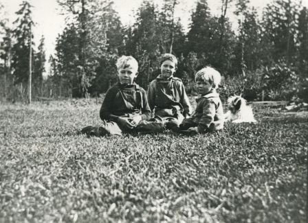
Haddon Family
https://search.heritageburnaby.ca/link/archivedescription35566
- Repository
- City of Burnaby Archives
- Date
- 1922 (date of original), copied 1986
- Collection/Fonds
- Burnaby Historical Society fonds
- Description Level
- Item
- Physical Description
- 1 photograph : b&w ; 12.7 x 17.8 cm print
- Scope and Content
- Photograph of Haddon family boys. Left to right: Gordon Haddon (brother), Jimmy Haddon (cousin), and Douglas Haddon (brother). This photo was taken looking south from behind the family home at 7870 Government Road between Lozells Avenue and Piper Avenue.
- Repository
- City of Burnaby Archives
- Date
- 1922 (date of original), copied 1986
- Collection/Fonds
- Burnaby Historical Society fonds
- Subseries
- Pioneer Tales subseries
- Physical Description
- 1 photograph : b&w ; 12.7 x 17.8 cm print
- Description Level
- Item
- Record No.
- 204-424
- Access Restriction
- No restrictions
- Reproduction Restriction
- No known restrictions
- Accession Number
- BHS1988-03
- Scope and Content
- Photograph of Haddon family boys. Left to right: Gordon Haddon (brother), Jimmy Haddon (cousin), and Douglas Haddon (brother). This photo was taken looking south from behind the family home at 7870 Government Road between Lozells Avenue and Piper Avenue.
- Subjects
- Animals - Dogs
- Media Type
- Photograph
- Notes
- Title based on contents of photograph
- Geographic Access
- Government Road
- Street Address
- 7870 Government Road
- Historic Neighbourhood
- Lozells (Historic Neighbourhood)
- Planning Study Area
- Government Road Area
Images

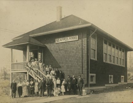
Opening day of Seaforth School in Burnaby
https://search.heritageburnaby.ca/link/archivedescription36608
- Repository
- City of Burnaby Archives
- Date
- 1922
- Collection/Fonds
- Burnaby Historical Society fonds
- Description Level
- Item
- Physical Description
- 1 photograph : sepia ; 18.5 x 23.5 cm (sight) in mat 30 x 35 cm
- Scope and Content
- Photograph of the official opening of Seaforth School on Government Road at Piper Avenue. Teachers, students, parents and staff are all standing on the steps of the school as well as in a long row out front. Individuals have been identified as; (from top of stairs) the school's first teacher Mrs. P…
- Repository
- City of Burnaby Archives
- Date
- 1922
- Collection/Fonds
- Burnaby Historical Society fonds
- Subseries
- J.P. Dickson subseries
- Physical Description
- 1 photograph : sepia ; 18.5 x 23.5 cm (sight) in mat 30 x 35 cm
- Description Level
- Item
- Record No.
- 308-001
- Access Restriction
- No restrictions
- Reproduction Restriction
- No known restrictions
- Accession Number
- BHS1992-51
- Scope and Content
- Photograph of the official opening of Seaforth School on Government Road at Piper Avenue. Teachers, students, parents and staff are all standing on the steps of the school as well as in a long row out front. Individuals have been identified as; (from top of stairs) the school's first teacher Mrs. Postill, (next step, left to right) [unidentified], Evelyn Jenkins, (next step) Dorothy Pipe, Myrtle Jackson, (next step) [unidentified], (next step) Beulah Tobaert, [unidentified], [unidentified], (next step) Madaleine Tobaert, Stewart Pipe, Arthur Haddon, (next step) [unidentified], [unidentified], Gordon Haddon, Russell Pipe, (next step) Jimmie Haddon, Douglas Haddon, George Johnston. Seated on the bottom steps are; unidentified and Douglas Haddon. Standing on the ground to the right of the seated boys are; (back row) [unidentified], [looks to be Claude Hill], [unidentified]. Standing in front of them are Kathleen Pipe, [unidentified] and Jack Jenkins. Standing on the ground to the left of the staircase are all unidentified except for the woman wearing a hat who has been identified as Mrs. Haddon (Myrtle and Jimmie's mom).The school building was later moved to Burnaby Village Museum.
- Subjects
- Occupations - Teachers
- Names
- Seaforth School
- Media Type
- Photograph
- Notes
- Title based on contents of photograph
- Item no. BV985.6022.2 is a laser copy of this original
- Individuals were identified from handwritten notes on recto of item BV985.6022.2 (laser copy of original)
- Geographic Access
- Government Road
- Deer Lake Avenue
- Street Address
- 7881 Government Road
- 6501 Deer Lake Avenue
- Historic Neighbourhood
- Lozells (Historic Neighbourhood)
- Planning Study Area
- Government Road Area
Images