Narrow Results By
Subject
- Advertising Medium - Signs and Signboards 2
- Aerial Photographs 1
- Agriculture - Farms 2
- Buildings - Agricultural - Nurseries 1
- Buildings - Commercial 5
- Buildings - Commercial - Offices 1
- Buildings - Industrial 2
- Buildings - Schools 1
- Construction 1
- Construction Tools and Equipment 2
- Education 1
- Emergency Services - Ambulance Services 1

Big Bend Neighbourhood
https://search.heritageburnaby.ca/link/landmark840
- Repository
- Burnaby Heritage Planning
- Associated Dates
- 1955-2008
- Heritage Value
- The Big Bend Neighbourhood in Burnaby maintained its status as an important agricultural area in the City in the years following 1955 and it also solidified its role as a prime industrial and commercial district. In 1972, the Big Bend Development Plan was adopted by Council and soon thereafter, approximately 620 acres of land were incorporated into the Agricultural Land Reserve. These lands have been set aside for agricultural and limited recreation purposes. By the 2000s, 160 acres of land were considered highly productive agricultural areas, and over 400 acres of land had been secured as parkland, including the Fraser Foreshore Park. The area also developed large commercial and industrial districts including those at Marine Way/Boundary, the Glenlyon Estates, Riverfront Business Park, Burnaby Business Park, and Glenwood Industrial Estates.
- Historic Neighbourhood
- Fraser Arm (Historic Neighbourhood)
- Planning Study Area
- Big Bend Area
Images


Riverside School
https://search.heritageburnaby.ca/link/landmark711
- Repository
- Burnaby Heritage Planning
- Geographic Access
- Marine Drive
- Associated Dates
- 1953-1983
- Heritage Value
- The south-east corner of Burnaby featured homes that were scattered in a rural setting. Previously, Riverway East and then Clinton Elementary School had served this neighbourhood, but a more central location was preferable to the School Board to limit bussing of students, so Riverside School was opened in 1953. There were 84 students registered in its first year, but by the late 1970s, enrolments across the City had declined and a number of schools, including Riverside, were closed.
- Historic Neighbourhood
- Fraser Arm (Historic Neighbourhood)
- Planning Study Area
- Big Bend Area
Images

106-7450 lowland [sic] dr
https://search.heritageburnaby.ca/link/archivedescription93811
- Repository
- City of Burnaby Archives
- Date
- September 1992
- Collection/Fonds
- Grover, Elliott & Co. Ltd. fonds
- Description Level
- File
- Physical Description
- 17 photographs : col. negative ; 35 mm
- Scope and Content
- Photographs of the exterior of a two-storey commercial building located 7450 Lowland Drive. Tenant businesses visible in the photographs include Dura-Log and Kango.
- Repository
- City of Burnaby Archives
- Date
- September 1992
- Collection/Fonds
- Grover, Elliott & Co. Ltd. fonds
- Physical Description
- 17 photographs : col. negative ; 35 mm
- Description Level
- File
- Record No.
- 622-059
- Access Restriction
- No restrictions
- Reproduction Restriction
- No restrictions
- Accession Number
- 2017-39
- Scope and Content
- Photographs of the exterior of a two-storey commercial building located 7450 Lowland Drive. Tenant businesses visible in the photographs include Dura-Log and Kango.
- Subjects
- Buildings - Commercial - Offices
- Media Type
- Photograph
- Notes
- Transcribed title
- Title transcribed from envelope photographs were originally housed in
- File no. 92-346-B
- Geographic Access
- Lowland Drive
- Street Address
- 7450 Lowland Drive
- Historic Neighbourhood
- Fraser Arm (Historic Neighbourhood)
- Planning Study Area
- Big Bend Area
5324 Thorne Ave
https://search.heritageburnaby.ca/link/archivedescription93762
- Repository
- City of Burnaby Archives
- Date
- June 12, 1992
- Collection/Fonds
- Grover, Elliott & Co. Ltd. fonds
- Description Level
- File
- Physical Description
- 120 photographs : col. negatives ; 35 mm
- Scope and Content
- Photographs of an industrial property located at 5324 Thorne Avenue - an address than no longer exists.
- Repository
- City of Burnaby Archives
- Date
- June 12, 1992
- Collection/Fonds
- Grover, Elliott & Co. Ltd. fonds
- Physical Description
- 120 photographs : col. negatives ; 35 mm
- Description Level
- File
- Record No.
- 622-047
- Access Restriction
- No restrictions
- Reproduction Restriction
- No restrictions
- Accession Number
- 2017-39
- Scope and Content
- Photographs of an industrial property located at 5324 Thorne Avenue - an address than no longer exists.
- Subjects
- Buildings - Industrial
- Media Type
- Photograph
- Notes
- Transcribed title
- Title transcribed from envelope photographs were originally housed in
- File no. 92-224-I
- Note adhered to 622-047-001 print reads: "11 / The manufacturing plant [illegible], southwest from the northweast corner of the site".
- Note adhered to 622-047-5 print reads: "17 / view south along the east side of the property from Thorne Avenue".
- Note adhered to 622-047-9 print reads: "18 / The canopy at loading area and shed addition of the [illegible] and of the building".
- Note adhered to 622-047-13 print reads: "19 / View of the interior of the building looking towards to west".
- Note adhered to 622-047-17 print reads: "23 / view east across the site immediately south of the building".
- Note adhered to 622-047-21 print reads: "22 / view looking north west twoards the south facade".
- Note adhered to 622-047-25 print reads: "8 / The freestanding office building adjacent to Thorne Avenue and Wiggins Street".
- Note adhered to 622-047-29 print reads: "9 / View of its front entr [sid] and the office building".
- Note adhered to 622-047-33 reads: "10 / View west towards the office building from the main vehicle entr [sic] at Thorne Avenue".
- Note adhered to 622-047-37 print reads: "14 / View east across the north yard area".
- Note adhered to 622-047-41 print reads: "12 / View of the north facade looking south."
- Note adhered to 622-047-45 print reads: "13 / View west across the north yard area".
- Note adhered to 622-047-49 print reads: "20 / The [illegible] building".
- Note adhered to 622-047-53 print reads: "26 / View northeast from the west property line".
- Note adhered to 622-047-57 print reads: "21 / View looking northeast at the south facade".
- Note adhered to 622-047-61 print reads: "16 / View north along the west side of the manufacturing building".
- Note adhered to 622-047-65 print reads: "15 / View of the north west corner of the manufacturing building".
- Note adhered to 622-047-69 print reads: "3 / View west along Thorne Avenue from the east side of the property".
- Note adhered to 622-047-73 print reads: "25 / View north from the southeast corner of the property".
- Note adhered to 622-047-77 print reads: "30 / View of the dock looking southeast from the property".
- Note adhered to 622-047-81 print reads: "24 / View north from the southwest corner of the property".
- Note adhered to 622-047-85 print reads: "27 / The barge dock at the southwest corner of the site".
- Note adhered to 622-047-89 print reads: "29 / View east along the river front".
- Note adhered to 622-047-93 print reads: "28 / View of the dolphins and mooring area".
- Note adhered to 622-047-97 print reads: "4 / View west along [illegible] Avenue past the entrance to the north parking lot".
- Note adhered to 622-047-101 print reads: "2 / View southwest from Thorne Avenue".
- Note adhered to 622-047-105 print reads: "5 / View west across the north parking lot".
- Note adhered to 622-047-113 print reads: "6 / View southeast from the north parking lot".
- Photographer identified as "D.E."
- Geographic Access
- Thorne Avenue
- Historic Neighbourhood
- Fraser Arm (Historic Neighbourhood)
- Planning Study Area
- Big Bend Area
5548 Marshland Ave
https://search.heritageburnaby.ca/link/archivedescription94302
- Repository
- City of Burnaby Archives
- Date
- January 1994
- Collection/Fonds
- Grover, Elliott & Co. Ltd. fonds
- Description Level
- File
- Physical Description
- 25 photographs : col. negatives ; 35 mm
- Scope and Content
- Photographs of an undeveloped property located at 5548 Marshland Avenue - an address that no longer exists.
- Repository
- City of Burnaby Archives
- Date
- January 1994
- Collection/Fonds
- Grover, Elliott & Co. Ltd. fonds
- Physical Description
- 25 photographs : col. negatives ; 35 mm
- Description Level
- File
- Record No.
- 622-087
- Access Restriction
- No restrictions
- Reproduction Restriction
- No restrictions
- Accession Number
- 2017-39
- Scope and Content
- Photographs of an undeveloped property located at 5548 Marshland Avenue - an address that no longer exists.
- Subjects
- Land Clearing
- Media Type
- Photograph
- Notes
- Transcribed title
- Title transcribed from envelope photographs were originally housed in
- File no. 94-023-B
- Photographer identified as "K.D."
- Geographic Access
- Marshland Avenue
- Historic Neighbourhood
- Fraser Arm (Historic Neighbourhood)
- Planning Study Area
- Big Bend Area
5744 Byrne Rd
https://search.heritageburnaby.ca/link/archivedescription94345
- Repository
- City of Burnaby Archives
- Date
- January 1993
- Collection/Fonds
- Grover, Elliott & Co. Ltd. fonds
- Description Level
- File
- Physical Description
- 51 photographs : col. negatives ; 35 mm
- Scope and Content
- Photographs of commercial and undeveloped properties located in the Big Bend area, including 5744 Byrne Road, Lowland Drive, and 4853 Byrne Road.
- Repository
- City of Burnaby Archives
- Date
- January 1993
- Collection/Fonds
- Grover, Elliott & Co. Ltd. fonds
- Physical Description
- 51 photographs : col. negatives ; 35 mm
- Description Level
- File
- Record No.
- 622-130
- Access Restriction
- No restrictions
- Reproduction Restriction
- No restrictions
- Accession Number
- 2017-39
- Scope and Content
- Photographs of commercial and undeveloped properties located in the Big Bend area, including 5744 Byrne Road, Lowland Drive, and 4853 Byrne Road.
- Media Type
- Photograph
- Notes
- Transcribed title
- Title transcribed from envelope photographs were originally housed in
- File no. 95-285-B
- Sticky note adhered to print of photograph 622-130-036 reads: "Lowland Drive"
- Sticky note adhered to print of photograph 622-130-039 reads: "4853 Byrne"
- Photographer identified as "L.D."
- Geographic Access
- Byrne Road
- Lowland Drive
- Street Address
- 5744 Byrne Road
- 4853 Byrne Road
- Historic Neighbourhood
- Fraser Arm (Historic Neighbourhood)
- Planning Study Area
- Big Bend Area
5820 S.E. Marine Dr. Burnaby
https://search.heritageburnaby.ca/link/archivedescription94301
- Repository
- City of Burnaby Archives
- Date
- February 1994
- Collection/Fonds
- Grover, Elliott & Co. Ltd. fonds
- Description Level
- File
- Physical Description
- 19 photographs : col. negatives ; 35 mm
- Scope and Content
- Photographs of the commercial property located at 5820 Marine Drive and along the 5800 block of Marine Drive.
- Repository
- City of Burnaby Archives
- Date
- February 1994
- Collection/Fonds
- Grover, Elliott & Co. Ltd. fonds
- Physical Description
- 19 photographs : col. negatives ; 35 mm
- Description Level
- File
- Record No.
- 622-086
- Access Restriction
- No restrictions
- Reproduction Restriction
- No restrictions
- Accession Number
- 2017-39
- Scope and Content
- Photographs of the commercial property located at 5820 Marine Drive and along the 5800 block of Marine Drive.
- Media Type
- Photograph
- Notes
- Transcribed title
- Title transcribed from envelope photographs were originally housed in
- File no. 94-015-B
- Photographer identified as "K.H."
- Geographic Access
- Marine Drive
- Street Address
- 5820 Marine Drive
- Historic Neighbourhood
- Fraser Arm (Historic Neighbourhood)
- Planning Study Area
- Big Bend Area
8678 Greenall Ave
https://search.heritageburnaby.ca/link/archivedescription94335
- Repository
- City of Burnaby Archives
- Date
- April 1995
- Collection/Fonds
- Grover, Elliott & Co. Ltd. fonds
- Description Level
- File
- Physical Description
- 25 photographs : col. negatives ; 35 mm
- Scope and Content
- Photographs of a property located at 8678 Greenal Avenue.
- Repository
- City of Burnaby Archives
- Date
- April 1995
- Collection/Fonds
- Grover, Elliott & Co. Ltd. fonds
- Physical Description
- 25 photographs : col. negatives ; 35 mm
- Description Level
- File
- Record No.
- 622-120
- Access Restriction
- No restrictions
- Reproduction Restriction
- No restrictions
- Accession Number
- 2017-39
- Scope and Content
- Photographs of a property located at 8678 Greenal Avenue.
- Subjects
- Geographic Features - Forests
- Media Type
- Photograph
- Photographer
- Young, Richard
- Notes
- Transcribed title
- Title transcribed from envelope photographs were originally housed in
- File no. 95-171-B
- Geographic Access
- Greenall Avenue
- Street Address
- 8678 Greenall Avenue
- Historic Neighbourhood
- Fraser Arm (Historic Neighbourhood)
- Planning Study Area
- Big Bend Area
8855 Northbrook Court
https://search.heritageburnaby.ca/link/archivedescription93735
- Repository
- City of Burnaby Archives
- Date
- 1989
- Collection/Fonds
- Grover, Elliott & Co. Ltd. fonds
- Description Level
- File
- Physical Description
- 21 photographs : col. negatives ; 35 mm
- Scope and Content
- Photographs of an undeveloped property loacated at 8855 Northbrook Court. Construction equipment is visible in the distance.
- Repository
- City of Burnaby Archives
- Date
- 1989
- Collection/Fonds
- Grover, Elliott & Co. Ltd. fonds
- Physical Description
- 21 photographs : col. negatives ; 35 mm
- Description Level
- File
- Record No.
- 622-020
- Access Restriction
- No restrictions
- Reproduction Restriction
- No restrictions
- Accession Number
- 2017-39
- Scope and Content
- Photographs of an undeveloped property loacated at 8855 Northbrook Court. Construction equipment is visible in the distance.
- Media Type
- Photograph
- Notes
- Transcribed title
- Title transcribed from original print envelope
- File no. 89-037-B
- Geographic Access
- Northbrook Court
- Street Address
- 8855 Northbrook Court
- Historic Neighbourhood
- Fraser Arm (Historic Neighbourhood)
- Planning Study Area
- Big Bend Area
8885 Northbrook Crt
https://search.heritageburnaby.ca/link/archivedescription94303
- Repository
- City of Burnaby Archives
- Date
- January 1994
- Collection/Fonds
- Grover, Elliott & Co. Ltd. fonds
- Description Level
- File
- Physical Description
- 16 photographs : col. negatives ; 35 mm
- Scope and Content
- Photographs of the exterior of a commercial building and parking lot located at 8885 Northbrook Court - an address that no longer exists.
- Repository
- City of Burnaby Archives
- Date
- January 1994
- Collection/Fonds
- Grover, Elliott & Co. Ltd. fonds
- Physical Description
- 16 photographs : col. negatives ; 35 mm
- Description Level
- File
- Record No.
- 622-088
- Access Restriction
- No restrictions
- Reproduction Restriction
- No restrictions
- Accession Number
- 2017-39
- Scope and Content
- Photographs of the exterior of a commercial building and parking lot located at 8885 Northbrook Court - an address that no longer exists.
- Subjects
- Buildings - Commercial
- Media Type
- Photograph
- Notes
- Transcribed title
- Title transcribed from envelope photographs were originally housed in
- File no. 94-026-B
- Geographic Access
- Northbrook Court
- Historic Neighbourhood
- Fraser Arm (Historic Neighbourhood)
- Planning Study Area
- Big Bend Area
8980 Fraserwood Crt
https://search.heritageburnaby.ca/link/archivedescription94326
- Repository
- City of Burnaby Archives
- Date
- December 1994
- Collection/Fonds
- Grover, Elliott & Co. Ltd. fonds
- Description Level
- File
- Physical Description
- 24 photographs : col. negatives ; 35 mm
- Scope and Content
- Photographs of an undeveloped property located at 8980 Fraserwood Court. A Sutton Group real estate sign on the property advertises the site as the Fraserwood Corporate Centre with strata warehouse and office flex space. File also contains photographs of the commerical building adjacent to the si…
- Repository
- City of Burnaby Archives
- Date
- December 1994
- Collection/Fonds
- Grover, Elliott & Co. Ltd. fonds
- Physical Description
- 24 photographs : col. negatives ; 35 mm
- Description Level
- File
- Record No.
- 622-111
- Access Restriction
- No restrictions
- Reproduction Restriction
- No restrictions
- Accession Number
- 2017-39
- Scope and Content
- Photographs of an undeveloped property located at 8980 Fraserwood Court. A Sutton Group real estate sign on the property advertises the site as the Fraserwood Corporate Centre with strata warehouse and office flex space. File also contains photographs of the commerical building adjacent to the site.
- Media Type
- Photograph
- Notes
- Transcribed title
- Title transcribed from envelope photographs were originally housed in
- File no. 94-422-B
- Photographer identified as "L.D."
- Geographic Access
- Fraserwood Court
- Street Address
- 8980 Fraserwood Court
- Historic Neighbourhood
- Fraser Arm (Historic Neighbourhood)
- Planning Study Area
- Big Bend Area
8980 Fraserwood Crt
https://search.heritageburnaby.ca/link/archivedescription94336
- Repository
- City of Burnaby Archives
- Date
- May 1995
- Collection/Fonds
- Grover, Elliott & Co. Ltd. fonds
- Description Level
- File
- Physical Description
- 26 photographs : col. negatives ; 35 mm + 1 computer disk ; 14 x 14 cm
- Scope and Content
- Photographs of a two-storey commercial-industrial building being constructed. Building is located at 8980 Fraserwood Court.
- Repository
- City of Burnaby Archives
- Date
- May 1995
- Collection/Fonds
- Grover, Elliott & Co. Ltd. fonds
- Physical Description
- 26 photographs : col. negatives ; 35 mm + 1 computer disk ; 14 x 14 cm
- Description Level
- File
- Record No.
- 622-121
- Access Restriction
- No restrictions
- Reproduction Restriction
- No restrictions
- Accession Number
- 2017-39
- Scope and Content
- Photographs of a two-storey commercial-industrial building being constructed. Building is located at 8980 Fraserwood Court.
- Subjects
- Construction
- Media Type
- Photograph
- Notes
- Transcribed title
- Title transcribed from envelope photographs were originally housed in
- File no. 95-174-B
- Label on computer disk reads: "Larry Dubvil / Jobs 95 - 95174-B / 12-94 to [blank]
- Photographer identified as "L.D."
- Geographic Access
- Fraserwood Court
- Street Address
- 8980 Fraserwood Court
- Historic Neighbourhood
- Fraser Arm (Historic Neighbourhood)
- Planning Study Area
- Big Bend Area
8988 Fraser [sic] Crt
https://search.heritageburnaby.ca/link/archivedescription94348
- Repository
- City of Burnaby Archives
- Date
- September 1995
- Collection/Fonds
- Grover, Elliott & Co. Ltd. fonds
- Description Level
- File
- Physical Description
- 13 photographs : col. negatives ; 35 mm
- Scope and Content
- Photographs of an undeveloped property located at 8988 Fraserton Court and the surrounding area.
- Repository
- City of Burnaby Archives
- Date
- September 1995
- Collection/Fonds
- Grover, Elliott & Co. Ltd. fonds
- Physical Description
- 13 photographs : col. negatives ; 35 mm
- Description Level
- File
- Record No.
- 622-133
- Access Restriction
- No restrictions
- Reproduction Restriction
- No restrictions
- Accession Number
- 2017-39
- Scope and Content
- Photographs of an undeveloped property located at 8988 Fraserton Court and the surrounding area.
- Subjects
- Buildings - Commercial
- Media Type
- Photograph
- Photographer
- Young, Richard
- Notes
- Transcribed title
- Title transcribed from envelope photographs were originally housed in
- File no. 95-310-B
- Geographic Access
- Fraserton Court
- Street Address
- 8988 Fraserton Court
- Historic Neighbourhood
- Fraser Arm (Historic Neighbourhood)
- Planning Study Area
- Big Bend Area
![Big Bend flood, [1999] thumbnail](/media/hpo/_Data/_Archives_Images/_Unrestricted/535/535-3167-1.jpg?width=280)
Big Bend flood
https://search.heritageburnaby.ca/link/archivedescription98087
- Repository
- City of Burnaby Archives
- Date
- [1999]
- Collection/Fonds
- Burnaby NewsLeader photograph collection
- Description Level
- File
- Physical Description
- 3 photographs (tiff) : col.
- Scope and Content
- File contains photographs of unidentified people after a flood in the Big Bend area. Photographs depict a person standing in a farm field and adjusting a plant at Wing Wong's Nursery, and another person wearing a hard hat and posing with a construction vehicle.
- Repository
- City of Burnaby Archives
- Date
- [1999]
- Collection/Fonds
- Burnaby NewsLeader photograph collection
- Physical Description
- 3 photographs (tiff) : col.
- Description Level
- File
- Record No.
- 535-3167
- Access Restriction
- No restrictions
- Reproduction Restriction
- No restrictions
- Accession Number
- 2018-12
- Scope and Content
- File contains photographs of unidentified people after a flood in the Big Bend area. Photographs depict a person standing in a farm field and adjusting a plant at Wing Wong's Nursery, and another person wearing a hard hat and posing with a construction vehicle.
- Subjects
- Agriculture - Farms
- Buildings - Agricultural - Nurseries
- Construction Tools and Equipment
- Natural Phenomena - Floods
- Media Type
- Photograph
- Notes
- Title based on original file name
- Collected by editorial for use in a May 1999 issue of the Burnaby NewsLeader
- Geographic Access
- Marine Drive
- Street Address
- 4892 Marine Drive
- Historic Neighbourhood
- Fraser Arm (Historic Neighbourhood)
- Planning Study Area
- Big Bend Area
Images
![Big Bend flood, [1999] thumbnail](/media/hpo/_Data/_Archives_Images/_Unrestricted/535/535-3167-1.jpg)
![Bike winner, [1999] thumbnail](/media/hpo/_Data/_Archives_Images/_Unrestricted/535/535-3269.jpg?width=280)
Bike winner
https://search.heritageburnaby.ca/link/archivedescription98191
- Repository
- City of Burnaby Archives
- Date
- [1999]
- Collection/Fonds
- Burnaby NewsLeader photograph collection
- Description Level
- Item
- Physical Description
- 1 photograph (tiff) : b&w
- Scope and Content
- Photograph of an unidentified child and an adult posing with a bicycle outside of the NewsLeader office.
- Repository
- City of Burnaby Archives
- Date
- [1999]
- Collection/Fonds
- Burnaby NewsLeader photograph collection
- Physical Description
- 1 photograph (tiff) : b&w
- Description Level
- Item
- Record No.
- 535-3269
- Access Restriction
- No restrictions
- Reproduction Restriction
- No restrictions
- Accession Number
- 2018-12
- Scope and Content
- Photograph of an unidentified child and an adult posing with a bicycle outside of the NewsLeader office.
- Media Type
- Photograph
- Notes
- Title based on original file name
- Collected by editorial for use in a July 1999 issue of the Burnaby NewsLeader
- Geographic Access
- Fraser Park Drive
- Historic Neighbourhood
- Fraser Arm (Historic Neighbourhood)
- Planning Study Area
- Big Bend Area
Images
![Bike winner, [1999] thumbnail](/media/hpo/_Data/_Archives_Images/_Unrestricted/535/535-3269.jpg)
![Burnaby Canadians U21 soccer game, [1999] thumbnail](/media/hpo/_Data/_Archives_Images/_Unrestricted/535/535-3370.jpg?width=280)
Burnaby Canadians U21 soccer game
https://search.heritageburnaby.ca/link/archivedescription98360
- Repository
- City of Burnaby Archives
- Date
- [1999]
- Collection/Fonds
- Burnaby NewsLeader photograph collection
- Description Level
- Item
- Physical Description
- 1 photograph (tiff) : col.
- Scope and Content
- Photograph of unidentified players in action during a Vancouver Metro U21 soccer game between the Burnaby Canadians and Club Ireland Hibs at Riverway Park.
- Repository
- City of Burnaby Archives
- Date
- [1999]
- Collection/Fonds
- Burnaby NewsLeader photograph collection
- Physical Description
- 1 photograph (tiff) : col.
- Description Level
- Item
- Record No.
- 535-3370
- Access Restriction
- No restrictions
- Reproduction Restriction
- No restrictions
- Accession Number
- 2018-12
- Scope and Content
- Photograph of unidentified players in action during a Vancouver Metro U21 soccer game between the Burnaby Canadians and Club Ireland Hibs at Riverway Park.
- Subjects
- Sports - Soccer
- Media Type
- Photograph
- Photographer
- Bartel, Mario
- Notes
- Title based on caption
- Collected by editorial for use in an October 1999 issue of the Burnaby NewsLeader
- Caption from metadata: "A Burnaby Canadians' forward uses some fancy footwork to avoid a tackle in Vancouver Metro U-21 soccer action against Club Ireland Hibs, at Riverway Park."
- Geographic Access
- Riverway Sports Complex
- Marine Drive
- Historic Neighbourhood
- Fraser Arm (Historic Neighbourhood)
- Planning Study Area
- Big Bend Area
Images
![Burnaby Canadians U21 soccer game, [1999] thumbnail](/media/hpo/_Data/_Archives_Images/_Unrestricted/535/535-3370.jpg)
![Environment Week at Terminus Park, [1999] thumbnail](/media/hpo/_Data/_Archives_Images/_Unrestricted/535/535-3201.jpg?width=280)
Environment Week at Terminus Park
https://search.heritageburnaby.ca/link/archivedescription98122
- Repository
- City of Burnaby Archives
- Date
- [1999]
- Collection/Fonds
- Burnaby NewsLeader photograph collection
- Description Level
- Item
- Physical Description
- 1 photograph (tiff) : col.
- Scope and Content
- Photograph of Clinton Elementary School students Felipe Castaneda and Corey Itterman pulling out purple loosestrife from around a pond in Terminus Park (Burnaby Fraser Foreshore Park), during Burnaby's Environment Week celebrations.
- Repository
- City of Burnaby Archives
- Date
- [1999]
- Collection/Fonds
- Burnaby NewsLeader photograph collection
- Physical Description
- 1 photograph (tiff) : col.
- Description Level
- Item
- Record No.
- 535-3201
- Access Restriction
- No restrictions
- Reproduction Restriction
- No restrictions
- Accession Number
- 2018-12
- Scope and Content
- Photograph of Clinton Elementary School students Felipe Castaneda and Corey Itterman pulling out purple loosestrife from around a pond in Terminus Park (Burnaby Fraser Foreshore Park), during Burnaby's Environment Week celebrations.
- Media Type
- Photograph
- Photographer
- Bartel, Mario
- Notes
- Title based on caption
- Collected by editorial for use in a June 1999 issue of the Burnaby NewsLeader
- Caption from metadata: "Felipe Castaneda, 12, and Corey Itterman, 12, team up to pull out purple loosestrife, from around the ponds at Terminus Park. They were part of a team of students from Clinton Elementary, and Douglas College, pulling weeds and planting new grasses and bushes at the fledgling park, as part of Burnaby's Environment Week celebrations."
- Geographic Access
- Burnaby Fraser Foreshore Park
- Historic Neighbourhood
- Fraser Arm (Historic Neighbourhood)
- Planning Study Area
- Big Bend Area
Images
![Environment Week at Terminus Park, [1999] thumbnail](/media/hpo/_Data/_Archives_Images/_Unrestricted/535/535-3201.jpg)
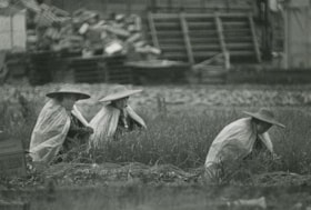
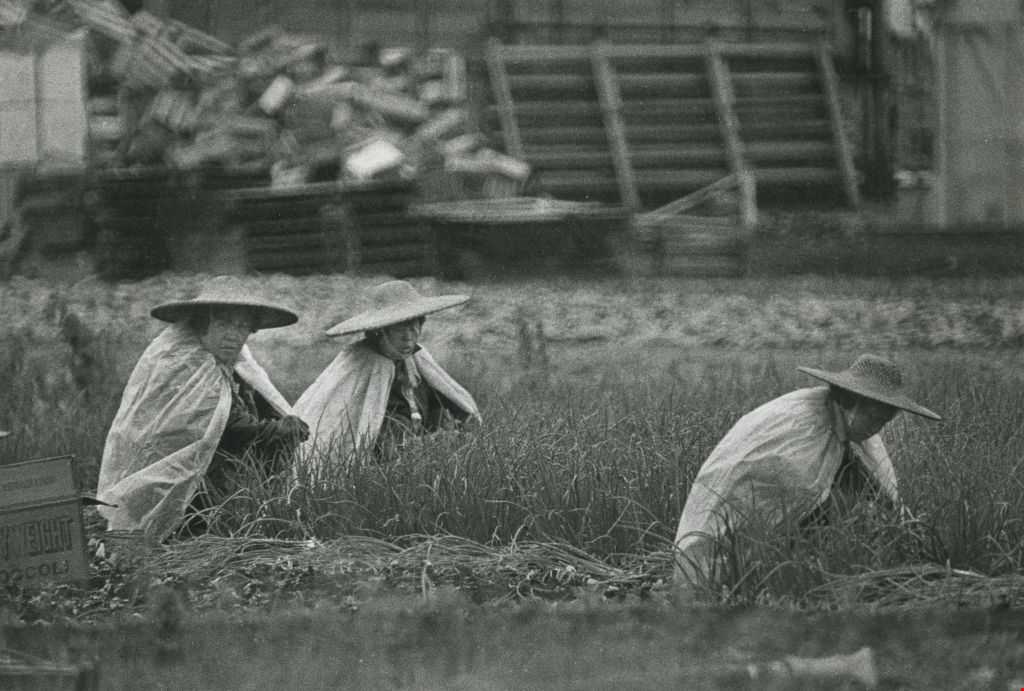
Farming in the rain
https://search.heritageburnaby.ca/link/archivedescription45325
- Repository
- City of Burnaby Archives
- Date
- July 13, 1981
- Collection/Fonds
- Columbian Newspaper collection
- Description Level
- Item
- Physical Description
- 1 photograph : b&w ; 15.5 x 22.5 cm
- Scope and Content
- Photograph of three farmers wearing straw hats and plastic shawls working in the rain in an onion field on the Burnaby flats near Meadow Street (now named Meadow Avenue).
- Repository
- City of Burnaby Archives
- Date
- July 13, 1981
- Collection/Fonds
- Columbian Newspaper collection
- Physical Description
- 1 photograph : b&w ; 15.5 x 22.5 cm
- Description Level
- Item
- Record No.
- 480-220
- Access Restriction
- No restrictions
- Reproduction Restriction
- No restrictions
- Accession Number
- 2003-02
- Scope and Content
- Photograph of three farmers wearing straw hats and plastic shawls working in the rain in an onion field on the Burnaby flats near Meadow Street (now named Meadow Avenue).
- Subjects
- Occupations - Farmers
- Media Type
- Photograph
- Photographer
- Battistoni, Peter
- Notes
- Title based on contents of photograph
- Newspaper clipping on verso of photograph reads: "WET WORK... Plastic sheets and broad straw hats protect field workers from the cool, wet elements at a farm on the Burnaby flats near Meadow Street this week. More seasonal weather, however, including rising temperatures and clearly [sic] skies, promises that life in the onion fields will be more tolerable, at least for the next little while."
- Geographic Access
- Meadow Avenue
- Historic Neighbourhood
- Fraser Arm (Historic Neighbourhood)
- Planning Study Area
- Big Bend Area
Images
![Finn Donnelly at the Swim for Salmon, [1999] thumbnail](/media/hpo/_Data/_Archives_Images/_Unrestricted/535/535-3346-1.jpg?width=280)
Finn Donnelly at the Swim for Salmon
https://search.heritageburnaby.ca/link/archivedescription98322
- Repository
- City of Burnaby Archives
- Date
- [1999]
- Collection/Fonds
- Burnaby NewsLeader photograph collection
- Description Level
- File
- Physical Description
- 2 photographs (tiff) : col.
- Scope and Content
- File contains photographs of marathon swimmer Finn Donnelly at Fraser Foreshore Park after completing the second leg of the Swim for Salmon event as part of BC Rivers Day. Photographs depict Donnelly posing on the shore and helping unidentified members of his crew to move canoes out of the Fraser R…
- Repository
- City of Burnaby Archives
- Date
- [1999]
- Collection/Fonds
- Burnaby NewsLeader photograph collection
- Physical Description
- 2 photographs (tiff) : col.
- Description Level
- File
- Record No.
- 535-3346
- Access Restriction
- No restrictions
- Reproduction Restriction
- No restrictions
- Accession Number
- 2018-12
- Scope and Content
- File contains photographs of marathon swimmer Finn Donnelly at Fraser Foreshore Park after completing the second leg of the Swim for Salmon event as part of BC Rivers Day. Photographs depict Donnelly posing on the shore and helping unidentified members of his crew to move canoes out of the Fraser River.
- Media Type
- Photograph
- Photographer
- Bartel, Mario
- Notes
- Title based on caption
- Collected by editorial for use in a September 1999 issue of the Burnaby NewsLeader
- Caption from metadata for 535-3346-1: "Marathon swimmer Finn Donnelly emerges from the Fraser River at Foreshare Park, after completing the second leg of his Swim for the Salmon to mark BC Rivers Day."
- Caption from metadata for 535-3346-2: "Marathon swimmer Finn Donnelly helps bring ashore some of the voyageur canoes which accompanied him on the second leg of his Swim for the Salmon, on the Fraser River from New West Quay to Foreshore Park."
- Geographic Access
- Fraser River
- Burnaby Fraser Foreshore Park
- Historic Neighbourhood
- Fraser Arm (Historic Neighbourhood)
- Planning Study Area
- Big Bend Area
Images
![Finn Donnelly at the Swim for Salmon, [1999] thumbnail](/media/hpo/_Data/_Archives_Images/_Unrestricted/535/535-3346-1.jpg)
![Gay Tim Hong and Steven Chan in Hop-On Farm greenhouse, [between 1980 and 1985] (date of original), copied 2017 thumbnail](/media/hpo/_Data/_BVM_Images/2017/2017_0036_0012_001.jpg?width=280)
Gay Tim Hong and Steven Chan in Hop-On Farm greenhouse
https://search.heritageburnaby.ca/link/museumdescription4261
- Repository
- Burnaby Village Museum
- Date
- [between 1980 and 1985] (date of original), copied 2017
- Collection/Fonds
- Burnaby Village Museum Photograph collection
- Description Level
- Item
- Physical Description
- 1 photograph : colour : copy scan
- Scope and Content
- Photograph of Gay Tim Hong standing with great grandson, Steven Chan in middle of a Hop-On Farm greenhouse. Greenhouse contained marigolds.
- Repository
- Burnaby Village Museum
- Collection/Fonds
- Burnaby Village Museum Photograph collection
- Description Level
- Item
- Physical Description
- 1 photograph : colour : copy scan
- Scope and Content
- Photograph of Gay Tim Hong standing with great grandson, Steven Chan in middle of a Hop-On Farm greenhouse. Greenhouse contained marigolds.
- History
- Josephine Hong was born to Sui Ha Hong and Chan Kow Hong. The Hong Family had seven children, oldest to youngest: Pauline, Josephine, Catherine, Norine, Gary, Darlene, and Marlene. The family runs Hop-On Farm on Marine Drive in Burnaby. Many Hong family members worked on the farm including Josephine Hong's grandfather, Gay Tim Hong, and uncles. Her great-grandfather was Sui Wing Hong
- Subjects
- Persons - Chinese Canadians
- Geographic Access
- Byrne Road
- Accession Code
- BV017.36.12
- Access Restriction
- No restrictions
- Reproduction Restriction
- May be restricted by third party rights
- Date
- [between 1980 and 1985] (date of original), copied 2017
- Media Type
- Photograph
- Historic Neighbourhood
- Fraser Arm (Historic Neighbourhood)
- Related Material
- See Oral History Interview-BV020.6.1
- Scan Resolution
- 800
- Scan Date
- 12/3/2017
- Scale
- 100
- Notes
- Title based on contents of photograph.
Images
![Gay Tim Hong and Steven Chan in Hop-On Farm greenhouse, [between 1980 and 1985] (date of original), copied 2017 thumbnail](/media/hpo/_Data/_BVM_Images/2017/2017_0036_0012_001.jpg)