Narrow Results By
Subject
- Advertising Medium - Signs and Signboards 1
- Animals - Fish 1
- Arts 2
- Arts - Drawings 2
- Arts - Paintings 2
- Arts - Sculptures 2
- Buildings - Civic - Art Galleries 3
- Buildings - Civic - City Halls 1
- Buildings - Civic - Hospitals 3
- Buildings - Civic - Museums 1
- Buildings - Commercial - Offices 1
- Buildings - Recreational - Sports 1
Person / Organization
- Alpha Secondary School 1
- Anderson, Cliff 2
- Armstrong Avenue School 1
- Arthritis Society 1
- Blamey, Sue Fuller 1
- Brentwood Park School 1
- British Columbia Government Employees' Union 2
- British Columbia Institute of Technology 8
- British Columbia Ministry of Education 1
- British Columbia School Trustees Association 1
- Brown, Clifton Gilbert, 1889-1960 1
- Burnaby Art Gallery 3

Kingsway East School
https://search.heritageburnaby.ca/link/landmark546
- Repository
- Burnaby Heritage Planning
- Description
- The Kingsway East School is a two-storey wood-frame Arts and Crafts styled building. The school, and the adjacent cenotaph and memorial tennis courts, comprise Burnaby South Memorial Park.
- Associated Dates
- 1913
- Formal Recognition
- Heritage Designation, Community Heritage Register
- Other Names
- Alan Emmott Centre
- Street View URL
- Google Maps Street View
- Repository
- Burnaby Heritage Planning
- Other Names
- Alan Emmott Centre
- Geographic Access
- Southoaks Crescent
- Associated Dates
- 1913
- Formal Recognition
- Heritage Designation, Community Heritage Register
- Enactment Type
- Bylaw No. 9807
- Enactment Date
- 23/11/1992
- Description
- The Kingsway East School is a two-storey wood-frame Arts and Crafts styled building. The school, and the adjacent cenotaph and memorial tennis courts, comprise Burnaby South Memorial Park.
- Heritage Value
- This school structure completed in 1913, the oldest surviving public education building in the city, was intended to be the auditorium and gymnasium for Burnaby’s first high school. However, because of the 1913 recession and the outbreak of the First World War, it was utilized as the Kingsway East Elementary School for the Edmonds District until 1921. Burnaby South High School opened here in 1922, and after it relocated this building was used for a variety of school purposes until it became redundant. The school was rehabilitated for community purposes in 2002-03 and renamed the Alan Emmott Centre to honor a former Mayor of Burnaby. The impressive scale of the Kingsway East School is indicative of the relative size of the community and its growing demand for schooling at the time of construction, illustrating the value that early community residents placed on education. Built to plans of the Burnaby School Board architect, Joseph Henry Bowman (1864-1943), it also indicates the individual values and design control exercised by the school board during this era. It is also significant for its Arts and Crafts style, allied to the typical Craftsman residential vocabulary, which was employed locally for school buildings of the Edwardian era. By using a common architectural vocabulary, this allowed the institution to reflect the values and aspirations of the local community. The Arts and Crafts style also demonstrated an allegiance to British educational antecedents and a demonstration of loyalty to the Mother Country.
- Historic Neighbourhood
- Edmonds (Historic Neighbourhood)
- Planning Study Area
- Kingsway-Beresford Area
- Function
- Primary Historic--Primary School
- Community
- Burnaby
- Cadastral Identifier
- P.I.D. No. 016-367-154 Legal Description: Lot 1, District Lot 96, Group 1 New Westminster District, Plan 86581
- Boundaries
- The Kingsway East School is comprised of a single municipally-owned property located at 6650 Southoaks Crescent, Burnaby.
- Area
- 6,070.00
- Contributing Resource
- Building
- Landscape Feature
- Structure
- Ownership
- Public (local)
- Documentation
- Heritage Site Files: PC77000 20. City of Burnaby Planning and Building Department, 4949 Canada Way, Burnaby, B.C., V5G 1M2
- Street Address
- 6650 Southoaks Crescent
- Street View URL
- Google Maps Street View
Images


British Columbia Institute of Technology (BCIT)
https://search.heritageburnaby.ca/link/landmark806
- Repository
- Burnaby Heritage Planning
- Geographic Access
- Willingdon Avenue
- Associated Dates
- 1960
- Heritage Value
- The BC Vocational School was established in 1960 at Willingdon and Canada Way. By 1964, the British Columbia Insitute of Technology had opened and had 498 students enrolled. In the 1970s, the BC Vocational School had been renamed the Pacific Vocational Institute and in 1986 the two institutions merged. The school is a public post-secondary institution that is governed by a Board of Governors, under the authority of the Ministry of Advanced Education, Training and Technology. By 2004, the annual enrolment of part-time and full-time students reached 48,000.
- Planning Study Area
- Douglas-Gilpin Area
- Street Address
- 3700 Willingdon Avenue
- Street View URL
- Google Maps Street View
Images


Burnaby North High School
https://search.heritageburnaby.ca/link/landmark745
- Repository
- Burnaby Heritage Planning
- Associated Dates
- 1923-1982
- Street View URL
- Google Maps Street View
- Repository
- Burnaby Heritage Planning
- Geographic Access
- Willingdon Avenue
- Associated Dates
- 1923-1982
- Heritage Value
- Burnaby North and Burnaby South were the first high schools built in the City. Before the high school opened, Burnaby students had to travel to Vancouver if they wished to pursue education beyond an elementary level. In 1921, arrangements were made to use the basement of the Presbyterian Church for instruction of local students. By 1922 the Burnaby North High School opened at its first permanent location (4375 Pandora Street - which is now Rosser Elementary). In 1945, the Willingdon Avenue site was built and was used until a new building was constructed in 1961 on Hammarskjold Drive. From 1962, the school was used as Burnaby Heights Junior High school, but it closed in 1982 and the junior high students went to the new Burnaby North on Hammarskjold.
- Historic Neighbourhood
- Capitol Hill (Historic Neighbourhood)
- Planning Study Area
- Capitol Hill Area
- Street Address
- 250 Willingdon Avenue
- Street View URL
- Google Maps Street View
Images


Burnaby South High School
https://search.heritageburnaby.ca/link/landmark770
- Repository
- Burnaby Heritage Planning
- Associated Dates
- 1922-1988
- Street View URL
- Google Maps Street View
- Repository
- Burnaby Heritage Planning
- Geographic Access
- Southoaks Crescent
- Associated Dates
- 1922-1988
- Heritage Value
- Burnaby South and Burnaby North were Burnaby's first high schools. The first rooms of the school were built in 1922 on the same grounds as the Kingsway East Elementary School. In 1940, a two-storey building was erected and additions were made in 1963, 1967 and 1972. Kingsway East closed in 1925 and its buildings were used by the high school for Industrial Arts and Home Economics. In the early 1990s, a new "urban education centre" (Burnaby South/B.C. School for the Deaf) was opened, replacing the old Burnaby South High School.
- Historic Neighbourhood
- Edmonds (Historic Neighbourhood)
- Planning Study Area
- Kingsway-Beresford Area
- Street Address
- 6650 Southoaks Crescent
- Street View URL
- Google Maps Street View
Images


Douglas-Gilpin Neighbourhood
https://search.heritageburnaby.ca/link/landmark799
- Repository
- Burnaby Heritage Planning
- Associated Dates
- 1955-2008
- Heritage Value
- The Douglas-Gilpin Neighbourhood developed into a diverse area incorporating residential, business, educational and park districts in the period after 1955. The BCIT site was built in the early 1960s, shortly after the Burnaby Municipal Hall was located on Canada Way near Deer Lake in 1956. The construction of the Municipal Hall at this location fostered the creation of an administrative and business centre adjacent to the park, while the northern and central areas of the neighbourhood retained their primarily residential character.
- Historic Neighbourhood
- Burnaby Lake (Historic Neighbourhood)
- Planning Study Area
- Douglas-Gilpin Area
Images


Kitchener Elementary School
https://search.heritageburnaby.ca/link/landmark614
- Repository
- Burnaby Heritage Planning
- Description
- School building.
- Associated Dates
- 1925
- Street View URL
- Google Maps Street View
- Repository
- Burnaby Heritage Planning
- Geographic Access
- Gilmore Avenue
- Associated Dates
- 1925
- Description
- School building.
- Heritage Value
- This landmark school was designed by the architectural firm of Bowman & Cullerne, specialists in the design of educational facilities. After Harold Cullerne (1890-1976) returned from service during the First World War, he joined J.H. Bowman (1864-1943) in a partnership that lasted from 1919 to 1934. The firm’s projects include the Seaforth School (1922, now relocated to Burnaby Village Museum), Burnaby North High School (1923), and the Nelson Avenue School (1927). This was originally designed as a two-storey, four-room building in 1925, with two-storey four-room wings added two years later. The building has been altered with the addition of stucco cladding over the original siding and replacement windows, but has retained its original form and massing, as well as its domed roof ventilator.
- Locality
- Vancouver Heights
- Historic Neighbourhood
- Vancouver Heights (Historic Neighbourhood)
- Planning Study Area
- Willingdon Heights Area
- Architect
- Bowman & Cullerne
- Area
- 20478.11
- Contributing Resource
- Building
- Street Address
- 1351 Gilmore Avenue
- Street View URL
- Google Maps Street View
Images


Ocean View Burial Park - Chapel
https://search.heritageburnaby.ca/link/landmark628
- Repository
- Burnaby Heritage Planning
- Geographic Access
- Imperial Street
- Associated Dates
- 1936
- Description
- Church building.
- Heritage Value
- Subsequent work at Ocean View was designed by local architects Sharp & Thompson through the 1950s, including the stone-faced Garden Chapel, built in 1936 as a replica of a Norman church. Prominent stone gates also replaced the original gates at the corner entrance. George Sharp (1880-1974) and Charles Thompson (1878-1961) formed Vancouver’s longest surviving architectural firm in 1908. They were born, educated and articled in London, before arriving in Vancouver via different routes. In 1912, the firm won the competition for the new University of British Columbia.
- Locality
- Alta Vista
- Historic Neighbourhood
- Alta Vista (Historic Neighbourhood)
- Planning Study Area
- Suncrest Area
- Architect
- Sharp & Thompson
- Area
- 359280.00
- Contributing Resource
- Building
- Ownership
- Private
- Street Address
- 4000 Imperial Street
Images


Seaforth Schoolhouse
https://search.heritageburnaby.ca/link/landmark541
- Repository
- Burnaby Heritage Planning
- Description
- The Seaforth Schoolhouse is a one-storey wood-frame rectangular plan building with a projecting entry porch, located in the Burnaby Village Museum.
- Associated Dates
- 1922
- Formal Recognition
- Heritage Designation, Community Heritage Register
- Repository
- Burnaby Heritage Planning
- Geographic Access
- Deer Lake Avenue
- Associated Dates
- 1922
- Formal Recognition
- Heritage Designation, Community Heritage Register
- Enactment Type
- Bylaw No. 8148
- Enactment Date
- 03/01/1984
- Description
- The Seaforth Schoolhouse is a one-storey wood-frame rectangular plan building with a projecting entry porch, located in the Burnaby Village Museum.
- Heritage Value
- The heritage value of the Seaforth Schoolhouse lies in its representation of a one-room school once located in one of the city’s rural districts. The school was constructed due to the demand of increasing population after the First World War, in what was then known as the Lozells District, so isolated at the time that parents were concerned about the danger to their children from wild bears and cougars that roamed the area. The school was named after its sponsor, the Seaforth Chapter of the Imperial Order of Daughters of the Empire. Bowman and Cullerne, the architects for the Burnaby School Board, designed the one room schoolhouse. It was constructed by local contractor, Alphonse J. Toebaert, following the standards of British Columbia public school architecture, which specified the plan and orientation of the building. It indicates the values and the design control of school boards of the time, and the central role of the provincial government in setting educational standards. The heritage value of this school also lies in its interpretive value within the Burnaby Village Museum. The site is an important cultural feature for the interpretation of Burnaby’s heritage to the public, illustrating the changes in the local school system over time. The school was moved to Burnaby Village Museum in 1983, and was opened to the public after extensive restoration in 1987. Both the interior and exterior have been restored and interpreted to the date of original construction. The North Vancouver School Board donated most of the early desks, and the remainder of the interior artifacts are from the museum’s own collection.
- Defining Elements
- Key elements that define the heritage character of the Seaforth Schoolhouse include its: - rectangular plan - hipped roof with cedar shingle cladding - hipped-roof entry porch - typical school fenestration of the era, with a bank of double-hung 6-over-6 wooden-sash windows on one facade - cedar shingle cladding - original and authentic interior elements such as interior mouldings, blackboards and desks
- Locality
- Deer Lake Park
- Historic Neighbourhood
- Burnaby Lake (Historic Neighbourhood)
- Planning Study Area
- Morley-Buckingham Area
- Organization
- Seaforth Chapter of the Imperial Order of Daughters of the Empire
- Burnaby School Board
- Burnaby Village Museum
- Architect
- Bowman and Cullerne
- Builder
- Alphonse J. Toebaert
- Function
- Primary Historic--One-Room School
- Primary Current--Museum
- Community
- Burnaby
- Cadastral Identifier
- P.I.D. No. 011-030-356 Legal Description: Parcel 1, District Lot 79 and District Lot 85, Group 1, New Westminster District, Reference Plan 77594
- Boundaries
- Burnaby Village Museum is comprised of a single municipally-owned property located at 6501 Deer Lake Avenue, Burnaby.
- Area
- 38,488.63
- Contributing Resource
- Building
- Landscape Feature
- Structure
- Ownership
- Public (local)
- Documentation
- Heritage Site Files: PC77000 20. City of Burnaby Planning and Building Department, 4949 Canada Way, Burnaby, B.C., V5G 1M2
- Street Address
- 6501 Deer Lake Avenue
Images


Simon Fraser University
https://search.heritageburnaby.ca/link/landmark639
- Repository
- Burnaby Heritage Planning
- Description
- The planning, design concept, design coordination, site development and landscaping for the original part of the campus were all under the control of Erickson/Massey. The complex was conceived as one building, with future growth occurring at the periphery. Tall buildings would have been out of scal…
- Associated Dates
- 1965
- Street View URL
- Google Maps Street View
- Repository
- Burnaby Heritage Planning
- Geographic Access
- University Drive
- Associated Dates
- 1965
- Description
- The planning, design concept, design coordination, site development and landscaping for the original part of the campus were all under the control of Erickson/Massey. The complex was conceived as one building, with future growth occurring at the periphery. Tall buildings would have been out of scale with the massive mountaintop ridge, so a series of horizontal terraced structures were designed that hugged the ridge and dissolve into the landscape. Following the linear peak of the mountain, the scheme organized various parts of the campus along an east/west line. The concept of a central academic quadrangle was conceived within the tradition of Oxford and Cambridge, and to enhance the sense of contemplative quiet, it was designed as a perfect square raised on massive pilotis, allowing stunning views through a landscaped courtyard. The connecting link was a gigantic space frame-developed in conjunction with Jeffrey Lindsay, a one-time associate of Buckminster Fuller-that provided shelter and a gathering-place for the students. Other architects who had placed among the top five in the competition were retained to design the individual components of the original plan: the Academic Quadrangle by Zoltan S. Kiss; the Theatre, Gymnasium & Swimming Pool by Duncan McNab & Associates; the Science Complex by Rhone & Iredale; and the Library by Robert F. Harrison.
- Heritage Value
- Following the end of the Second World War, there was unprecedented growth throughout the Lower Mainland. Many returning veterans had settled on the coast, and the loosening of wartime restrictions led to the creation of many new suburban developments throughout the region. The growing population strained existing facilities, and there was a recognition that new educational facilities had to be constructed to meet these growing demands. For many years, the only university in the province was the University of British Columbia. In the 1960s, new universities were planned for both Victoria and Burnaby to serve the wave of baby boomers just then going through high school. The dramatic site chosen for the Burnaby university was the top of Burnaby Mountain, with expansive views over mountain ranges and water. An architectural competition was held for a campus of 7,000 students that could eventually be expanded to 18,000. Of the many submissions, the judges reached unanimity on the winner, an outstanding scheme submitted by the firm of Erickson/Massey. The judges went even further, and recommended that every effort be made to ensure that the winning design be built as submitted. The new Chancellor, Gordon Shrum, agreed. The realization of this scheme won extensive recognition for the work of Arthur Erickson and Geoffrey Massey, and launched Erickson’s international career. In Erickson’s words: "Unlike any previous university, Simon Fraser is a direct translation into architecture of the expanding fields of knowledge that defy traditional boundaries, of the vital role of the university as both challenger and conservor of human culture, and of the university community as one in constant intellectual, spiritual and social interchange." The new school opened for classes in September 1965, nicknamed the “instant university,” and quickly gained a radical reputation. The startling futuristic architecture and open layout suited the explosive nature of the mid-1960s, when political and social traditions of all types were being questioned and student protests were common. Many of SFU’s programs were considered experimental, even controversial, and unrest and conflict on the campus continued for a number of years. Since this auspicious beginning 40 years ago, SFU has grown to house 25,000 students on three campuses. The core of the original campus, recognized world-wide as a profound work of architecture, remains essentially intact today.
- Locality
- Burnaby Mountain
- Historic Neighbourhood
- Barnet (Historic Neighbourhood)
- Planning Study Area
- Burnaby Mountain Area
- Architect
- Erickson/Massey
- Area
- 1360000.00
- Contributing Resource
- Building
- Ownership
- Private
- Street Address
- 8888 University Drive
- Street View URL
- Google Maps Street View
Images


South Burnaby Parent Participation Preschool fonds
https://search.heritageburnaby.ca/link/archivedescription84942
- Repository
- City of Burnaby Archives
- Date
- 1957-2001
- Collection/Fonds
- South Burnaby Parent Participation Preschool fonds
- Description Level
- Fonds
- Physical Description
- 52 cm. of textual records + 129 photographs (113 photographs : col. negatives, 35 mm ; 12 photographs : col. negatives, 15 mm ; 5 photograph : col., 15 x 10 cm) + 3 moving images (2 film reel (100 ft.) : kodak kodachrome, col., [sd.], 8mm ; 1 film reel (50 ft.) : kodak kodachrome, col., no sound ; 8mm).
- Scope and Content
- Fonds consists of all records generated by the South Burnaby Parent Participation Preschool between 1957-2001 during their operational functions under the Societies Act.
- Repository
- City of Burnaby Archives
- Date
- 1957-2001
- Collection/Fonds
- South Burnaby Parent Participation Preschool fonds
- Physical Description
- 52 cm. of textual records + 129 photographs (113 photographs : col. negatives, 35 mm ; 12 photographs : col. negatives, 15 mm ; 5 photograph : col., 15 x 10 cm) + 3 moving images (2 film reel (100 ft.) : kodak kodachrome, col., [sd.], 8mm ; 1 film reel (50 ft.) : kodak kodachrome, col., no sound ; 8mm).
- Description Level
- Fonds
- Access Restriction
- In Archives only
- Reproduction Restriction
- May be restricted by third party rights
- Accession Number
- 2014-06
- Scope and Content
- Fonds consists of all records generated by the South Burnaby Parent Participation Preschool between 1957-2001 during their operational functions under the Societies Act.
- History
- The South Burnaby United Church Cooperative Play group was formed as a society under the Societies Act in September 1954 when a group of parents in Burnaby decided to create a parent participation and cooperative preschool for children age three to five. The preschool was located at the South Burnaby United Church, 7551 Gray Avenue in Burnaby. The society hired early childhood educators, offering preschool classes in the mornings. In 1961, the preschool expanded in offering classes in both mornings and afternoons. In 1959, they changed their name to South Burnaby Cooperative Preschool Group. In the 1970s, they were also known as the South Burnaby Nursery School and The South Burnaby Cooperative Nursery School Group. They later rebranded in the 1980s as the South Burnaby Parent Participation Preschool and were also known as the South Burnaby Preschool. The preschool was based on the following principles in their constitution: a) To promote principles of preschool education in which children through play develop socially, physically, emotionally and intellectually; b) To provide a high standard of preschool education in which children through play develop socially, physically, emotionally and intellectually; c) To encourage and facilitate opportunities for parents to observe and learn about the development, needs and behavior of children; and d) To do everything incidental and necessary to promote and attain the foregoing objects. Presidents of the Society included: Helen Gray (1957-1958); Dorothy Lyeler (1958-1959); G.L. Bancroft; Helen Stone (1959-1960); Carol Jane Gray (1969-1970); Nancy Gordon (1970-1971); Barbara Spitz (1971-1972); Debby Fry (1976-1977); Jill Johneox (1977-1978); Nancy Lewis (1980-1981); Nancy Lewis (1983-1984); Lynda Walsh (1984-1985); Margaret Stevens (1985-1986); Nina Crowe (1987-1988); Carol McRae and Cathy Lauzon (1988-1989); Tracy Sawatzky (1996-1997); Shelley Molarni and Charmaine Calbick (1997-1998); Kathie Owen (1999-2000); and Susie Jackson (2001-2002). The first supervisor was Rhoda Darnbrough (1954-1981). All parents who had children enrolled in the preschool were responsible for the administration and staffing of the preschool under the guidance of a qualified preschool teacher. Parents occupied positions on the executive, assisting in the general administration and helping out in the classroom under the guidance of the supervising teacher. The society was an active member of the Council of Parent Participation Preschools in B.C., which was established in 1960 as The Association of Cooperative Pre School Groups, and adhered to the Council's statements of standards and common practices. Members from the preschool executive sat on the South Burnaby executive of the CPPPBC. Salaries were paid to educators in accordance with the Parent Participation Preschool Teachers' Association. In 1958, the preschool was chosen by the Play Groups Association of BC as an Observation Centre and was selected for many years following. The preschool participated in fundraising activities and was granted Gaming/Casino funding to help purchase supplies and furnishings for their facility. The preschool closed in 2001.
- Media Type
- Photograph
- Textual Record
- Moving Images
- Notes
- Title based on contents of fonds
- MSS181, photo/MI catalogue 563
Anik-B educational television system
https://search.heritageburnaby.ca/link/archivedescription45456
- Repository
- City of Burnaby Archives
- Date
- 1979
- Collection/Fonds
- Columbian Newspaper collection
- Description Level
- Item
- Physical Description
- 1 photograph : b&w ; 19 x 22.5 cm
- Scope and Content
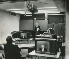
- Photograph of Education Minister Pat McGreer delivering the first message with the Anik-B educational television system which connected fourteen classrooms around the province and in the Northwest Territories to the originating studio at the British Columbia Institute of Technology.
- Repository
- City of Burnaby Archives
- Date
- 1979
- Collection/Fonds
- Columbian Newspaper collection
- Physical Description
- 1 photograph : b&w ; 19 x 22.5 cm
- Description Level
- Item
- Record No.
- 480-351
- Access Restriction
- No restrictions
- Reproduction Restriction
- No restrictions
- Accession Number
- 2003-02
- Scope and Content
- Photograph of Education Minister Pat McGreer delivering the first message with the Anik-B educational television system which connected fourteen classrooms around the province and in the Northwest Territories to the originating studio at the British Columbia Institute of Technology.
- Media Type
- Photograph
- Photographer
- Battistoni, Peter
- Notes
- Title based on contents of photograph
- Newspaper clipping attached to verso of photograph reads: "ON THE AIR ... The Anik-B educational television system went on the air live Monday as Education Minister Pat McGreer delivered the first message. The system connects some 14 classrooms around the province and in the Northwest Territories to the originating studio at BCIT. The lessons are beamed via sattelite [sic] to the classrooms, most of which have the capacity to talk back to the instructor during the lesson."
- Note on recto of photograph reads: "CAMERA IS AT TOP ON PHOTO."
- Geographic Access
- Willingdon Avenue
- Street Address
- 3700 Willingdon Avenue
- Historic Neighbourhood
- Burnaby Lake (Historic Neighbourhood)
- Planning Study Area
- Douglas-Gilpin Area
Images
Dr. Sadhu Binning fonds
https://search.heritageburnaby.ca/link/museumdescription19279
- Repository
- Burnaby Village Museum
- Date
- [1984]
- Collection/Fonds
- Dr. Sadhu Binning fonds
- Description Level
- Fonds
- Physical Description
- 2 photographs : col.
- Scope and Content
- Fonds consists of two photographs of actors from Vancouver Sath performing in the play "Maluka" at Sexsmith Elementary School.
- Repository
- Burnaby Village Museum
- Collection/Fonds
- Dr. Sadhu Binning fonds
- Description Level
- Fonds
- Physical Description
- 2 photographs : col.
- Scope and Content
- Fonds consists of two photographs of actors from Vancouver Sath performing in the play "Maluka" at Sexsmith Elementary School.
- History
- Dr. Sadhu Binning was born on May 10, 1947 to mother Gurmej Kaur and father Jeet Singh Binning. Due to lack of proper records management in India at the time of his birth, it is believed that he was actually born sometime in December of 1947. He grew up alongside two brothers and one sister in a village located in Kapurthala, Punjab. Dr. Binning attended secondary school in the nearby city of Phagwara, Punjab although he did not complete his education here. Throughout his childhood, he enjoyed reading both Punjabi and Hindi novels and learned how to read Urdu as well. Dr. Binning’s uncle, Dhana Singh immigrated to Canada in 1933 and returned to India in 1953. When Dhana Singh returned to Canada in 1957, he sponsored Dr. Binning’s father, Jeet Singh Binning to immigrate. Dhana Singh co-owned a few saw mills in British Columbia and also worked in the truck driving industry. Dr. Binning remembers that some people who had lived in Canada would visit their village and that they appeared to be strong and healthy and looked happy. He also noticed that they would eat meat, so whenever they would visit there would be meat available. In 1967, when he was nineteen and a half years old, Dr. Binning immigrated Canada to join his father. He recalls his father and uncle and a friend arriving at the airport to pick him up. During his first few days, Dr. Binning made the decision to remove his turban and beard upon receiving advice from his uncle. Dr. Binning first obtained work on a farm in Abbotsford, working alongside his mother. While working, Dr. Binning also attended English classes in Vancouver. Dr. Binning’s Uncle Dhana Singh worked in a Vancouver saw mill and tried to help find work for his nephew but was unsuccessful. Dr. Binning soon found work at a saw mill in Avola and worked there until the end of the summer until a friend helped find him work in a saw mill in North Vancouver. During his free time, he enjoyed camping with friends. In 1970, Dr. Binning left the saw mill after obtaining a job at the post office. The post office offered lower wages than working at the mill but Dr. Binning believed that he would become more educated working here. While working as a postman, Dr. Binning recalls facing a lot of discrimination and racism and was often referred to as a ‘Paki’ multiple times a day. In 1973, Dr. Binning married Jagish Sihota. Sadhu and Jagdish originated from nearby villages in India and met each other in Canada. Dr. Binning’s wife, Jagdish worked at the Royal Bank of Canada for thirty years until her retirement. While working, she also looked after the household and their son and daughter. Jagdish also handwrote a magazine, “Watno Dur’ (English translation: ‘away from homeland’) which was distributed in the community. In 1976, Dr. Binning became the editor of the magazine and the name was later changed to “Watan’ as they had accepted their new homeland of Canada. While working at the post office, Dr. Binning also attended night school starting in eighth grade. After receiving his high school diploma, he was accepted to Simon Fraser University and earned a Bachelor of Arts degree with a double major in Anthropology and Sociology and in 1986 he obtained a Masters degree from Simon Fraser University. While attending university, Dr. Binning was very active within the community and wanted to work to improve society. He first thought that he would return to India to contribute and improve rights in his homeland but upon seeing the prevalence of the movements in Canada, he realized that work needed to be done here too. In 1983, Dr. Binning became a founding member and contributor to a theatrical collective known as “Vancouver Sath”. The theatrical group produced plays that represented societal issues and were invited to perform at multiple conferences throughout British Columbia and Canada. The group focused and acknowledged the many issues in Punjab and in Canada. One of the plays that the group produced focused on the exploitation of Punjabi women who worked on farms in Canada. Dr. Binning continued to be involved as an integral member of Vancouver Sath until 1995. Over the years, Dr. Binning has strongly lobbied for Punjabi language education and between 1988 and 2008 he worked as Punjabi instructor at the University of British Columbia. He first worked as a teaching assistant at UBC under Dr. Harjot Oberoi and due to low wages, he simultaneously worked at the Post Office. In 2019, Dr. Binning received an Honorary Doctor of Letters from UBC in recognition of his work. Since 1973, Dr. Binning has lived in Burnaby and has resided in the same home that he and his wife purchased in 1987. In his free time, he enjoys cycling, watercolour painting, travelling abroad and going on road trips.
- Creator
- Binning, Dr. Sadhu
- Accession Code
- BV023.7
- Date
- [1984]
- Media Type
- Photograph
- Related Material
- See also artifacts descriptions for related materials re: Vancouver Sath and Watan magazine: BV023.7.1 to BV023.7.16
- Notes
- Title based on contents of fonds
Rhoda Jeffers fonds
https://search.heritageburnaby.ca/link/museumdescription4146
- Repository
- Burnaby Village Museum
- Date
- [1910-1960]
- Collection/Fonds
- Rhoda Jeffers fonds
- Description Level
- Fonds
- Physical Description
- .5 cm of textual records + 31 photographs
- Scope and Content
- The fonds consists of a collection of family photographs and a small collection of personal records, correspondence and education records belonging to Rhoda Jeffers during her work as a teacher. Fonds is arranged into series: 1) Jeffers family photographs series 2) Education and personal records s…
- Repository
- Burnaby Village Museum
- Collection/Fonds
- Rhoda Jeffers fonds
- Description Level
- Fonds
- Physical Description
- .5 cm of textual records + 31 photographs
- Scope and Content
- The fonds consists of a collection of family photographs and a small collection of personal records, correspondence and education records belonging to Rhoda Jeffers during her work as a teacher. Fonds is arranged into series: 1) Jeffers family photographs series 2) Education and personal records series
- History
- Rhoda Maie Jeffers (middle name also spelled Mae) was born in July 1, 1904 in River Hebert, Nova Scotia to Albert Clifford Jeffers (1877 - 1967) and Eldora McAloney (1879 - 1978). The family moved to British Columbia in 1912, living in Vancouver at various addresses before moving to Burnaby around 1950 residing at 4254 Charles Street. Albert and Eldora Jeffers had three children; Rhoda Maie (Mae), Sarah Etta "Muriel" (later Webster) and Charles Kenneth Leroy (1906-1970). Rhoda began teaching in Grand Forks in 1922 and one of her early teaching posts included Eriksdale, Manitoba. Rhoda divided her teaching career between Alberta, Lake Cowichan, Agassiz and North Delta. In 1952, Rhoda worked as an exchange teacher in England and in 1957, Rhoda graduated from UBC with a Bachelor of Education (secondary specialization). Due to a severe injury in 1969, Rhoda was forced to retire and sometime after, she moved in with her parents at 4254 Charles Street. Rhoda continued to reside at this address until a year before her death in 1990.
- Creator
- Jeffers, Rhoda Mae
- Accession Code
- BV007.20
- Date
- [1910-1960]
- Media Type
- Textual Record
- Photograph
- Notes
- Title based on contents of fonds
- See also portrait of Rhoda Jeffers [c. 1915] BV077.20.2
"Step back in Time" slide programme kit
https://search.heritageburnaby.ca/link/museumdescription13703
- Repository
- Burnaby Village Museum
- Date
- 1978-1979
- Collection/Fonds
- Century Park Museum Association fonds
- Description Level
- File
- Physical Description
- 39 photograph : col. slides ; 35 mm
- Scope and Content
- File consists photographs from Heritage Village Museum Education Department "Step Back in Time" slide programme kit. Photographs document various Heritage Village Museum exhibits and programming.
- Repository
- Burnaby Village Museum
- Collection/Fonds
- Century Park Museum Association fonds
- Description Level
- File
- Physical Description
- 39 photograph : col. slides ; 35 mm
- Scope and Content
- File consists photographs from Heritage Village Museum Education Department "Step Back in Time" slide programme kit. Photographs document various Heritage Village Museum exhibits and programming.
- Subjects
- Education
- Names
- Burnaby Village Museum
- Accession Code
- BV020.5.894
- Access Restriction
- No restrictions
- Reproduction Restriction
- No known restrictions
- Date
- 1978-1979
- Media Type
- Photograph
- Scan Resolution
- 2400
- Scan Date
- September 1, 2020
- Scale
- 100
- Notes
- Title based on contents of photographs
- Labels on original container read: "STEP BACK IN TIME / Slide Programme / 1978-79 kit / School Programs - new photos / Education Department / Heritage Village Museum / COPY 1" (container was disposed of and slides were rehoused)
- Slides are numbered BV020.5.894.1 to BV020.5.894.14 in the order that they were found at the time of the description.
Images

![Tom Christenson and Harry Bloy at Stoney Creek Community School, [2005] thumbnail](/media/hpo/_Data/_Archives_Images/_Unrestricted/535/535-1854-1.jpg?width=280)
Tom Christenson and Harry Bloy at Stoney Creek Community School
https://search.heritageburnaby.ca/link/archivedescription96157
- Repository
- City of Burnaby Archives
- Date
- [2005]
- Collection/Fonds
- Burnaby NewsLeader photograph collection
- Description Level
- File
- Physical Description
- 2 photographs (tiff) : col.
- Scope and Content
- File contains photographs of BC Education Minister Tom Christenson and MLA Harry Bloy with young students at Stoney Creek Community School during a tour of Burnaby schools.
- Repository
- City of Burnaby Archives
- Date
- [2005]
- Collection/Fonds
- Burnaby NewsLeader photograph collection
- Physical Description
- 2 photographs (tiff) : col.
- Description Level
- File
- Record No.
- 535-1854
- Access Restriction
- No restrictions
- Reproduction Restriction
- No restrictions
- Accession Number
- 2018-12
- Scope and Content
- File contains photographs of BC Education Minister Tom Christenson and MLA Harry Bloy with young students at Stoney Creek Community School during a tour of Burnaby schools.
- Media Type
- Photograph
- Photographer
- Bartel, Mario
- Notes
- Title based on caption
- Collected by editorial for use in a January 2005 issue of the Burnaby NewsLeader
- Caption from metadata for 535-1854-1: "BC Education Minister Tom Christenson drops in on the roots of empathy program at Stoney Creek Community School during a tour of Burnaby schools on Wednesday."
- Caption from metadata for 535-1854-2: "MLA Harry Bloy hands out reading packages to kindergarten students at Stoney Creek Community School, during a tour of Burnaby schools with education minister Tom Christenson on Wednesday."
- Geographic Access
- Eastlake Drive
- Street Address
- 8800 Eastlake Drive
- Historic Neighbourhood
- Burquitlam (Historic Neighbourhood)
- Planning Study Area
- Lyndhurst Area
Images
![Tom Christenson and Harry Bloy at Stoney Creek Community School, [2005] thumbnail](/media/hpo/_Data/_Archives_Images/_Unrestricted/535/535-1854-1.jpg)
![Barbara Guttmann-Gee, [2000] thumbnail](/media/hpo/_Data/_Archives_Images/_Unrestricted/535/535-3111.jpg?width=280)
Barbara Guttmann-Gee
https://search.heritageburnaby.ca/link/archivedescription98007
- Repository
- City of Burnaby Archives
- Date
- [2000]
- Collection/Fonds
- Burnaby NewsLeader photograph collection
- Description Level
- Item
- Physical Description
- 1 photograph (tiff) : col.
- Scope and Content
- Photograph of Barbara Guttmann-Gee, a Simon Fraser University alumna, posing with a stack of books.
- Repository
- City of Burnaby Archives
- Date
- [2000]
- Collection/Fonds
- Burnaby NewsLeader photograph collection
- Physical Description
- 1 photograph (tiff) : col.
- Description Level
- Item
- Record No.
- 535-3111
- Access Restriction
- No restrictions
- Reproduction Restriction
- No restrictions
- Accession Number
- 2018-12
- Scope and Content
- Photograph of Barbara Guttmann-Gee, a Simon Fraser University alumna, posing with a stack of books.
- Subjects
- Persons - Seniors
- Education
- Names
- Simon Fraser University
- Media Type
- Photograph
- Photographer
- Bartel, Mario
- Notes
- Title based on caption
- Collected by editorial for use in a February 2000 issue of the Burnaby NewsLeader
- Caption from metadata: "Barbara Guttmann-Gee, 85, got her Master's Degree at SFU in 1995. She's being featured in an upcoming documentary about seniors who continue their education."
Images
![Barbara Guttmann-Gee, [2000] thumbnail](/media/hpo/_Data/_Archives_Images/_Unrestricted/535/535-3111.jpg)
![BCIT Faculty & Staff Association strike, [1999] thumbnail](/media/hpo/_Data/_Archives_Images/_Unrestricted/535/535-3377.jpg?width=280)
BCIT Faculty & Staff Association strike
https://search.heritageburnaby.ca/link/archivedescription98367
- Repository
- City of Burnaby Archives
- Date
- [1999]
- Collection/Fonds
- Burnaby NewsLeader photograph collection
- Description Level
- Item
- Physical Description
- 1 photograph (tiff) : col.
- Scope and Content
- Photograph of an unidentified striking person standing under a BCIT umbrella during a demonstration. The person is wearing a sign that reads: "BCIT Faculty & Staff Association / On Strike for Quality in Education."
- Repository
- City of Burnaby Archives
- Date
- [1999]
- Collection/Fonds
- Burnaby NewsLeader photograph collection
- Physical Description
- 1 photograph (tiff) : col.
- Description Level
- Item
- Record No.
- 535-3377
- Access Restriction
- No restrictions
- Reproduction Restriction
- No restrictions
- Accession Number
- 2018-12
- Scope and Content
- Photograph of an unidentified striking person standing under a BCIT umbrella during a demonstration. The person is wearing a sign that reads: "BCIT Faculty & Staff Association / On Strike for Quality in Education."
- Subjects
- Protests and Demonstrations
- Protests and Demonstrations - Strikes
- Education
- Buildings - Schools - Universities and Colleges
- Media Type
- Photograph
- Notes
- Title based on original file name
- Collected by editorial for use in an October 1999 issue of the Burnaby NewsLeader
- Geographic Access
- Willingdon Avenue
- Street Address
- 3700 Willingdon Avenue
- Planning Study Area
- Douglas-Gilpin Area
Images
![BCIT Faculty & Staff Association strike, [1999] thumbnail](/media/hpo/_Data/_Archives_Images/_Unrestricted/535/535-3377.jpg)
Burnaby Art Gallery subseries
https://search.heritageburnaby.ca/link/archivedescription14
- Repository
- City of Burnaby Archives
- Date
- 1890 (date of original)-1983
- Collection/Fonds
- Burnaby Historical Society fonds
- Description Level
- Subseries
- Physical Description
- Photographs and textual records
- Scope and Content
- Subseries consists of photographs of and publications related to the Burnaby Art Gallery and Fairacres property.
- Repository
- City of Burnaby Archives
- Date
- 1890 (date of original)-1983
- Collection/Fonds
- Burnaby Historical Society fonds
- Subseries
- Burnaby Art Gallery subseries
- Physical Description
- Photographs and textual records
- Description Level
- Subseries
- Accession Number
- BHS1996-12
- BHS1990-05
- Scope and Content
- Subseries consists of photographs of and publications related to the Burnaby Art Gallery and Fairacres property.
- History
- The Burnaby Art Gallery association was founded in 1967. The purpose of the association was to present a historical and contemporary art program by local, regional, national, and international artists; facilitate the development of emerging artists; provide diverse art educational programming; acquire culturally significant works on paper. The City of Burnaby assumed management of the gallery, its collection, staff and governance in 1998, with the art gallery then taking on the added responsibility of caring for and managing the City of Burnaby’s permanent art collection. The Gallery, along with the Shadbolt Centre for the Arts and the Burnaby Village Museum in Deer Lake Park, are part of the Parks, Recreation and Cultural Services Department of the City of Burnaby. The Burnaby Art Gallery is located inside the historic Ceperley House, built by Henry and Grace Ceperley. The couple purchased a strawbery farm on the north shore of Deer Lake from George Clayton in 1909 and built their home, also known as "Fairacres", on the property in 1911. The house was designed by the English architect, R.P.S. Twizell and with its river rock veranda, beautiful hand-crafted woodwork, stained-glass and tile, remains one of the finest examples of Edwardian architecture in the Lower Mainland. Grace and Hentry Ceperley had one daughter named Ethelwyn who married James Edward Hall. Ethelwyn and James Edward Hall had three children: Edith Ceperley, James Edward "Junior," and Florence Renn. In 1917, Grace Ceperley died and left Fairacres to her husband with the stipulation that when the home was sold the proceeds would be used to build a playground for the children of Vancouver in Stanley Park. In 1939, the local Catholic Diocese funded a group of five Benedictine monks from Mount Angel, Oregon to establish a priory in the province. The monks purchased the Ceperley House for their monastery. They also built a large gymnasium on the property. After serving as a monastery, the house was used as a fraternity for some of the first students attending Simon Fraser University, and then became home to the art gallery in the 1960s. The City of Burnaby acquired the property in 1966 and the house was designated a heritage building in 1992. In 1998 the City began restoring exterior of the house and upgraded the building for improved public use. The renovations were completed in 2000, and transformed the house back to its appearance of 1911. The gymnasium built by the Benedictine monks was converted into into the James Cowan Theatre. There are two main galleries, a lounge gallery with a fireplace and easy chairs and The Shopping Bag, a gallery shop run by volunteers. The goals of the gallery are to: provide access to contemporary Canadian art, present works from the permanent collection; collect contemporary works on paper; and offer challenging and educational exhibition related programming.
- Media Type
- Textual Record
- Photograph
- Creator
- Burnaby Art Gallery
- Notes
- Title based on contents of subseries
- PC241, PC242, MSS066
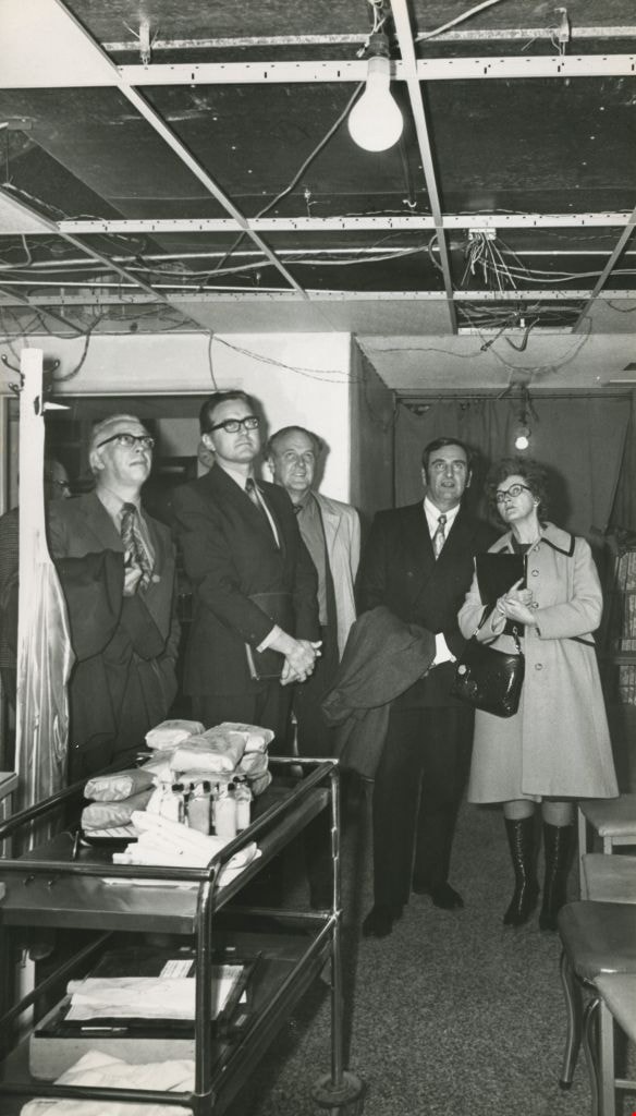
Burnaby General Hospital's emergency ward
https://search.heritageburnaby.ca/link/archivedescription45348
- Repository
- City of Burnaby Archives
- Date
- 1972
- Collection/Fonds
- Columbian Newspaper collection
- Description Level
- Item
- Physical Description
- 1 photograph : b&w ; 24 x 14 cm
- Scope and Content
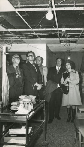
- Photograph of Speaker Gordon Dowding, Chief of Medical Staff Dr. R.E. Harlos, Municipal Affairs Minister Jim Lorimer, Health Minister Dennis Cocke and Education Minister Eileen Dailly visiting Burnaby General Hospital's emergency ward to see just how badly facilities needed to be expanded.
- Repository
- City of Burnaby Archives
- Date
- 1972
- Collection/Fonds
- Columbian Newspaper collection
- Physical Description
- 1 photograph : b&w ; 24 x 14 cm
- Description Level
- Item
- Record No.
- 480-243
- Access Restriction
- No restrictions
- Reproduction Restriction
- No restrictions
- Accession Number
- 2003-02
- Scope and Content
- Photograph of Speaker Gordon Dowding, Chief of Medical Staff Dr. R.E. Harlos, Municipal Affairs Minister Jim Lorimer, Health Minister Dennis Cocke and Education Minister Eileen Dailly visiting Burnaby General Hospital's emergency ward to see just how badly facilities needed to be expanded.
- Names
- Burnaby General Hospital
- Dowding, Gordon
- Harlos, Dr. R.E.
- Lorimer, James G "Jim"
- Cocke, Dennis
- Dailly, Eileen
- Media Type
- Photograph
- Photographer
- King, Basil
- Notes
- Title based on contents of photograph
- Newspaper clipping attached to verso of photograph reads: "Four provincial cabinet ministers Friday visited Burnaby general Hospital's emergency ward to see just how badly facilities need to be expanded. From left, Speaker Gordon Dowding, Chief of Medical Staff Dr. R.E. Harlos, Municipal Affairs Minister Jim Lorimer, Health Minister Dennis Cocke and Education Minister Eileen Dailly get first-hand look at stop-gap expansion, pending approval or otherwise of today's $95 million hospitals bylaw referendum. BGH emergency facilities are being expanded to handle 11 stretcher cases instead of present six."
- Geographic Access
- Kincaid Street
- Street Address
- 3935 Kincaid Street
- Historic Neighbourhood
- Broadview (Historic Neighbourhood)
- Planning Study Area
- Cascade-Schou Area
Images
Burnaby Lake Men’s Community Service Club subseries
https://search.heritageburnaby.ca/link/archivedescription127
- Repository
- City of Burnaby Archives
- Date
- 1936-1955
- Collection/Fonds
- Burnaby Historical Society fonds
- Description Level
- Subseries
- Physical Description
- Textual records
- Scope and Content
- Subseries consists of meeting minutes, incorporation documents, correspondence and pamphlets from the Burnaby Lake Men's Community Service Club. Also included in the subseries is one large framed photograph of the Valleyview Community Centre.
- Repository
- City of Burnaby Archives
- Date
- 1936-1955
- Collection/Fonds
- Burnaby Historical Society fonds
- Physical Description
- Textual records
- Description Level
- Subseries
- Accession Number
- BHS1997-07
- Scope and Content
- Subseries consists of meeting minutes, incorporation documents, correspondence and pamphlets from the Burnaby Lake Men's Community Service Club. Also included in the subseries is one large framed photograph of the Valleyview Community Centre.
- History
- The Burnaby Lake Men’s Community Service Club was incorporated on March 26, 1946. The aims of the club were to: cultivate a desire in our members to be of the greatest service to their community; elevate and reinforce the standards of good citizenship; foster friendship and broaden human sympathy and express them in terms of social helpfulness; and provide for wholesome recreation, education, civic and other leisure-time activities of the community. ccording to a membership drive handout produced in 1951, yearly membership was $1 and in order to be a member you had to: have been a former member; be present active member; be of the male species; or be t least mildly interested in the betterment of the social activities of your community and the promotion of good fellowship. Director of the Department of Education, Henry Hill, was the first president of the Club. Hill was also instrumental in the creation of the Valley View Community Council, which was originally made up of two appointed delegates from the Central Burnaby Ratepayers & Citizen’s Association, the Burnaby Lake Men’s Community Service Club and the Women’s Community Club. The Valley View Community Council became a Society on February 10, 1948. In 1943 Burnaby City Council pledged to help fund at least one Community Centre in each Ward of the Municipality by 50% (up to $2,500 per building). The Club had a plan to provide a Community Centre for the Central Burnaby area as early as 1945 when they visited the site allotted to the cause by the Council of Burnaby on Douglas Road at Ledger Street (later renamed and numbered 4050 Grandview Highway and later called Canada Way). They organized Annual Country Fairs, with the first held in 1944, to raise funds from community members and by November 30, 1946, they had $3,750 “held for the purpose of building a Community Centre.” The building was erected and by December of 1949 it was used for the purpose of holding a Municipal Election.
- Media Type
- Textual Record
- Photograph
- Notes
- Title based on contents of subseries
- PC196, MSS084