Narrow Results By
Subject
- Buildings - Civic - Fire Halls 1
- Buildings - Civic - Museums 1
- Buildings - Commercial 1
- Buildings - Commercial - Stores 1
- Buildings - Residential - Houses 1
- Events 1
- Events - Parades 1
- Geographic Features - Forests 1
- Geographic Features - Lanes 1
- Geographic Features - Neighbourhoods 1
- Geographic Features - Roads 1
- Holidays - Christmas 1
4260 Edmonds St.
https://search.heritageburnaby.ca/link/archivedescription94351
- Repository
- City of Burnaby Archives
- Date
- October 1995
- Collection/Fonds
- Grover, Elliott & Co. Ltd. fonds
- Description Level
- File
- Physical Description
- 26 photographs : col. negatives ; 35 mm
- Scope and Content
- Photographs of the exterior of Lumberland, located at 4260 Edmonds Street (an address that no longer exists) and the surrounding area at Edmonds Street and Kingsway.
- Repository
- City of Burnaby Archives
- Date
- October 1995
- Collection/Fonds
- Grover, Elliott & Co. Ltd. fonds
- Physical Description
- 26 photographs : col. negatives ; 35 mm
- Description Level
- File
- Record No.
- 622-136
- Access Restriction
- No restrictions
- Reproduction Restriction
- No restrictions
- Accession Number
- 2017-39
- Scope and Content
- Photographs of the exterior of Lumberland, located at 4260 Edmonds Street (an address that no longer exists) and the surrounding area at Edmonds Street and Kingsway.
- Subjects
- Buildings - Commercial
- Names
- Lumberland
- Media Type
- Photograph
- Photographer
- Young, Richard
- Notes
- Transcribed title
- Title transcribed from envelope photographs were originally housed in
- File no. 95-358-B
- Sticky note adhered to 622-135-1 print reads: "3) View north east from Edmonds St."
- Sticky note adhered to 622-135-2 print reads: "4) View east along Kingsway"
- Sticky note adhered to 622-135-5 print reads: "8) View south along the east lane"
- Sticky note adhered to 622-135-8 print reads: "2) View south west from Kingsway"
- Sticky note adhered to 622-135-11 print reads: "5) View west along Kingsway"
- Sticky note adhered to 622-135-14 print reads: "1) View south from Kingsway"
- Sticky note adhered to 622-135-18 print reads: "6) View south along Edmonds St."
- Sticky note adhered to 622-135-21 print reads: "7) View north along Edmonds St."
- Geographic Access
- Edmonds Street
- Kingsway
![Burnaby Fire Department Community Day, [2000] thumbnail](/media/hpo/_Data/_Archives_Images/_Unrestricted/535/535-2663-1.jpg?width=280)
Burnaby Fire Department Community Day
https://search.heritageburnaby.ca/link/archivedescription97255
- Repository
- City of Burnaby Archives
- Date
- [2000]
- Collection/Fonds
- Burnaby NewsLeader photograph collection
- Description Level
- File
- Physical Description
- 2 photographs (tiff) : col.
- Scope and Content
- File contains photographs of two children, Harrison Hunter and Isuru Withange, playing in a fire hose and fire extinguishing foam during the Burnaby Fire Department's Community Day at Richmond Park (now Edmonds Park).
- Repository
- City of Burnaby Archives
- Date
- [2000]
- Collection/Fonds
- Burnaby NewsLeader photograph collection
- Physical Description
- 2 photographs (tiff) : col.
- Description Level
- File
- Record No.
- 535-2663
- Access Restriction
- No restrictions
- Reproduction Restriction
- No restrictions
- Accession Number
- 2018-12
- Scope and Content
- File contains photographs of two children, Harrison Hunter and Isuru Withange, playing in a fire hose and fire extinguishing foam during the Burnaby Fire Department's Community Day at Richmond Park (now Edmonds Park).
- Subjects
- Persons - Children
- Events
- Names
- Burnaby Fire Department
- Media Type
- Photograph
- Photographer
- Bartel, Mario
- Notes
- Title based on caption
- Collected by editorial for use in an August 2000 issue of the Burnaby NewsLeader
- Caption from metadata for 535-2663-1: "Harrison Hunter, 5, races through a fire hose to wash off some of the fire extinguishing foam he'd been rolling in at the Burnaby Fire Department's first Community Day at Richmond Park."
- Caption from metadata for 535-2663-2: "Isuru Withange, 8, uses a fire hose to wash off some of the fire extinguishing foam kids were able to frolic in at the Burnaby Fire Department's first Community Day at Richmond Park."
- Geographic Access
- Edmonds Park
- Edmonds Street
- Street Address
- 7435 Edmonds Street
- Historic Neighbourhood
- Edmonds (Historic Neighbourhood)
- Planning Study Area
- Richmond Park Area
Images
![Burnaby Fire Department Community Day, [2000] thumbnail](/media/hpo/_Data/_Archives_Images/_Unrestricted/535/535-2663-1.jpg)
Burnaby - Images of Change - slide presentation
https://search.heritageburnaby.ca/link/museumdescription13116
- Repository
- Burnaby Village Museum
- Date
- February 1978 (date of slide show)
- Collection/Fonds
- Century Park Museum Association fonds
- Description Level
- File
- Physical Description
- 52 photographs : col. slides ; 35 mm
- Scope and Content
- File consists of fifty two slides used for a Hertiage Village Museum presentation titled "Burnaby - Images of Change". The slides were part of a resource kit prepared by "Heritage Village Education" and consist of copies of historical photographs taken between 1891 and 1931. Numbered slides includ…
- Repository
- Burnaby Village Museum
- Collection/Fonds
- Century Park Museum Association fonds
- Description Level
- File
- Physical Description
- 52 photographs : col. slides ; 35 mm
- Scope and Content
- File consists of fifty two slides used for a Hertiage Village Museum presentation titled "Burnaby - Images of Change". The slides were part of a resource kit prepared by "Heritage Village Education" and consist of copies of historical photographs taken between 1891 and 1931. Numbered slides include; "1) Title slide; 2) Mr. and Mrs. S. Shepard Samuel, 1904; 3) The McMurray Family 1907; 4) The Bateman Family; 5) Mr. Alexis Shaw; 6) Dr. R. Ellen Walker; 7) Home of Col. J. Ward on the north side of Burnaby Lake; 8) Cameron home located on New Westminster Road - now Kingsway; 9) Home of L.C. Hill, "Brookfield" 1894; 10) Bernard Hill's home on Burnaby Lake, 1910; 11) Bateman Family residence under construction, 1920; 12) Bateman residence known as "Elworth House" completed in 1922; 13) Early logging operaton in 1890 using oxen and a skid road; 14) Steam donkey and loggers; 15) Cord wood delivery in 1925; 16) L.C. Hill's strawberry farm in 1895; 17) Strawberries being delivered to New Westminster in 1896; 18) Haying operation on Douglas Road in 1906; 19) 1906 haying scene in the Burnaby Lake area; 20) Kingsway store of Mr. C.B. Button, 1904; 21) Model Grocery stroe at Hastings and Sperling in 1920; 22) Dow Grocery store at Hastings and Sperling in 1920; 23) Zebulon Frank's hardware store in 1887 - Vancouver; 24) Inside of a phography shop, 1910- Vancouver; Burnaby's first Municipal Council, 1892; 25) Burnaby's first Municipal Hall opened in 1899; 27) Presbyterian Church in Westminster Road at Central Park, 1896; 28) St. John the Devine Church in 1896; 29) First school in Burnaby near Edmonds and Douglas Road; 30) School Children, 1904; 31) Miss Harriett Woodward's private school near Deer Lake, 1907; 32) Gilmore Avenue School, March 17, 1920; 33) Pupils of Edmonds Street School, 1922; 34) L.C. Hill Family picnic in July 1892; 35) Lewis Family picnic in 1910; 36) Catch of fish from Deer Lake, 1910; 37) Hunting scene in Burnaby area, 1910; 38) Burnaby's first lawn bowling green, 1907; 39) Skating on Deer Lake, 1912; 40) Skating party on Deer Lake in the winter of 1921; 41) Boating on Deer Lake, 1922; 42) Burnaby's first May Day celebration in 1925; 43) May Day, 1926; 44) Westminster to Vancouver Tram, 1892; 45) Interurban powerhouse at Edmonds and Highland Park, 1891; 46) Douglas Road, 1895; 47) Horse team hauling crushed rock for Douglas Road, 1911; 48) Horse and cart passing cleared land; 49) Cyclist, 1912; 50) The Opening of the paved road (Kingsway), 1913; 51) Painting the white line on Kingsway, 1928; 52) First auto in Burnaby circa 1905; 53) Alfred Bingham and his model T. Ford, 1931".
- Creator
- Burnaby Village Museum
- Subjects
- Buildings - Civic - Museums
- Names
- Burnaby Village Museum
- Accession Code
- BV020.5.734
- Access Restriction
- No restrictions
- Reproduction Restriction
- No known restrictions
- Date
- February 1978 (date of slide show)
- Media Type
- Photograph
- Notes
- Title based on contents of file
- Original photograph content ranges between 1891 and 1931.
- Description of slides taken from "Slide indentification" list BV020.5.735
- See also audio recording commentary BV020.5.733
Cemetery site (proposed) - Douglas Road and Edmonds Street
https://search.heritageburnaby.ca/link/archivedescription1067
- Repository
- City of Burnaby Archives
- Date
- 1916
- Collection/Fonds
- City Council and Office of the City Clerk fonds
- Description Level
- File
- Physical Description
- Textual record and cartographic material
- Scope and Content
- File contains correspondence and report on the proposal to create a cemetery site at Douglas Road and Edmonds Street. File also includes a linen plan of the area.
- Repository
- City of Burnaby Archives
- Date
- 1916
- Collection/Fonds
- City Council and Office of the City Clerk fonds
- Physical Description
- Textual record and cartographic material
- Description Level
- File
- Record No.
- 2854
- Accession Number
- 2001-02
- Scope and Content
- File contains correspondence and report on the proposal to create a cemetery site at Douglas Road and Edmonds Street. File also includes a linen plan of the area.
- Media Type
- Textual Record
- Cartographic Material
- Notes
- Plans/maps are located in file and have not been moved to map case.
Comprehensive Development Plans - Bylaw No. 9579, Rezoning Reference # 6/91 (7557 Edmonds Street)
https://search.heritageburnaby.ca/link/archivedescription14147
- Repository
- City of Burnaby Archives
- Date
- 1991
- Collection/Fonds
- City Council and Office of the City Clerk fonds
- Description Level
- File
- Physical Description
- Architectural drawings
- Repository
- City of Burnaby Archives
- Date
- 1991
- Collection/Fonds
- City Council and Office of the City Clerk fonds
- Series
- Bylaws series
- Physical Description
- Architectural drawings
- Description Level
- File
- Record No.
- 17135
- Accession Number
- 2001-01
- Media Type
- Architectural Drawing
Comprehensive Development Plans - Bylaw No. 10043, Rezoning Reference # 60/93 (7555 Edmonds Street)
https://search.heritageburnaby.ca/link/archivedescription14270
- Repository
- City of Burnaby Archives
- Date
- 1994
- Collection/Fonds
- City Council and Office of the City Clerk fonds
- Description Level
- File
- Physical Description
- Architectural drawing
- Repository
- City of Burnaby Archives
- Date
- 1994
- Collection/Fonds
- City Council and Office of the City Clerk fonds
- Series
- Bylaws series
- Physical Description
- Architectural drawing
- Description Level
- File
- Record No.
- 17258
- Accession Number
- 2001-01
- Media Type
- Architectural Drawing
Comprehensive Development Plans - Bylaw No. 10680, Rezoning Reference # 38/97 (21st Avenue and Edmonds Street)
https://search.heritageburnaby.ca/link/archivedescription84401
- Repository
- City of Burnaby Archives
- Date
- 1997
- Collection/Fonds
- City Council and Office of the City Clerk fonds
- Description Level
- File
- Physical Description
- Architectural drawing
- Repository
- City of Burnaby Archives
- Date
- 1997
- Collection/Fonds
- City Council and Office of the City Clerk fonds
- Series
- Bylaws series
- Physical Description
- Architectural drawing
- Description Level
- File
- Record No.
- 51980
- Accession Number
- 2013-28
- Media Type
- Architectural Drawing
Comprehensive Development Plans - Bylaw No. 11459, Rezoning Reference #02-17 (7568 & 7602 Edmonds Street and 7601 Nineteenth Avenue)
https://search.heritageburnaby.ca/link/archivedescription85579
- Repository
- City of Burnaby Archives
- Date
- 2003
- Collection/Fonds
- City Council and Office of the City Clerk fonds
- Description Level
- File
- Physical Description
- Architectural drawing
- Repository
- City of Burnaby Archives
- Date
- 2003
- Collection/Fonds
- City Council and Office of the City Clerk fonds
- Series
- Bylaws series
- Physical Description
- Architectural drawing
- Description Level
- File
- Record No.
- 55872
- Accession Number
- 2013-28
- Media Type
- Architectural Drawing
Comprehensive Development Plans - Bylaw No. 11547, Rezoning Reference #01-38 (6970 21st Avenue and 7017 Edmonds Street)
https://search.heritageburnaby.ca/link/archivedescription85616
- Repository
- City of Burnaby Archives
- Date
- 2004
- Collection/Fonds
- City Council and Office of the City Clerk fonds
- Description Level
- File
- Physical Description
- Architectural drawing
- Repository
- City of Burnaby Archives
- Date
- 2004
- Collection/Fonds
- City Council and Office of the City Clerk fonds
- Series
- Bylaws series
- Physical Description
- Architectural drawing
- Description Level
- File
- Record No.
- 55892
- Accession Number
- 2013-28
- Media Type
- Architectural Drawing
Comprehensive Development Plans - Bylaw No. 11560, Rezoning Reference #03-15 (7487 Edmonds Street)
https://search.heritageburnaby.ca/link/archivedescription85636
- Repository
- City of Burnaby Archives
- Date
- 2003
- Collection/Fonds
- City Council and Office of the City Clerk fonds
- Description Level
- File
- Physical Description
- Architectural drawing
- Repository
- City of Burnaby Archives
- Date
- 2003
- Collection/Fonds
- City Council and Office of the City Clerk fonds
- Series
- Bylaws series
- Physical Description
- Architectural drawing
- Description Level
- File
- Record No.
- 55897
- Accession Number
- 2013-28
- Media Type
- Architectural Drawing
Comprehensive Development Plans - Bylaw No. 11890, Rezoning Reference #05-02b (Oliver Twist Neighbourhood Pub, 7555 Edmonds Street)
https://search.heritageburnaby.ca/link/archivedescription85846
- Repository
- City of Burnaby Archives
- Date
- 2005
- Collection/Fonds
- City Council and Office of the City Clerk fonds
- Description Level
- File
- Physical Description
- Architectural drawing
- Repository
- City of Burnaby Archives
- Date
- 2005
- Collection/Fonds
- City Council and Office of the City Clerk fonds
- Series
- Bylaws series
- Physical Description
- Architectural drawing
- Description Level
- File
- Record No.
- 56482
- Accession Number
- 2013-28
- Media Type
- Architectural Drawing

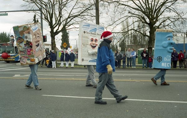
Edmonds parade
https://search.heritageburnaby.ca/link/archivedescription38558
- Repository
- City of Burnaby Archives
- Date
- November 27, 2003
- Collection/Fonds
- Burnaby Historical Society fonds
- Description Level
- File
- Physical Description
- 23 photographs : col. negatives ; 35 mm
- Scope and Content
- Photographs of the first Edmonds Christmas parade as it was seen travelling down Edmonds Street between Canada Way and Mary Avenue on November 27, 2003. Photographs show parade floats and groups walking in the parade with signs and costumes.
- Repository
- City of Burnaby Archives
- Date
- November 27, 2003
- Collection/Fonds
- Burnaby Historical Society fonds
- Subseries
- Pixie McGeachie subseries
- Physical Description
- 23 photographs : col. negatives ; 35 mm
- Description Level
- File
- Record No.
- 460-001
- Access Restriction
- No restrictions
- Reproduction Restriction
- Reproduce for fair dealing purposes only
- Accession Number
- BHS2004-02
- Scope and Content
- Photographs of the first Edmonds Christmas parade as it was seen travelling down Edmonds Street between Canada Way and Mary Avenue on November 27, 2003. Photographs show parade floats and groups walking in the parade with signs and costumes.
- Media Type
- Photograph
- Geographic Access
- Edmonds Street
- Mary Avenue
- Canada Way
- Planning Study Area
- Edmonds Area
Images
Edmonds St + 18th Ave (SW of 16th Street)
https://search.heritageburnaby.ca/link/archivedescription93727
- Repository
- City of Burnaby Archives
- Date
- March 1989
- Collection/Fonds
- Grover, Elliott & Co. Ltd. fonds
- Description Level
- File
- Physical Description
- 14 photographs : col. negatives ; 35 mm
- Scope and Content
- Photographs of the intersections at Edmonds Street and 18th Avenue and Edmonds Street and 16th Avenue and an unidentified residential lane.
- Repository
- City of Burnaby Archives
- Date
- March 1989
- Collection/Fonds
- Grover, Elliott & Co. Ltd. fonds
- Physical Description
- 14 photographs : col. negatives ; 35 mm
- Description Level
- File
- Record No.
- 622-015
- Access Restriction
- No restrictions
- Reproduction Restriction
- No restrictions
- Accession Number
- 2017-39
- Scope and Content
- Photographs of the intersections at Edmonds Street and 18th Avenue and Edmonds Street and 16th Avenue and an unidentified residential lane.
- Media Type
- Photograph
- Notes
- Transcribed title
- Title transcribed from original print envelope
- Photographs 622-015-001 : 622-015-002 depict Edmonds Street and 16th Avenue, facing south
- Photographs 622-015-003 : 622-015-004 depict the view southwest along Edmonds Street
- Photographs 622-015-006 : 622-015-008 depict the view southeast along 16th Street
- Photographs 622-015-009 : 622-015-011 depict the view southwest along 18th Avenue
- Locations were identified using notes on verso of accompanying prints
- Geographic Access
- 18th Avenue
- Edmonds Street
- 16th Avenue
- Historic Neighbourhood
- Edmonds (Historic Neighbourhood)
- Planning Study Area
- Stride Avenue Area
![Fire Hall No. 2, [2001] thumbnail](/media/hpo/_Data/_Archives_Images/_Unrestricted/535/535-1613-3.jpg?width=280)
Fire Hall No. 2
https://search.heritageburnaby.ca/link/archivedescription95781
- Repository
- City of Burnaby Archives
- Date
- [2001]
- Collection/Fonds
- Burnaby NewsLeader photograph collection
- Description Level
- File
- Physical Description
- 12 photographs (tiff) : col.
- Scope and Content
- File contains photographs of Burnaby's Fire Hall No. 2 and its fire fighters at work. Photographs depict fire fighters with record storage; grilling at a barbecue; together in the kitchen; and washing a fire truck. Additional photographs show fire fighting equipment and protective gear.
- Repository
- City of Burnaby Archives
- Date
- [2001]
- Collection/Fonds
- Burnaby NewsLeader photograph collection
- Physical Description
- 12 photographs (tiff) : col.
- Description Level
- File
- Record No.
- 535-1613
- Access Restriction
- No restrictions
- Reproduction Restriction
- No restrictions
- Accession Number
- 2018-12
- Scope and Content
- File contains photographs of Burnaby's Fire Hall No. 2 and its fire fighters at work. Photographs depict fire fighters with record storage; grilling at a barbecue; together in the kitchen; and washing a fire truck. Additional photographs show fire fighting equipment and protective gear.
- Names
- Burnaby Fire Department
- Media Type
- Photograph
- Notes
- Title based on original file name
- Collected by editorial for use in a February 2001 issue of the Burnaby NewsLeader
- Geographic Access
- Edmonds Street
- Street Address
- 7578 Edmonds Street
- Historic Neighbourhood
- Edmonds (Historic Neighbourhood)
- Planning Study Area
- Government Road Area
Images
![Fire Hall No. 2, [2001] thumbnail](/media/hpo/_Data/_Archives_Images/_Unrestricted/535/535-1613-3.jpg)
![Survey and Subdivision plans in New Westminster District Group 1 – Burnaby
, [1909] thumbnail](/media/hpo/_Data/_BVM_Cartographic_Material/1977/1977_0093_0002a_001.jpg?width=280)
Survey and Subdivision plans in New Westminster District Group 1 – Burnaby
https://search.heritageburnaby.ca/link/museumdescription6972
- Repository
- Burnaby Village Museum
- Date
- [1909]
- Collection/Fonds
- Burnaby Village Museum Map collection
- Description Level
- File
- Physical Description
- 6 Plans : blueprint ink on paper + 1 black ink on paper mounted on 2 sides of cardboard 76 cm x 102 cm
- Scope and Content
- Item consists of a large board of three New Westminster District Gp 1 - subdivision plans mounted on one side and three New Westminster District Gp 1 - subdivision plans mounted on the other side with scales ranging from one chain equals one inch to four chains equals one inch. Side A: 1. Bluepri…
- Repository
- Burnaby Village Museum
- Collection/Fonds
- Burnaby Village Museum Map collection
- Description Level
- File
- Physical Description
- 6 Plans : blueprint ink on paper + 1 black ink on paper mounted on 2 sides of cardboard 76 cm x 102 cm
- Material Details
- Scales [1:792] and [1:3168]
- Index number on edge of board reads: "2"
- Scope and Content
- Item consists of a large board of three New Westminster District Gp 1 - subdivision plans mounted on one side and three New Westminster District Gp 1 - subdivision plans mounted on the other side with scales ranging from one chain equals one inch to four chains equals one inch. Side A: 1. Blueprint "Plan, / of Subdivision / of / Blocks 61, 62 and 2 / Lot 30 / Group 1 /N.W.Dist." Plan includes Fulton Street, Edmonds Street and Vancouver Road at the bottom. (Geographic location: Burnaby) 2. Blueprint "Location / for Burnaby Council / of / The West Boundary of Lots 161 & 175 / Group One". Plan includes River Road, North Arm Road, Boundary Rd. Diversion and the North Arm of the Fraser at the bottom. (Geographic location: Burnaby) 3. Blueprint "Survey / of Highway / for / Burnaby Council / Lots 13 & 14 / Group One". Plan includes Armstrong Street, Caribou [sic] Street, Caribou [sic] Road and Brunette River with Lower Dam and Upper Dam. (Geographic location: Burnaby) Side B: 1. Blueprint "Plan of Subdivision / of Lots 1, 2 and 5 / in the Subdivision of / Lot 87, Gr.1 / Also of 20 1/2 acre part / in the North-West portion of / said Lot 87, Gr.1 / New Westminster District". Plan is bordered by Lot 86 / Hastings Road, Esplanade / Burnaby Lake with Nursery Road running east west. Plan is identified as "Albert J. Hill / B.C.LotS. / 25/06/09" (Geographic location: Burnaby) 2. Blueprint "Plan / of / Subdivision of / Portion of / Lot 85, Gp.1, / New Westminster District" Plan is bordered by Douglas Road and Poleline Road and Esplanade / Burnaby Lake with Byrne Drive running through. Plan is identified as "Albert J. Hill / B.C.LotS. / 11/6/09" (Geographic location: Burnaby) 3. "Plan / of Resubdivision / of / Block VIII / In the Subdivision / of Lot 27 / Group 1 / New Westminster District" Annotation in red ink reads: "Original Subdivision Shown in Red". Plan includes an index at the top and is bordered by Block VII / Second Street, Block V. / Third Avenue, Block XI / Fourth Avenue / Block IX / First Street. (Geographic location: Burnaby)
- Creator
- Hill, Albert James
- Accession Code
- HV977.93.2
- Access Restriction
- No restrictions
- Reproduction Restriction
- No known restrictions
- Date
- [1909]
- Media Type
- Cartographic Material
- Scan Resolution
- 300
- Scale
- 72
- Notes
- Title based on contents of file
- Scale is measured in chains. (One chain equals 792 inches)
- The term "Lot" can also refer to a "District Lot”
Images
![Survey and Subdivision plans in New Westminster District Group 1 – Burnaby
, [1909] thumbnail](/media/hpo/_Data/_BVM_Cartographic_Material/1977/1977_0093_0002a_001.jpg)

![Survey and Subdivision plans in New Westminster District Group 1 – Burnaby
, [1908] thumbnail](/media/hpo/_Data/_BVM_Cartographic_Material/1977/1977_0093_0004a_001.jpg?width=280)
Survey and Subdivision plans in New Westminster District Group 1 – Burnaby
https://search.heritageburnaby.ca/link/museumdescription6973
- Repository
- Burnaby Village Museum
- Date
- [1908]
- Collection/Fonds
- Burnaby Village Museum Map collection
- Description Level
- File
- Physical Description
- 10 plans : blueprint ink on paper mounted on 2 sides of cardboard ; 76 cm x 102 cm
- Scope and Content
- Item consists of a large board of four New Westminster District Gp 1 - subdivision plans mounted on one side and six New Westminster District Gp 1 - subdivision plans mounted on the other side. Side A: 1. Blueprint "Plan / of - ReSubdivision / of / Lots 1-18 inclusive / Blocks 20 and 21 / in Sub…
- Repository
- Burnaby Village Museum
- Collection/Fonds
- Burnaby Village Museum Map collection
- Description Level
- File
- Physical Description
- 10 plans : blueprint ink on paper mounted on 2 sides of cardboard ; 76 cm x 102 cm
- Material Details
- Scales [between 1:792 and 1:4752]
- Index number on edge of board reads: "4"
- Scope and Content
- Item consists of a large board of four New Westminster District Gp 1 - subdivision plans mounted on one side and six New Westminster District Gp 1 - subdivision plans mounted on the other side. Side A: 1. Blueprint "Plan / of - ReSubdivision / of / Lots 1-18 inclusive / Blocks 20 and 21 / in Subdivision / of / Lot 53 -Gr.1 / New Westminster District" / "Subdivision Lot Numbers - Shown in Red". Plan is bordered by First Street / Jorgenson's Line / Fourth Avenue and Second Street with Fifith Avenue running through the centre. There is an index in the upper right corner of the plan. Planned is signed by "Peter Byrne" and "William R. Phillips" and dated July 28, 1908. (Geographic location: Burnaby) 2. Blueprint "Plan / of Subdivision / of / Lot 159 / and a Portion of Lot 158 / Group One / New Westminster District". Plan is bordered by Lots 96 and 97; South Wilson Street; North Arm Road and Lot 160 / Power House Road (Lot 155 A). B.C.E.R. Gilley Station is identified in the upper right corner of the plan. (Geographic location: Burnaby) 3. Blueprint plan identified as "Subdvs 10, L 88 and Lot 25, G. 1" Plan identifies Cumberland Street running from top to the bottom and a Ravine running alongside with the Jensen house, stable and barn. (Geographic location: Burnaby) 4. Blueprint Plan of "Lot 153. G. 1 /New Westminster District". Plan identifies the "New Westminster & Vancouver Tramway" and the "New Westminster and Vancouver Road" running through the plan of Lot 53. (Geographic location: Burnaby) Side B: 1. Blueprint plan of "Profile on Proposed North Rd. Diversion". 2. Blueprint plan (no title) showing wood lots north of Burnaby Lake and Brunette River and west of North Road. Various lots are identified as "Heavily Timbered" (Lot 57); "Splendid Fir and Cedar / Heavy Fir etc. / Fine Cedar" (Lots 143, 148); "Rough Light Timber," (Lot 56); "Some Fir and Cedar" (Lot 40). (Geographic location: Burnaby) 3. Blueprint "Plan / of Subdivision / of a Portion / of Lot 87, Gr.1 / New Westminster District". Plan is bordered by Burnaby Lake at the top and Hastings Road / Lot 86 at the bottom and Lot 90 to the east. "Albert J. Hill B.C.LotS." Annotation in ink reads: " J.A. Brownlee, B.C.L.S. / Subdivision / Map 1494 / Bd. 248". Plan is signed by "Peter Byrne, Reeve" (Geographic location: Burnaby) 4. Blueprint plan of Subdivisions along either side of Douglas Road including Lots 117; 119; 74; 80; 79 and 77. (Geographic location: Burnaby) 5. Blueprint "Plan / of / Subdivision of / Lot 27 / in Subdivision / of / Lot 30 / Group One / New Westminster District" Plan is bordered by Lot 26, Lot 28 and Hastings Rd. Lot 27 runs north of Edmonds Street. , "Albert J. Hill, B.C.LotS." (Geographic location: Burnaby) 6. Blueprint plan identified as a "Cultivated Orchard" including the names "W. Grace" and "G. Mead" located north of the North Arm Fraser River and west of "Twentieth Street_ City Boundary". Handwritten annotation in coloured pencil reads: "Portion of Lot 172" (Geographic location: Burnaby)
- Subjects
- Geographic Features - Forests
- Geographic Access
- Cumberland Street
- North Road
- Hastings Street
- Douglas Road
- Accession Code
- HV977.93.4
- Access Restriction
- No restrictions
- Reproduction Restriction
- No known restrictions
- Date
- [1908]
- Media Type
- Cartographic Material
- Historic Neighbourhood
- Burnaby Lake (Historic Neighbourhood)
- Fraser Arm (Historic Neighbourhood)
- Planning Study Area
- Douglas-Gilpin Area
- Burnaby Lake Area
- Scan Resolution
- 300
- Scale
- 72
- Notes
- Title based on contents of file
- Scale is measured in chains. (One chain equals 792 inches)
- The term "Lot" can also refer to a "District Lot”-
Images
![Survey and Subdivision plans in New Westminster District Group 1 – Burnaby
, [1908] thumbnail](/media/hpo/_Data/_BVM_Cartographic_Material/1977/1977_0093_0004a_001.jpg)

![Traffic in Lakeview-Edmonds, [2001] thumbnail](/media/hpo/_Data/_Archives_Images/_Unrestricted/535/535-2959-1.jpg?width=280)
Traffic in Lakeview-Edmonds
https://search.heritageburnaby.ca/link/archivedescription97676
- Repository
- City of Burnaby Archives
- Date
- [2001]
- Collection/Fonds
- Burnaby NewsLeader photograph collection
- Description Level
- File
- Physical Description
- 4 photographs (tiff) : col.
- Scope and Content
- File contains photographs related to transportation and traffic in the Edmonds area of Burnaby. Photographs depict Argus Carriers delivery driver Terry Doyle at work in his delivery truck, and Lidia Rossi, Porcellato, and Muriel Logan, all members of the Lakeview-Edmonds Neighbourhood Association, …
- Repository
- City of Burnaby Archives
- Date
- [2001]
- Collection/Fonds
- Burnaby NewsLeader photograph collection
- Physical Description
- 4 photographs (tiff) : col.
- Description Level
- File
- Record No.
- 535-2959
- Access Restriction
- No restrictions
- Reproduction Restriction
- No restrictions
- Accession Number
- 2018-12
- Scope and Content
- File contains photographs related to transportation and traffic in the Edmonds area of Burnaby. Photographs depict Argus Carriers delivery driver Terry Doyle at work in his delivery truck, and Lidia Rossi, Porcellato, and Muriel Logan, all members of the Lakeview-Edmonds Neighbourhood Association, posing on a road and interacting with traffic at the corner of 6th and Edmonds.
- Media Type
- Photograph
- Photographer
- Bartel, Mario
- Notes
- Title based on caption
- Collected by editorial for use in a November 2001 issue of the Burnaby NewsLeader
- Caption from metadata for 535-2959-1: "Terry Doyle, a delivery driver for Argus Carriers, heads out to the busy streets of the Lower Mainland to deliver packages."
- Caption from metadata for 535-2959-2: "Terry Doyle, a delivery driver for Argus Carriers, says he tries not to bring the stresses of driving around the Lower Mainland home with him."
- Caption from metadata for 535-2959-3: "Lidia Rossi, Sophia Porcellato, and Muriel Logan have formed the Lakeview-Edmonds Neighbourhood Association to discuss ways to keep rat-running traffic out of their neighbourhood."
- Caption from metadata for 535-2959-4: "Lidia Rossi, of the Lakeview-Edmonds Neighborhood Association, motions to a rat-running motorist, at the corner of 6th St. and Edmonds, to stay out of the residential streets."
- Geographic Access
- 6th Street
- Edmonds Street
- Historic Neighbourhood
- Edmonds (Historic Neighbourhood)
- Planning Study Area
- Lakeview-Mayfield Area
Images
![Traffic in Lakeview-Edmonds, [2001] thumbnail](/media/hpo/_Data/_Archives_Images/_Unrestricted/535/535-2959-1.jpg)
![vey and Subdivision plans in New Westminster District Group 1 – Burnaby
, [1900-1910] thumbnail](/media/hpo/_Data/_BVM_Cartographic_Material/1977/1977_0093_0007a_001.jpg?width=280)
vey and Subdivision plans in New Westminster District Group 1 – Burnaby
https://search.heritageburnaby.ca/link/museumdescription6976
- Repository
- Burnaby Village Museum
- Date
- [1900-1910]
- Collection/Fonds
- Burnaby Village Museum Map collection
- Description Level
- File
- Physical Description
- 4 plans : blueprints on paper mounted on 2 sides of cardboard 76 x 102 cm
- Scope and Content
- Item consists of a large board of two New Westminster District plans mounted on one side and two New Westminster District subdivision plans mounted on the other side. Side A: 1. Blueprint "Plan / of Subdivision / of a portion / of / Lot 96 / Group One / New Westminster District / Scale 2 chs = …
- Repository
- Burnaby Village Museum
- Collection/Fonds
- Burnaby Village Museum Map collection
- Description Level
- File
- Physical Description
- 4 plans : blueprints on paper mounted on 2 sides of cardboard 76 x 102 cm
- Material Details
- Scales [between 1:120 and 1:1584]
- Index number on edge of board reads: "7"
- Scope and Content
- Item consists of a large board of two New Westminster District plans mounted on one side and two New Westminster District subdivision plans mounted on the other side. Side A: 1. Blueprint "Plan / of Subdivision / of a portion / of / Lot 96 / Group One / New Westminster District / Scale 2 chs = 1in." (Geographic locaiton: Burnaby) 2. Blueprint "Plan / North Road / from Holmes' Corner, North / Scale 100 ' = 1"" and "Profile on North Road / from / Holmes' Corner, North". The following are identified: Ravine filled, V.W. & Y. Railway, Brunette River, Holmes' Corner, Holmes' Crib, Private Road, North Road, Old Road and New Westminster Municipal Boundary. (Geographic locaiton: Burnaby) Side B: 1. Blueprint "Subdivision / of Blocks 14, 7 and 4 / In the Subdivision / of / Lot 53, Group 1 / New Westminster District / Scale 1 ch = 1 in." Plan also includes two inset Maps showing the location of DL 53 in relation to the City of New Westminster and Vancouver. The subdivision plans identifies: First Avenue, Second Avenue, Third Avenue, Fourth Avenue bordered by Seventeenth Street and Sixteenth Street. (Geographic locaiton: Burnaby) 2. Blueprint with handwritten title "No. 631 / Plan / of / Subdivision / Lots _ see sheets 1-19, 36-53, 69-75.../ Lot 30 Group 1 / ... Scale 2 chs = 1 in." Edmonds Street and Westminster & Vancouver Tramway are identified along with Walter Street, Kemp Street, Fortune Street, Alice Street, Henry Street, Beatrice Street and Humphries Avenue. (Geographic locaiton: Burnaby)
- Accession Code
- HV977.93.7
- Access Restriction
- No restrictions
- Reproduction Restriction
- No known restrictions
- Date
- [1900-1910]
- Media Type
- Cartographic Material
- Scan Resolution
- 300
- Scale
- 72
- Notes
- Title based on contents of file Scale is measured in chains and feet (One chain equals 792 inches)
- The term "Lot" can also refer to a "District Lot"
Images
![vey and Subdivision plans in New Westminster District Group 1 – Burnaby
, [1900-1910] thumbnail](/media/hpo/_Data/_BVM_Cartographic_Material/1977/1977_0093_0007a_001.jpg)

![Vicki Kreuzer, [2005] thumbnail](/media/hpo/_Data/_Archives_Images/_Unrestricted/535/535-1954-1.jpg?width=280)
Vicki Kreuzer
https://search.heritageburnaby.ca/link/archivedescription96271
- Repository
- City of Burnaby Archives
- Date
- [2005]
- Collection/Fonds
- Burnaby NewsLeader photograph collection
- Description Level
- File
- Physical Description
- 2 photographs (tiff) : col.
- Scope and Content
- File contains photographs of Vicki Kreuzer and Loonie House Market. Photographs depict Kreuzer holding up drug pipes in front of a market on Edmonds Street and confronting the owner of the market.
- Repository
- City of Burnaby Archives
- Date
- [2005]
- Collection/Fonds
- Burnaby NewsLeader photograph collection
- Physical Description
- 2 photographs (tiff) : col.
- Description Level
- File
- Record No.
- 535-1954
- Access Restriction
- No restrictions
- Reproduction Restriction
- No restrictions
- Accession Number
- 2018-12
- Scope and Content
- File contains photographs of Vicki Kreuzer and Loonie House Market. Photographs depict Kreuzer holding up drug pipes in front of a market on Edmonds Street and confronting the owner of the market.
- Subjects
- Buildings - Commercial - Stores
- Media Type
- Photograph
- Photographer
- Bartel, Mario
- Notes
- Title based on caption
- Collected by editorial for use in a February 2005 issue of the Burnaby NewsLeader
- Caption from metadata for 535-1954-1: "Vicki Kreuzer holds up crack pipes she says can be readily bought at a discount store on Edmonds St, making it difficult to rid the Burnaby neighbourhood of drug addicts and crime."
- Caption from metadata for 535-1954-2: "Vicki Kreuzer, right, confronts the owner of the Looniehouse Market in Burnaby's Edmonds neighbourhood, where she says drug addicts can easily buy crack pipes. She says she's asked the owner to stop selling the pipes, and she won't shop there until they're no longer available."
- Geographic Access
- Edmonds Street
- Historic Neighbourhood
- Edmonds (Historic Neighbourhood)
- Planning Study Area
- Richmond Park Area
Images
![Vicki Kreuzer, [2005] thumbnail](/media/hpo/_Data/_Archives_Images/_Unrestricted/535/535-1954-1.jpg)