![Ball thirty-three at the Inter-City Golf Driving Range, [201-] thumbnail](/media/hpo/_Data/_Archives_Images/_Unrestricted/550/557-023.jpg?width=280)
Ball thirty-three at the Inter-City Golf Driving Range
https://search.heritageburnaby.ca/link/archivedescription78772
- Repository
- City of Burnaby Archives
- Date
- [201-]
- Collection/Fonds
- Walker family fonds
- Description Level
- Item
- Physical Description
- 1 photograph (jpeg) : col. ; 314 dpi
- Scope and Content
- Photograph of "ball thirty-three" at the Inter-City Golf Driving Range in Burnaby.
- Repository
- City of Burnaby Archives
- Date
- [201-]
- Collection/Fonds
- Walker family fonds
- Physical Description
- 1 photograph (jpeg) : col. ; 314 dpi
- Description Level
- Item
- Record No.
- 557-023
- Access Restriction
- No restrictions
- Reproduction Restriction
- No restrictions
- Accession Number
- 2013-15
- Scope and Content
- Photograph of "ball thirty-three" at the Inter-City Golf Driving Range in Burnaby.
- Subjects
- Recreational Activities - Golf
- Media Type
- Photograph
- Notes
- Transcribed title
- Geographic Access
- 10th Avenue
- Historic Neighbourhood
- Edmonds (Historic Neighbourhood)
- Planning Study Area
- Edmonds Area
Images
![Ball thirty-three at the Inter-City Golf Driving Range, [201-] thumbnail](/media/hpo/_Data/_Archives_Images/_Unrestricted/550/557-023.jpg)
![Inter-City Golf Driving Range, [201-] thumbnail](/media/hpo/_Data/_Archives_Images/_Unrestricted/550/557-041.jpg?width=280)
Inter-City Golf Driving Range
https://search.heritageburnaby.ca/link/archivedescription78791
- Repository
- City of Burnaby Archives
- Date
- [201-]
- Collection/Fonds
- Walker family fonds
- Description Level
- Item
- Physical Description
- 1 photograph (jpeg) : col. ; 314 dpi
- Scope and Content
- Photograph of what appears to be ball thirty-three at the Inter-City Golf Driving Range in Burnaby.
- Repository
- City of Burnaby Archives
- Date
- [201-]
- Collection/Fonds
- Walker family fonds
- Physical Description
- 1 photograph (jpeg) : col. ; 314 dpi
- Description Level
- Item
- Record No.
- 557-041
- Access Restriction
- No restrictions
- Reproduction Restriction
- No restrictions
- Accession Number
- 2013-15
- Scope and Content
- Photograph of what appears to be ball thirty-three at the Inter-City Golf Driving Range in Burnaby.
- Subjects
- Recreational Activities - Golf
- Media Type
- Photograph
- Notes
- Title based on contents of photograph
- Geographic Access
- 10th Avenue
- Historic Neighbourhood
- Edmonds (Historic Neighbourhood)
- Planning Study Area
- Edmonds Area
Images
![Inter-City Golf Driving Range, [201-] thumbnail](/media/hpo/_Data/_Archives_Images/_Unrestricted/550/557-041.jpg)

John & Hattie Standish Residence
https://search.heritageburnaby.ca/link/landmark607
- Repository
- Burnaby Heritage Planning
- Description
- Residential building.
- Associated Dates
- c.1912
- Street View URL
- Google Maps Street View
- Repository
- Burnaby Heritage Planning
- Geographic Access
- Edmonds Street
- Associated Dates
- c.1912
- Description
- Residential building.
- Heritage Value
- This square, two-storey house displays vertical proportions, with a pyramidal roof and central dormer. It features narrow double-hung windows, lapped siding on the first storey, and shingle siding on the second divided by a belt course, and has retained a high degree of original integrity. It was built for John Albert Standish (1862-1913), a farmer who left this home to his wife, Hattie and their children after his death.
- Locality
- Edmonds
- Historic Neighbourhood
- Edmonds (Historic Neighbourhood)
- Planning Study Area
- Edmonds Area
- Area
- 367.94
- Contributing Resource
- Building
- Ownership
- Private
- Street Address
- 7408 Edmonds Street
- Street View URL
- Google Maps Street View
Images


Edmonds Neighbourhood
https://search.heritageburnaby.ca/link/landmark758
- Repository
- Burnaby Heritage Planning
- Associated Dates
- 1905-1924
- Heritage Value
- From The British Columbian, March 19, 1912: "On the fringe of New Westminster there is…a suburban townsite in Edmonds. During the past eighteen months it has grown and prospered quite phenomenally. It is ideally situated, is in easy communication with New Westminster by two car lines. Its climate is clear and bracing, being exceptionally free from the fogs that are more or less prevalent along the river section and gulf shore...Edmonds, in fact, is one of the finest residential parts of the province. This is fast becoming known and appreciated beyond its borders. Elegant and substantial residences are being erected in various parts, and stores are being put up in convenient localities. The new municipal building is one of the finest in British Columbia for so young a municipality."
- Historic Neighbourhood
- Edmonds (Historic Neighbourhood)
- Planning Study Area
- Edmonds Area
Images


East Burnaby Neighbourhood
https://search.heritageburnaby.ca/link/landmark773
- Repository
- Burnaby Heritage Planning
- Associated Dates
- 1905-1924
- Heritage Value
- According to the 1911 December 26 edition of The British Columbian: Optimism is the word that applies to the whole community of East Burnaby. The many improvements carried out by the council during the past two years had been the means of making East Burnaby a thriving settlement, and hence one and all are optimistic as to its future. In the clearing and building line, many fine new homes are being erected...Real estate values have advanced with the times, and a notable feature is the number of better-class houses that are being built in this locality, which proves that East Burnaby is becoming very much alive and elevated.
- Historic Neighbourhood
- East Burnaby (Historic Neighbourhood)
- Planning Study Area
- Edmonds Area
Images


Edmonds Street Neighbourhood
https://search.heritageburnaby.ca/link/landmark827
- Repository
- Burnaby Heritage Planning
- Associated Dates
- 1955-2008
- Heritage Value
- The Edmonds Street Neighbourhood is part of the larger Edmonds Town Centre - one of four Town Centres in Burnaby. This neighbourhood is considered to be primarily residential, but a strong local commercial component developed along Edmonds and Kingsway.
- Historic Neighbourhood
- Edmonds (Historic Neighbourhood)
- Planning Study Area
- Edmonds Area
Images

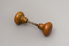
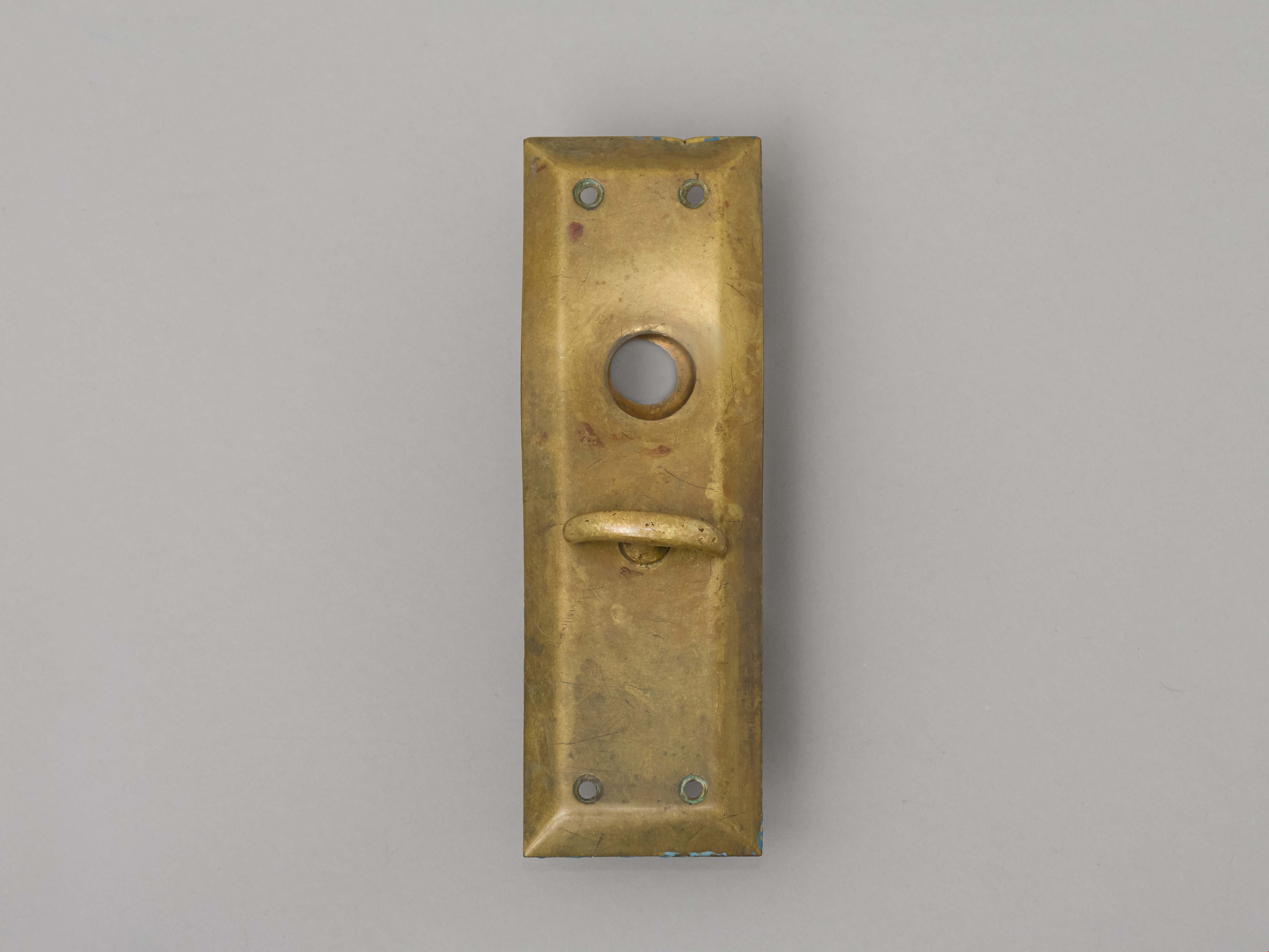
doorknob and door plate
https://search.heritageburnaby.ca/link/museumartifact84042
- Repository
- Burnaby Village Museum
- Accession Code
- BV014.34.1
- Description
- Doorknob and door plate from Edmonds School.
- Object History
- Doorknob and door plate were found in the fire remains of Edmonds School in 1989.
- Category
- 01. Built Environment Objects
- Classification
- Building Components - - Finish Hardware
- Object Term
- Doorknob
- Subjects
- Building Components
- Buildings - Schools
- Names
- Edmonds Community School
- Historic Neighbourhood
- Edmonds (Historic Neighbourhood)
- Planning Study Area
- Edmonds Area
Images

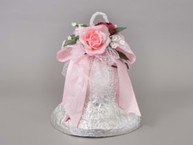
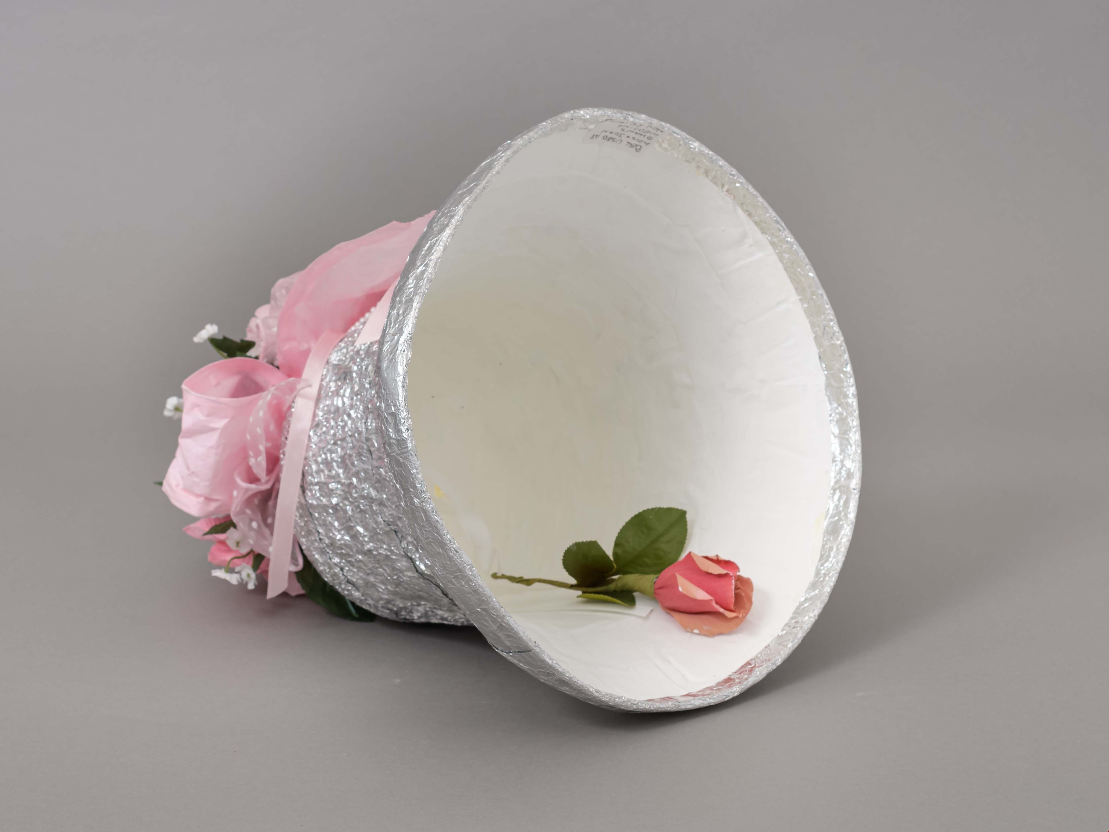
Bell
https://search.heritageburnaby.ca/link/museumartifact90700
- Repository
- Burnaby Village Museum
- Accession Code
- BV019.53.3
- Description
- Wedding bell decoration, wrapped in tin foil. The top of the bell has a hook made from white pipe cleaners. There are white and pink silk flowers and green leaves at the top of the bell.
- Object History
- This wedding bell was passed down and used a several family weddings since the 1940s.
- Category
- 02. Furnishings
- Classification
- Decorative Furnishings
- Object Term
- Decoration
- Colour
- Silver
- Pink
- Green
- White
- Subjects
- Ceremonies - Weddings
- Historic Neighbourhood
- Edmonds (Historic Neighbourhood)
- Planning Study Area
- Edmonds Area
Images

Bygones of Burnaby : an anecdotal history
https://search.heritageburnaby.ca/link/museumlibrary5462
- Repository
- Burnaby Village Museum
- Author
- McGeachie, Pixie, 1921-
- Publication Date
- 1976
- c1975
- Call Number
- 971.133 MCG COPY 4
- Repository
- Burnaby Village Museum
- Collection
- Digital Reference Collection
- Material Type
- Book
- Call Number
- 971.133 MCG COPY 4
- Author
- McGeachie, Pixie, 1921-
- Place of Publication
- Burnaby, B.C.
- Publisher
- Century Park Museum Association
- Publication Date
- 1976
- c1975
- Physical Description
- 108 p. : ill. ; 23 cm.
- Library Subject (LOC)
- Burnaby (B.C.)--History
- Notes
- 4 copies held: copy 4.
Digital Books

Pioneer tales of Burnaby
https://search.heritageburnaby.ca/link/museumlibrary5860
- Repository
- Burnaby Village Museum
- Collection
- Digital Reference Collection
- Reference Collection
- Material Type
- Book
- ISBN
- 096928280x
- Call Number
- 971.133 SON COPY 4
- Contributor
- Sone, Michael
- Place of Publication
- Burnaby, B.C.
- Publisher
- Corporation of the District of Burnaby
- Publication Date
- c1987
- Physical Description
- 495 p. : ill. ; 31 cm.
- Inscription
- "TR687 - Bryburgh" / handprinted in pencil on frontend page
- Library Subject (LOC)
- Pioneers--British Columbia--Burnaby
- Frontier and pioneer life
- Biography
- Object History
- Early Burnaby as recalled by the settlers themselves who arrived from every corner of the world between 1888 and 1930, some witnessing incorporation of the district in 1892, all seeking a better life for themselves and especially for their children, all helping transform the wilderness into the modern municipality of today.
- Notes
- "Editor Michael Sone".
- Includes index.
- 4 copies held: copy 4
Images

Digital Books

Tram memories : in celebration of the restoration of Interurban 1223
https://search.heritageburnaby.ca/link/museumlibrary5863
- Repository
- Burnaby Village Museum
- Author
- McGeachie, Pixie, 1921-
- Publication Date
- c2007
- Call Number
- 388.460971 TRA
- Repository
- Burnaby Village Museum
- Collection
- Digital Reference Collection
- Reference Collection
- Material Type
- Book
- Call Number
- 388.460971 TRA
- Author
- McGeachie, Pixie, 1921-
- Contributor
- Friends of Interurban 1223
- Place of Publication
- Burnaby
- Publisher
- City of Burnaby
- Publication Date
- c2007
- Printer
- City of Burnaby Printshop
- Physical Description
- 91 p. : ill., map ;,20 cm
- Library Subject (LOC)
- Electric railroads
- Local transit
- Street-railroads
- Transportation
- Geographic Access
- Vancouver
- Name Access
- British Columbia Electric Railway Company
- Notes
- Editor : Pixie McGeachie
Images

Digital Books
![Gilley Brothers Logging team, [1895]. . thumbnail](/media/hpo/_Data/_Archives_Images/_Unrestricted/371/461-003.jpg?width=280)
Vancouver Road (Kingsway)
https://search.heritageburnaby.ca/link/landmark729
- Repository
- Burnaby Heritage Planning
- Associated Dates
- 1860
- Heritage Value
- The street we know as Kingsway is one of the legacies of the Royal Engineers' military defences for New Westminster. The fear of an American attack prompted the construction of the False Creek trail - later known as Vancouver Road and now Kingsway - in 1860 to connect the capital city to the ice-free salt water harbour at English Bay.
- Historic Neighbourhood
- Central Park (Historic Neighbourhood)
- Edmonds (Historic Neighbourhood)
- Planning Study Area
- Maywood Area
- Marlborough Area
- Windsor Area
- Kingsway-Beresford Area
- Stride Avenue Area
- Edmonds Area
Images
![Gilley Brothers Logging team, [1895]. . thumbnail](/media/hpo/_Data/_Archives_Images/_Unrestricted/371/461-003.jpg)
![William Brenchley house, [between 1890 and 1895] (date of original), copied 1985 thumbnail](/media/hpo/_Data/_Archives_Images/_Unrestricted/126/146-001.jpg?width=280)
William Brenchley house
https://search.heritageburnaby.ca/link/archivedescription34863
- Repository
- City of Burnaby Archives
- Date
- [between 1890 and 1895] (date of original), copied 1985
- Collection/Fonds
- Burnaby Historical Society fonds
- Description Level
- Item
- Physical Description
- 1 photograph : b&w ; 8.8 x 12.5 cm print
- Scope and Content
- Photograph of the exterior of the house of William Brenchley at 10th Avenue and Kingsway, northeast corner. A number of people are standing outside. Partially cleared land can be seen in the background.
- Repository
- City of Burnaby Archives
- Date
- [between 1890 and 1895] (date of original), copied 1985
- Collection/Fonds
- Burnaby Historical Society fonds
- Subseries
- W.E. Brenchley subseries
- Physical Description
- 1 photograph : b&w ; 8.8 x 12.5 cm print
- Description Level
- Item
- Record No.
- 146-001
- Access Restriction
- No restrictions
- Reproduction Restriction
- No known restrictions
- Accession Number
- BHS1985-16
- Scope and Content
- Photograph of the exterior of the house of William Brenchley at 10th Avenue and Kingsway, northeast corner. A number of people are standing outside. Partially cleared land can be seen in the background.
- Subjects
- Buildings - Residential - Houses
- Media Type
- Photograph
- Notes
- Title based on contents of photograph
- Geographic Access
- 10th Avenue
- Kingsway
- Historic Neighbourhood
- Edmonds (Historic Neighbourhood)
- Planning Study Area
- Edmonds Area
Images
![William Brenchley house, [between 1890 and 1895] (date of original), copied 1985 thumbnail](/media/hpo/_Data/_Archives_Images/_Unrestricted/126/146-001.jpg)
![William Brenchley farm, [between 1890 and 1895] (date of original), copied 1985 thumbnail](/media/hpo/_Data/_Archives_Images/_Unrestricted/126/146-002.jpg?width=280)
William Brenchley farm
https://search.heritageburnaby.ca/link/archivedescription34864
- Repository
- City of Burnaby Archives
- Date
- [between 1890 and 1895] (date of original), copied 1985
- Collection/Fonds
- Burnaby Historical Society fonds
- Description Level
- Item
- Physical Description
- 1 photograph : b&w ; 8.8 x 12.5 cm print
- Scope and Content
- Photograph of a farm hand and horse team inside a large stump, taken on William Brenchley's farm. The farm was located at the northeast corner of Kingsway and 10th Avenue.
- Repository
- City of Burnaby Archives
- Date
- [between 1890 and 1895] (date of original), copied 1985
- Collection/Fonds
- Burnaby Historical Society fonds
- Subseries
- W.E. Brenchley subseries
- Physical Description
- 1 photograph : b&w ; 8.8 x 12.5 cm print
- Description Level
- Item
- Record No.
- 146-002
- Access Restriction
- No restrictions
- Reproduction Restriction
- No known restrictions
- Accession Number
- BHS1985-16
- Scope and Content
- Photograph of a farm hand and horse team inside a large stump, taken on William Brenchley's farm. The farm was located at the northeast corner of Kingsway and 10th Avenue.
- Media Type
- Photograph
- Photographer
- Thompson, S.J.
- Notes
- Title based on contents of photograph
- Geographic Access
- 10th Avenue
- Kingsway
- Historic Neighbourhood
- Edmonds (Historic Neighbourhood)
- Planning Study Area
- Edmonds Area
Images
![William Brenchley farm, [between 1890 and 1895] (date of original), copied 1985 thumbnail](/media/hpo/_Data/_Archives_Images/_Unrestricted/126/146-002.jpg)

Charles R. Shaw House
https://search.heritageburnaby.ca/link/landmark525
- Repository
- Burnaby Heritage Planning
- Description
- The Charles R. Shaw House is a one and one-half storey plus basement wood-frame late Victorian era residence, located on the grounds of the Normanna Rest Home development in East Burnaby, near its original location on this site. Originally a modest vernacular Victorian structure, it has been enlarg…
- Associated Dates
- 1891
- Formal Recognition
- Heritage Designation, Community Heritage Register
- Other Names
- Charles R. & Mary Shaw House
- Street View URL
- Google Maps Street View
- Repository
- Burnaby Heritage Planning
- Other Names
- Charles R. & Mary Shaw House
- Geographic Access
- 12th Avenue
- 4th Street
- 13th Avenue
- Associated Dates
- 1891
- Formal Recognition
- Heritage Designation, Community Heritage Register
- Enactment Type
- Bylaw No. 10739
- Enactment Date
- 06/04/1998
- Description
- The Charles R. Shaw House is a one and one-half storey plus basement wood-frame late Victorian era residence, located on the grounds of the Normanna Rest Home development in East Burnaby, near its original location on this site. Originally a modest vernacular Victorian structure, it has been enlarged and embellished through later additions.
- Heritage Value
- The Shaw House is one of the oldest surviving houses in Burnaby, and is valued as a representation of a typical vernacular pioneer house in Burnaby, and a rare survivor from the late Victorian era. The original portion of the house displays a simplicity of form and detail consistent with early local construction, while the later additions display a more sophisticated approach. Originally built in 1891, this house is valued for its association with first owner, Charles R. Shaw (1834-1916) and Mary D. Shaw (1848-1897), one of Burnaby’s earliest settlers. Born in England, Shaw immigrated to Toronto in 1869, and relocated to New Westminster in 1889, where he worked as an employee of the Mechanic's Mill Company, an early woodworking plant. After moving to Burnaby, he was unanimously elected by acclamation as first reeve (mayor) of the new municipality in 1892. In 1894, Shaw sold his house and farm and moved his family to Kamloops due to his wife Mary's failing health. After Mary died in 1897, the Shaw family returned to Toronto. The Shaw House is additionally valued for its association with a later owner, James Brookes (1884-1953), founder of James Brookes Woodworking Ltd., a mill that was a major employer in East Burnaby. Brookes bought and renovated the house in 1917. In 1927, he built a much larger house on the property (now demolished), and the original house was moved to the corner of the property to serve as a gardener's cottage for Brookes' estate. The additions made to the house at this time employed sash and milled products produced by the Brookes plant. Although altered, this Victorian era residence remains largely intact, with Brookes’s later additions.
- Defining Elements
- Key elements that define the heritage character of the Shaw House include its: - modest vernacular residential form, scale and massing, as exemplified by its one and one-half storey plus basement height, front gabled roof, shed roofed verandah and asymmetrical plan - asymmetrical front entrance - cladding: horizontal wooden drop siding on the original portion of the house; cedar shingles on additions; decorative octagonal cedar shingles in the front gable; original decorated bargeboards at front, with cut-out details - later renovations to the front verandah and side addition which resulted in a partially glazed porch entrance and addition with large window assemblies - square verandah columns - irregular fenestration: double-hung wooden-sash windows in a variety of configurations such as 6-over-1 and 4-over-1 windows in the original portion of the house, 12-over-1 windows, and one 24-over-1 window in the front addition - small window at front entry - fifteen-pane French front entry door - internal red brick chimney with corbelled cap
- Historic Neighbourhood
- East Burnaby (Historic Neighbourhood)
- Planning Study Area
- Edmonds Area
- Function
- Primary Historic--Single Dwelling
- Primary Current--Single Dwelling
- Community
- Burnaby
- Cadastral Identifier
- 003-253-848
- Boundaries
- The Shaw House is comprised of a single residential lot located at 7725 Fourth Street (legal address), Burnaby
- Area
- 9199.27
- Contributing Resource
- Building
- Ownership
- Private
- Names
- Shaw, Charles R
- Street Address
- 7725 4th Street
- Street View URL
- Google Maps Street View
Images


![Subdivision plans in New Westminster District Group 1 – Burnaby
, [1891-1910] thumbnail](/media/hpo/_Data/_BVM_Cartographic_Material/1977/1977_0093_0015a_001.jpg?width=280)
Subdivision plans in New Westminster District Group 1 – Burnaby
https://search.heritageburnaby.ca/link/museumdescription6984
- Repository
- Burnaby Village Museum
- Date
- [1891-1910]
- Collection/Fonds
- Burnaby Village Museum Map collection
- Description Level
- File
- Physical Description
- 4 plans : blueprint ink on paper mounted on 2 sides of cardboard 76 x 102 cm
- Scope and Content
- Item consists of a large board of two New Westminster District Gp 1 - subdivision plans mounted on one side and two New Westminster District Gp 1 - subdivision plans mounted on the other side. Side A: 1. Blueprint "Plan / of Subdivision / of / Lot 29 / Group One / New Westminster District / Scal…
- Repository
- Burnaby Village Museum
- Collection/Fonds
- Burnaby Village Museum Map collection
- Description Level
- File
- Physical Description
- 4 plans : blueprint ink on paper mounted on 2 sides of cardboard 76 x 102 cm
- Material Details
- Scales [between 1:600 and 1:7920]
- Index number on edge of board reads: "15"
- Scope and Content
- Item consists of a large board of two New Westminster District Gp 1 - subdivision plans mounted on one side and two New Westminster District Gp 1 - subdivision plans mounted on the other side. Side A: 1. Blueprint "Plan / of Subdivision / of / Lot 29 / Group One / New Westminster District / Scale 4 chs = 1 in. / Map No 564, Depostd '91". "Reichenbach", dep. Aug. 1891. (Geographic location: Burnaby) 2. Blueprint "Plan / of Subdivision / of / Lot 93 / Group One / New Westminster District / Scale 4 chs = 1 in. / Map No 284". (Geographic location: Burnaby) Side B: 1. Blueprint "Plan / of Subdivision / of a Portion / of / [Lot A of ] Lot 29 / Group One / New Westminster District / Scale 50 ' = 1"" Plan is bordered by Douglas Road to the east, False Creek Trail to the south and Lot 30 to the north. (Geographic location: Burnaby) 2. Blueprint "Plan / of Central Park / and Vicinity / Scale 10 chs = 1 in." (Geographic location: Burnaby)
- Accession Code
- HV977.93.15
- Access Restriction
- No restrictions
- Reproduction Restriction
- No known restrictions
- Date
- [1891-1910]
- Media Type
- Cartographic Material
- Historic Neighbourhood
- Edmonds (Historic Neighbourhood)
- Planning Study Area
- Edmonds Area
- Scan Resolution
- 300
- Scale
- 72
- Notes
- Title based on contents of file
- Scale is measured in chains and feet. (One chain equals 792 inches)
- The term "Lot" can also refer to a "District Lot”
Images
![Subdivision plans in New Westminster District Group 1 – Burnaby
, [1891-1910] thumbnail](/media/hpo/_Data/_BVM_Cartographic_Material/1977/1977_0093_0015a_001.jpg)


East Burnaby Neighbourhood
https://search.heritageburnaby.ca/link/landmark739
- Repository
- Burnaby Heritage Planning
- Associated Dates
- 1892
- Heritage Value
- The original route of the Central Park tramline wound through New Westminster and then came up 6th Street to Edmonds, along Edmonds and across Westminster Road (Kingsway) to Highland Park and into Vancouver. Consequently, the first area of the future Municipality to attract settlers in any number was around 6th Street and Edmonds. By 1892, about 200 people had established homes in East Burnaby.
- Historic Neighbourhood
- Edmonds (Historic Neighbourhood)
- Planning Study Area
- Edmonds Area
Images

![Subdivision plans in New Westminster District Group 1 – Burnaby
, [1893-1910] thumbnail](/media/hpo/_Data/_BVM_Cartographic_Material/1977/1977_0093_0016a_001.jpg?width=280)
Subdivision plans in New Westminster District Group 1 – Burnaby
https://search.heritageburnaby.ca/link/museumdescription6985
- Repository
- Burnaby Village Museum
- Date
- [1893-1910]
- Collection/Fonds
- Burnaby Village Museum Map collection
- Description Level
- File
- Physical Description
- 4 plans : blueprint ink on paper mounted on 2 sides of cardboard 76 x 102 cm
- Scope and Content
- Item consists of a large board of two New Westminster District Gp 1 - subdivision plans mounted on one side and two New Westminster District Gp 1 - subdivision plans mounted on the other side. Side A: 1. Blueprint "Plan / of Subdivision / of / Lot 6 / Group One / New Westminster District / Scale…
- Repository
- Burnaby Village Museum
- Collection/Fonds
- Burnaby Village Museum Map collection
- Description Level
- File
- Physical Description
- 4 plans : blueprint ink on paper mounted on 2 sides of cardboard 76 x 102 cm
- Material Details
- Scales [between 1:1584 and 1:3960]
- Index number on edge of board reads: "16"
- Scope and Content
- Item consists of a large board of two New Westminster District Gp 1 - subdivision plans mounted on one side and two New Westminster District Gp 1 - subdivision plans mounted on the other side. Side A: 1. Blueprint "Plan / of Subdivision / of / Lot 6 / Group One / New Westminster District / Scale 5 chs = 1 in. / Map No 748" (Geographic location: Burnaby) 2. Blueprint "Plan / of Subdivision / of a Portion / of / Lot 29 / Group One / New Westminster Dist. / Scale 2 chs = 1 in. / Map No." Name identified in Block H is "Reichenbach" (Geographic location: Burnaby) Side B: 1. Blueprint "Plan / of Subdivision / of North 1/2 of Lot 80 / Group One / New Westminster District / Scale 3 chs = 1 in. / Map No 719" Plan is signed by: "Garden, Hermon & Burwell P.L.S. / Vancouver Jan. 23rd, 1893" (Geographic location: Burnaby) 2. Blueprint "Plan / of Subdivision / of Lot 79, Gr.1 / New Westminster Dist. / Scale 4 chas = 1 in. / Map No 536" Plan is signed by "Garden Hermon & Burwell / Provincial Land Surveyors". (Geographic location: Burnaby)
- Creator
- Garden, Hermon and Burwell
- Accession Code
- HV977.93.16
- Access Restriction
- No restrictions
- Reproduction Restriction
- No known restrictions
- Date
- [1893-1910]
- Media Type
- Cartographic Material
- Historic Neighbourhood
- Edmonds (Historic Neighbourhood)
- Burnaby Lake (Historic Neighbourhood)
- Planning Study Area
- Douglas-Gilpin Area
- Edmonds Area
- Cameron Area
- Scan Resolution
- 300
- Scale
- 72
- Notes
- Title based on contents of file
- Scale is measured in chains. (One chain equals 792 inches)
- The term "Lot" can also refer to a "District Lot”
Images
![Subdivision plans in New Westminster District Group 1 – Burnaby
, [1893-1910] thumbnail](/media/hpo/_Data/_BVM_Cartographic_Material/1977/1977_0093_0016a_001.jpg)


Burnaby's first Public School
https://search.heritageburnaby.ca/link/archivedescription35881
- Repository
- City of Burnaby Archives
- Date
- February 1894 (date of original), copied 1986
- Collection/Fonds
- Burnaby Historical Society fonds
- Description Level
- Item
- Physical Description
- 1 photograph : b&w ; 12.7 x 17.8 cm print
- Scope and Content
- Photograph of school officials standing on the steps of the first public school in Burnaby, Douglas Road and Edmonds Street. Left to right: William McDermott (school trustee), Ethel Lepage (first teacher), Lancelot Grimmer (school trustee), and Bernard Hill (school board chairman and secretary). Th…
- Repository
- City of Burnaby Archives
- Date
- February 1894 (date of original), copied 1986
- Collection/Fonds
- Burnaby Historical Society fonds
- Subseries
- Pioneer Tales subseries
- Physical Description
- 1 photograph : b&w ; 12.7 x 17.8 cm print
- Description Level
- Item
- Record No.
- 204-740
- Access Restriction
- No restrictions
- Reproduction Restriction
- No known restrictions
- Accession Number
- BHS1988-03
- Scope and Content
- Photograph of school officials standing on the steps of the first public school in Burnaby, Douglas Road and Edmonds Street. Left to right: William McDermott (school trustee), Ethel Lepage (first teacher), Lancelot Grimmer (school trustee), and Bernard Hill (school board chairman and secretary). The school was called Burnaby School from 1894 to 1896, and then East Burnaby School from 1896 to 1907. The present day address of the site is 7376 Canada Way.
- Subjects
- Officials
- Occupations - Teachers
- Media Type
- Photograph
- Notes
- Title based on contents of photograph
- Geographic Access
- Canada Way
- Street Address
- 7376 Canada Way
- Historic Neighbourhood
- Edmonds (Historic Neighbourhood)
- Planning Study Area
- Edmonds Area
Images

East Burnaby School (Edmonds Street School)
https://search.heritageburnaby.ca/link/landmark735
- Repository
- Burnaby Heritage Planning
- Geographic Access
- Canada Way
- Associated Dates
- 1894
- Heritage Value
- One of the first tasks of Burnaby's Municipal Government upon its incorporation was to lobby for a public school in Burnaby. By 1893, land on Douglas Road near Edmonds was donated and the new school was built in 1893. The one-room school opened on January 22, 1894 with 29 students under the charge of teacher, Ethel LePage. The School has been known as the Burnaby School (until1896), and then East Burnaby School from 1896 to 1907 and finally, Edmonds Street School.
- Historic Neighbourhood
- Edmonds (Historic Neighbourhood)
- Planning Study Area
- Edmonds Area
- Street Address
- 7376 Canada Way
- Street View URL
- Google Maps Street View
Images