Narrow Results By
Subject
- Building Components 1
- Buildings - Commercial 1
- Buildings - Commercial - General Stores 1
- Buildings - Commercial - Grocery Stores 1
- Buildings - Industrial - Factories 1
- Buildings - Recreational - Community Halls 1
- Buildings - Religious - Churches 1
- Buildings - Residential - Houses 1
- Buildings - Schools 6
- Ceremonies - Weddings 1
- Documentary Artifacts - Programs 1
- Events - May Day 1
Creator
- Barrowclough, George Alfred 1
- Bridgman's Studio Limited 1
- British Columbia Underwriters' Association 2
- Burnett and McGugan B.C. Land Surveyors, New Westminster 2
- Dalton & Eveleigh 1
- Edmonds Junior Secondary School 2
- Friends of Interurban 1223 1
- Garden, Hermon and Burwell 1
- Hadwin, Juanita 7
- King Studio Photographers 1
- McGeachie, Pixie, 1921- 2
- McGugan, Donald Johnston 1
![Subdivision plans in New Westminster District Group 1 – Burnaby
, [1893-1910] thumbnail](/media/hpo/_Data/_BVM_Cartographic_Material/1977/1977_0093_0016a_001.jpg?width=280)
Subdivision plans in New Westminster District Group 1 – Burnaby
https://search.heritageburnaby.ca/link/museumdescription6985
- Repository
- Burnaby Village Museum
- Date
- [1893-1910]
- Collection/Fonds
- Burnaby Village Museum Map collection
- Description Level
- File
- Physical Description
- 4 plans : blueprint ink on paper mounted on 2 sides of cardboard 76 x 102 cm
- Scope and Content
- Item consists of a large board of two New Westminster District Gp 1 - subdivision plans mounted on one side and two New Westminster District Gp 1 - subdivision plans mounted on the other side. Side A: 1. Blueprint "Plan / of Subdivision / of / Lot 6 / Group One / New Westminster District / Scale…
- Repository
- Burnaby Village Museum
- Collection/Fonds
- Burnaby Village Museum Map collection
- Description Level
- File
- Physical Description
- 4 plans : blueprint ink on paper mounted on 2 sides of cardboard 76 x 102 cm
- Material Details
- Scales [between 1:1584 and 1:3960]
- Index number on edge of board reads: "16"
- Scope and Content
- Item consists of a large board of two New Westminster District Gp 1 - subdivision plans mounted on one side and two New Westminster District Gp 1 - subdivision plans mounted on the other side. Side A: 1. Blueprint "Plan / of Subdivision / of / Lot 6 / Group One / New Westminster District / Scale 5 chs = 1 in. / Map No 748" (Geographic location: Burnaby) 2. Blueprint "Plan / of Subdivision / of a Portion / of / Lot 29 / Group One / New Westminster Dist. / Scale 2 chs = 1 in. / Map No." Name identified in Block H is "Reichenbach" (Geographic location: Burnaby) Side B: 1. Blueprint "Plan / of Subdivision / of North 1/2 of Lot 80 / Group One / New Westminster District / Scale 3 chs = 1 in. / Map No 719" Plan is signed by: "Garden, Hermon & Burwell P.L.S. / Vancouver Jan. 23rd, 1893" (Geographic location: Burnaby) 2. Blueprint "Plan / of Subdivision / of Lot 79, Gr.1 / New Westminster Dist. / Scale 4 chas = 1 in. / Map No 536" Plan is signed by "Garden Hermon & Burwell / Provincial Land Surveyors". (Geographic location: Burnaby)
- Creator
- Garden, Hermon and Burwell
- Accession Code
- HV977.93.16
- Access Restriction
- No restrictions
- Reproduction Restriction
- No known restrictions
- Date
- [1893-1910]
- Media Type
- Cartographic Material
- Historic Neighbourhood
- Edmonds (Historic Neighbourhood)
- Burnaby Lake (Historic Neighbourhood)
- Planning Study Area
- Douglas-Gilpin Area
- Edmonds Area
- Cameron Area
- Scan Resolution
- 300
- Scale
- 72
- Notes
- Title based on contents of file
- Scale is measured in chains. (One chain equals 792 inches)
- The term "Lot" can also refer to a "District Lot”
Images
![Subdivision plans in New Westminster District Group 1 – Burnaby
, [1893-1910] thumbnail](/media/hpo/_Data/_BVM_Cartographic_Material/1977/1977_0093_0016a_001.jpg)

![Thomas and Bertha Shankie outside Barker Avenue home, [1920] (date of original), copied [2016] thumbnail](/media/hpo/_Data/_BVM_Images/2016/201600430011_001.jpg?width=280)
Thomas and Bertha Shankie outside Barker Avenue home
https://search.heritageburnaby.ca/link/museumdescription4110
- Repository
- Burnaby Village Museum
- Date
- [1920] (date of original), copied [2016]
- Collection/Fonds
- Esther Love Stanley fonds
- Description Level
- Item
- Physical Description
- 1 photograph (tiff)
- Scope and Content
- Photograph of the Shankie family's one story house on Barker Avenue and garden. Bertha and Thomas Shankie are standing on the front walkway. Thomas is holding a cat. A neighbouring house can be glimpsed on the right side of the photograph.
- Repository
- Burnaby Village Museum
- Collection/Fonds
- Esther Love Stanley fonds
- Description Level
- Item
- Physical Description
- 1 photograph (tiff)
- Scope and Content
- Photograph of the Shankie family's one story house on Barker Avenue and garden. Bertha and Thomas Shankie are standing on the front walkway. Thomas is holding a cat. A neighbouring house can be glimpsed on the right side of the photograph.
- Geographic Access
- Barker Avenue
- Street Address
- 5515 Barker Avenue
- Accession Code
- BV016.43.11
- Access Restriction
- No restrictions
- Reproduction Restriction
- May be restricted by third party rights
- Date
- [1920] (date of original), copied [2016]
- Media Type
- Photograph
- Historic Neighbourhood
- Central Park (Historic Neighbourhood)
- Planning Study Area
- Edmonds Area
- Notes
- Title based on contents of photograph.
- Image is from a binder of family history. Binder 1, orange cover "Old Stanley Family Photo / Old Shankie Family Photos / War Photos - Echo Photos".
- Digital image created from orginal photograph by donor
Images
![Thomas and Bertha Shankie outside Barker Avenue home, [1920] (date of original), copied [2016] thumbnail](/media/hpo/_Data/_BVM_Images/2016/201600430011_001.jpg)
![Tramline tracks, [1905] thumbnail](/media/hpo/_Data/_BVM_Images/1990/199500100001.jpg?width=280)
Tramline tracks
https://search.heritageburnaby.ca/link/museumdescription3361
- Repository
- Burnaby Village Museum
- Date
- [1905]
- Collection/Fonds
- Burnaby Village Museum Photograph collection
- Description Level
- Item
- Physical Description
- 1 photograph : b&w ; 15 x 25.5 cm print
- Scope and Content
- Photograph of a British Columbia Electric Railway Company tramline track on Sixth Street and Twelfth Avenue. George Leaf's General Store, located at 7745 Sixth Street is visible on the left and Cliff's Car Factory located at 7730 Sixth Street is visible on the right. George Leaf's store burned down…
- Repository
- Burnaby Village Museum
- Collection/Fonds
- Burnaby Village Museum Photograph collection
- Description Level
- Item
- Physical Description
- 1 photograph : b&w ; 15 x 25.5 cm print
- Scope and Content
- Photograph of a British Columbia Electric Railway Company tramline track on Sixth Street and Twelfth Avenue. George Leaf's General Store, located at 7745 Sixth Street is visible on the left and Cliff's Car Factory located at 7730 Sixth Street is visible on the right. George Leaf's store burned down in 1913. The Car factory was established in 1902 and sometime in the 1920s, it became James Brookes Woodworking Plant.
- Subjects
- Transportation - Electric Railroads
- Buildings - Commercial - General Stores
- Buildings - Industrial - Factories
- Geographic Access
- 6th Street
- 12th Avenue
- Street Address
- 7730 6th Street
- 7745 6th Street
- Accession Code
- BV995.10.1
- Access Restriction
- No restrictions
- Date
- [1905]
- Media Type
- Photograph
- Historic Neighbourhood
- East Burnaby (Historic Neighbourhood)
- Planning Study Area
- Edmonds Area
- Notes
- Title based on contents of photograph
Images
![Tramline tracks, [1905] thumbnail](/media/hpo/_Data/_BVM_Images/1990/199500100001.jpg)
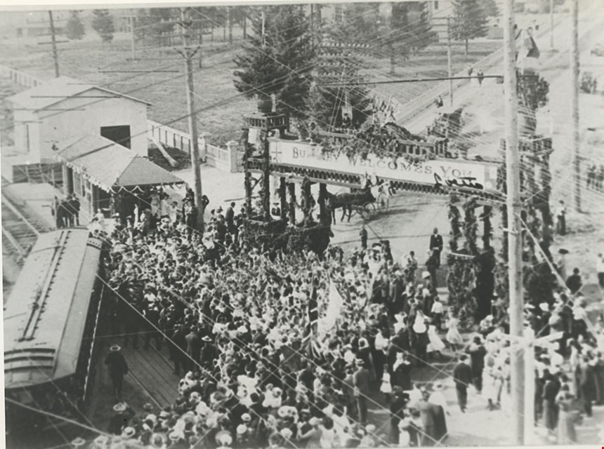
Welcome arch for the Duke of Connaught
https://search.heritageburnaby.ca/link/museumdescription716
- Repository
- Burnaby Village Museum
- Date
- 1912 (date of original), copied 1976
- Collection/Fonds
- Burnaby Village Museum Photograph collection
- Description Level
- Item
- Physical Description
- 1 photograph : b&w print
- Scope and Content
- Photograph of the welcome arch erected at Edmonds and Kingsway to welcome Prince Arthur, Duke of Connaught during his visit to Burnaby. People are milling around the arch, dressed in their finery. The Connaught tram car that Prince Arthur arrived in is parked on the right. Prince Arthur was Governo…
- Repository
- Burnaby Village Museum
- Collection/Fonds
- Burnaby Village Museum Photograph collection
- Description Level
- Item
- Physical Description
- 1 photograph : b&w print
- Scope and Content
- Photograph of the welcome arch erected at Edmonds and Kingsway to welcome Prince Arthur, Duke of Connaught during his visit to Burnaby. People are milling around the arch, dressed in their finery. The Connaught tram car that Prince Arthur arrived in is parked on the right. Prince Arthur was Governor General of Canada at this time.
- Subjects
- Transportation - Electric Railroads
- Geographic Access
- Edmonds Street
- Kingsway
- Accession Code
- HV976.42.1
- Access Restriction
- No restrictions
- Reproduction Restriction
- May be restricted by third party rights
- Date
- 1912 (date of original), copied 1976
- Media Type
- Photograph
- Historic Neighbourhood
- Edmonds (Historic Neighbourhood)
- Planning Study Area
- Edmonds Area
- Richmond Park Area
- Related Material
- To see photographs from the visit of the Duke of Connaught in 1912, see HV976.152.2 - .5
- Scan Resolution
- 600
- Scan Date
- 2023-06-20
- Notes
- Title based on contents of photograph
Images