Narrow Results By
Subject
- Advertising Medium - Signs and Signboards 1
- Aerial Photographs 3
- Buildings - Civic - Hospitals 2
- Buildings - Commercial - Restaurants 1
- Buildings - Heritage 13
- Buildings - Industrial - Factories 1
- Buildings - Residential 1
- Buildings - Residential - Apartments 3
- Buildings - Residential - Houses 4
- Buildings - Residential - Seniors Housing 7
- Clothing - Uniforms 2
- Documentary Artifacts - Postcards 2
Person / Organization
- Beamish, Agnes 1
- British Columbia Electric Railway Company 1
- Cariboo Hill Secondary School 1
- Cliff's Can Factory 1
- Coutts, Mel 1
- Coutts, Stewart "Stu" 1
- Derrick, Brenda 1
- Derrick, Ethel Beamish 1
- George Derby Health Centre 3
- Groves, Ada Evelyn Lewis 1
- Hunter, Beatrice "Bea" Carpenter 1
- Jackson, Grace 1

Arrow Neon Sign
https://search.heritageburnaby.ca/link/landmark861
- Repository
- Burnaby Heritage Planning
- Description
- Commercial building.
- Associated Dates
- 1961
- Other Names
- Lost in the 50's Drive-in
- Street View URL
- Google Maps Street View
- Repository
- Burnaby Heritage Planning
- Other Names
- Lost in the 50's Drive-in
- Geographic Access
- Edmonds Street
- Associated Dates
- 1961
- Description
- Commercial building.
- Heritage Value
- The Arrow Neon Sign was built in 1961 by the Neonette Sign Company of New Westminster when this property was opened as the Tomahawk Drive-in Restaurant. The restaurant was later known as Lindy's Burger and in 1990, the business was renamed Lost in the 50's Drive-in. It stands 20-foot tall and is composed of a large double-sided hollow steel panel serpentine arrow mounted on a pole supporting a lexan sign panel measuring approximately 8 feet wide by 4 feet tall. The sign was designed with three illuminated features: a round lamp at the top of the pole, a double-sided rectangular fluorescent sign panel box, and two double-sided rows of orange neon arrows that follow the large serpentine arrow. The Arrow Neon Sign remains as a rare surviving example of neon sign art in the city and is the only historic neon sign in South Burnaby. The sign has gained prominence over the years as it has been associated with this small iconic drive-in which has also been utilized as a set for film production. Additionally, the drive-in has played a prominent role in the Edmonds community as a popular setting for recent "Show and Shine" participants to park their classic cars.
- Locality
- Edmonds
- Historic Neighbourhood
- East Burnaby (Historic Neighbourhood)
- Planning Study Area
- Lakeview-Mayfield Area
- Builder
- Neonette Sign Company
- Community
- Burnaby
- Contributing Resource
- Structure
- Ownership
- Public (local)
- Street Address
- 7741 Edmonds Street
- Street View URL
- Google Maps Street View
Images


Cariboo-Armstrong Neighbourhood
https://search.heritageburnaby.ca/link/landmark825
- Repository
- Burnaby Heritage Planning
- Associated Dates
- 1955-2008
- Heritage Value
- The Cariboo-Armstrong Neighbourhood was mainly subdivided in the 1950s during the major building boom in Burnaby throughout the post-war years. Considered a primarily residential area, the neighbourhood has quick and convenient access to major highways and roads as well as being bordered to the north by the George Derby Conservation area.
- Historic Neighbourhood
- East Burnaby (Historic Neighbourhood)
- Planning Study Area
- Cariboo-Armstrong Area
Images


Cariboo Hill Secondary School
https://search.heritageburnaby.ca/link/landmark837
- Repository
- Burnaby Heritage Planning
- Geographic Access
- 16th Avenue
- Associated Dates
- 1961
- Heritage Value
- By 1961, three new elementary schools had been built in the northeast section of Burnaby - Armstrong, Seaforth, and Lyndhurst. With growing enrolment at each, too many students were required to travel a farther distance to attend Edmonds Junior High School. As a result, the Cariboo Hill Secondary School was built in 1961 and opened with 410 students. Its peak enrolment was during the 1974 school year when over 1100 students attended. Additions to the school were made in 1969, 1971 and 1974.
- Historic Neighbourhood
- East Burnaby (Historic Neighbourhood)
- Planning Study Area
- Cariboo-Armstrong Area
- Street Address
- 8580 16th Avenue
- Street View URL
- Google Maps Street View
Images


Second Street Neighbourhood
https://search.heritageburnaby.ca/link/landmark826
- Repository
- Burnaby Heritage Planning
- Associated Dates
- 1955-2008
- Heritage Value
- Second Street had its origins in the 1910-1920 era and the Second Street Elementary School was built in 1928. Substantial new housing was built in the late 1940s and 1950s and infilling occurred during the 1960s and 1970s. By the 1980s, the neighbourhood was primarily a single family area with a small number of multi-family buildings.
- Historic Neighbourhood
- East Burnaby (Historic Neighbourhood)
- Planning Study Area
- Second Street Area
Images

![335 16th Avenue, [between 1950 and 1954] (date of original), copied 1991 thumbnail](/media/hpo/_Data/_Archives_Images/_Unrestricted/370/370-430.jpg?width=280)
335 16th Avenue
https://search.heritageburnaby.ca/link/archivedescription37842
- Repository
- City of Burnaby Archives
- Date
- [between 1950 and 1954] (date of original), copied 1991
- Collection/Fonds
- Burnaby Historical Society fonds
- Description Level
- Item
- Physical Description
- 1 photograph : b&w ; 2.6 x 4.6 cm print on contact sheet 20.6 x 26.7 cm
- Scope and Content
- Photograph of 335 16th Avenue (later renumbered 8029 16th Avenue), the home of Mel and Lois Coutts from 1948 to 1955.
- Repository
- City of Burnaby Archives
- Date
- [between 1950 and 1954] (date of original), copied 1991
- Collection/Fonds
- Burnaby Historical Society fonds
- Subseries
- Burnaby Image Bank subseries
- Physical Description
- 1 photograph : b&w ; 2.6 x 4.6 cm print on contact sheet 20.6 x 26.7 cm
- Description Level
- Item
- Record No.
- 370-430
- Access Restriction
- No restrictions
- Reproduction Restriction
- No restrictions
- Accession Number
- BHS1999-03
- Scope and Content
- Photograph of 335 16th Avenue (later renumbered 8029 16th Avenue), the home of Mel and Lois Coutts from 1948 to 1955.
- Subjects
- Buildings - Residential - Houses
- Media Type
- Photograph
- Notes
- Title based on contents of photograph
- 1 b&w copy negative accompanying
- Negative has a pink cast
- Geographic Access
- 16th Avenue
- Street Address
- 8029 16th Avenue
- Historic Neighbourhood
- East Burnaby (Historic Neighbourhood)
- Planning Study Area
- Second Street Area
Images
![335 16th Avenue, [between 1950 and 1954] (date of original), copied 1991 thumbnail](/media/hpo/_Data/_Archives_Images/_Unrestricted/370/370-430.jpg)
Aerial photograph of Burnaby
https://search.heritageburnaby.ca/link/archivedescription84913
- Repository
- City of Burnaby Archives
- Date
- 1963
- Collection/Fonds
- Allan Amundsen collection
- Description Level
- Item
- Physical Description
- 1 photograph : b&w ; 22.5 x 22.5 cm
- Scope and Content
- Aerial photograph of East Burnaby up to North Road and south of the Trans Canada Highway.
- Repository
- City of Burnaby Archives
- Date
- 1963
- Collection/Fonds
- Allan Amundsen collection
- Physical Description
- 1 photograph : b&w ; 22.5 x 22.5 cm
- Description Level
- Item
- Record No.
- 561-031
- Access Restriction
- In Archives only
- Reproduction Restriction
- No reproduction permitted
- Accession Number
- 2014-08
- Scope and Content
- Aerial photograph of East Burnaby up to North Road and south of the Trans Canada Highway.
- Subjects
- Aerial Photographs
- Media Type
- Photograph
- Photographer
- Province of British Columbia
- Notes
- Title based on contents of photograph
- This photo is indentified as BC5062:70 and connects with B.C. air photograph BC5062:21 to the west and BC5062:71 to the east
- Historic Neighbourhood
- East Burnaby (Historic Neighbourhood)
- Planning Study Area
- Cameron Area
- Cariboo-Armstrong Area
Aerial photograph of Burnaby and Coquitlam
https://search.heritageburnaby.ca/link/archivedescription84914
- Repository
- City of Burnaby Archives
- Date
- 1963
- Collection/Fonds
- Allan Amundsen collection
- Description Level
- Item
- Physical Description
- 1 photograph : b&w ; 22.5 x 22.5 cm
- Scope and Content
- Aerial photograph of East Burnaby and Coquitlam with North Road running through the centre.
- Repository
- City of Burnaby Archives
- Date
- 1963
- Collection/Fonds
- Allan Amundsen collection
- Physical Description
- 1 photograph : b&w ; 22.5 x 22.5 cm
- Description Level
- Item
- Record No.
- 561-032
- Access Restriction
- In Archives only
- Reproduction Restriction
- No reproduction permitted
- Accession Number
- 2014-08
- Scope and Content
- Aerial photograph of East Burnaby and Coquitlam with North Road running through the centre.
- Subjects
- Aerial Photographs
- Media Type
- Photograph
- Photographer
- Province of British Columbia
- Notes
- Title based on contents of photograph
- This photo is indentified as BC5062:71 and connects with B.C. air photograph BC5062:70 to the west
- Historic Neighbourhood
- East Burnaby (Historic Neighbourhood)
- Planning Study Area
- Cameron Area
- Cariboo-Armstrong Area
![Bea Carpenter, [1951 or 1952] (date of original), copied 1991 thumbnail](/media/hpo/_Data/_Archives_Images/_Unrestricted/370/370-122.jpg?width=280)
Bea Carpenter
https://search.heritageburnaby.ca/link/archivedescription37534
- Repository
- City of Burnaby Archives
- Date
- [1951 or 1952] (date of original), copied 1991
- Collection/Fonds
- Burnaby Historical Society fonds
- Description Level
- Item
- Physical Description
- 1 photograph : b&w ; 2.8 x 3.8 cm print on contact sheet 20.2 x 25.3 cm
- Scope and Content
- Photograph of Bea Carpenter standing beside a car (a 1950 Studebaker) in front of the George Derby Health Centre. She wearing her nurse's uniform.
- Repository
- City of Burnaby Archives
- Date
- [1951 or 1952] (date of original), copied 1991
- Collection/Fonds
- Burnaby Historical Society fonds
- Subseries
- Burnaby Image Bank subseries
- Physical Description
- 1 photograph : b&w ; 2.8 x 3.8 cm print on contact sheet 20.2 x 25.3 cm
- Description Level
- Item
- Record No.
- 370-122
- Access Restriction
- No restrictions
- Reproduction Restriction
- No restrictions
- Accession Number
- BHS1999-03
- Scope and Content
- Photograph of Bea Carpenter standing beside a car (a 1950 Studebaker) in front of the George Derby Health Centre. She wearing her nurse's uniform.
- Media Type
- Photograph
- Notes
- Title based on contents of photograph
- 1 b&w copy negative accompanying
- Geographic Access
- Cumberland Street
- Street Address
- 7550 Cumberland Street
- Historic Neighbourhood
- East Burnaby (Historic Neighbourhood)
- Planning Study Area
- Cariboo-Armstrong Area
Images
![Bea Carpenter, [1951 or 1952] (date of original), copied 1991 thumbnail](/media/hpo/_Data/_Archives_Images/_Unrestricted/370/370-122.jpg)
![Betty Massey and cannas plant, [between 1949 and 1953] (date of original), copied 2014 thumbnail](/media/hpo/_Data/_Archives_Images/_Unrestricted/580/581-001.jpg?width=280)
Betty Massey and cannas plant
https://search.heritageburnaby.ca/link/archivedescription88395
- Repository
- City of Burnaby Archives
- Date
- [between 1949 and 1953] (date of original), copied 2014
- Collection/Fonds
- James Massey family fonds
- Description Level
- Item
- Physical Description
- 1 photograph (tiff) : sepia ; 600 dpi
- Scope and Content
- Photograph of a large cannas plant in the garden at Robert Burnaby Park. The woman standing to the right of the cannas plant may be one of James Massey's daughters.
- Repository
- City of Burnaby Archives
- Date
- [between 1949 and 1953] (date of original), copied 2014
- Collection/Fonds
- James Massey family fonds
- Physical Description
- 1 photograph (tiff) : sepia ; 600 dpi
- Description Level
- Item
- Record No.
- 581-001
- Access Restriction
- No restrictions
- Reproduction Restriction
- May be restricted by third party rights
- Accession Number
- 2014-34
- Scope and Content
- Photograph of a large cannas plant in the garden at Robert Burnaby Park. The woman standing to the right of the cannas plant may be one of James Massey's daughters.
- Subjects
- Geographic Features - Gardens
- Media Type
- Photograph
- Notes
- Title based on contents of photograph
- Historic Neighbourhood
- East Burnaby (Historic Neighbourhood)
- Planning Study Area
- Lakeview-Mayfield Area
Images
![Betty Massey and cannas plant, [between 1949 and 1953] (date of original), copied 2014 thumbnail](/media/hpo/_Data/_Archives_Images/_Unrestricted/580/581-001.jpg)
![Betty with cannas plant, [195-] (date of original), copied 2014 thumbnail](/media/hpo/_Data/_Archives_Images/_Unrestricted/580/581-008.jpg?width=280)
Betty with cannas plant
https://search.heritageburnaby.ca/link/archivedescription88402
- Repository
- City of Burnaby Archives
- Date
- [195-] (date of original), copied 2014
- Collection/Fonds
- James Massey family fonds
- Description Level
- Item
- Physical Description
- 1 photograph (tiff) : sepia ; 600 dpi
- Scope and Content
- Photograph of Betty Massey standing next to a cannas plant in the garden of Robert Burnaby Park.
- Repository
- City of Burnaby Archives
- Date
- [195-] (date of original), copied 2014
- Collection/Fonds
- James Massey family fonds
- Physical Description
- 1 photograph (tiff) : sepia ; 600 dpi
- Description Level
- Item
- Record No.
- 581-008
- Access Restriction
- No restrictions
- Reproduction Restriction
- No reproduction permitted
- Accession Number
- 2014-34
- Scope and Content
- Photograph of Betty Massey standing next to a cannas plant in the garden of Robert Burnaby Park.
- Subjects
- Geographic Features - Gardens
- Names
- Massey, Betty
- Media Type
- Photograph
- Notes
- Title based on contents of photograph
- Historic Neighbourhood
- East Burnaby (Historic Neighbourhood)
- Planning Study Area
- Lakeview-Mayfield Area
Images
![Betty with cannas plant, [195-] (date of original), copied 2014 thumbnail](/media/hpo/_Data/_Archives_Images/_Unrestricted/580/581-008.jpg)
![Burnaby Lake Interurban, [before 1954] thumbnail](/media/hpo/_Data/_Archives_Images/_Unrestricted/316/328-001.jpg?width=280)
Burnaby Lake Interurban
https://search.heritageburnaby.ca/link/archivedescription37174
- Repository
- City of Burnaby Archives
- Date
- [before 1954]
- Collection/Fonds
- Burnaby Historical Society fonds
- Description Level
- Item
- Physical Description
- 1 photograph : b&w ; 10 x 13 cm print
- Scope and Content
- Photograph of the Burnaby Lake Interurban in the snow. The house in the background is 2231 Fareham Street, a short street that ran behind Elwell and the tram tracks about midway between the Cumberland Road and Hill Street Stations. This rail line route is now the route of Highway 1 through Burnaby.…
- Repository
- City of Burnaby Archives
- Date
- [before 1954]
- Collection/Fonds
- Burnaby Historical Society fonds
- Subseries
- Photographs subseries
- Physical Description
- 1 photograph : b&w ; 10 x 13 cm print
- Description Level
- Item
- Record No.
- 328-001
- Access Restriction
- No restrictions
- Reproduction Restriction
- Reproduce for fair dealing purposes only
- Accession Number
- BHS1996-14
- Scope and Content
- Photograph of the Burnaby Lake Interurban in the snow. The house in the background is 2231 Fareham Street, a short street that ran behind Elwell and the tram tracks about midway between the Cumberland Road and Hill Street Stations. This rail line route is now the route of Highway 1 through Burnaby. The uppermost window in the house was the donor's bedroom.
- Subjects
- Transportation - Electric Railroads
- Media Type
- Photograph
- Notes
- Title based on contents of photograph
- Geographic Access
- Fareham Avenue
- Historic Neighbourhood
- East Burnaby (Historic Neighbourhood)
- Planning Study Area
- Cariboo-Armstrong Area
Images
![Burnaby Lake Interurban, [before 1954] thumbnail](/media/hpo/_Data/_Archives_Images/_Unrestricted/316/328-001.jpg)
![Cannas plant, [between 1950 and 1953] (date of original), copied 2014 thumbnail](/media/hpo/_Data/_Archives_Images/_Unrestricted/580/581-002.jpg?width=280)
Cannas plant
https://search.heritageburnaby.ca/link/archivedescription88396
- Repository
- City of Burnaby Archives
- Date
- [between 1950 and 1953] (date of original), copied 2014
- Collection/Fonds
- James Massey family fonds
- Description Level
- Item
- Physical Description
- 1 photograph (tiff) : sepia ; 600 dpi
- Scope and Content
- Photograph of a large cannas plant in the garden at Robert Burnaby Park. James Massey worked as the caretaker of Robert Burnaby Park and created extensive gardens with inspiration from his brother who was the caretaker of Queens Park in Vancouver.
- Repository
- City of Burnaby Archives
- Date
- [between 1950 and 1953] (date of original), copied 2014
- Collection/Fonds
- James Massey family fonds
- Physical Description
- 1 photograph (tiff) : sepia ; 600 dpi
- Description Level
- Item
- Record No.
- 581-002
- Access Restriction
- No restrictions
- Reproduction Restriction
- May be restricted by third party rights
- Accession Number
- 2014-34
- Scope and Content
- Photograph of a large cannas plant in the garden at Robert Burnaby Park. James Massey worked as the caretaker of Robert Burnaby Park and created extensive gardens with inspiration from his brother who was the caretaker of Queens Park in Vancouver.
- Subjects
- Geographic Features - Gardens
- Media Type
- Photograph
- Notes
- Title based on contents of photograph
- 1 b&w copy negative accompanying was also digitized
- Historic Neighbourhood
- East Burnaby (Historic Neighbourhood)
- Planning Study Area
- Lakeview-Mayfield Area
Images
![Cannas plant, [between 1950 and 1953] (date of original), copied 2014 thumbnail](/media/hpo/_Data/_Archives_Images/_Unrestricted/580/581-002.jpg)
Copies of photographs from Esther (Love) Stanley albums
https://search.heritageburnaby.ca/link/museumdescription10003
- Repository
- Burnaby Village Museum
- Date
- [1915-1950] (date of originals), copied 1989
- Collection/Fonds
- Burnaby Village Museum fonds
- Description Level
- File
- Physical Description
- 36 photographs : b&w negatives ; 35 mm
- Scope and Content
- Photographs copied from various photograph albums including; Albert Paker, George Love, Gordon Love and Esther (Love) Stanley. Content includes: Love family in front of the piano inside parlour; Love family members with musical instruments inside parlour; Ben Brandrith and Robert Love in uniforms; …
- Repository
- Burnaby Village Museum
- Collection/Fonds
- Burnaby Village Museum fonds
- Series
- Jesse Love farmhouse series
- Subseries
- Love family photographs subseries
- Description Level
- File
- Physical Description
- 36 photographs : b&w negatives ; 35 mm
- Scope and Content
- Photographs copied from various photograph albums including; Albert Paker, George Love, Gordon Love and Esther (Love) Stanley. Content includes: Love family in front of the piano inside parlour; Love family members with musical instruments inside parlour; Ben Brandrith and Robert Love in uniforms; unidentified Asian man in field with hoe and young trees behind him; wedding cake from Frank Charles Stanley and Esther Love's wedding; land clearing for Love farmhouse; Jesse Love feeding chickens; Jesse and Hannah (Girlie) Love in hats outside on Love farm; large picnic on grass; four generations of Love family members; gatherings of Love family members outside; Love family posed in a car inside a studio (Will, Sarah, George, Phoebe and Martha); Leonard Love dressed as a boy scout; Martha (Dot) with children; Love family members celebrate centennial; Jesse Love and Martha (Dot) Love outside Love farmhouse; Love farmhouse with porch and garden; swing at Love farmhouse; Parker family in living room and view of the Love farmhouse from the front.
- Geographic Access
- Cumberland Street
- Street Address
- 7651 Cumberland Street
- Accession Code
- BV018.41.184
- Access Restriction
- No restrictions
- Reproduction Restriction
- May be restricted by third party rights
- Date
- [1915-1950] (date of originals), copied 1989
- Media Type
- Photograph
- Historic Neighbourhood
- East Burnaby (Historic Neighbourhood)
- Planning Study Area
- Cariboo-Armstrong Area
- Scan Date
- 4-Mar-2019
- Notes
- Title based on contents of photograph
- 36 b&w copy prints accompanying
![Corner view of Love farmhouse, [between 1966 and 1970] thumbnail](/media/hpo/_Data/_BVM_Images/2019/2019_0003_0005_001.jpg?width=280)
Corner view of Love farmhouse
https://search.heritageburnaby.ca/link/museumdescription9919
- Repository
- Burnaby Village Museum
- Date
- [between 1966 and 1970]
- Collection/Fonds
- Love family fonds
- Description Level
- Item
- Physical Description
- 1 photograph : col. ; 10 x 15 cm print
- Scope and Content
- Photograph of the exterior of the Love farmhouse taken at the corner of Fourteenth Avenue and Cumberland Street. The house is hidden behind large trees at it's orignal address of 7651 Cumberland Street (Address pre 1960: 1390 Cumberland Road). This photograph was taken while Elsie Hughes (nee Love)…
- Repository
- Burnaby Village Museum
- Collection/Fonds
- Love family fonds
- Description Level
- Item
- Physical Description
- 1 photograph : col. ; 10 x 15 cm print
- Material Details
- Copy print was made from re-photographing an original colour slide
- Scope and Content
- Photograph of the exterior of the Love farmhouse taken at the corner of Fourteenth Avenue and Cumberland Street. The house is hidden behind large trees at it's orignal address of 7651 Cumberland Street (Address pre 1960: 1390 Cumberland Road). This photograph was taken while Elsie Hughes (nee Love), her husband John Hughes and son Brent Hughes lived in the house. Elsie is the daughter of Sarah (nee Love) and William Parker. Sarah and William purchased the house in 1928, shortly after the death of Sarah's father, Jesse Love. Sarah and William Parker lived in the house with their three children, Albert, Bill and Elsie. William Parker died in 1961 and Sarah continued to live in the house until 1966 before selling it to her daughter Elsie and son in law John Hughes. Elsie and John lived in the house with their son Brent until 1971.
- Subjects
- Buildings - Heritage
- Geographic Access
- 14th Avenue
- Cumberland Street
- Street Address
- 7651 Cumberland Street
- Accession Code
- BV019.3.5
- Access Restriction
- No restrictions
- Reproduction Restriction
- No known restrictions
- Date
- [between 1966 and 1970]
- Media Type
- Photograph
- Historic Neighbourhood
- East Burnaby (Historic Neighbourhood)
- Planning Study Area
- Cariboo-Armstrong Area
- Scan Resolution
- 600
- Scan Date
- 31-Jan-2019
- Scale
- 96
- Photographer
- Parker, Albert "Bert"
- Notes
- Title based on contents of photograph
- See also BV992.15.12
Images
![Corner view of Love farmhouse, [between 1966 and 1970] thumbnail](/media/hpo/_Data/_BVM_Images/2019/2019_0003_0005_001.jpg)
![Corner view of Love farmhouse, [between 1966 and 1970] thumbnail](/media/hpo/_Data/_BVM_Images/2019/2019_0003_0006_001.jpg?width=280)
Corner view of Love farmhouse
https://search.heritageburnaby.ca/link/museumdescription9920
- Repository
- Burnaby Village Museum
- Date
- [between 1966 and 1970]
- Collection/Fonds
- Love family fonds
- Description Level
- Item
- Physical Description
- 1 photograph : col. ; 10 x 15 cm print
- Scope and Content
- Photograph of the exterior of the Love farmhouse taken at the corner of Fourteenth Avenue and Cumberland Street. The north side of the house and kitchen are in view with large trees covering the front of the house at it's orignal address of 7651 Cumberland Street (Address pre 1960: 1390 Cumberland …
- Repository
- Burnaby Village Museum
- Collection/Fonds
- Love family fonds
- Description Level
- Item
- Physical Description
- 1 photograph : col. ; 10 x 15 cm print
- Material Details
- Copy print was made from re-photographing an original colour slide
- Scope and Content
- Photograph of the exterior of the Love farmhouse taken at the corner of Fourteenth Avenue and Cumberland Street. The north side of the house and kitchen are in view with large trees covering the front of the house at it's orignal address of 7651 Cumberland Street (Address pre 1960: 1390 Cumberland Road). This photograph was taken while Elsie Hughes (nee Love), her husband John Hughes and son Brent Hughes lived in the house. Elsie is the daughter of Sarah (nee Love) and William Parker. Sarah and William purchased the house in 1928, shortly after the death of Sarah's father, Jesse Love. Sarah and William Parker lived in the house with their three children, Albert, Bill and Elsie. William Parker died in 1961 and Sarah continued to live in the house until 1966 before selling it to her daughter Elsie and son in law John Hughes. Elsie and John lived in the house with their son Brent until 1971.
- Subjects
- Buildings - Heritage
- Geographic Access
- 14th Avenue
- Cumberland Street
- Street Address
- 7651 Cumberland Street
- Accession Code
- BV019.3.6
- Access Restriction
- No restrictions
- Reproduction Restriction
- No known restrictions
- Date
- [between 1966 and 1970]
- Media Type
- Photograph
- Historic Neighbourhood
- East Burnaby (Historic Neighbourhood)
- Planning Study Area
- Cariboo-Armstrong Area
- Scan Resolution
- 600
- Scan Date
- 31-Jan-2019
- Scale
- 96
- Photographer
- Parker, Albert "Bert"
- Notes
- Title based on contents of photograph
- See also BV992.15.12
Images
![Corner view of Love farmhouse, [between 1966 and 1970] thumbnail](/media/hpo/_Data/_BVM_Images/2019/2019_0003_0006_001.jpg)
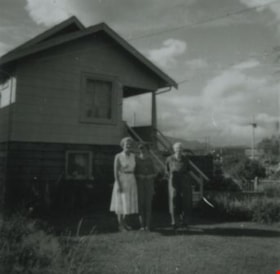
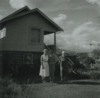
Ethel Derrick, Brenda Derrick and Agnes Beamish
https://search.heritageburnaby.ca/link/archivedescription37679
- Repository
- City of Burnaby Archives
- Date
- 1958 (date of original), copied 1991
- Collection/Fonds
- Burnaby Historical Society fonds
- Description Level
- Item
- Physical Description
- 1 photograph : b&w ; 3.7 x 3.7 cm print on contact sheet 20.2 x 25.3 cm
- Scope and Content
- Photograph of three generations; Ethel Beamish Derrick, her daughter Brenda Derrick and her mother Agnes Beamish, standing in front of the Beamish family home at 277 17th Avenue (later renumbered 8059 17th Avenue).
- Repository
- City of Burnaby Archives
- Date
- 1958 (date of original), copied 1991
- Collection/Fonds
- Burnaby Historical Society fonds
- Subseries
- Burnaby Image Bank subseries
- Physical Description
- 1 photograph : b&w ; 3.7 x 3.7 cm print on contact sheet 20.2 x 25.3 cm
- Description Level
- Item
- Record No.
- 370-267
- Access Restriction
- No restrictions
- Reproduction Restriction
- No restrictions
- Accession Number
- BHS1999-03
- Scope and Content
- Photograph of three generations; Ethel Beamish Derrick, her daughter Brenda Derrick and her mother Agnes Beamish, standing in front of the Beamish family home at 277 17th Avenue (later renumbered 8059 17th Avenue).
- Subjects
- Buildings - Residential - Houses
- Media Type
- Photograph
- Notes
- Title based on contents of photograph
- 1 b&w copy negative accompanying
- Geographic Access
- 17th Avenue
- Street Address
- 8059 17th Avenue
- Historic Neighbourhood
- East Burnaby (Historic Neighbourhood)
- Planning Study Area
- Second Street Area
Images
![Exterior view of Love farmhouse, [between 1966 and 1971] thumbnail](/media/hpo/_Data/_BVM_Images/2019/2019_0003_0001_001.jpg?width=280)
Exterior view of Love farmhouse
https://search.heritageburnaby.ca/link/museumdescription9915
- Repository
- Burnaby Village Museum
- Date
- [between 1966 and 1971]
- Collection/Fonds
- Love family fonds
- Description Level
- Item
- Physical Description
- 1 photograph : col. ; 10 x 15 cm print
- Scope and Content
- Photograph of the exterior of the Love farmhouse located at 7651 Cumberland Street (Address pre 1960: 1390 Cumberland Road) with trees and bushes in the front yard and the driveway to the right. This photograph was taken while Elsie Hughes (nee Love), her husband John Hughes and son Brent Hughes li…
- Repository
- Burnaby Village Museum
- Collection/Fonds
- Love family fonds
- Description Level
- Item
- Physical Description
- 1 photograph : col. ; 10 x 15 cm print
- Material Details
- Copy print was made from re-photographing an original colour slide
- Scope and Content
- Photograph of the exterior of the Love farmhouse located at 7651 Cumberland Street (Address pre 1960: 1390 Cumberland Road) with trees and bushes in the front yard and the driveway to the right. This photograph was taken while Elsie Hughes (nee Love), her husband John Hughes and son Brent Hughes lived in the house.
- History
- Elsie is the daughter of Sarah (nee Love) and William Parker. Sarah and William purchased the Love farmhouse in 1928, shortly after the death of Sarah's father, Jesse Love. Sarah and William Parker lived in the house with their three children, Albert, Bill and Elsie. William Parker died in 1961 and Sarah continued to live in the house until 1966 before selling it to her daughter Elsie and son in law John Hughes. Elsie and John lived in the house with their son Brent until 1971.
- Subjects
- Buildings - Heritage
- Geographic Access
- Cumberland Street
- Street Address
- 7651 Cumberland Street
- Accession Code
- BV019.3.1
- Access Restriction
- No restrictions
- Reproduction Restriction
- No known restrictions
- Date
- [between 1966 and 1971]
- Media Type
- Photograph
- Historic Neighbourhood
- East Burnaby (Historic Neighbourhood)
- Planning Study Area
- Cariboo-Armstrong Area
- Scan Resolution
- 300
- Scan Date
- 31-Jan-2019
- Scale
- 96
- Photographer
- Parker, Albert "Bert"
- Notes
- Title based on contents of photograph.
Images
![Exterior view of Love farmhouse, [between 1966 and 1971] thumbnail](/media/hpo/_Data/_BVM_Images/2019/2019_0003_0001_001.jpg)
![Exterior view of Love farmhouse, [between 1966 and 1970] thumbnail](/media/hpo/_Data/_BVM_Images/2019/2019_0003_0003_001.jpg?width=280)
Exterior view of Love farmhouse
https://search.heritageburnaby.ca/link/museumdescription9917
- Repository
- Burnaby Village Museum
- Date
- [between 1966 and 1970]
- Collection/Fonds
- Love family fonds
- Description Level
- Item
- Physical Description
- 1 photograph : col. ; 10 x 15 cm print
- Scope and Content
- Photograph of a side view of the exterior of the Love farmhouse located at 7651 Cumberland Street (Address pre 1960: 1390 Cumberland Road) with trees and bushes along the side of the house and a gravel driveway. In this side view of the house, you can see the kitchen addition and verandah. This pho…
- Repository
- Burnaby Village Museum
- Collection/Fonds
- Love family fonds
- Description Level
- Item
- Physical Description
- 1 photograph : col. ; 10 x 15 cm print
- Material Details
- Copy print was made from re-photographing an original colour slide
- Scope and Content
- Photograph of a side view of the exterior of the Love farmhouse located at 7651 Cumberland Street (Address pre 1960: 1390 Cumberland Road) with trees and bushes along the side of the house and a gravel driveway. In this side view of the house, you can see the kitchen addition and verandah. This photograph was taken while Elsie Hughes (nee Love), her husband John Hughes and son Brent Hughes lived in the house. Elsie is the daughter of Sarah (nee Love) and William Parker. Sarah and William purchased the house in 1928, shortly after the death of Sarah's father, Jesse Love. Sarah and William Parker lived in the house with their three children, Albert, Bill and Elsie. William Parker died in 1961 and Sarah continued to live in the house until 1966 before selling it to her daughter Elsie and son in law John Hughes. Elsie and John lived in the house with their son Brent until 1971.
- Subjects
- Buildings - Heritage
- Geographic Access
- Cumberland Street
- Street Address
- 7651 Cumberland Street
- Accession Code
- BV019.3.3
- Access Restriction
- No restrictions
- Reproduction Restriction
- No known restrictions
- Date
- [between 1966 and 1970]
- Media Type
- Photograph
- Historic Neighbourhood
- East Burnaby (Historic Neighbourhood)
- Planning Study Area
- Cariboo-Armstrong Area
- Scan Resolution
- 600
- Scan Date
- 31-Jan-2019
- Scale
- 96
- Photographer
- Parker, Albert "Bert"
- Notes
- Title based on contents of photograph
Images
![Exterior view of Love farmhouse, [between 1966 and 1970] thumbnail](/media/hpo/_Data/_BVM_Images/2019/2019_0003_0003_001.jpg)
![Exterior view of Love farmhouse, [between 1966 and 1970] thumbnail](/media/hpo/_Data/_BVM_Images/2019/2019_0003_0004_001.jpg?width=280)
Exterior view of Love farmhouse
https://search.heritageburnaby.ca/link/museumdescription9918
- Repository
- Burnaby Village Museum
- Date
- [between 1966 and 1970]
- Collection/Fonds
- Love family fonds
- Description Level
- Item
- Physical Description
- 1 photograph : col. ; 10 x 15 cm print
- Scope and Content
- Photograph of the south east side of the Love farmhouse located at 7651 Cumberland Street (Address pre 1960: 1390 Cumberland Road). Flowers grow on trellises against the verandah and a dog sits on the lawn alongside gardens, trees, wooden chairs and a picnic table. This photograph was taken while E…
- Repository
- Burnaby Village Museum
- Collection/Fonds
- Love family fonds
- Description Level
- Item
- Physical Description
- 1 photograph : col. ; 10 x 15 cm print
- Material Details
- Copy print was made from re-photographing an original colour slide
- Scope and Content
- Photograph of the south east side of the Love farmhouse located at 7651 Cumberland Street (Address pre 1960: 1390 Cumberland Road). Flowers grow on trellises against the verandah and a dog sits on the lawn alongside gardens, trees, wooden chairs and a picnic table. This photograph was taken while Elsie Hughes (nee Love), her husband John Hughes and son Brent Hughes lived in the house. Elsie is the daughter of Sarah (nee Love) and William Parker. Sarah and William purchased the house in 1928, shortly after the death of Sarah's father, Jesse Love. Sarah and William Parker lived in the house with their three children, Albert, Bill and Elsie. William Parker died in 1961 and Sarah continued to live in the house until 1966 before selling it to her daughter Elsie and son in law John Hughes. Elsie and John lived in the house with their son Brent until 1971.
- Subjects
- Buildings - Heritage
- Geographic Access
- Cumberland Street
- Street Address
- 7651 Cumberland Street
- Accession Code
- BV019.3.4
- Access Restriction
- No restrictions
- Reproduction Restriction
- No known restrictions
- Date
- [between 1966 and 1970]
- Media Type
- Photograph
- Historic Neighbourhood
- East Burnaby (Historic Neighbourhood)
- Planning Study Area
- Cariboo-Armstrong Area
- Scan Resolution
- 600
- Scan Date
- 31-Jan-2019
- Scale
- 96
- Photographer
- Parker, Albert "Bert"
- Notes
- Title based on contents of photograph
Images
![Exterior view of Love farmhouse, [between 1966 and 1970] thumbnail](/media/hpo/_Data/_BVM_Images/2019/2019_0003_0004_001.jpg)
![Exterior view of Love farmhouse, [between 1966 and 1970] thumbnail](/media/hpo/_Data/_BVM_Images/2019/2019_0003_0011_001.jpg?width=280)
Exterior view of Love farmhouse
https://search.heritageburnaby.ca/link/museumdescription9921
- Repository
- Burnaby Village Museum
- Date
- [between 1966 and 1970]
- Collection/Fonds
- Love family fonds
- Description Level
- Item
- Physical Description
- 1 photograph : col. ; 10 x 15 cm print
- Scope and Content
- Photograph of the south east side of the Love farmhouse located at 7651 Cumberland Street (Address pre 1960: 1390 Cumberland Road). Flowers are growing on trellises against the pillars of the verandah and there are two wooden lawn chairs and a picnic table on the lawn under a large tree. This photo…
- Repository
- Burnaby Village Museum
- Collection/Fonds
- Love family fonds
- Description Level
- Item
- Physical Description
- 1 photograph : col. ; 10 x 15 cm print
- Material Details
- Copy print was made from re-photographing an original colour slide
- Scope and Content
- Photograph of the south east side of the Love farmhouse located at 7651 Cumberland Street (Address pre 1960: 1390 Cumberland Road). Flowers are growing on trellises against the pillars of the verandah and there are two wooden lawn chairs and a picnic table on the lawn under a large tree. This photograph was taken while Elsie Hughes (nee Love), her husband John Hughes and son Brent Hughes lived in the house. Elsie is the daughter of Sarah (nee Love) and William Parker. Sarah and William purchased the house in 1928, shortly after the death of Sarah's father, Jesse Love. Sarah and William Parker lived in the house with their three children, Albert, Bill and Elsie. William Parker died in 1961 and Sarah continued to live in the house until 1966 before selling it to her daughter Elsie and son in law John Hughes. Elsie and John lived in the house with their son Brent until 1971.
- Subjects
- Buildings - Heritage
- Geographic Access
- Cumberland Street
- Street Address
- 7651 Cumberland Street
- Accession Code
- BV019.3.11
- Access Restriction
- No restrictions
- Reproduction Restriction
- No known restrictions
- Date
- [between 1966 and 1970]
- Media Type
- Photograph
- Historic Neighbourhood
- East Burnaby (Historic Neighbourhood)
- Planning Study Area
- Cariboo-Armstrong Area
- Scan Resolution
- 600
- Scan Date
- 31-Jan-2019
- Scale
- 96
- Photographer
- Parker, Albert "Bert"
- Notes
- Title based on contents of photograph
Images
![Exterior view of Love farmhouse, [between 1966 and 1970] thumbnail](/media/hpo/_Data/_BVM_Images/2019/2019_0003_0011_001.jpg)