Narrow Results By
Decade
- 2020s 11
- 2010s 5
- 2000s 106
- 1990s 88
- 1980s 22
- 1970s 305
- 1960s
- 1950s 82
- 1940s 60
- 1930s 53
- 1920s
- 1910s 65
- 1900s
- 1890s 10
- 1880s 2
- 1870s 1
- 1860s 2
- 1850s 1
- 1840s 1
- 1830s 1
- 1820s 1
- 1810s 1
- 1800s 1
- 1790s 1
- 1780s 1
- 1770s 1
- 1760s 1
- 1750s 1
- 1740s 1
- 1730s 1
- 1720s 1
- 1710s 1
- 1700s 1
- 1690s 1
- 1680s 1
- 1670s 1
- 1660s 1
- 1650s 1
- 1640s 1
- 1630s 1
- 1620s 1
- 1610s 1
- 1600s 1

British Columbia Institute of Technology (BCIT)
https://search.heritageburnaby.ca/link/landmark806
- Repository
- Burnaby Heritage Planning
- Geographic Access
- Willingdon Avenue
- Associated Dates
- 1960
- Heritage Value
- The BC Vocational School was established in 1960 at Willingdon and Canada Way. By 1964, the British Columbia Insitute of Technology had opened and had 498 students enrolled. In the 1970s, the BC Vocational School had been renamed the Pacific Vocational Institute and in 1986 the two institutions merged. The school is a public post-secondary institution that is governed by a Board of Governors, under the authority of the Ministry of Advanced Education, Training and Technology. By 2004, the annual enrolment of part-time and full-time students reached 48,000.
- Planning Study Area
- Douglas-Gilpin Area
- Street Address
- 3700 Willingdon Avenue
- Street View URL
- Google Maps Street View
Images


Douglas-Gilpin Neighbourhood
https://search.heritageburnaby.ca/link/landmark799
- Repository
- Burnaby Heritage Planning
- Associated Dates
- 1955-2008
- Heritage Value
- The Douglas-Gilpin Neighbourhood developed into a diverse area incorporating residential, business, educational and park districts in the period after 1955. The BCIT site was built in the early 1960s, shortly after the Burnaby Municipal Hall was located on Canada Way near Deer Lake in 1956. The construction of the Municipal Hall at this location fostered the creation of an administrative and business centre adjacent to the park, while the northern and central areas of the neighbourhood retained their primarily residential character.
- Historic Neighbourhood
- Burnaby Lake (Historic Neighbourhood)
- Planning Study Area
- Douglas-Gilpin Area
Images


Douglas Road School
https://search.heritageburnaby.ca/link/landmark573
- Repository
- Burnaby Heritage Planning
- Description
- School building.
- Associated Dates
- 1928
- Other Names
- Douglas Road Elementary School
- Street View URL
- Google Maps Street View
- Repository
- Burnaby Heritage Planning
- Other Names
- Douglas Road Elementary School
- Geographic Access
- Canada Way
- Associated Dates
- 1928
- Description
- School building.
- Heritage Value
- The Douglas Road School was originally established as a two-room school in 1908 on this site, and later expanded to four classrooms. Anticipating rapid settlement of this district, the School Board purchased two acres adjoining the old building. Two of the four rooms were designed to become one large auditorium suitable for special events and public gatherings, with seating for two hundred people. The classically-influenced school has been altered with new windows and extended with additional wings, but has retained its original red-brick veneer, tan-brick quoins and bellcast octagonal roof ventilator. Designed by McCarter & Nairne, the school was built by contractor A.S. Perry. McCarter & Nairne, who also designed the Second Street School, were the Burnaby School Board architects at this time. John Y. McCarter (1886-1981) and George Nairne (1884-1953) formed their partnership in 1921 after serving overseas during the First World War. The partners began designing houses and small apartment buildings, and their commissions included Vancouver’s first skyscraper, the Marine Building (1928-30).
- Locality
- Burnaby Lake
- Historic Neighbourhood
- Burnaby Lake (Historic Neighbourhood)
- Planning Study Area
- Douglas-Gilpin Area
- Architect
- McCarter & Nairne
- Subjects
- Buildings - Heritage
- Buildings - Schools
- Street Address
- 4861 Canada Way
- Street View URL
- Google Maps Street View
Images


Douglas Road School
https://search.heritageburnaby.ca/link/landmark754
- Repository
- Burnaby Heritage Planning
- Geographic Access
- Canada Way
- Associated Dates
- 1908
- Heritage Value
- This school was the fifth to open in Burnaby and was initially known as Lake View School. In 1913, names of Burnaby Schools were changed to reflect their location and thus Lake View became Douglas Road. The first building on the site was torn down in the 1950s but the main building, which was constructed in 1928, remains although it had additions and renovations done in 1950, 1954, 1960, 1961, 1967 and 1973.
- Historic Neighbourhood
- Burnaby Lake (Historic Neighbourhood)
- Planning Study Area
- Douglas-Gilpin Area
- Street Address
- 4861 Canada Way
- Street View URL
- Google Maps Street View
Images


Frederick & Edna Cunningham House
https://search.heritageburnaby.ca/link/landmark522
- Repository
- Burnaby Heritage Planning
- Description
- Set back from Douglas Road, the Frederick and Edna Cunningham House is a picturesque wood-frame one and one-half storey British Arts and Crafts-style residence, clad with rough-cast stucco and featuring half-timbering in the gable ends. Set far back on a large east-sloping site in a mature landscap…
- Associated Dates
- 1923
- Formal Recognition
- Heritage Designation, Community Heritage Register
- Street View URL
- Google Maps Street View
- Repository
- Burnaby Heritage Planning
- Geographic Access
- Douglas Road
- Associated Dates
- 1923
- Formal Recognition
- Heritage Designation, Community Heritage Register
- Enactment Type
- Bylaw No. 10470
- Enactment Date
- 04/11/1996
- Description
- Set back from Douglas Road, the Frederick and Edna Cunningham House is a picturesque wood-frame one and one-half storey British Arts and Crafts-style residence, clad with rough-cast stucco and featuring half-timbering in the gable ends. Set far back on a large east-sloping site in a mature landscape setting, it is located in the Douglas Road neighbourhood located in the central valley of Burnaby.
- Heritage Value
- Considered a landmark in the Douglas Road neighbourhood, the Cunningham House is valued as a good example of a British Arts and Crafts-style residence. The house blends into its surroundings, which are extensively landscaped with rockeries, lawns, shrubs, trees and perennial beds. The two majestic copper beech trees, over 60 years old, are among the best specimens of their type to be found in Greater Vancouver and are protected under covenant. The Cunningham property is significant as one of the last estate homes remaining on the old Douglas Road, at one time noted for its beautiful estates set within the rural character of Burnaby’s Central Valley. Insurance agent Frederick Woodman Cunningham (1882-1963) and his wife, Edna Elizabeth Cunningham (1884-1982), built this country residence in 1923. Fred was the only son of James Cunningham, a pioneer of New Westminster who arrived in 1862 and served as the City’s Mayor from 1872 to 1874. The landmark flagpole that once stood in the garden was moved to this site when Fred Cunningham's prestigious family home in New Westminster at Third Avenue and Seventh Street was demolished in 1938. Kept within the family until 1982 and largely maintained in its original condition, the Cunningham House is an excellent example of one of Burnaby's best estate homes from the 1920s and was designated by the City of Burnaby in 1996.
- Defining Elements
- Key elements that define the heritage character of the Cunningham House include its: - location on Douglas Road, in Burnaby’s Central Valley - views from the property to the east and towards the North Shore - residential form, scale and massing as exemplified by its one and one-half storey height and rectangular plan - side gabled roof with front gabled dormer and cedar shingle cladding - British Arts and Crafts elements such as its rough-cast stucco, tapered porch columns, large eave brackets, exposed purlins and half-timbering - irregular fenestration including double-hung 1-over-1 wooden-sash windows, multi-pane wooden-sash casement windows and multiple-assembly windows in the gable ends - front entrance porch with shed roof - two internal red brick chimneys - early cedar-shingled garage at side of house - associated landscape features, including two landmark Copper beech trees and landscaped rockeries at the front of the property
- Historic Neighbourhood
- Burnaby Lake (Historic Neighbourhood)
- Planning Study Area
- Douglas-Gilpin Area
- Function
- Primary Historic--Single Dwelling
- Primary Current--Single Dwelling
- Community
- Burnaby
- Cadastral Identifier
- 003-118-746
- Boundaries
- The Cunningham House is comprised of a single residential lot located at 3555 Douglas Road, Burnaby.
- Area
- 4446.5
- Contributing Resource
- Building
- Ownership
- Private
- Street Address
- 3555 Douglas Road
- Street View URL
- Google Maps Street View
Images


Gilpin Elementary School
https://search.heritageburnaby.ca/link/landmark811
- Repository
- Burnaby Heritage Planning
- Geographic Access
- Eglinton Street
- Associated Dates
- 1966
- Heritage Value
- Gilpin Elementary School was built to serve a new housing development extending out from the Douglas Road school area towards the Oakalla Prison site and the Forest Lawn Cemetery. Built in 1966, the school, like other elementary schools of the era, was one-storey, without basement or high stairs. Additions to the building were made in 1969 and 1973.
- Historic Neighbourhood
- Burnaby Lake (Historic Neighbourhood)
- Planning Study Area
- Douglas-Gilpin Area
- Street Address
- 5490 Eglinton Street
- Street View URL
- Google Maps Street View
Images


H.T. Ceperley Estate 'Fairacres' Greenhouse Foundation Wall
https://search.heritageburnaby.ca/link/landmark862
- Repository
- Burnaby Heritage Planning
- Description
- The original rubble stone walls that formed the foundation for a greenhouses adjacent to the Steam Plant Building provided heat to several greenhouses on the estate propoerty. The Root House, which is to the north of the Greenhouse Foundation Wall, provided storage for the farm operation.
- Associated Dates
- 1908
- Formal Recognition
- Heritage Designation, Community Heritage Register
- Repository
- Burnaby Heritage Planning
- Geographic Access
- Deer Lake Avenue
- Associated Dates
- 1908
- Formal Recognition
- Heritage Designation, Community Heritage Register
- Enactment Type
- Bylaw No. 140665
- Enactment Date
- 23/11/1992
- Description
- The original rubble stone walls that formed the foundation for a greenhouses adjacent to the Steam Plant Building provided heat to several greenhouses on the estate propoerty. The Root House, which is to the north of the Greenhouse Foundation Wall, provided storage for the farm operation.
- Heritage Value
- The outbuildings at 'Fairacres' are a rare surviving architecturally-designed ensemble of agricultural structures that exist in complementary harmony with the main estate house. Architect Robert Mackay Fripp (1858-1917), an outspoken advocate of Arts and Crafts design, was retained by the Ceperleys to design several original outbuildings on their estate, which was designed as a country estate with a working farm that included over 10 acres of productive berry and vegetable fields, with a large kitchen garden, a root house to store food, an orchard, and greenhouses heated by steam. The agricultural potential of the Deer Lake area made it one of the first parts of the municipality to attract settlement. In 1909, the Ceperleys built three large greenhouses heated by an adjacent steam plant (Fairacres Steam Plant). The greenhouses featured granite foundation walls, including this one which remains intact. The Ceperleys employed a large staff to manage the estate's agricultural production, including Chinese farm labourers. Produce was grown for use at the estate, and for sale at local markets. Agricultural use of the estate continued when a Catholic order of Benedictine monks purchased the estate as part of the Priory of St. Joseph and the Seminary of Christ the King, and continued to farm the land until 1953.
- Defining Elements
- Key elements that define the heritage character of the ‘Fairacres’ Steam Plant Building include its: - overall spatial arrangement of the Greenhouse Foundation Wall in relation to the Steam Plant Building and the Root House - original rubble stone walls reflecting the Arts and Crafts design aesthetic of the estate buildings.
- Locality
- Deer Lake Park
- Historic Neighbourhood
- Burnaby Lake (Historic Neighbourhood)
- Planning Study Area
- Douglas-Gilpin Area
- Architect
- Robert Mackay Fripp
- Function
- Primary Historic--Outbuilding
- Community
- Burnaby
- Cadastral Identifier
- P.I.D. No. 004-493-311 Legal Description: Block 3 Except: Part subdivided by Plan 26865, District Lot 79, Group 1, New Westminster District, Plan 536
- Boundaries
- ‘Fairacres’ is comprised of a single municipally-owned property located at 6344 Deer Lake Avenue, Burnaby.
- Area
- 17,065.00
- Contributing Resource
- Landscape Feature
- Remains
- Ownership
- Public (local)
- Other Collection
- Burnaby Historical Society, Community Archives: Ceperley Photograph Album
- Documentation
- Heritage Site Files: PC77000 20. City of Burnaby Planning and Building Department, 4949 Canada Way, Burnaby, B.C., V5G 1M2
- Street Address
- 6344 Deer Lake Avenue
Images


H.T. Ceperley Estate 'Fairacres' Root House
https://search.heritageburnaby.ca/link/landmark527
- Repository
- Burnaby Heritage Planning
- Description
- The ‘Fairacres’ Root House is a long, low one-storey masonry building, measuring 4.6 metres by 9.1 metres, with massively buttressed concrete walls and foundations. Built into sloping ground adjacent to the location of the former greenhouses, the surviving orchard and the kitchen entrance of the ma…
- Associated Dates
- 1908
- Formal Recognition
- Heritage Designation, Community Heritage Register
- Repository
- Burnaby Heritage Planning
- Geographic Access
- Deer Lake Avenue
- Associated Dates
- 1908
- Formal Recognition
- Heritage Designation, Community Heritage Register
- Enactment Type
- Bylaw No. 9807
- Enactment Date
- 23/11/1992
- Description
- The ‘Fairacres’ Root House is a long, low one-storey masonry building, measuring 4.6 metres by 9.1 metres, with massively buttressed concrete walls and foundations. Built into sloping ground adjacent to the location of the former greenhouses, the surviving orchard and the kitchen entrance of the main house, 'Fairacres,' this functional structure was used as a frost-free store for fruit and vegetables for the family's use.
- Heritage Value
- The outbuildings at 'Fairacres' are a rare surviving architecturally-designed ensemble of agricultural structures that exist in complementary harmony with the main estate house. Architect Robert Mackay Fripp (1858-1917), an outspoken advocate of Arts and Crafts design, was retained by the Ceperleys to design several original outbuildings on their estate. The Root House is important as a rare surviving, and exceptionally large, example of this building type in the Vancouver region. Unusual in the fact that an architect designed a building of such modest aspirations, it is also remarkable in its method of construction. The use of concrete as a structural material is one of the earliest in the region and extraordinary for its use on such a modest vernacular outbuilding; root cellars were typically built of loose stone. Built in 1908, the Root House was significantly altered in the 1960s and restored to its original design in 2000. The building is significant as an indicator of the market gardening activity in the area around Deer Lake and of the country-house self-sufficiency practiced by the Ceperley family. The Root House illustrates the cultural, aesthetic, and lifestyle values of the Ceperleys in constructing such a large building for storing their own produce.
- Defining Elements
- The outbuildings at 'Fairacres' are a rare surviving architecturally-designed ensemble of agricultural structures that exist in complementary harmony with the main estate house. Architect Robert Mackay Fripp (1858-1917), an outspoken advocate of Arts and Crafts design, was retained by the Ceperleys to design several original outbuildings on their estate. The Root House is important as a rare surviving, and exceptionally large, example of this building type in the Vancouver region. Unusual in the fact that an architect designed a building of such modest aspirations, it is also remarkable in its method of construction. The use of concrete as a structural material is one of the earliest in the region and extraordinary for its use on such a modest vernacular outbuilding; root cellars were typically built of loose stone. Built in 1908, the Root House was significantly altered in the 1960s and restored to its original design in 2000. The building is significant as an indicator of the market gardening activity in the area around Deer Lake and of the country-house self-sufficiency practiced by the Ceperley family. The Root House illustrates the cultural, aesthetic, and lifestyle values of the Ceperleys in constructing such a large building for storing their own produce.
- Locality
- Deer Lake Park
- Historic Neighbourhood
- Burnaby Lake (Historic Neighbourhood)
- Planning Study Area
- Douglas-Gilpin Area
- Architect
- Robert Mackay Fripp
- Function
- Primary Historic--Outbuilding
- Secondary Historic--Food Storage
- Community
- Burnaby
- Cadastral Identifier
- P.I.D. No. 004-493-311 Legal Description: Block 3 Except: Part subdivided by Plan 26865, District Lot 79, Group 1, New Westminster District, Plan 536
- Boundaries
- ‘Fairacres’ is comprised of a single municipally-owned property located at 6344 Deer Lake Avenue, Burnaby.
- Area
- 17,065.00
- Contributing Resource
- Building
- Landscape Feature
- Ownership
- Public (local)
- Other Collection
- Burnaby Historical Society, Community Archives: Ceperley Photograph Album
- Documentation
- Heritage Site Files: PC77000 20. City of Burnaby Planning and Building Department, 4949 Canada Way, Burnaby, B.C., V5G 1M2
- Street Address
- 6344 Deer Lake Avenue
Images


H.T. Ceperley Estate 'Fairacres' Steam Plant Building
https://search.heritageburnaby.ca/link/landmark528
- Repository
- Burnaby Heritage Planning
- Description
- Designed in the British Arts and Crafts style, the ‘Fairacres’ Steam Plant Buiding is a single-storey wood frame building with a gabled roof that originally housed the apparatus for climate control in the greenhouses, formerly located to its north. The original rubble stone walls that formed the fo…
- Associated Dates
- 1908
- Formal Recognition
- Heritage Designation, Community Heritage Register
- Repository
- Burnaby Heritage Planning
- Geographic Access
- Deer Lake Avenue
- Associated Dates
- 1908
- Formal Recognition
- Heritage Designation, Community Heritage Register
- Enactment Type
- Bylaw No. 9807
- Enactment Date
- 23/11/1992
- Description
- Designed in the British Arts and Crafts style, the ‘Fairacres’ Steam Plant Buiding is a single-storey wood frame building with a gabled roof that originally housed the apparatus for climate control in the greenhouses, formerly located to its north. The original rubble stone walls that formed the foundation for the greenhouses stand adjacent. The Steam Plant Building stands as a pendant to the Root House, which is to the north of the former greenhouses.
- Heritage Value
- The outbuildings at 'Fairacres' are a rare surviving architecturally-designed ensemble of agricultural structures that exist in complementary harmony with the main estate house. Architect Robert Mackay Fripp (1858-1917), an outspoken advocate of Arts and Crafts design, was retained by the Ceperleys to design several original outbuildings on their estate. The Ceperleys operated 'Fairacres' with staff, a farm manager and workers, including Chinese, to grow produce for themselves and for sale at local markets. The Steam Plant Building illustrates the market gardening activity of the area around Deer Lake and its importance to the Ceperley family, which valued a year-round supply of fresh fruit and vegetables for the kitchen and flowers for the house. It also illustrates the cultural and aesthetic values of the Ceperleys in retaining an architect to design a functional outbuilding using an accepted and contemporary architectural style. Built in 1908, the Steam Plant Building was significantly altered in the 1960s and restored to its original design in 2000.
- Defining Elements
- Key elements that define the heritage character of the ‘Fairacres’ Steam Plant Building include its: - overall spatial arrangement of the Steam Plant Building in relation to the former greenhouses and the Root House - side gable roof with cedar shingle cladding. - tall brick chimney indicitive of the building's original function. - distinctive Arts and Crafts architectural features such as the shingle wall cladding with decorative shingling under window sills, deep eaves, and pebble-dashed concrete foundation walls - six-paned wooden-sash casement windows - simple functional interior features - rubble stone walls that formed the foundation for the greenhouses
- Locality
- Deer Lake Park
- Historic Neighbourhood
- Burnaby Lake (Historic Neighbourhood)
- Planning Study Area
- Douglas-Gilpin Area
- Architect
- Robert Mackay Fripp
- Function
- Primary Historic--Outbuilding
- Community
- Burnaby
- Cadastral Identifier
- P.I.D. No. 004-493-311 Legal Description: Block 3 Except: Part subdivided by Plan 26865, District Lot 79, Group 1, New Westminster District, Plan 536
- Boundaries
- ‘Fairacres’ is comprised of a single municipally-owned property located at 6344 Deer Lake Avenue, Burnaby.
- Area
- 17,065.00
- Contributing Resource
- Building
- Landscape Feature
- Ownership
- Public (local)
- Other Collection
- Burnaby Historical Society, Community Archives: Ceperley Photograph Album
- Documentation
- Heritage Site Files: PC77000 20. City of Burnaby Planning and Building Department, 4949 Canada Way, Burnaby, B.C., V5G 1M2
- Street Address
- 6344 Deer Lake Avenue
Images


William & Edith Blott Residence
https://search.heritageburnaby.ca/link/landmark655
- Repository
- Burnaby Heritage Planning
- Description
- Residential building.
- Associated Dates
- 1923
- Street View URL
- Google Maps Street View
- Repository
- Burnaby Heritage Planning
- Geographic Access
- Laurel Street
- Associated Dates
- 1923
- Description
- Residential building.
- Heritage Value
- This elegant house is a prominent local landmark, with a bellcast hipped roof, deep bracketed eaves and Doric porch columns. The use of the various Colonial Revival styles had gained new popularity during the 1920s at the time of the American Sesquicentennial, as is evident in the symmetrical façade composition and detailing. It was the home of William Alexander Blott (1878-1962), a shipper at the Broder Canning Company and later a real estate agent, and his wife Edith Carruthers Blott (née Shaw, 1890-1972), who were married in 1913. It is one of the few remaining larger estate homes along the formerly rural Douglas Road.
- Locality
- Burnaby Lake
- Historic Neighbourhood
- Burnaby Lake (Historic Neighbourhood)
- Planning Study Area
- Douglas-Gilpin Area
- Area
- 1023.73
- Contributing Resource
- Building
- Ownership
- Private
- Street Address
- 5558 Laurel Street
- Street View URL
- Google Maps Street View
Images

![4006 Douglas Road, [1960] (date of original), copied 1991 thumbnail](/media/hpo/_Data/_Archives_Images/_Unrestricted/370/370-516.jpg?width=280)
4006 Douglas Road
https://search.heritageburnaby.ca/link/archivedescription37928
- Repository
- City of Burnaby Archives
- Date
- [1960] (date of original), copied 1991
- Collection/Fonds
- Burnaby Historical Society fonds
- Description Level
- Item
- Physical Description
- 1 photograph : b&w ; 3.1 x 3.1 cm print on contact sheet 20.7 x 26.5 cm
- Scope and Content
- Photograph of 4006 Douglas Road (old numbering) in the snow. The house was located near Douglas Road and Gilpin Street.
- Repository
- City of Burnaby Archives
- Date
- [1960] (date of original), copied 1991
- Collection/Fonds
- Burnaby Historical Society fonds
- Subseries
- Burnaby Image Bank subseries
- Physical Description
- 1 photograph : b&w ; 3.1 x 3.1 cm print on contact sheet 20.7 x 26.5 cm
- Description Level
- Item
- Record No.
- 370-516
- Access Restriction
- No restrictions
- Reproduction Restriction
- No restrictions
- Accession Number
- BHS1999-03
- Scope and Content
- Photograph of 4006 Douglas Road (old numbering) in the snow. The house was located near Douglas Road and Gilpin Street.
- Subjects
- Natural Phenomena - Snow
- Media Type
- Photograph
- Notes
- Title based on contents of photograph
- 1 b&w copy negative accompanying
- Negative has a pink cast
- Geographic Access
- Gilpin Street
- Historic Neighbourhood
- Burnaby Lake (Historic Neighbourhood)
- Planning Study Area
- Douglas-Gilpin Area
Images
![4006 Douglas Road, [1960] (date of original), copied 1991 thumbnail](/media/hpo/_Data/_Archives_Images/_Unrestricted/370/370-516.jpg)
Aerial photograph of Burnaby
https://search.heritageburnaby.ca/link/archivedescription84903
- Repository
- City of Burnaby Archives
- Date
- 1963
- Collection/Fonds
- Allan Amundsen collection
- Description Level
- Item
- Physical Description
- 1 photograph : b&w ; 22.5 x 22.5 cm
- Scope and Content
- Aerial photograph of Burnaby with the Trans Canada Highway running through and the Forest Lawn Cemetery to the south.
- Repository
- City of Burnaby Archives
- Date
- 1963
- Collection/Fonds
- Allan Amundsen collection
- Physical Description
- 1 photograph : b&w ; 22.5 x 22.5 cm
- Description Level
- Item
- Record No.
- 561-024
- Access Restriction
- In Archives only
- Reproduction Restriction
- No reproduction permitted
- Accession Number
- 2014-08
- Scope and Content
- Aerial photograph of Burnaby with the Trans Canada Highway running through and the Forest Lawn Cemetery to the south.
- Subjects
- Aerial Photographs
- Media Type
- Photograph
- Photographer
- Province of British Columbia
- Notes
- Title based on contents of photograph
- This photo is indentified as BC5062:27 and connects with B.C. air photograph BC5061:26 to the east
- Historic Neighbourhood
- Burnaby Lake (Historic Neighbourhood)
- Planning Study Area
- Douglas-Gilpin Area
- Ardingley-Sprott Area
- Dawson-Delta Area
Aerial photograph of Burnaby
https://search.heritageburnaby.ca/link/archivedescription84907
- Repository
- City of Burnaby Archives
- Date
- 1963
- Collection/Fonds
- Allan Amundsen collection
- Description Level
- Item
- Physical Description
- 1 photograph : b&w ; 22.5 x 22.5 cm
- Scope and Content
- Aerial photograph of Burnaby with the Trans Canada Highway running from through and Burnaby Lake in the south east corner.
- Repository
- City of Burnaby Archives
- Date
- 1963
- Collection/Fonds
- Allan Amundsen collection
- Physical Description
- 1 photograph : b&w ; 22.5 x 22.5 cm
- Description Level
- Item
- Record No.
- 561-025
- Access Restriction
- In Archives only
- Reproduction Restriction
- No reproduction permitted
- Accession Number
- 2014-08
- Scope and Content
- Aerial photograph of Burnaby with the Trans Canada Highway running from through and Burnaby Lake in the south east corner.
- Subjects
- Aerial Photographs
- Media Type
- Photograph
- Photographer
- Province of British Columbia
- Notes
- Title based on contents of photograph
- This photo is indentified as BC5062:26 and connects with B.C. air photograph BC5062:27 to the west and B.C. air photograph BC5062:25 to the east
- Historic Neighbourhood
- Burnaby Lake (Historic Neighbourhood)
- Planning Study Area
- Douglas-Gilpin Area
- Ardingley-Sprott Area
- Burnaby Lake Area
Aerial photograph of Burnaby Lake Area
https://search.heritageburnaby.ca/link/archivedescription84908
- Repository
- City of Burnaby Archives
- Date
- 1963
- Collection/Fonds
- Allan Amundsen collection
- Description Level
- Item
- Physical Description
- 1 photograph : b&w ; 22.5 x 22.5 cm
- Scope and Content
- Aerial photograph of Burnaby with Lougheed Highway in the north west corner, the Trans Canada Highway in the south east corner and Burnaby Lake appearing from the west.
- Repository
- City of Burnaby Archives
- Date
- 1963
- Collection/Fonds
- Allan Amundsen collection
- Physical Description
- 1 photograph : b&w ; 22.5 x 22.5 cm
- Description Level
- Item
- Record No.
- 561-026
- Access Restriction
- In Archives only
- Reproduction Restriction
- No reproduction permitted
- Accession Number
- 2014-08
- Scope and Content
- Aerial photograph of Burnaby with Lougheed Highway in the north west corner, the Trans Canada Highway in the south east corner and Burnaby Lake appearing from the west.
- Subjects
- Aerial Photographs
- Media Type
- Photograph
- Photographer
- Province of British Columbia
- Notes
- Title based on contents of photograph
- This photo is indentified as BC5062:25 and connects with B.C. air photograph BC5062:26 to the west and B.C. air photograph BC5062:24 to the east
- Historic Neighbourhood
- Burnaby Lake (Historic Neighbourhood)
- Lozells (Historic Neighbourhood)
- Planning Study Area
- Douglas-Gilpin Area
- Sperling-Broadway Area
- Government Road Area
- Burnaby Lake Area
Aerial photograph of Burnaby Lake Area
https://search.heritageburnaby.ca/link/archivedescription84909
- Repository
- City of Burnaby Archives
- Date
- 1963
- Collection/Fonds
- Allan Amundsen collection
- Description Level
- Item
- Physical Description
- 1 photograph : b&w ; 22.5 x 22.5 cm
- Scope and Content
- Aerial photograph of Burnaby with Lougheed Highway to the north and Burnaby Lake to the south.
- Repository
- City of Burnaby Archives
- Date
- 1963
- Collection/Fonds
- Allan Amundsen collection
- Physical Description
- 1 photograph : b&w ; 22.5 x 22.5 cm
- Description Level
- Item
- Record No.
- 561-027
- Access Restriction
- In Archives only
- Reproduction Restriction
- No reproduction permitted
- Accession Number
- 2014-08
- Scope and Content
- Aerial photograph of Burnaby with Lougheed Highway to the north and Burnaby Lake to the south.
- Subjects
- Aerial Photographs
- Media Type
- Photograph
- Photographer
- Province of British Columbia
- Notes
- Title based on contents of photograph
- This photo is indentified as BC5062:24 and connects with B.C. air photograph BC5062:25 to the west and B.C. air photograph BC5062:23 to the east
- Historic Neighbourhood
- Burnaby Lake (Historic Neighbourhood)
- Lozells (Historic Neighbourhood)
- Planning Study Area
- Douglas-Gilpin Area
- Sperling-Broadway Area
- Government Road Area
- Burnaby Lake Area
![Albert and Elsie Dawkins, [1923] (date of original), copied 1991 thumbnail](/media/hpo/_Data/_Archives_Images/_Unrestricted/370/370-276.jpg?width=280)
Albert and Elsie Dawkins
https://search.heritageburnaby.ca/link/archivedescription37688
- Repository
- City of Burnaby Archives
- Date
- [1923] (date of original), copied 1991
- Collection/Fonds
- Burnaby Historical Society fonds
- Description Level
- Item
- Physical Description
- 1 photograph : b&w ; 2.9 x 5.0 cm print on contact sheet 20.2 x 25.3 cm
- Scope and Content
- Photograph of siblings Albert Dawkins (age 9) and Elsie Dawkins (age 5) at their Balfour Avenue home (later renamed Atlee Avenue). Albert is holding a cat, and Elsie is standing beside a dog.
- Repository
- City of Burnaby Archives
- Date
- [1923] (date of original), copied 1991
- Collection/Fonds
- Burnaby Historical Society fonds
- Subseries
- Burnaby Image Bank subseries
- Physical Description
- 1 photograph : b&w ; 2.9 x 5.0 cm print on contact sheet 20.2 x 25.3 cm
- Description Level
- Item
- Record No.
- 370-276
- Access Restriction
- No restrictions
- Reproduction Restriction
- No known restrictions
- Accession Number
- BHS1999-03
- Scope and Content
- Photograph of siblings Albert Dawkins (age 9) and Elsie Dawkins (age 5) at their Balfour Avenue home (later renamed Atlee Avenue). Albert is holding a cat, and Elsie is standing beside a dog.
- Subjects
- Animals - Cats
- Animals - Dogs
- Media Type
- Photograph
- Notes
- Title based on contents of photograph
- 1 b&w copy negative accompanying
- Negative has a pink cast
- Geographic Access
- Atlee Avenue
- Historic Neighbourhood
- Burnaby Lake (Historic Neighbourhood)
- Planning Study Area
- Douglas-Gilpin Area
Images
![Albert and Elsie Dawkins, [1923] (date of original), copied 1991 thumbnail](/media/hpo/_Data/_Archives_Images/_Unrestricted/370/370-276.jpg)

Anderson family
https://search.heritageburnaby.ca/link/archivedescription37447
- Repository
- City of Burnaby Archives
- Date
- 1961 (date of original), copied 1991
- Collection/Fonds
- Burnaby Historical Society fonds
- Description Level
- Item
- Physical Description
- 1 photograph : b&w ; 4.1 x 3.5 cm print on contact sheet 20.2 x 25.4 cm
- Scope and Content
- Photograph of the Anderson family at the back of their home at 3908 Norland Avenue (previously numbered 4437 Norland Avenue). Left to right: Cliff Anderson (son), Janet Anderson (daughter), and Robert "Bob" Anderson (father). The background includes the area of the Trans Canada Highway before it w…
- Repository
- City of Burnaby Archives
- Date
- 1961 (date of original), copied 1991
- Collection/Fonds
- Burnaby Historical Society fonds
- Subseries
- Burnaby Image Bank subseries
- Physical Description
- 1 photograph : b&w ; 4.1 x 3.5 cm print on contact sheet 20.2 x 25.4 cm
- Description Level
- Item
- Record No.
- 370-035
- Access Restriction
- No restrictions
- Reproduction Restriction
- No restrictions
- Accession Number
- BHS1999-03
- Scope and Content
- Photograph of the Anderson family at the back of their home at 3908 Norland Avenue (previously numbered 4437 Norland Avenue). Left to right: Cliff Anderson (son), Janet Anderson (daughter), and Robert "Bob" Anderson (father). The background includes the area of the Trans Canada Highway before it was built.
- Media Type
- Photograph
- Notes
- Title based on contents of photograph
- 1 b&w copy negative accompanying
- Geographic Access
- Norland Avenue
- Street Address
- 3908 Norland Avenue
- Historic Neighbourhood
- Burnaby Lake (Historic Neighbourhood)
- Planning Study Area
- Douglas-Gilpin Area
Images


Anderson family home
https://search.heritageburnaby.ca/link/archivedescription37448
- Repository
- City of Burnaby Archives
- Date
- 1962 (date of original), copied 1991
- Collection/Fonds
- Burnaby Historical Society fonds
- Description Level
- Item
- Physical Description
- 1 photograph : b&w ; 4.1 x 3.8 cm print on contact sheet 20.2 x 25.4 cm
- Scope and Content
- Photograph of the front of the Anderson family home at 3908 Norland Avenue (previously numbered 4437 Norland Avenue) in the snow.
- Repository
- City of Burnaby Archives
- Date
- 1962 (date of original), copied 1991
- Collection/Fonds
- Burnaby Historical Society fonds
- Subseries
- Burnaby Image Bank subseries
- Physical Description
- 1 photograph : b&w ; 4.1 x 3.8 cm print on contact sheet 20.2 x 25.4 cm
- Description Level
- Item
- Record No.
- 370-036
- Access Restriction
- No restrictions
- Reproduction Restriction
- No restrictions
- Accession Number
- BHS1999-03
- Scope and Content
- Photograph of the front of the Anderson family home at 3908 Norland Avenue (previously numbered 4437 Norland Avenue) in the snow.
- Media Type
- Photograph
- Notes
- Title based on contents of photograph
- 1 b&w copy negative accompanying
- Geographic Access
- Norland Avenue
- Street Address
- 3908 Norland Avenue
- Historic Neighbourhood
- Burnaby Lake (Historic Neighbourhood)
- Planning Study Area
- Douglas-Gilpin Area
Images

![Annie Hill and her grandson Robert, [1929] thumbnail](/media/hpo/_Data/_Archives_Images/_Unrestricted/477/477-324.jpg?width=280)
Annie Hill and her grandson Robert
https://search.heritageburnaby.ca/link/archivedescription39005
- Repository
- City of Burnaby Archives
- Date
- [1929]
- Collection/Fonds
- Peers Family and Hill Family fonds
- Description Level
- Item
- Physical Description
- 1 photograph : b&w ; 5.5 x 8.7 cm on page 13.5 x 18.5 cm (pasted in album)
- Scope and Content
- Photograph of Annie Hill sitting on a bench, holding her grandson Robert Peers The bench is next to an unidentified house, although it may be the home of Robert's parents (and Annie's daughter, Kitty) on Deer Lake Avenue.
- Repository
- City of Burnaby Archives
- Date
- [1929]
- Collection/Fonds
- Peers Family and Hill Family fonds
- Physical Description
- 1 photograph : b&w ; 5.5 x 8.7 cm on page 13.5 x 18.5 cm (pasted in album)
- Description Level
- Item
- Record No.
- 477-324
- Access Restriction
- No restrictions
- Reproduction Restriction
- No known restrictions
- Accession Number
- 2007-12
- Scope and Content
- Photograph of Annie Hill sitting on a bench, holding her grandson Robert Peers The bench is next to an unidentified house, although it may be the home of Robert's parents (and Annie's daughter, Kitty) on Deer Lake Avenue.
- Media Type
- Photograph
- Notes
- Title based on contents of photograph
- Geographic Access
- Deer Lake Avenue
- Street Address
- 6588 Deer Lake Avenue
- Historic Neighbourhood
- Burnaby Lake (Historic Neighbourhood)
- Planning Study Area
- Douglas-Gilpin Area
Images
![Annie Hill and her grandson Robert, [1929] thumbnail](/media/hpo/_Data/_Archives_Images/_Unrestricted/477/477-324.jpg)
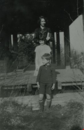
Audrey, Barbara and Basil Pontifex
https://search.heritageburnaby.ca/link/archivedescription37937
- Repository
- City of Burnaby Archives
- Date
- 1929 (date of original), copied 1991
- Collection/Fonds
- Burnaby Historical Society fonds
- Description Level
- Item
- Physical Description
- 1 photograph : b&w ; 4.3 x 2.8 cm print on contact sheet 20.5 x 26.7 cm
- Scope and Content
- Photograph of siblings (back to front) Audrey, Barbara and Basil Pontifex at their house at 4006 Douglas Road (old numbering) and Gilpin Street.
- Repository
- City of Burnaby Archives
- Date
- 1929 (date of original), copied 1991
- Collection/Fonds
- Burnaby Historical Society fonds
- Subseries
- Burnaby Image Bank subseries
- Physical Description
- 1 photograph : b&w ; 4.3 x 2.8 cm print on contact sheet 20.5 x 26.7 cm
- Description Level
- Item
- Record No.
- 370-524
- Access Restriction
- No restrictions
- Reproduction Restriction
- No known restrictions
- Accession Number
- BHS1999-03
- Scope and Content
- Photograph of siblings (back to front) Audrey, Barbara and Basil Pontifex at their house at 4006 Douglas Road (old numbering) and Gilpin Street.
- Media Type
- Photograph
- Notes
- Title based on contents of photograph
- 1 b&w copy negative accompanying
- Negative has a pink cast
- Geographic Access
- Gilpin Street
- Historic Neighbourhood
- Burnaby Lake (Historic Neighbourhood)
- Planning Study Area
- Douglas-Gilpin Area
Images
