Narrow Results By

Early maps of Burnaby
https://search.heritageburnaby.ca/link/archivedescription36450
- Repository
- City of Burnaby Archives
- Date
- 1990
- Collection/Fonds
- Burnaby Historical Society fonds
- Description Level
- Item
- Physical Description
- 1 photograph : col. ; 15 x 10 cm
- Scope and Content
- Photograph of a display that included early maps of the Burnaby area as part of the opening of the Burnaby Community Archives at the Burnaby Village Museum.
- Repository
- City of Burnaby Archives
- Date
- 1990
- Collection/Fonds
- Burnaby Historical Society fonds
- Subseries
- Donald N. Brown subseries
- Physical Description
- 1 photograph : col. ; 15 x 10 cm
- Description Level
- Item
- Record No.
- 271-018
- Access Restriction
- No restrictions
- Reproduction Restriction
- Reproduce for fair dealing purposes only
- Accession Number
- BHS1991-41
- Scope and Content
- Photograph of a display that included early maps of the Burnaby area as part of the opening of the Burnaby Community Archives at the Burnaby Village Museum.
- Subjects
- Documentary Artifacts - Maps
- Media Type
- Photograph
- Notes
- Title based on contents of photograph
- 1 photograph : col. negative ; 35 mm accompanying
- Geographic Access
- Deer Lake Avenue
- Street Address
- 6501 Deer Lake Avenue
- Historic Neighbourhood
- Burnaby Lake (Historic Neighbourhood)
- Planning Study Area
- Morley-Buckingham Area
Images

map
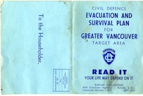
https://search.heritageburnaby.ca/link/museumartifact83653
- Repository
- Burnaby Village Museum
- Accession Code
- BV007.34.1
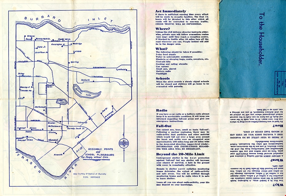
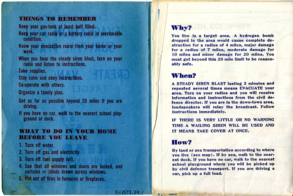
- Description
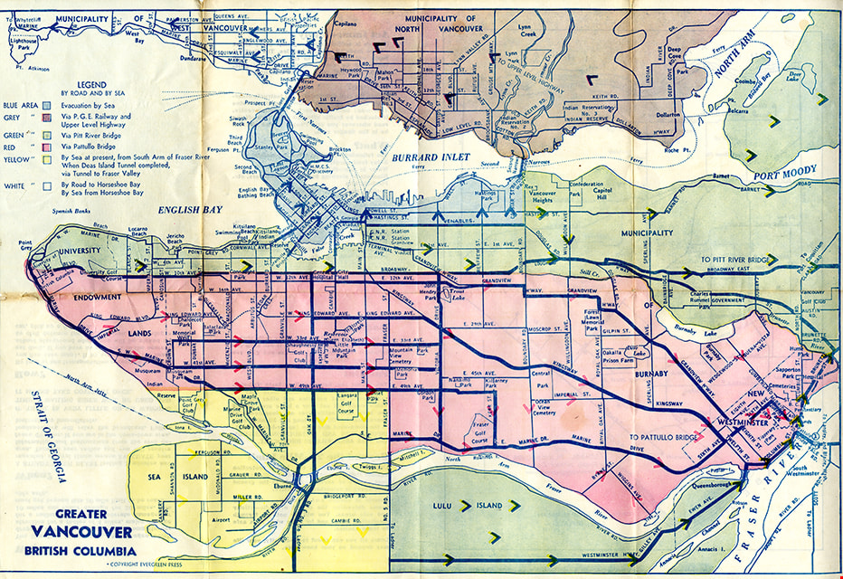
- Folded col. map within blue cover; printed both sides; Civil Defence Evacuation and Survival Plan - Map -- [1957] produced by Burnaby Civil Defence; title on front cover reads "CIVIL DEFENCE / EVACUATION AND SURVIVAL PLAN /FOR / GREATER VANCOUVER / TARGET AREA / READ IT / YOUR LIFE MAY DEPEND ON IT". Colour map inside is titled "GREATER / VANCOUVER / BRITISH COLUMBIA" and includes a legend with various evacuation routes by road and by sea; copyright Evergreen Press. Verso of map includes a map of Burnaby courtesy of District of Burnaby Civil Defence titled "ASSEMBLY POINTS / and / SCHOOL PLAYGROUNDS / for People without Cars" and detailed information about things to remember during an emergency evacuation.
- Object History
- Map was made available to citizens of Burnaby and was produced by Burnaby Civil Defence, 4000 Grandview Highway, Burnaby B.C.
- Category
- 08. Communication Artifacts
- Classification
- Documentary Artifacts - - Graphic Documents
- Object Term
- Cartograph, Map
- Colour
- Blue
- Measurements
- 30.5 x 34 cm folded to 15 x 11.5 cm
- Maker
- Evergreen Press Limited
- Country Made
- Canada
- Province Made
- British Columbia
- Publication Date
- Sept. 1957
- Names
- Burnaby Civil Defence
Images

Maps and charts on display
https://search.heritageburnaby.ca/link/archivedescription36451
- Repository
- City of Burnaby Archives
- Date
- 1990
- Collection/Fonds
- Burnaby Historical Society fonds
- Description Level
- Item
- Physical Description
- 1 photograph : col. ; 15 x 10 cm
- Scope and Content
- Photograph of maps and charts on display at the opening of the Burnaby Community Archives at the Burnaby Village Museum.
- Repository
- City of Burnaby Archives
- Date
- 1990
- Collection/Fonds
- Burnaby Historical Society fonds
- Subseries
- Donald N. Brown subseries
- Physical Description
- 1 photograph : col. ; 15 x 10 cm
- Description Level
- Item
- Record No.
- 271-019
- Access Restriction
- No restrictions
- Reproduction Restriction
- Reproduce for fair dealing purposes only
- Accession Number
- BHS1991-41
- Scope and Content
- Photograph of maps and charts on display at the opening of the Burnaby Community Archives at the Burnaby Village Museum.
- Subjects
- Documentary Artifacts - Maps
- Media Type
- Photograph
- Notes
- Title based on contents of photograph
- 1 photograph : col. negative ; 35 mm accompanying
- Geographic Access
- Deer Lake Avenue
- Street Address
- 6501 Deer Lake Avenue
- Historic Neighbourhood
- Burnaby Lake (Historic Neighbourhood)
- Planning Study Area
- Morley-Buckingham Area
Images

newsletter
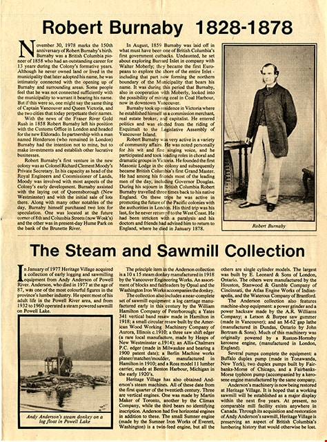
https://search.heritageburnaby.ca/link/museumartifact84683
- Repository
- Burnaby Village Museum
- Accession Code
- BV011.55.1
- Description
- Newsletter; created by Heritage Village Museum [1978]. Printed on newsprint, double sided, folded in centre. Newsletter also served as a map and guide of the village. The front page of the newsletter features articles "Robert Burnaby 1828 - 1878" and "The Steam and Sawmill Collection". The centre two pages open to a list of exhibits in the village with a site map. The back page includes "Operating Times"; "Heritage Village Calendar", and "Application for Membership" of the Century park Museum Association. Design and production by Dave Lovell.
- Object History
- Newsletter created by Heritage Village Museum (Burnaby Village Museum) and given out free to visitors. Design and production of the newsletter was created by Dave Lovell.
- Category
- 08. Communication Artifacts
- Classification
- Documentary Artifacts - - Other Documents
- Object Term
- Serial
- Colour
- Beige
- Measurements
- Height: 30 cm x Width: 44 cm folded to Height: 30 cm x Width: 22 cm
- Maker
- Heritage Village
- Country Made
- Canada
- Province Made
- British Columbia
- Site/City Made
- Burnaby
- Publication Date
- [1978]
Images