Narrow Results By
Creator
- Aveling, Eleanor Marx, 1855-1898 1
- British Columbia Underwriters' Association 9
- Cornish, George A. (George Augustus), 1872- 3
- Funk & Wagnalls Company 1
- G. Borwick & Sons 1
- Girl Guides of Canada 1
- Hall, H.S. (Henry Sinclair), 1848-1934 3
- Ibsen, Henrik, 1828-1906 1
- Johnston, Harry H. 1
- Knight, S.R. (Samuel Ratcliffe) 1
- Lee, Chue Kan "Cecil" 1
- Lee, Julie Cho Chan 1
Person / Organization
- Burnaby North High School 1
- Co-operative Commonwealth Federation "CCF" 1
- Douglas, Tommy 1
- Ehlers, Edith "Edie" Fleming 1
- Fleming, Frances "Fanny" Waplington 1
- Fleming, John "Jack" Reyland 1
- Fleming, John Reyland "Ray" 2
- Girl Guides of Canada 2
- Godwin, Florence Hart 1
- Kidd, Marion 1
- Love Family 1
- MacInnis, Grace 1
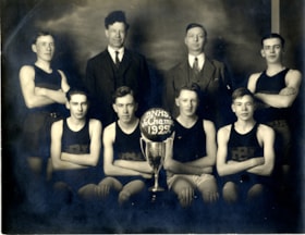
Burnaby North High School junior champs
https://search.heritageburnaby.ca/link/museumdescription5136
- Repository
- Burnaby Village Museum
- Date
- 1929
- Collection/Fonds
- Waplington family fonds
- Description Level
- Item
- Physical Description
- 1 photograph : sepia ; 15.5 x 20 cm
- Scope and Content
- Photograph of Burnaby North High School Junior Basketball team and champions of the Wilson Cup. The team and coaches are gathered together with their championship trophy for a group photograph. Ray Fleming is identified second from right in the front row sitting next to the trophy with a basket bal…
- Repository
- Burnaby Village Museum
- Collection/Fonds
- Waplington family fonds
- Description Level
- Item
- Physical Description
- 1 photograph : sepia ; 15.5 x 20 cm
- Scope and Content
- Photograph of Burnaby North High School Junior Basketball team and champions of the Wilson Cup. The team and coaches are gathered together with their championship trophy for a group photograph. Ray Fleming is identified second from right in the front row sitting next to the trophy with a basket ball balanced on top with the words "BNHS / Jr. Champs / 1929" painted on it. Other team members include J.Gemmel, W. Auld, D. Wright, F. Parker and A. Lawson. The team beat out Duke of Connaught High School of New Westminster in the championship game, 10-8 as the final score.
- Subjects
- Sports - Basketball
- Accession Code
- BV016.46.91
- Access Restriction
- No restrictions
- Reproduction Restriction
- No known restrictions
- Date
- 1929
- Media Type
- Photograph
- Scan Resolution
- 600
- Scan Date
- 13-Aug-2018
- Notes
- Title based on information contained within photograph album
- Note in pencil on verso of photograph reads: "3_Col"
- Photograph is part of Photograph album BV016.46.52
- See also City of Burnaby Archives Photograph no. 476-015
Images

Municipality of Burnaby - Volume XV and Volume XVIII
https://search.heritageburnaby.ca/link/museumdescription8680
- Repository
- Burnaby Village Museum
- Date
- May 1927
- Collection/Fonds
- Burnaby Village Museum Map collection
- Description Level
- File
- Physical Description
- 4 plans on 4 sheets : col. lithographic prints ; 63.5 x 53.5 cm folded to 53 x 31.5 cm
- Scope and Content
- File consists of four pages of plans removed from a bound book containing a series of fire insurance plans of the Municipality of Burnaby. The first two pages are numbered "A" and "B" and are key plans from "GREATER VANCOUVER B.C. / VOLUME XV / Surveyed _ May 1927 / MUNICIPALITY OF / BURNABY", "PLA…
- Repository
- Burnaby Village Museum
- Collection/Fonds
- Burnaby Village Museum Map collection
- Description Level
- File
- Physical Description
- 4 plans on 4 sheets : col. lithographic prints ; 63.5 x 53.5 cm folded to 53 x 31.5 cm
- Material Details
- Scales [1:1200] and [1:6000]
- Scope and Content
- File consists of four pages of plans removed from a bound book containing a series of fire insurance plans of the Municipality of Burnaby. The first two pages are numbered "A" and "B" and are key plans from "GREATER VANCOUVER B.C. / VOLUME XV / Surveyed _ May 1927 / MUNICIPALITY OF / BURNABY", "PLAN DEPT. FIRE BRANCH _ B.C. INSURANCE UNDERWRITERS ASSN.". Key Plan "B" covers plans: 1505; 1506; 1512 to 1516; 1540 to 1544; 1550 to 1557 and District Lots: 129 to 132; 135 to 138; 205 to 208 and 215 to 218. Key Plan "A" covers plans: 1501 to 1504; 1507 to 1511; 1517 to 1525; 1531 to 1539; 1545 to 1550 and District Lots: 116 to 127 and 186 to 189. Plan "1806" is part of "GREATER VANCOUVER B.C. / VOLUME XVIII / Municipality of Burnaby / May, 1927" and covers District Lot 153. Plan "1807" is from "GREATER VANCOUVER B.C. / VOLUME XVIII / Municipality of Burnaby / May, 1927" and covers District Lots: 99,149 and 152.
- Responsibility
- British Columbia Underwriters' Association
- Accession Code
- HV972.111.2
- Access Restriction
- No restrictions
- Reproduction Restriction
- May be restricted by third party rights
- Date
- May 1927
- Media Type
- Cartographic Material
- Historic Neighbourhood
- Vancouver Heights (Historic Neighbourhood)
- Lochdale (Historic Neighbourhood)
- Capitol Hill (Historic Neighbourhood)
- Central Park (Historic Neighbourhood)
- Alta Vista (Historic Neighbourhood)
- Planning Study Area
- Burnaby Heights Area
- Sperling-Broadway Area
- Lochdale Area
- Parkcrest-Aubrey Area
- Westridge Area
- Willingdon Heights Area
- Capitol Hill Area
- Maywood Area
- Marlborough Area
- Scan Resolution
- 400
- Scan Date
- 2021-11-18
- Notes
- Title based on content of plans
- Scales are measured 1 inch = 100 feet and 1 inch = 500 feet
- See also BV987.1.70d for revised versions of plans
Zoomable Images


Municipality of Burnaby - Volume XV and Volume XVIII
https://search.heritageburnaby.ca/link/museumdescription8681
- Repository
- Burnaby Village Museum
- Date
- May 1927
- Collection/Fonds
- Burnaby Village Museum Map collection
- Description Level
- File
- Physical Description
- 4 plans on 4 sheets : col. lithographic prints, ms. annotations in blue ink ; 63.5 x 53.5 cm folded to 53 x 31.5 cm
- Scope and Content
- File consists of four pages of plans removed from a bound book containing a series of fire insurance plans of the Municipality of Burnaby. Plan "1507" and plan "1517" are from "GREATER VANCOUVER B.C. / VOLUME XV / Municipality of Burnaby / May, 1927". Plan "1507" covers District Lot 186 and plan "1…
- Repository
- Burnaby Village Museum
- Collection/Fonds
- Burnaby Village Museum Map collection
- Description Level
- File
- Physical Description
- 4 plans on 4 sheets : col. lithographic prints, ms. annotations in blue ink ; 63.5 x 53.5 cm folded to 53 x 31.5 cm
- Material Details
- Scale [1:600] and [1:1200]
- Scope and Content
- File consists of four pages of plans removed from a bound book containing a series of fire insurance plans of the Municipality of Burnaby. Plan "1507" and plan "1517" are from "GREATER VANCOUVER B.C. / VOLUME XV / Municipality of Burnaby / May, 1927". Plan "1507" covers District Lot 186 and plan "1517" covers District Lot 116. Plan "1804" and plan "1805" are from "GREATER VANCOUVER B.C. / VOLUME XVIII / Municipality of Burnaby / May, 1927". Plans "1804" and "1805" cover District Lot 153.
- Responsibility
- British Columbia Underwriters' Association
- Accession Code
- HV972.111.3
- Access Restriction
- No restrictions
- Reproduction Restriction
- May be restricted by third party rights
- Date
- May 1927
- Media Type
- Cartographic Material
- Historic Neighbourhood
- Central Park (Historic Neighbourhood)
- Vancouver Heights (Historic Neighbourhood)
- Planning Study Area
- Maywood Area
- Willingdon Heights Area
- Scan Resolution
- 400
- Scan Date
- 2021-11-18
- Notes
- Title based on content of plans
- See also BV987.1.70d for revised versions of plans
- Scale is measured 1 inch = 100 feet
Images


![Municipality of Burnaby - Volume XV and Volume XVIII, 1927-[1940] thumbnail](/media/hpo/_Data/_BVM_Artifacts/1972/1972_0111_0004_003.jpg?width=280)
Municipality of Burnaby - Volume XV and Volume XVIII
https://search.heritageburnaby.ca/link/museumdescription8682
- Repository
- Burnaby Village Museum
- Date
- 1927-[1940]
- Collection/Fonds
- Burnaby Village Museum Map collection
- Description Level
- File
- Physical Description
- 4 plans on 4 sheets: col. lithographic prints ; 63.5 x 53.5 cm folded to 53 x 31.5 cm
- Scope and Content
- File consists of four pages of plans removed from a bound book containing a series of fire insurance plans of the Municipality of Burnaby. Plan "1518" and "1519" are from "GREATER VANCOUVER B.C. / VOLUME XV / Municipality of Burnaby / May, 1927". Plan "1518" covers District Lot 116 and Plan "1519"…
- Repository
- Burnaby Village Museum
- Collection/Fonds
- Burnaby Village Museum Map collection
- Description Level
- File
- Physical Description
- 4 plans on 4 sheets: col. lithographic prints ; 63.5 x 53.5 cm folded to 53 x 31.5 cm
- Material Details
- Scale [1:600]
- Scope and Content
- File consists of four pages of plans removed from a bound book containing a series of fire insurance plans of the Municipality of Burnaby. Plan "1518" and "1519" are from "GREATER VANCOUVER B.C. / VOLUME XV / Municipality of Burnaby / May, 1927". Plan "1518" covers District Lot 116 and Plan "1519" covers District Lot 121. Plan "1802" and plan "1803" are from "GREATER VANCOUVER B.C. / VOLUME XVIII / Municipality of Burnaby / May, 1927". Both plans "1802" and "1803" cover District Lot 153.
- Responsibility
- British Columbia Underwriters' Association
- Accession Code
- HV972.111.4
- Access Restriction
- No restrictions
- Reproduction Restriction
- May be restricted by third party rights
- Date
- 1927-[1940]
- Media Type
- Cartographic Material
- Historic Neighbourhood
- Vancouver Heights (Historic Neighbourhood)
- Central Park (Historic Neighbourhood)
- Planning Study Area
- Willingdon Heights Area
- Marlborough Area
- Scan Resolution
- 400
- Scan Date
- 2021-11-18
- Notes
- Title based on content of plans
- See also BV987.1.70d for revised versions of plans
- Scale is measured 1 inch = 50 feet
- Contact Burnaby Village Museum to access plans 1518 and 1519 (these plans have revisions on top - date of revisions is uncertain)
Images
![Municipality of Burnaby - Volume XV and Volume XVIII, 1927-[1940] thumbnail](/media/hpo/_Data/_BVM_Artifacts/1972/1972_0111_0004_003.jpg)


Municipality of Burnaby - Volume XVIII and Volume XIX
https://search.heritageburnaby.ca/link/museumdescription8683
- Repository
- Burnaby Village Museum
- Date
- May 1927
- Collection/Fonds
- Burnaby Village Museum Map collection
- Description Level
- File
- Physical Description
- 2 plans on 2 sheets : col. lithographic prints ; 63.5 x 53.5 cm folded to 53 x 31.5 cm
- Scope and Content
- File consists of two pages of plans removed from a bound book containing a series of fire insurance plans of the Municipality of Burnaby. Plan "1832" is from "GREATER VANCOUVER B.C. / VOLUME XVIII / Municipality of Burnaby / May, 1927" and covers District Lots: 98 and 28. Plan "K" is part of a key …
- Repository
- Burnaby Village Museum
- Collection/Fonds
- Burnaby Village Museum Map collection
- Description Level
- File
- Physical Description
- 2 plans on 2 sheets : col. lithographic prints ; 63.5 x 53.5 cm folded to 53 x 31.5 cm
- Material Details
- Scale [1:1200] to [1:6000]
- Scope and Content
- File consists of two pages of plans removed from a bound book containing a series of fire insurance plans of the Municipality of Burnaby. Plan "1832" is from "GREATER VANCOUVER B.C. / VOLUME XVIII / Municipality of Burnaby / May, 1927" and covers District Lots: 98 and 28. Plan "K" is part of a key plan "GREATER VANCOUVER B.C. / Surveyed VOLUME XIX May 1927 / MUNICIPALITY OF / BURNABY / PLAN DEPT. British Columbia Ins. Underwriters Association / FIRE BRANCH / KEY PLAN", "Scale 500 FT = 1 INCH / FOR REPORT SEE VOL. XV" covering plans: 1901 to 1914 and District Lots: 161; 164 to 167; 155c; 155; 172 and 173.
- Responsibility
- British Columbia Underwriters' Association
- Accession Code
- HV972.111.5
- Access Restriction
- No restrictions
- Reproduction Restriction
- May be restricted by third party rights
- Date
- May 1927
- Media Type
- Cartographic Material
- Historic Neighbourhood
- East Burnaby (Historic Neighbourhood)
- Central Park (Historic Neighbourhood)
- Fraser Arm (Historic Neighbourhood)
- Alta Vista (Historic Neighbourhood)
- Planning Study Area
- Windsor Area
- Marlborough Area
- Second Street Area
- Big Bend Area
- Sussex-Nelson Area
- Scan Resolution
- 400
- Scan Date
- 2021-11-18
- Notes
- Title based on content of plans
- See also BV987.1.70d for revised versions of plans
- Scale is measured 1 inch = 500 feet
Zoomable Images


Municipality of Burnaby - Volume XVI and Volume XVII
https://search.heritageburnaby.ca/link/museumdescription8684
- Repository
- Burnaby Village Museum
- Date
- May 1927
- Collection/Fonds
- Burnaby Village Museum Map collection
- Description Level
- File
- Physical Description
- 4 plans on 4 sheets : col. lithographic prints ; 63.5 x 53.5 cm folded to 53 x 31.5 cm
- Scope and Content
- File consists of four pages of plans removed from a bound book containing a series of fire insurance plans of the Municipality of Burnaby. Page "D" is titled: "GREATER VANCOUVER B.C. / VOLUME XVI / Surveyed _ May 1927 / MUNICIPALITY OF / BURNABY / PLAN DEPT. FIRE BRANCH _ B.C. INSURANCE UNDERWRITE…
- Repository
- Burnaby Village Museum
- Collection/Fonds
- Burnaby Village Museum Map collection
- Description Level
- File
- Physical Description
- 4 plans on 4 sheets : col. lithographic prints ; 63.5 x 53.5 cm folded to 53 x 31.5 cm
- Material Details
- Scale [1:1200] and [1:6000]
- Scope and Content
- File consists of four pages of plans removed from a bound book containing a series of fire insurance plans of the Municipality of Burnaby. Page "D" is titled: "GREATER VANCOUVER B.C. / VOLUME XVI / Surveyed _ May 1927 / MUNICIPALITY OF / BURNABY / PLAN DEPT. FIRE BRANCH _ B.C. INSURANCE UNDERWRITERS ASSN." / KEY PLAN". Plans covered in this "Key Plan" are numbered 1601 to 1626, 1632 and 1651 covering District Lots: 15; 31; 100 to 102; 114; 141 to 144; 147 and 148; 209 to 214. Plan "E" is part of "GREATER VANCOUVER B.C. / VOLUME XVII / Municipality of Burnaby / May 1927" and covers plans: 1701 to 1705; 1711 to 1715; 1723 to 1727; 1729 to 1733; 1737 to 1742 and District Lots: 68 to 74; 80 to 84; 32 to 35 and 38 to 39. Plan marked "F" is a key plan titled: "GREATER VANCOUVER B.C. / VOLUME XVII / Surveyed _ May 1927 / MUNICIPALITY OF / BURNABY and covers plans: 1706 to 1710; 1716 to 1722; 1734 and 1735; 1743 to 1752 and District Lots: 42 to 44; 59; 75 to 80; 83 to 87; 89 to 93 and 130. Plan "1729" is part of "GREATER VANCOUVER B.C. / VOLUME XVII / Municipality of Burnaby / May 1927" and covers District Lots 34 and 35.
- Responsibility
- British Columbia Underwriters' Association
- Accession Code
- HV972.111.6
- Access Restriction
- No restrictions
- Reproduction Restriction
- May be restricted by third party rights
- Date
- May 1927
- Media Type
- Cartographic Material
- Historic Neighbourhood
- Barnet (Historic Neighbourhood)
- Burquitlam (Historic Neighbourhood)
- Central Park (Historic Neighbourhood)
- Burnaby Lake (Historic Neighbourhood)
- Broadview (Historic Neighbourhood)
- Planning Study Area
- Burnaby Mountain Area
- Lyndhurst Area
- Lake City Area
- Cascade-Schou Area
- Garden Village Area
- Douglas-Gilpin Area
- Oakalla Area
- Scan Resolution
- 400
- Scan Date
- 2021-11-18
- Notes
- Title based on content of plans
- See also BV987.1.70d for revised versions of plans
- Scale is measured 1 inch = 500 feet
Zoomable Images


Municipality of Burnaby - Volume XV, Volume XVI, Volume XVII, Volume XVIII
https://search.heritageburnaby.ca/link/museumdescription8685
- Repository
- Burnaby Village Museum
- Date
- May 1927
- Collection/Fonds
- Burnaby Village Museum Map collection
- Description Level
- File
- Physical Description
- 4 plans on 4 sheets : col. lithographic prints ; 63.5 x 53.5 cm folded to 53 x 31.5 cm
- Scope and Content
- File consists of four pages of plans removed from a bound book containing a series of fire insurance plans of the Municipality of Burnaby. Plan "1531" is part of "GREATER VANCOUVER B.C. / VOLUME XV / Municipality of Burnaby / May 1927" and covers District Lots: 116 and 117. Key Plan "C" is part of …
- Repository
- Burnaby Village Museum
- Collection/Fonds
- Burnaby Village Museum Map collection
- Description Level
- File
- Physical Description
- 4 plans on 4 sheets : col. lithographic prints ; 63.5 x 53.5 cm folded to 53 x 31.5 cm
- Material Details
- Scale [1:600] and [1:1200]
- Scope and Content
- File consists of four pages of plans removed from a bound book containing a series of fire insurance plans of the Municipality of Burnaby. Plan "1531" is part of "GREATER VANCOUVER B.C. / VOLUME XV / Municipality of Burnaby / May 1927" and covers District Lots: 116 and 117. Key Plan "C" is part of "GREATER VANCOUVER B.C. / VOLUME XVI / Municipality of Burnaby / May 1927" and covers plans 1623 to 1651 and District Lots: 1 and 2; 4; 6; 8; 10 to 14; 25; 27; 40; 56 to 58; 88 and 89. Plan "1738" is part of "GREATER VANCOUVER B.C. / VOLUME XVII / Municipality of Burnaby / May 1927" and covers District Lots: 34 and 35. Key plan "G" is part of "GREATER VANCOUVER B.C. / VOLUME XVIII / Municipality of Burnaby / May 1927" and covers plans: 1801 to 1813; 1823; 1824; 1833 to 1838; 1841 to 1853 and District Lots: 32; 93; 94; 97 to 99; 149; 150; 152; 155 to 159; 161 to 164.
- Responsibility
- British Columbia Underwriters' Association
- Accession Code
- HV972.111.7
- Access Restriction
- No restrictions
- Reproduction Restriction
- May be restricted by third party rights
- Date
- May 1927
- Media Type
- Cartographic Material
- Historic Neighbourhood
- Central Park (Historic Neighbourhood)
- Fraser Arm (Historic Neighbourhood)
- Alta Vista (Historic Neighbourhood)
- Broadview (Historic Neighbourhood)
- Vancouver Heights (Historic Neighbourhood)
- Burquitlam (Historic Neighbourhood)
- East Burnaby (Historic Neighbourhood)
- Edmonds (Historic Neighbourhood)
- Lozells (Historic Neighbourhood)
- Planning Study Area
- Clinton-Glenwood Area
- Marlborough Area
- Maywood Area
- Windsor Area
- Big Bend Area
- Garden Village Area
- Willingdon Heights Area
- West Central Valley Area
- Cariboo-Armstrong Area
- Lyndhurst Area
- Cameron Area
- Lake City Area
- Edmonds Area
- Second Street Area
- Sperling-Broadway Area
- Lakeview-Mayfield Area
- Scan Resolution
- 400
- Scan Date
- 2021-11-18
- Notes
- Title based on content of plans
- See also BV987.1.70d for revised versions of plans
- Scale is measured 1 inch = 500 feet
Zoomable Images

Municipality of Burnaby - Volume XV, Volume XVI, Volume XVII, Volume XVIII, May 1927
Zoom into Image

Municipality of Burnaby- Volume XV and Volume XVIII
https://search.heritageburnaby.ca/link/museumdescription8686
- Repository
- Burnaby Village Museum
- Date
- May 1927
- Collection/Fonds
- Burnaby Village Museum Map collection
- Description Level
- File
- Physical Description
- 4 plans on 4 sheets : col. lithographic prints ; 63.5 x 53.5 cm folded to 53 x 31.5 cm
- Scope and Content
- File consists of four pages of plans removed from a bound book containing a series of fire insurance plans of the Municipality of Burnaby. Plan "1520" is part of "GREATER VANCOUVER B.C. / VOLUME XV / Municipality of Burnaby / May 1927" and covers District Lots: 121 and 187. Plann "1521" is part of …
- Repository
- Burnaby Village Museum
- Collection/Fonds
- Burnaby Village Museum Map collection
- Description Level
- File
- Physical Description
- 4 plans on 4 sheets : col. lithographic prints ; 63.5 x 53.5 cm folded to 53 x 31.5 cm
- Material Details
- Scale [1:600] and [1:1200]
- Scope and Content
- File consists of four pages of plans removed from a bound book containing a series of fire insurance plans of the Municipality of Burnaby. Plan "1520" is part of "GREATER VANCOUVER B.C. / VOLUME XV / Municipality of Burnaby / May 1927" and covers District Lots: 121 and 187. Plann "1521" is part of "GREATER VANCOUVER B.C. / VOLUME XV / Municipality of Burnaby / May 1927" and covers District Lots: 121 and 187. Key plan "H" reads: "GREATER VANCOUVER B.C. / VOLUME XVIII / Surveyed _ May 1927 / MUNICIPALITY OF / BURNABY" and covers plans: 1813 to 1822; 1824 to 1832; 1839; 1840; 1853 to 1865 and District Lots: 28; 30; 53; 90 to 93; 95 to 97; 155a; 155b; 155c; 159; 160; 171 to 173. Plan "1801" is part of "GREATER VANCOUVER B.C. / VOLUME XVIII / Municipality of Burnaby / May 1927" and covers District Lot 153.
- Responsibility
- British Columbia Underwriters' Association
- Accession Code
- HV972.111.8
- Access Restriction
- No restrictions
- Reproduction Restriction
- May be restricted by third party rights
- Date
- May 1927
- Media Type
- Cartographic Material
- Historic Neighbourhood
- Fraser Arm (Historic Neighbourhood)
- Vancouver Heights (Historic Neighbourhood)
- East Burnaby (Historic Neighbourhood)
- Edmonds (Historic Neighbourhood)
- Planning Study Area
- Marlborough Area
- Kingsway-Beresford Area
- Windsor Area
- Big Bend Area
- Clinton-Glenwood Area
- Burnaby Heights Area
- Edmonds Area
- Stride Avenue Area
- Scan Resolution
- 400
- Scan Date
- 2021-11-18
- Notes
- Title based on content of plans
- See also BV987.1.70d for revised versions of plans
- Scale is measured 1 inch = 500 feet
Zoomable Images


Municipality of Burnaby - Volume XVIII
https://search.heritageburnaby.ca/link/museumdescription8687
- Repository
- Burnaby Village Museum
- Date
- May 1927
- Collection/Fonds
- Burnaby Village Museum Map collection
- Description Level
- File
- Physical Description
- 2 plans on 2 sheets : col. lithographic prints; 63.5 x 53.5 cm folded to 53 x 31.5 cm
- Scope and Content
- File consists of two pages of plans removed from a bound book containing a series of fire insurance plans of the Municipality of Burnaby. Plan "1819" and Plan "1820 are part of "GREATER VANCOUVER B.C. / VOLUME XVIII / Municipality of Burnaby / May 1927. Plan "1819" covers District Lot 95 and plan …
- Repository
- Burnaby Village Museum
- Collection/Fonds
- Burnaby Village Museum Map collection
- Description Level
- File
- Physical Description
- 2 plans on 2 sheets : col. lithographic prints; 63.5 x 53.5 cm folded to 53 x 31.5 cm
- Material Details
- Scales [1:600]
- Scope and Content
- File consists of two pages of plans removed from a bound book containing a series of fire insurance plans of the Municipality of Burnaby. Plan "1819" and Plan "1820 are part of "GREATER VANCOUVER B.C. / VOLUME XVIII / Municipality of Burnaby / May 1927. Plan "1819" covers District Lot 95 and plan "1820" covers District Lots 30 and 95.
- Responsibility
- British Columbia Underwriters' Association
- Accession Code
- HV972.111.38
- Access Restriction
- No restrictions
- Reproduction Restriction
- May be restricted by third party rights
- Date
- May 1927
- Media Type
- Cartographic Material
- Historic Neighbourhood
- Edmonds (Historic Neighbourhood)
- Highland Park (Historic Neighbourhood)
- Planning Study Area
- Stride Hill Area
- Kingsway-Beresford Area
- Scan Resolution
- 400
- Scan Date
- 2021-11-18
- Notes
- Title based on content of plans
- Scales are measured 1 inch = 50 feet
- See also BV987.1.70d for revised versions of plans
Images


Fire insurance plans - Greater Vancouver - Volume XV - Municipality of Burnaby
https://search.heritageburnaby.ca/link/museumdescription17795
- Repository
- Burnaby Village Museum
- Date
- 1927-1940
- Collection/Fonds
- Burnaby Village Museum Map collection
- Description Level
- Item
- Physical Description
- 11 plans on 8 sheets : col. lithographic print ; 64 x 54 cm
- Scope and Content
- Item consists of fire insurance plans titled "Greater Vancouver / Volume XV / Municipality / of Burnaby" surveyed May 1927 and revised October 1940. Volume XV includes a two page Key Plan (A and B) identifying associated plan numbers and district lots and nine numbered fire insurance plans identifi…
- Repository
- Burnaby Village Museum
- Collection/Fonds
- Burnaby Village Museum Map collection
- Description Level
- Item
- Physical Description
- 11 plans on 8 sheets : col. lithographic print ; 64 x 54 cm
- Material Details
- Scales between [1:600] and [1:6000]
- Scope and Content
- Item consists of fire insurance plans titled "Greater Vancouver / Volume XV / Municipality / of Burnaby" surveyed May 1927 and revised October 1940. Volume XV includes a two page Key Plan (A and B) identifying associated plan numbers and district lots and nine numbered fire insurance plans identified as; 1507; 1508 ; 1517; 1518; 1519; 1520;1521; 1531and 1532.
- Publisher
- Plan Department of Fire Branch of British Columbia Underwriters' Association
- Accession Code
- BV987.1.70
- Access Restriction
- No restrictions
- Reproduction Restriction
- May be restricted by third party rights
- Date
- 1927-1940
- Media Type
- Cartographic Material
- Historic Neighbourhood
- Vancouver Heights (Historic Neighbourhood)
- Planning Study Area
- Burnaby Heights Area
- Willingdon Heights Area
- Scan Resolution
- 400
- Notes
- Title based on contents of item
- These plans are contained within a bound book with labels on cover page reading: "Plan No. 90 / THIS INSURANCE PLAN / of / Vancouver VOLUME "8" / IN THE PROPERTY OF THE / British Columbia Insurance Underwriter's Association / Vancouver B.C. / AND IS LOANED / MELVILLE F. THOMSON CO. .../ Date May 26th, 1934"; / "Plan No. 74 / THIS INSURANCE PLAN / OF / VANCOUVER VOLUME "9"" / Plan No. 11 / THIS INSURANCE PLAN / OF / BURNABY VOLUMES 15-19" / "THIS PLAN IS THE PROPERTY OF / THE / BRITISH LAW INSURANCE COMPANY / LIMITED"
- Fire insurance plans cover various district lots in Burnaby including: District Lot 116,121, 186 and 187.
- Sticker adhered to Key Plan B reads: "
- Contact Burnaby Village Museum to view fire insurance plans that are part of Volume XV
The Literary digest atlas of the world and gazetteer
https://search.heritageburnaby.ca/link/museumlibrary1694
- Repository
- Burnaby Village Museum
- Author
- Funk & Wagnalls Company
- Publication Date
- 1927
- Call Number
- 912 FUN
- Repository
- Burnaby Village Museum
- Collection
- Special Collection
- Material Type
- Book
- Accession Code
- BV985.5211.1
- Call Number
- 912 FUN
- Author
- Funk & Wagnalls Company
- Place of Publication
- New York
- Publisher
- Funk & Wagnalls Company
- Publication Date
- 1927
- Physical Description
- 192 p. : col. maps ; 25 cm.
- Library Subject (LOC)
- Atlases
- Notes
- "Containing new maps of the principal countries of the world and separate maps of each Amercian state and territory, the Canadian provinces, etc., etc.; accompanied by individual indexes of each state, province, etc., and a descriptive gazetteer of the principal countries of the world" --title page.
- Maps by C.S. Hammond Co.
![50th Anniversary G.G.C., [1926-1979] thumbnail](/media/hpo/_Data/_BVM_Images/2015/2015_0035_0166_folded_redacted.jpg?width=280)
50th Anniversary G.G.C.
https://search.heritageburnaby.ca/link/museumdescription4594
- Repository
- Burnaby Village Museum
- Date
- [1926-1979]
- Collection/Fonds
- Burnaby Girl Guides fonds
- Description Level
- File
- Physical Description
- 1 scrapbook (51 photographs + 1 postcard + textual records)
- Scope and Content
- File consists of a scrapbook with a handpainted wood cover titled "50th Anniversary / G.G.C". The scrapbook documents events and ceremonies of the 4th Guide Company with the first half of the scrapbook containing photographs and documents regarding the 50th Anniversary of Girl Guides which was cele…
- Repository
- Burnaby Village Museum
- Collection/Fonds
- Burnaby Girl Guides fonds
- Description Level
- File
- Physical Description
- 1 scrapbook (51 photographs + 1 postcard + textual records)
- Scope and Content
- File consists of a scrapbook with a handpainted wood cover titled "50th Anniversary / G.G.C". The scrapbook documents events and ceremonies of the 4th Guide Company with the first half of the scrapbook containing photographs and documents regarding the 50th Anniversary of Girl Guides which was celebrated at St. Nicholas Church in 1960 while the second half documents earlier events from 1926, as well as other events in the 1960s such as; "Year of the Golden Jubilee", a parade in North Burnaby as well as Thinking Day 1976-1978, banquets, a disco contest, camping on Hollyburn mountain and a visit to Victoria in 1979. On November 3rd, 1926 the company was registered as the 5th Burnaby Guide company, in 1951 the number was changed to the 4th Vancouver Guide Company and in 1956 the number was changed to the 4th Burnaby Company.
- Accession Code
- BV015.35.166
- Access Restriction
- No restrictions
- Reproduction Restriction
- May be restricted by third party rights
- Date
- [1926-1979]
- Media Type
- Textual Record
- Photograph
- Notes
- Transcribed title
- Items within scrapbook have been redacted in compliance with Section 22 of FIPPA
- A selection of photographs are described at item level (BV015.35.285 to BV.015.35.300).
Images
![50th Anniversary G.G.C., [1926-1979] thumbnail](/media/hpo/_Data/_BVM_Images/2015/2015_0035_0166_folded_redacted.jpg)
Documents
The Canadian school atlas : containing seventy-three maps (including seven classical maps) and complete index
https://search.heritageburnaby.ca/link/museumlibrary1710
- Repository
- Burnaby Village Museum
- Edition
- Rev. and enl. ed.
- Publication Date
- 1926
- Call Number
- 912 CAN Copy 1
- Repository
- Burnaby Village Museum
- Collection
- Special Collection
- Material Type
- Book
- Accession Code
- HV984.21.23
- Call Number
- 912 CAN Copy 1
- Edition
- Rev. and enl. ed.
- Contributor
- Cornish, George A. (George Augustus), 1872-
- Place of Publication
- Toronto
- Publisher
- J. M. Dent & Sons Limited
- Publication Date
- 1926
- Printer
- Temple Press
- Physical Description
- [58], 32 p. : col. maps ; 29 cm.
- Inscription
- "Vera Morrow '36" [handwritten in black ink on front pastedown] "Vera Morrow" [handwritten twice in pencil on front pastedown] "716" [stamped in faded ink on front pastedown] "V.Z.M." [stamped in black ink on front and back endpaper] "Vera Morrow Geography Book Atlas" [handwritten three times in red and blue ink and pencil on front endpaper] "716" [stamped in black ink on front endpaper] Two hand drawn sketches of women in pencil on front endpaper. Clipping from Wed. April 1, 1959 Vancouver Sun showing "New route to border opening about May 15" found next to title page. enclosed in polyester film sleeve Hand drawn sketch of advertisement for Cunard Steamship Lines trip from New York to Havana. Found between p. 20-21 of index. "Vera Morrow Canadian School Atlas J.M. Dent + Sons" [handwritten twice in red ink and pencil on page after p. 32 of index] Three hand drawn sketches of women in pencil on page after p. 32 of index. "Vera Morrow" [handwritten in dark ink on back endpaper] Folded map of British Isles found inside back cover printed by F. P. Lloyd, Toronto, Canada
- Library Subject (LOC)
- Atlases--Canadian
- Historical geography--Maps
- Canada--History--Study and teaching
- Atlases
- Notes
- "Recommended for use in the High Schools of Ontario" --Title page.
- "Authorised for use in the schools of Nova Scotia, Quebec, Saskatchewan and British Columbia" --Title page.
- "Prepared at the Edinburgh Geographical Institute" --Half-title verso.
- "Under the editorship of George A. Cornish" --Half-title verso.
- "Companion to the 'Canadian school geography'" --Half-title verso.
- Copy 1 of 2.
- Editor's given name and dates: Cornish, George A. (George Augustus), 1872-1960
The Canadian school atlas : containing seventy-three maps with complete index
https://search.heritageburnaby.ca/link/museumlibrary189
- Repository
- Burnaby Village Museum
- Edition
- Rev. and enl. ed.
- Publication Date
- 1925
- Call Number
- 912 COR
- Repository
- Burnaby Village Museum
- Collection
- Special Collection
- Material Type
- Book
- Accession Code
- HV971.120.25
- Call Number
- 912 COR
- Edition
- Rev. and enl. ed.
- Contributor
- Cornish, George A. (George Augustus), 1872-
- Place of Publication
- Toronto
- Publisher
- J. M. Dent & Sons, Ltd.
- Publication Date
- 1925
- Printer
- The Temple Press
- Physical Description
- 1 v. (multiple pagings) : col. ill. (maps) : 29 cm.
- Inscription
- "This Book Cover is presented with the / compliments of / The Royal Bank of Canada", printed on front of jacket. Atlas / Peggy McKay / Florence Nightingale School / Vancouver BC" hand written on front of dust jacket. "Peggy McKay" [Handwritten in black ink on outside envelope] "Billy McKay 409-15th Av. East Vancouver B.C. Canada" [Handwritten in pencil on front endpaper] "Jack McLennan" [Handwritten in pencil on front endpaper] "Oh dear Baby face Drawn by Peggy McKay" [Handwritten in pencil around drawing of a woman's face on front endpaper] "Peggy McKay Florence Nightingale Vancouver B.C. Canada" [Handwritten in blue ink on front flyleaf] "Along came you, sweet little you, Just like a flower you came. You came into my heart never to leave me + never to part." [Handwritten in pencil on title page] "Liar" [Handwritten in pencil on title page] "867-5309" [Handwritten in pencil on contents verso] "Jenny's number... 867-5309, 867-5309 I got it, I got it, I got you number on the wa-ll I got, I got it, for a good time for a good time CALL" [Handwritten on contents verso] Handwritten story from front flyleaf to pre-title page verso (4 pages) Drawing of woman's face on front flyleaf. Song lyrics handwritten in blue ink on title page verso and opposite contents. List of names under the index, page 32.
- Library Subject (LOC)
- Atlases--Canadian
- Historical geography--Maps
- Canada--History--Study and teaching
- Atlases
- Notes
- Includes index.
- "Under the editorship of George A. Cornish" -- Pre Title-Page Verso
- "Prepared at the Edinburgh Geographical Institute to form a companion to the 'Canadian School Geography'" -- Pre Title-Page Verso
- "Authorized for use in the schools of the provinces of Nova Scotia, Quebec, Saskatchewan and British Columbia" -- Cover
- Contributor's full name and date as follows:George A Cornish (George Augustus), 1872-1960
Elementary algebra for schools containing a full treatment of graphs, with answers
https://search.heritageburnaby.ca/link/museumlibrary3627
- Repository
- Burnaby Village Museum
- Edition
- New ed., rev. and enl.
- Publication Date
- 1925
- Call Number
- 512 HAL 1907
- Repository
- Burnaby Village Museum
- Collection
- Special Collection
- Material Type
- Book
- Accession Code
- BV994.3.10
- Call Number
- 512 HAL 1907
- Edition
- New ed., rev. and enl.
- Place of Publication
- London
- Publisher
- MacMillan and Co., Limited
- Publication Date
- 1925
- Printer
- Robert Maclehose and Co. Ltd.
- Physical Description
- viii, 516 p. : diagrs. ; 18 cm.
- Inscription
- "Margaret Springate" [phrase is crossed out and handwritten in faded black ink on front endpaper] "May Graham Div 13" [handwritten in faded black ink on front endpaper] "Nixon's Book Store New Westminster, B.C." [stamped in faded purple ink on back endpaper] Study notes written on back endpaper in blue ink.
- Library Subject (LOC)
- Mathematics--Historical texts
- Algebra
- Mathematics--Textbooks
- Notes
- Author's given name and dates: Hall, H. S. (Henry Sinclair), 1848-1934
- Author's given name: Knight, S. R. (Samuel Ratcliffe)
Test cricket: a unique record of England v. Australia matches (1877-1921)
https://search.heritageburnaby.ca/link/museumlibrary1557
- Repository
- Burnaby Village Museum
- Author
- Sparks, William P.H.
- Edition
- 2nd ed.
- Publication Date
- 1924
- Call Number
- 796.35875 SPA
- Repository
- Burnaby Village Museum
- Collection
- Special Collection
- Material Type
- Book
- Accession Code
- BV985.3856.1
- Call Number
- 796.35875 SPA
- Edition
- 2nd ed.
- Author
- Sparks, William P.H.
- Place of Publication
- London
- Publisher
- J. M. Ouseley & Son
- Publication Date
- 1924
- Printer
- Chance and Bland
- Physical Description
- ix, 198 p. ; 19 cm.
- Library Subject (LOC)
- Sports
- Notes
- Contains index.
A doll's house : and two other plays
https://search.heritageburnaby.ca/link/museumlibrary1867
- Repository
- Burnaby Village Museum
- Author
- Ibsen, Henrik, 1828-1906
- Publication Date
- 1924
- Call Number
- 839.8 IBS
- Repository
- Burnaby Village Museum
- Collection
- Special Collection
- Material Type
- Book
- Accession Code
- HV982.24.3
- Call Number
- 839.8 IBS
- Author
- Ibsen, Henrik, 1828-1906
- Place of Publication
- London
- Toronto
- Publisher
- J. M. Dent & Sons
- Publication Date
- 1924
- Series
- Everyman's library ; no. 494
- Printer
- Temple Press
- Physical Description
- xiii, 255 p. ; 18 cm.
- Inscription
- Front endpaper: "Alan Macdonald Locker No." [written in black ink] "R. W____ [Wertz?] 574" [written in blue ink] "Alan Macdonald Arts '28 Locker 544" [written and crossed out in black ink] "Alan Macdonald Locker no __" [written in black ink, locker number has been covered up with pencil]
- Library Subject (LOC)
- Drama
- Notes
- edited by R. Farquarson Sharp and Eleanor Marx-Aveling
- Contributer full name given as follows: Sharp, R. Farquharson (Robert Farquharson), 1864-1945
- Contains the plays The Doll House, The Wild Duck, and The Lady from the Sea
The Canadian school atlas : containing sixty-six maps with complete index
https://search.heritageburnaby.ca/link/museumlibrary6360
- Repository
- Burnaby Village Museum
- Collection
- Special Collection
- Material Type
- Book
- Accession Code
- X3894
- Call Number
- 912 CAN Copy 1
- Place of Publication
- Toronto
- Publisher
- J. M. Dent & Sons Limited
- Publication Date
- 1924
- Physical Description
- 1 vol. : ill., maps (mostly col.) ; 29 cm.
- Inscription
- "Alex Virostko" [handwritten in pencil on front pastedown] doodle on first endpaper
- Library Subject (LOC)
- Atlases--Canadian
- Historical geography--Maps
- Canada--History--Study and teaching
- Atlases
- Notes
- "Authorised for use in the schools of Nova Scotia, Quebec, Saskatchewan and British Columbia" --Title page.
- "Prepared at the Edinburgh Geographical Institute" --Half-title verso.
- "Under the editorship of George A. Cornish" --Half-title verso.
- Editor's given name and dates: Cornish, George A. (George Augustus), 1872-1960
- Includes index
- Copy 1 of 2
The bakers companion and pastry book : containing three hundred recipes including buns, rolls, yeast raised cakes, pastes, patties, pies, tarts, cakes, hot puddings ; sauces, side dishes, jellies, icings, water ices, ice cream, as well as miscellaneous recipes
https://search.heritageburnaby.ca/link/museumlibrary2394
- Repository
- Burnaby Village Museum
- Collection
- Special Collection
- Material Type
- Book
- Accession Code
- HV976.144.4
- Call Number
- 641.59
- Place of Publication
- Montreal
- Publisher
- Rose & Laflamme Ltd
- Publication Date
- 1922
- Physical Description
- 148 p. : ill ; 15 cm.
- Library Subject (LOC)
- Baking
- Pastry
- Desserts
- Cookbooks--1920-1929
- Object History
- Wile's Bakery
- Notes
- Includes index
- "This book is extended to our patrons gratis and is not for sale" in the preface
Library of health : complete guide to prevention and care of disease, containing practical information on anatomy, physiology and preventive medicine; curative medicine, first aid measures, diagnosis, nursing, sexology, simple home remedies, care of the teeth, occupational diseases, garden plant remedies, alcohol and narcotics, treatment by fifteen schools of medicine, beauty culture, physical culture the science of breathing and the dictionary of drugs.
https://search.heritageburnaby.ca/link/museumlibrary3380
- Repository
- Burnaby Village Museum
- Collection
- Special Collection
- Material Type
- Book
- Accession Code
- BV992.46.1
- Call Number
- 616 SCH
- Contributor
- Scholl, B. Frank (Benjamin Franklin), 1860-1933
- Place of Publication
- Philadelphia, PA.
- Publisher
- Historical Publishing Company
- Publication Date
- 1921
- Physical Description
- 1774 p. ill., col. plates, diagrams
- Library Subject (LOC)
- Medicine, Popular
- Notes
- Edited by B. Frank Scholl
- Author's given name and dates : Scholl, B. Frank (Benjamin Franklin), 1860-1933.
- "Twenty books - one volume." --Tp