Narrow Results By
Decade
- 2020s 132
- 2010s 197
- 2000s 337
- 1990s 353
- 1980s 391
- 1970s 653
- 1960s 488
- 1950s 545
- 1940s
- 1930s 398
- 1920s 693
- 1910s 357
- 1900s
- 1890s 43
- 1880s 5
- 1870s 4
- 1860s 5
- 1850s 2
- 1840s 1
- 1830s 1
- 1820s 1
- 1810s 1
- 1800s 2
- 1790s 1
- 1780s 1
- 1770s 1
- 1760s 1
- 1750s 1
- 1740s 1
- 1730s 1
- 1720s 1
- 1710s 1
- 1700s 1
- 1690s 1
- 1680s 1
- 1670s 1
- 1660s 1
- 1650s 1
- 1640s 1
- 1630s 1
- 1620s 1
- 1610s 1
- 1600s 1
Subject
- Advertising Medium - Signs and Signboards 1
- Agriculture - Farms 1
- Agriculture - Fruit and Berries 2
- Animals - Dogs 3
- Buildings 2
- Buildings - Agricultural 1
- Buildings - Commercial 3
- Buildings - Commercial - Grocery Stores 4
- Buildings - Commercial - Hotels and Motels 1
- Buildings - Commercial - Stores 2
- Buildings - Heritage 2
- Buildings - Industrial 1
Person / Organization
- Alfred Horie Construction Company Limited 2
- Anderson, Madelaine Carroll 2
- Anderson, Robert "Bob" 1
- Barnet Mill 1
- Bayntun, Charmaine "Sherrie" Yanko 2
- Bingham, Alfred "Alf" 16
- Bradbury, Dr. Bettina 8
- British Columbia Electric Railway Company 7
- British Columbia Mills Timber and Trading Company 1
- Burnaby Central Secondary School 1
- Burnaby Lawn Bowling Club 1
- Burnaby School Board 1

Central Park Neighbourhood
https://search.heritageburnaby.ca/link/landmark723
- Repository
- Burnaby Heritage Planning
- Associated Dates
- 1891-1904
- Heritage Value
- Central Park was one of the first and fastest-growing communities in Burnaby. Located along the electric tram line and the Vancouver Road (Kingsway), it was also chosen for a government settlement project referred to as the Central Park Small Holdings. The lands held by the Provincial Government were subdivided and sold around 1894 and by 1899 the settlement was large enough to warrant the construction of an Anglican Church there.
- Historic Neighbourhood
- Central Park (Historic Neighbourhood)
- Planning Study Area
- Maywood Area
Images


James & Agnes Smith Residence
https://search.heritageburnaby.ca/link/landmark601
- Repository
- Burnaby Heritage Planning
- Description
- Residential building.
- Associated Dates
- 1907
- Street View URL
- Google Maps Street View
- Repository
- Burnaby Heritage Planning
- Geographic Access
- Royal Oak Avenue
- Associated Dates
- 1907
- Description
- Residential building.
- Heritage Value
- During the Edwardian era, the western provinces were experiencing unprecedented population growth, and in response, in 1904 the Vancouver-based B.C. Mills, Timber and Trading Company patented a modular prefabricated building system that could be adapted to provide everything from modest one-room cottages to churches, schools and banks. Wall panels were assembled from the short mill ends of lumber and siding, until then just waste material that piled up in the millyard. These panels were bolted together on site, with the joints between the panels covered by distinctive vertical battens. Wall panels were assembled at the mill, pre-painted, and packaged with the other components and the instructions necessary to assemble the building. The disassembled building was then shipped to the waiting customer. As western settlements became established, labour and materials were more freely available and local construction companies could be more competitive in their costs. By 1910, this prefabricated system was rendered obsolete. The Smith Residence is a beautifully-preserved example of a B.C. Mills house, and is one of the models that featured a gambrel roof and a full open front verandah. This house was built by local contractor Mr. MacLean for James Smith, a ship’s engineer on the Empress of Japan, and his wife, Agnes. Agnes Smith continued to live here after her husband’s death and sold the house and property in the late 1920s with two of the acres being purchased by her daughter, Grace and husband Henry Pletcher to build a neighbouring house.
- Locality
- Central Park
- Historic Neighbourhood
- Central Park (Historic Neighbourhood)
- Planning Study Area
- Oakalla Area
- Area
- 1147.85
- Contributing Resource
- Building
- Ownership
- Private
- Street Address
- 6186 Royal Oak Avenue
- Street View URL
- Google Maps Street View
Images


Joseph Clarke House
https://search.heritageburnaby.ca/link/landmark505
- Repository
- Burnaby Heritage Planning
- Description
- The Joseph Clarke House is a two and one-half storey, wood-frame house, with shingle siding, a front-gabled roof and a full open front verandah. It is located on Jersey Avenue within the Central Park neighbourhood of Burnaby.
- Associated Dates
- 1909
- Formal Recognition
- Heritage Designation, Community Heritage Register
- Other Names
- Joseph & Ellen Clarke House, Clarke Residence
- Street View URL
- Google Maps Street View
- Repository
- Burnaby Heritage Planning
- Other Names
- Joseph & Ellen Clarke House, Clarke Residence
- Geographic Access
- Jersey Avenue
- Sandell Street
- Associated Dates
- 1909
- Formal Recognition
- Heritage Designation, Community Heritage Register
- Enactment Type
- By-law No. 11930
- Enactment Date
- 29/08/2005
- Description
- The Joseph Clarke House is a two and one-half storey, wood-frame house, with shingle siding, a front-gabled roof and a full open front verandah. It is located on Jersey Avenue within the Central Park neighbourhood of Burnaby.
- Heritage Value
- Built circa 1909 for Central Park farmer Joseph Clarke (1851-1936) and his wife, Ellen (1864-1938), this Edwardian-era farm house is valued for its vernacular design, which demonstrates the utilitarian nature of working-class housing during the boom years prior to the First World War. The Joseph Clarke House is additionally valued for its link with the development of the Central Park neighbourhood during the Edwardian era. The advent of the Central Park interurban rail line in 1892, operated by the B.C. Electric Company, connected the area to Vancouver and led to its suburban development. This is one of the oldest surviving houses in the Central Park neighbourhood. It was designated as a municipal heritage site in 2005 and rehabilitated as part of the adjacent multi-family townhouse and apartment redevelopment.
- Defining Elements
- Key elements that define the heritage character of the Joseph Clarke House include its: - location on Jersey Avenue in the Central Park neighbourhood - residential form, scale and massing as expressed by its two and one-half storey height with rectangular plan, front bay window and front-gabled roof - wood-frame construction - Edwardian era detailing such as the open front verandah, asymmetrical front entrance, glazed front door with sidelights and triangular eave brackets
- Historic Neighbourhood
- Central Park (Historic Neighbourhood)
- Planning Study Area
- Garden Village Area
- Function
- Primary Historic--Single Dwelling
- Primary Current--Single Dwelling
- Community
- Burnaby
- Cadastral Identifier
- P.I.D. 027-101-428
- Boundaries
- The Joseph Clarke House is comprised of a single residential lot located at 5575 Jersey Avenue, Burnaby.
- Area
- 2370
- Contributing Resource
- Building
- Ownership
- Private
- Documentation
- City of Burnaby Planning and Building Department, Heritage Site Files
- Names
- Clarke, Joseph
- Clarke, Ellen
- Street Address
- 5575 Jersey Avenue
- Street View URL
- Google Maps Street View
Images


Lozells Neighbourhood
https://search.heritageburnaby.ca/link/landmark701
- Repository
- Burnaby Heritage Planning
- Associated Dates
- 1925-1954
- Heritage Value
- Like a lot of residential neighbourhoods in Burnaby during the post-War boom, the Lozells area during the 1925-1954 period was one of new construction and subdivisions. Although more homes were being built, the neighbourhood still retained a somewhat rural characteristic well into the 1950s.
- Historic Neighbourhood
- Lozells (Historic Neighbourhood)
- Planning Study Area
- Government Road Area
Images


Alta Vista Neighbourhood
https://search.heritageburnaby.ca/link/landmark707
- Repository
- Burnaby Heritage Planning
- Associated Dates
- 1925-1954
- Heritage Value
- As with many areas of Burnaby during this period, the years after World War Two marked a rapid growth in residential development in the Alta-Vista Neighbourhood. Subdivisions like Sussex and Suncrest were built and new schools and amenities were constructed to meet the demands of increased population.
- Historic Neighbourhood
- Alta Vista (Historic Neighbourhood)
- Planning Study Area
- Sussex-Nelson Area
Images


Burnaby Lake Neighbourhood
https://search.heritageburnaby.ca/link/landmark700
- Repository
- Burnaby Heritage Planning
- Associated Dates
- 1925-1954
- Heritage Value
- After World War I and the Great Depression of the 1930s, more homes were constructed and subdivisions created in the Burnaby Lake district. The area around Deer Lake gained a reputation for being an "artistic development of commodious homes with park-like grounds."
- Historic Neighbourhood
- Burnaby Lake (Historic Neighbourhood)
- Planning Study Area
- Burnaby Lake Area
Images


Burnaby North High School
https://search.heritageburnaby.ca/link/landmark745
- Repository
- Burnaby Heritage Planning
- Associated Dates
- 1923-1982
- Street View URL
- Google Maps Street View
- Repository
- Burnaby Heritage Planning
- Geographic Access
- Willingdon Avenue
- Associated Dates
- 1923-1982
- Heritage Value
- Burnaby North and Burnaby South were the first high schools built in the City. Before the high school opened, Burnaby students had to travel to Vancouver if they wished to pursue education beyond an elementary level. In 1921, arrangements were made to use the basement of the Presbyterian Church for instruction of local students. By 1922 the Burnaby North High School opened at its first permanent location (4375 Pandora Street - which is now Rosser Elementary). In 1945, the Willingdon Avenue site was built and was used until a new building was constructed in 1961 on Hammarskjold Drive. From 1962, the school was used as Burnaby Heights Junior High school, but it closed in 1982 and the junior high students went to the new Burnaby North on Hammarskjold.
- Historic Neighbourhood
- Capitol Hill (Historic Neighbourhood)
- Planning Study Area
- Capitol Hill Area
- Street Address
- 250 Willingdon Avenue
- Street View URL
- Google Maps Street View
Images


Douglas Road School
https://search.heritageburnaby.ca/link/landmark754
- Repository
- Burnaby Heritage Planning
- Geographic Access
- Canada Way
- Associated Dates
- 1908
- Heritage Value
- This school was the fifth to open in Burnaby and was initially known as Lake View School. In 1913, names of Burnaby Schools were changed to reflect their location and thus Lake View became Douglas Road. The first building on the site was torn down in the 1950s but the main building, which was constructed in 1928, remains although it had additions and renovations done in 1950, 1954, 1960, 1961, 1967 and 1973.
- Historic Neighbourhood
- Burnaby Lake (Historic Neighbourhood)
- Planning Study Area
- Douglas-Gilpin Area
- Street Address
- 4861 Canada Way
- Street View URL
- Google Maps Street View
Images


Edmonds Neighbourhood
https://search.heritageburnaby.ca/link/landmark704
- Repository
- Burnaby Heritage Planning
- Associated Dates
- 1925-1954
- Heritage Value
- The historic growth of Edmonds as a neighbourhood was based on its strategic location on the early interurban line between Vancouver and New Westminster. Even by 1980 when a survey of the residential neighbourhoods was conducted, a full 25% of homes in the area predated 1930. The 1950s was a period of strong housing development, with both single-family and multi-family units being constructed. Although Burnaby's City Hall was moved from Kingsway and Edmonds in the early 1950s, Edmonds remained an important centre in the community.
- Historic Neighbourhood
- Edmonds (Historic Neighbourhood)
- Planning Study Area
- Stride Avenue Area
Images


Overlynn Mansion
https://search.heritageburnaby.ca/link/landmark520
- Repository
- Burnaby Heritage Planning
- Description
- Overlynn Mansion is a two and one-half storey British Arts and Crafts mansion, with an exterior composed of a massive native granite rubble-stone base surmounted by distinctive half-timbering, a hip hipped roof, a rare surviving intact interior, and elaborate landscape features including stone wall…
- Associated Dates
- 1909
- Formal Recognition
- Heritage Designation, Community Heritage Register
- Other Names
- Charles J. Peter Mansion
- Street View URL
- Google Maps Street View
- Repository
- Burnaby Heritage Planning
- Other Names
- Charles J. Peter Mansion
- Geographic Access
- McGill Street
- Associated Dates
- 1909
- Formal Recognition
- Heritage Designation, Community Heritage Register
- Enactment Type
- Bylaw No. 10211
- Enactment Date
- 18/09/1995
- Description
- Overlynn Mansion is a two and one-half storey British Arts and Crafts mansion, with an exterior composed of a massive native granite rubble-stone base surmounted by distinctive half-timbering, a hip hipped roof, a rare surviving intact interior, and elaborate landscape features including stone walls and planted terraces. It is situated in the residential neighbourhood of Vancouver Heights, on a high point of land overlooking Burrard Inlet to the west and the mouth of Lynn Creek to the east. This prominent residence is now part of a large senior citizens development known as Seton Villa.
- Heritage Value
- Overlynn Mansion is valued as a superb example of the work of the noted architectural firm of Maclure and Fox. The architecture of Samuel Maclure (1860-1929) was synonymous with high quality residential design for prominent citizens in both Vancouver and Victoria. Maclure was known for his British Arts and Crafts style with meticulous attention paid to functional and beautiful interiors that utilized native wood combined with luxurious imported fittings. He was a leading exponent of the Art and Crafts design movement in B.C., and established a sophisticated local variation of residential architecture. Maclure’s Vancouver office, in association with his partner Cecil Croker Fox (1879-1916), received some sixty residential commissions between 1909-1915 as a result of the booming local economy and subsequent development of new residential districts. Maclure’s practice in Victoria was equally prolific at the time. Overlynn Mansion is valued as one of Burnaby’s oldest upper-class estates and for its association with the development of Vancouver Heights. In 1909, C.J. Peter and his employer, G.F. and J. Galt Limited, pioneered the development of Vancouver Heights in North Burnaby, believing it to be one of the most picturesque districts in area and an alternative to the CPR’s prestigious Shaughnessy Heights development in Vancouver. Buyers were obligated to build houses worth $3,500 at a time when the average house price was $1,000. Overlynn Mansion, built in 1909 for $75,000, was one of the first houses constructed in Vancouver Heights and by far the most grandiose and impressive. Additionally, this landmark residence is significant and an intact and comprehensive representation of a grand Edwardian era estate home. The interior is notably intact, and retains many highly-refined original features, including substantive millwork of exotic woods, silver-plated and nickel-plated light fixtures, fine plasterwork, tiled fireplaces and exceptional hardware. Landscape features of Overlynn Mansion include the original layout for circulation paths, a porte-cochere, granite posts and stone walls, a sandstone and iron sundial, and mature trees and shrubbery. The house was designated by Burnaby Council in 1995 and was the first heritage building in B.C. to receive legal protection for its interior features.
- Defining Elements
- Key elements that define the heritage character of Overlynn Mansion include its: - prominent corner location on a steep sloping site in the Vancouver Heights neighbourhood - views to Burrard Inlet and the North Shore mountains - residential form, scale and massing as exemplified by its grand two-storey plus basement height and irregular plan - British Arts and Crafts elements such as the rubble-stone granite masonry on the ground floor and foundation level, and decorative half-timbering and rough-cast stucco on the upper storey - compound hipped bell-cast roof, clad with cedar shingles, with shed dormers at the rear - subtle battering of ground floor and foundation level stonework - porte-cochere with hipped roof and battered granite piers - wood-clad projecting bay extensions - irregular fenestration: double-hung 6-over-1 wooden-sash windows; multi-pane casement wooden windows with multi-pane transoms; diamond leaded casement windows; and banks of stained glass windows - five tall rubble-stone granite block stone chimneys - interior features such as the oak, cedar and Yaka (Australian mahogany) panelled walls, oak panelling and staircase walls inlaid with ebony, ivory and brass, stenciled canvas friezes, wooden dadoes and plaster walls, encaustic floor tiles, Australian gumwood floors, oak panelled doors with art glass, oak beamed ceiling with stucco panels, cast plaster vaulted hall and living room ceilings, sterling silver light fixtures including a chandelier and scones, nickel-plated newel light, brass Art Nouveau styled ceiling light, brass stair carpet poles and locks, built-in bookcases and buffet, fireplace with encaustic tiles and fire dogs, imported Medmenham fireplace tiles (the earliest known use outside of the United Kingdom), fireplace mantel with green tile and cast iron firebox, and inglenook fireplace with encaustic tiles and carved mantel and brass fireplace insert - landscape features such as the granite gate posts and iron entrance gate, granite posts and iron fence, granite garden wall, sandstone garden steps, sandstone and iron sundial, granite and concrete terraces adjacent to the house, configuration of pathways and sandstone steps including the front access road, mature deciduous and coniferous tree stock including a Monkey Puzzle Tree and pruned shrubbery throughout the site
- Historic Neighbourhood
- Vancouver Heights (Historic Neighbourhood)
- Planning Study Area
- Burnaby Heights Area
- Organization
- G.F. and J. Galt Limited
- Architect
- Samuel Maclure
- Cecil Croker Fox
- Function
- Primary Historic--Estate
- Primary Current--Multiple Dwelling
- Community
- Burnaby
- Cadastral Identifier
- 004-943-295
- Boundaries
- Overlynn Mansion is a part of a single institutional lot located at 3755 McGill Street, Burnaby.
- Area
- 7912.77
- Contributing Resource
- Building
- Ownership
- Private
- Street Address
- 3755 McGill Street
- Street View URL
- Google Maps Street View
Images


![Clearing Douglas Road, [190-?] (date of original), copied 1977 thumbnail](/media/hpo/_Data/_BVM_Images/1977/1977_0099_0002_001.jpg?width=280)
Clearing Douglas Road
https://search.heritageburnaby.ca/link/museumdescription560
- Repository
- Burnaby Village Museum
- Date
- [190-?] (date of original), copied 1977
- Collection/Fonds
- Burnaby Village Museum Photograph collection
- Description Level
- Item
- Physical Description
- 1 photograph : b&w ; 20.2 x 25.2 cm print
- Scope and Content
- Photograph of men in work clothes clearing Doulgas Road. A group of men to the right side of the photograph have shovels in their hands and are clearing rocks from the road. There is a small girl in a blouse and skirt standing beside two horses pulling a cart. Behind her is a group of men in wor…
- Repository
- Burnaby Village Museum
- Collection/Fonds
- Burnaby Village Museum Photograph collection
- Description Level
- Item
- Physical Description
- 1 photograph : b&w ; 20.2 x 25.2 cm print
- Scope and Content
- Photograph of men in work clothes clearing Doulgas Road. A group of men to the right side of the photograph have shovels in their hands and are clearing rocks from the road. There is a small girl in a blouse and skirt standing beside two horses pulling a cart. Behind her is a group of men in work clothes as well. There is fenced land to the right of the photograph, and electric power poles and trees line both sides of the road. The accession register and inscription on the photograph identify this as Douglas Road (later renamed in part Canada Way). An annotation on the back of the photo reads: "Working on Douglas Road on hill above Burnaby Lake. No Date."
- Geographic Access
- Douglas Road
- Canada Way
- Accession Code
- HV977.99.2
- Access Restriction
- No restrictions
- Reproduction Restriction
- May be restricted by third party rights
- Date
- [190-?] (date of original), copied 1977
- Media Type
- Photograph
- Historic Neighbourhood
- Burnaby Lake (Historic Neighbourhood)
- Scan Resolution
- 600
- Scan Date
- 2023-07-11
- Notes
- Title based on contents of photograph
Images
![Clearing Douglas Road, [190-?] (date of original), copied 1977 thumbnail](/media/hpo/_Data/_BVM_Images/1977/1977_0099_0002_001.jpg)
![202 Delta Avenue under construction, [1948] (date of original), copied 1991 thumbnail](/media/hpo/_Data/_Archives_Images/_Unrestricted/370/370-226.jpg?width=280)
202 Delta Avenue under construction
https://search.heritageburnaby.ca/link/archivedescription37638
- Repository
- City of Burnaby Archives
- Date
- [1948] (date of original), copied 1991
- Collection/Fonds
- Burnaby Historical Society fonds
- Description Level
- Item
- Physical Description
- 1 photograph : b&w ; 3.2 x 5.3 cm print on contact sheet 20.2 x 25.3 cm
- Scope and Content
- Photograph of the house at 202 Delta Avenue under construction.
- Repository
- City of Burnaby Archives
- Date
- [1948] (date of original), copied 1991
- Collection/Fonds
- Burnaby Historical Society fonds
- Subseries
- Burnaby Image Bank subseries
- Physical Description
- 1 photograph : b&w ; 3.2 x 5.3 cm print on contact sheet 20.2 x 25.3 cm
- Description Level
- Item
- Record No.
- 370-226
- Access Restriction
- No restrictions
- Reproduction Restriction
- No known restrictions
- Accession Number
- BHS1999-03
- Scope and Content
- Photograph of the house at 202 Delta Avenue under construction.
- Media Type
- Photograph
- Notes
- Title based on contents of photograph
- 1 b&w copy negative accompanying
- Geographic Access
- Delta Avenue
- Street Address
- 202 Delta Avenue
- Historic Neighbourhood
- Capitol Hill (Historic Neighbourhood)
- Planning Study Area
- Capitol Hill Area
Images
![202 Delta Avenue under construction, [1948] (date of original), copied 1991 thumbnail](/media/hpo/_Data/_Archives_Images/_Unrestricted/370/370-226.jpg)
![202 Delta Avenue under construction, [1949] (date of original), copied 1991 thumbnail](/media/hpo/_Data/_Archives_Images/_Unrestricted/370/370-227.jpg?width=280)
202 Delta Avenue under construction
https://search.heritageburnaby.ca/link/archivedescription37639
- Repository
- City of Burnaby Archives
- Date
- [1949] (date of original), copied 1991
- Collection/Fonds
- Burnaby Historical Society fonds
- Description Level
- Item
- Physical Description
- 1 photograph : b&w ; 3.2 x 5.3 cm print on contact sheet 20.2 x 25.3 cm
- Scope and Content
- Photograph of the house at 202 Delta Avenue under construction.
- Repository
- City of Burnaby Archives
- Date
- [1949] (date of original), copied 1991
- Collection/Fonds
- Burnaby Historical Society fonds
- Subseries
- Burnaby Image Bank subseries
- Physical Description
- 1 photograph : b&w ; 3.2 x 5.3 cm print on contact sheet 20.2 x 25.3 cm
- Description Level
- Item
- Record No.
- 370-227
- Access Restriction
- No restrictions
- Reproduction Restriction
- No restrictions
- Accession Number
- BHS1999-03
- Scope and Content
- Photograph of the house at 202 Delta Avenue under construction.
- Media Type
- Photograph
- Notes
- Title based on contents of photograph
- 1 b&w copy negative accompanying
- Geographic Access
- Delta Avenue
- Street Address
- 202 Delta Avenue
- Historic Neighbourhood
- Capitol Hill (Historic Neighbourhood)
- Planning Study Area
- Capitol Hill Area
Images
![202 Delta Avenue under construction, [1949] (date of original), copied 1991 thumbnail](/media/hpo/_Data/_Archives_Images/_Unrestricted/370/370-227.jpg)
![5165 Sperling Avenue construction, [1941 or 1942] (date of original), copied 1991 thumbnail](/media/hpo/_Data/_Archives_Images/_Unrestricted/370/370-550.jpg?width=280)
5165 Sperling Avenue construction
https://search.heritageburnaby.ca/link/archivedescription37963
- Repository
- City of Burnaby Archives
- Date
- [1941 or 1942] (date of original), copied 1991
- Collection/Fonds
- Burnaby Historical Society fonds
- Description Level
- Item
- Physical Description
- 1 photograph : b&w ; 2.6 x 3.7 cm print on contact sheet 20.7 x 26.2 cm
- Scope and Content
- Photograph of the house of the Montague Moore family under construction at 5165 Sperling Avenue.
- Repository
- City of Burnaby Archives
- Date
- [1941 or 1942] (date of original), copied 1991
- Collection/Fonds
- Burnaby Historical Society fonds
- Subseries
- Burnaby Image Bank subseries
- Physical Description
- 1 photograph : b&w ; 2.6 x 3.7 cm print on contact sheet 20.7 x 26.2 cm
- Description Level
- Item
- Record No.
- 370-550
- Access Restriction
- No restrictions
- Reproduction Restriction
- No known restrictions
- Accession Number
- BHS1999-03
- Scope and Content
- Photograph of the house of the Montague Moore family under construction at 5165 Sperling Avenue.
- Media Type
- Photograph
- Notes
- Title based on contents of photograph
- 1 b&w copy negative accompanying
- Geographic Access
- Sperling Avenue
- Street Address
- 5165 Sperling Avenue
- Historic Neighbourhood
- Burnaby Lake (Historic Neighbourhood)
- Planning Study Area
- Morley-Buckingham Area
Images
![5165 Sperling Avenue construction, [1941 or 1942] (date of original), copied 1991 thumbnail](/media/hpo/_Data/_Archives_Images/_Unrestricted/370/370-550.jpg)
![5165 Sperling Avenue construction, [1941 or 1942] (date of original), copied 1991 thumbnail](/media/hpo/_Data/_Archives_Images/_Unrestricted/370/370-551.jpg?width=280)
5165 Sperling Avenue construction
https://search.heritageburnaby.ca/link/archivedescription37964
- Repository
- City of Burnaby Archives
- Date
- [1941 or 1942] (date of original), copied 1991
- Collection/Fonds
- Burnaby Historical Society fonds
- Description Level
- Item
- Physical Description
- 1 photograph : b&w ; 2.6 x 3.7 cm print on contact sheet 20.7 x 26.2 cm
- Scope and Content
- Photograph of the house of the Montague Moore family under construction at 5165 Sperling Avenue. Other houses on the street can be seen to the right, and the road can be seen in the foreground.
- Repository
- City of Burnaby Archives
- Date
- [1941 or 1942] (date of original), copied 1991
- Collection/Fonds
- Burnaby Historical Society fonds
- Subseries
- Burnaby Image Bank subseries
- Physical Description
- 1 photograph : b&w ; 2.6 x 3.7 cm print on contact sheet 20.7 x 26.2 cm
- Description Level
- Item
- Record No.
- 370-551
- Access Restriction
- No restrictions
- Reproduction Restriction
- No known restrictions
- Accession Number
- BHS1999-03
- Scope and Content
- Photograph of the house of the Montague Moore family under construction at 5165 Sperling Avenue. Other houses on the street can be seen to the right, and the road can be seen in the foreground.
- Media Type
- Photograph
- Notes
- Title based on contents of photograph
- 1 b&w copy negative accompanying
- Geographic Access
- Sperling Avenue
- Street Address
- 5165 Sperling Avenue
- Historic Neighbourhood
- Burnaby Lake (Historic Neighbourhood)
- Planning Study Area
- Morley-Buckingham Area
Images
![5165 Sperling Avenue construction, [1941 or 1942] (date of original), copied 1991 thumbnail](/media/hpo/_Data/_Archives_Images/_Unrestricted/370/370-551.jpg)
Agreement for Sidewalk Construction on North Road - Burnaby and Coquitlam
https://search.heritageburnaby.ca/link/councilreport54470
- Repository
- City of Burnaby Archives
- Report ID
- 70568
- Meeting Date
- 8-Jul-1942
- Format
- Council - Mayor/Councillor/Staff Report
- Collection/Fonds
- City Council and Office of the City Clerk fonds
- Repository
- City of Burnaby Archives
- Report ID
- 70568
- Meeting Date
- 8-Jul-1942
- Format
- Council - Mayor/Councillor/Staff Report
- Collection/Fonds
- City Council and Office of the City Clerk fonds
Documents
Agreement with Taylor Construction Company - Stride Avenue Gravel Pit
https://search.heritageburnaby.ca/link/councilreport48768
- Repository
- City of Burnaby Archives
- Report ID
- 48157
- Meeting Date
- 22-Mar-1948
- Format
- Council - Mayor/Councillor/Staff Report
- Collection/Fonds
- City Council and Office of the City Clerk fonds
- Repository
- City of Burnaby Archives
- Report ID
- 48157
- Meeting Date
- 22-Mar-1948
- Format
- Council - Mayor/Councillor/Staff Report
- Collection/Fonds
- City Council and Office of the City Clerk fonds
Documents
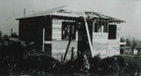
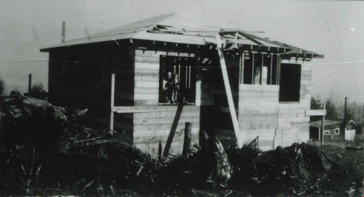
Anderson family home under construction
https://search.heritageburnaby.ca/link/archivedescription37427
- Repository
- City of Burnaby Archives
- Date
- 1946 (date of original), copied 1991
- Collection/Fonds
- Burnaby Historical Society fonds
- Description Level
- Item
- Physical Description
- 1 photograph : b&w ; 2.8 x 5.0 cm print on contact sheet 20.2 x 25.4 cm
- Scope and Content
- Photograph of the Anderson family home at 4151 McGill Street under construction, front view. Madelaine Anderson and Bob Anderson are seen in the window.
- Repository
- City of Burnaby Archives
- Date
- 1946 (date of original), copied 1991
- Collection/Fonds
- Burnaby Historical Society fonds
- Subseries
- Burnaby Image Bank subseries
- Physical Description
- 1 photograph : b&w ; 2.8 x 5.0 cm print on contact sheet 20.2 x 25.4 cm
- Description Level
- Item
- Record No.
- 370-015
- Access Restriction
- No restrictions
- Reproduction Restriction
- No known restrictions
- Accession Number
- BHS1999-03
- Scope and Content
- Photograph of the Anderson family home at 4151 McGill Street under construction, front view. Madelaine Anderson and Bob Anderson are seen in the window.
- Media Type
- Photograph
- Notes
- Title based on contents of photograph
- 1 b&w copy negative accompanying
- Geographic Access
- McGill Street
- Street Address
- 4151 McGill Street
- Historic Neighbourhood
- Vancouver Heights (Historic Neighbourhood)
- Planning Study Area
- Burnaby Heights Area
Images
Application by T.J. Wray for Waiver of the Town Planning and Building Bylaws to Permit the Construction of a Basement Suite at 1545 Gilley Avenue
https://search.heritageburnaby.ca/link/councilreport53266
- Repository
- City of Burnaby Archives
- Report ID
- 69349
- Meeting Date
- 12-Feb-1945
- Format
- Council - Mayor/Councillor/Staff Report
- Collection/Fonds
- City Council and Office of the City Clerk fonds
- Repository
- City of Burnaby Archives
- Report ID
- 69349
- Meeting Date
- 12-Feb-1945
- Format
- Council - Mayor/Councillor/Staff Report
- Collection/Fonds
- City Council and Office of the City Clerk fonds
Documents
Application for Apartment Construction on Block 67, DL 33
https://search.heritageburnaby.ca/link/councilreport47782
- Repository
- City of Burnaby Archives
- Report ID
- 48020
- Meeting Date
- 12-Dec-1949
- Format
- Council - Committee Report
- Collection/Fonds
- City Council and Office of the City Clerk fonds
- Repository
- City of Burnaby Archives
- Report ID
- 48020
- Meeting Date
- 12-Dec-1949
- Format
- Council - Committee Report
- Collection/Fonds
- City Council and Office of the City Clerk fonds