Narrow Results By
Subject
- Adornment - Lapel Pins 1
- Buildings - Residential - Houses 4
- Buildings - Schools 1
- Celebrations 1
- Celebrations - Birthdays 1
- Documentary Artifacts - Postcards 3
- Emergency Measures - Civil Defence 6
- Geographic Features - Roads 1
- Occupations - Teachers 1
- Personal Gear 3
- Personal Gear - Purses 1
- Personal Symbols 1
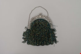
purse
https://search.heritageburnaby.ca/link/museumartifact6428
- Repository
- Burnaby Village Museum
- Accession Code
- BV985.54.1
- Description
- Evening bag, woman's, beaded with irridescent beads, fringe, metal frame features bird design.
- Object History
- Evening bag belonging to Catherine Bertha Rees. She was born in Greenwood, B.C. and came to Burnaby in 1919 with her father, Kingman Nott Rees, and her two brothers. The family settled at 3114 Neville Street, Burnaby (later re-numbered 5674 Neville Street). Catherine attended UBC, graduating with an Arts degree in 1923. She taught French and Latin for 35 years at Burnaby South High School, starting in 1929. Catherine was also a long-time volunteer at BVM.
- Category
- 03. Personal Artifacts
- Classification
- Personal Gear - - Personal Carrying & Storage Gear
- Object Term
- Purse
- Subjects
- Personal Gear - Purses
- Personal Gear
- Historic Neighbourhood
- Alta Vista (Historic Neighbourhood)
- Planning Study Area
- Clinton-Glenwood Area
Images


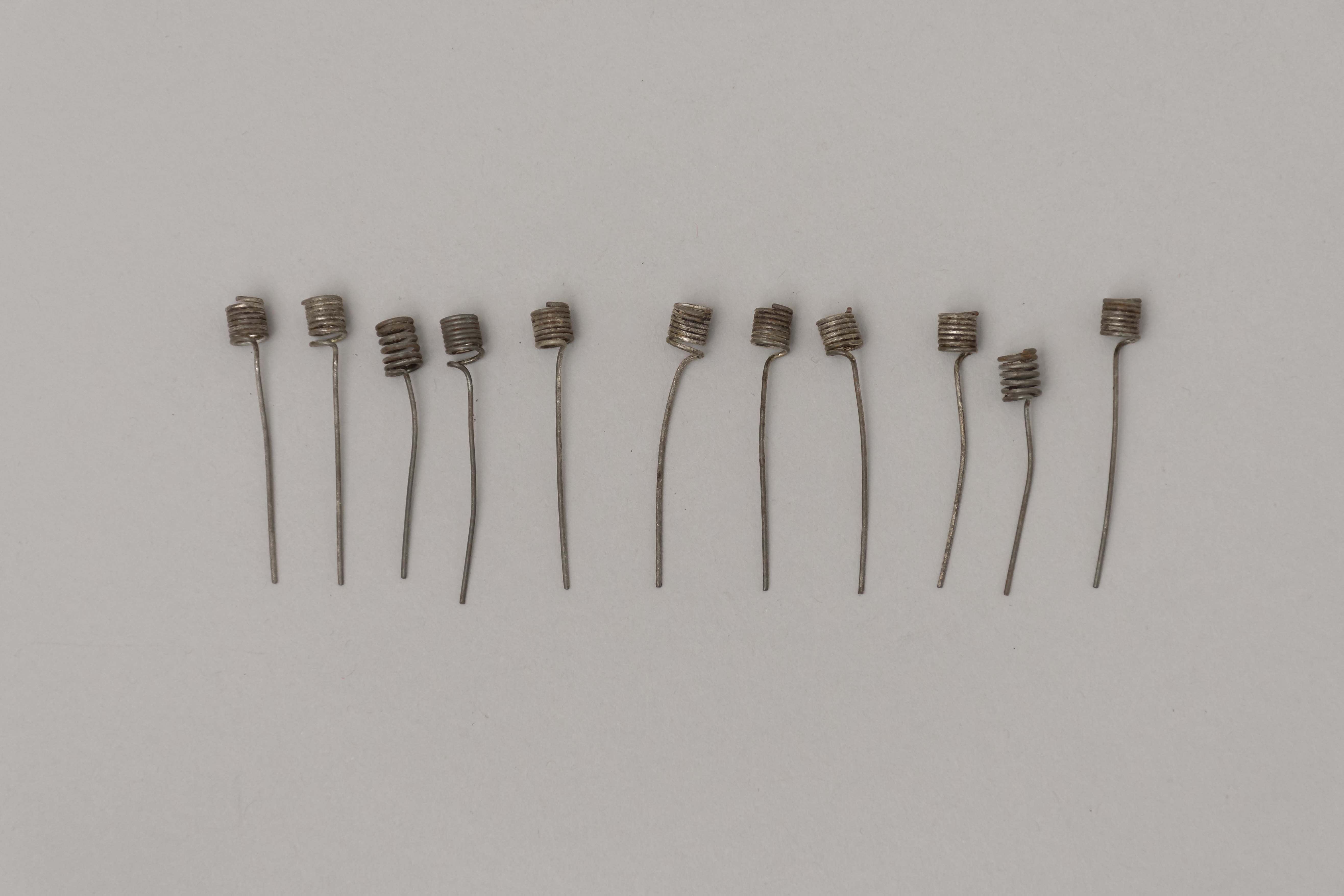
candleholder set
https://search.heritageburnaby.ca/link/museumartifact17410
- Repository
- Burnaby Village Museum
- Accession Code
- HV979.50.37
- Description
- Set of eleven candle holders. They are made of wire, coiled on one end to hold a birthday candle and with approximately one inch of straight wire to insert into the cake.
- Object History
- This item belonged to the owner of Stewart's Cartage & Fuel Supply (1910-1978) on 3870 East Hastings and lived at 3902 Albert Street, Burnaby. He was involved in local politics in Burnaby North, as well as the North Burnaby Board of Trade and the Joint Community Ratepayers Association.
- Category
- 08. Communication Artifacts
- Classification
- Ceremonial Artifacts - - Party Accessories
- Object Term
- Candle, Cake
- Decoration, Cake
- Subjects
- Celebrations - Birthdays
- Celebrations
- Historic Neighbourhood
- Alta Vista (Historic Neighbourhood)
- Planning Study Area
- Clinton-Glenwood Area
Images
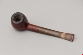
pipe
https://search.heritageburnaby.ca/link/museumartifact18249
- Repository
- Burnaby Village Museum
- Accession Code
- HV978.53.8
- Description
- pipe; black stem; wood bowl; no band; "Made in Canada" and "Medway Deluxe".
- Object History
- This item belonged to Mrs. M. Wight, She lived in Burnaby and was very involved with several community organizations. For an oral history interview with her mother-in-law Edith Wight and the Wight family history please visit Heritage Burnaby: https://search.heritageburnaby.ca/list?q=edith+wight&p=1&ps=25
- Category
- 03. Personal Artifacts
- Classification
- Personal Gear - - Smoking & Recreational Drug Equipment
- Object Term
- Pipe, Smoking
- Subjects
- Personal Gear
- Historic Neighbourhood
- Alta Vista (Historic Neighbourhood)
- Planning Study Area
- Clinton-Glenwood Area
Images

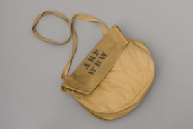
shoulder bag
https://search.heritageburnaby.ca/link/museumartifact39826
- Repository
- Burnaby Village Museum
- Accession Code
- BV999.17.1
- Description
- The shoulder bag is made of yellow canvas. Part of "A.R.P." (Air Raid Precautions) uniform. Probably not official but adapted by the user. "ARP" "WBW" is stencilled in black on the bag flap. The strap is hand-sewn to bag and the flap is secured by two snap-fastener closures
- Object History
- The "A.R.P." bag belonged to Harry Cutress who was a volunteer with the Burnaby Air Raid Precautions.
- Category
- 03. Personal Artifacts
- Classification
- Personal Gear - - Personal Carrying & Storage Gear
- Object Term
- Bag, Carrying
- Historic Neighbourhood
- Alta Vista (Historic Neighbourhood)
- Planning Study Area
- Clinton-Glenwood Area
Images


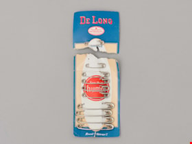
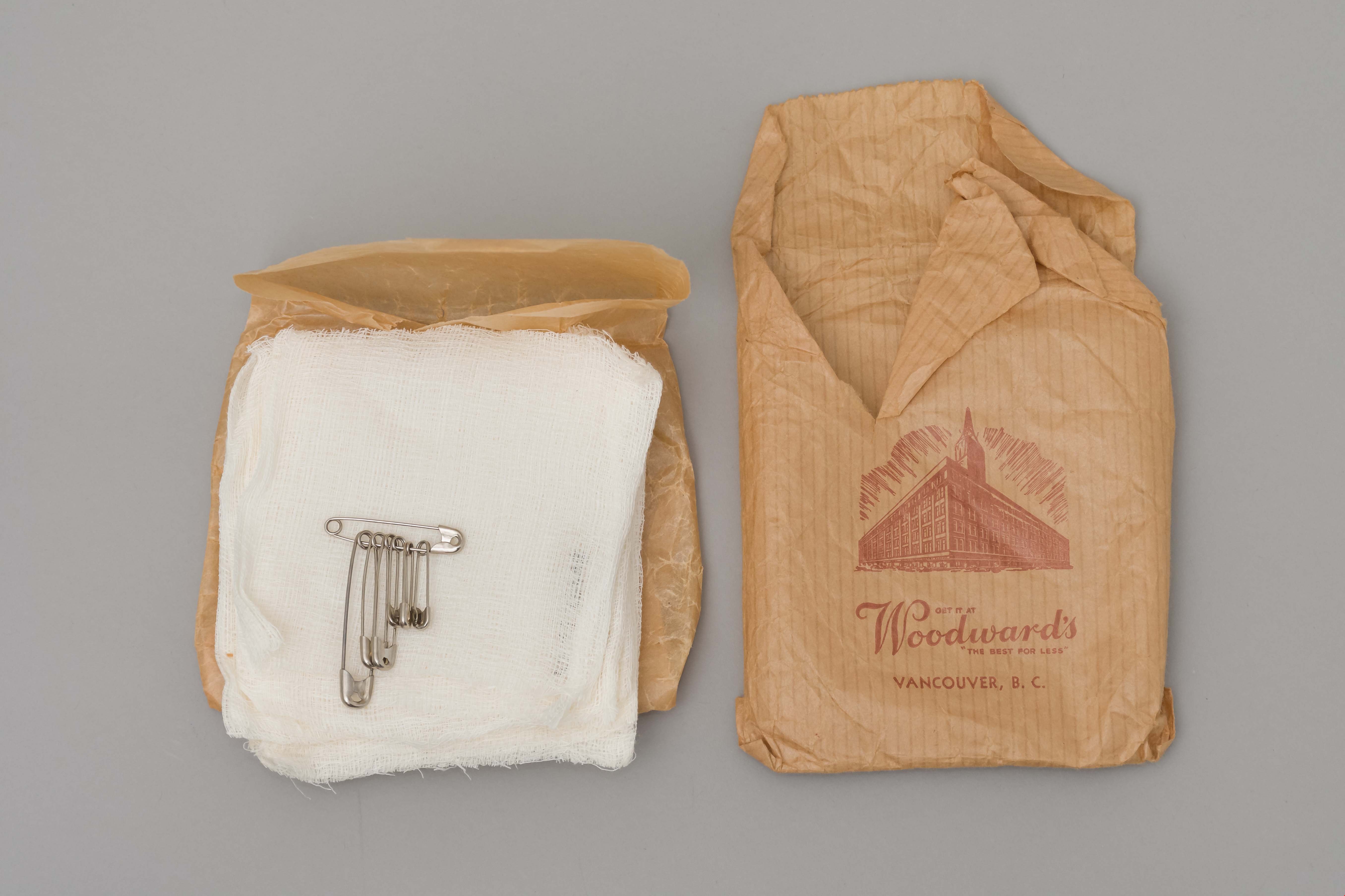
card of pins
https://search.heritageburnaby.ca/link/museumartifact39843
- Repository
- Burnaby Village Museum
- Accession Code
- BV999.17.18
- Description
- Card of safety pins, torn off at top; blue border, ivory border, white oval has red circle in centre and printed in white is "See that Hump", printed at lower edge "Rust? Never!!"; 9 pins on card, 3 sizes; on reverse is list of other products available; torn-off part has red, blue printing "De Long", "Guaranteed by Good Housekeeping" seal; one pin attached; "Assorted"; ivory border corners and top of white oval at torn edge; other products noted on reverse side; c. 1940s
- Object History
- Owner of artifact Harry Charles Cutress was a longtime resident of Burnaby who was a volunteer member of Burnaby ARP.
- Category
- 04.Tools & Equipment for Materials
- Classification
- Textileworking T&E - - Needleworking Equipment
- Object Term
- Pin, Safety
- Historic Neighbourhood
- Alta Vista (Historic Neighbourhood)
- Planning Study Area
- Clinton-Glenwood Area
Images
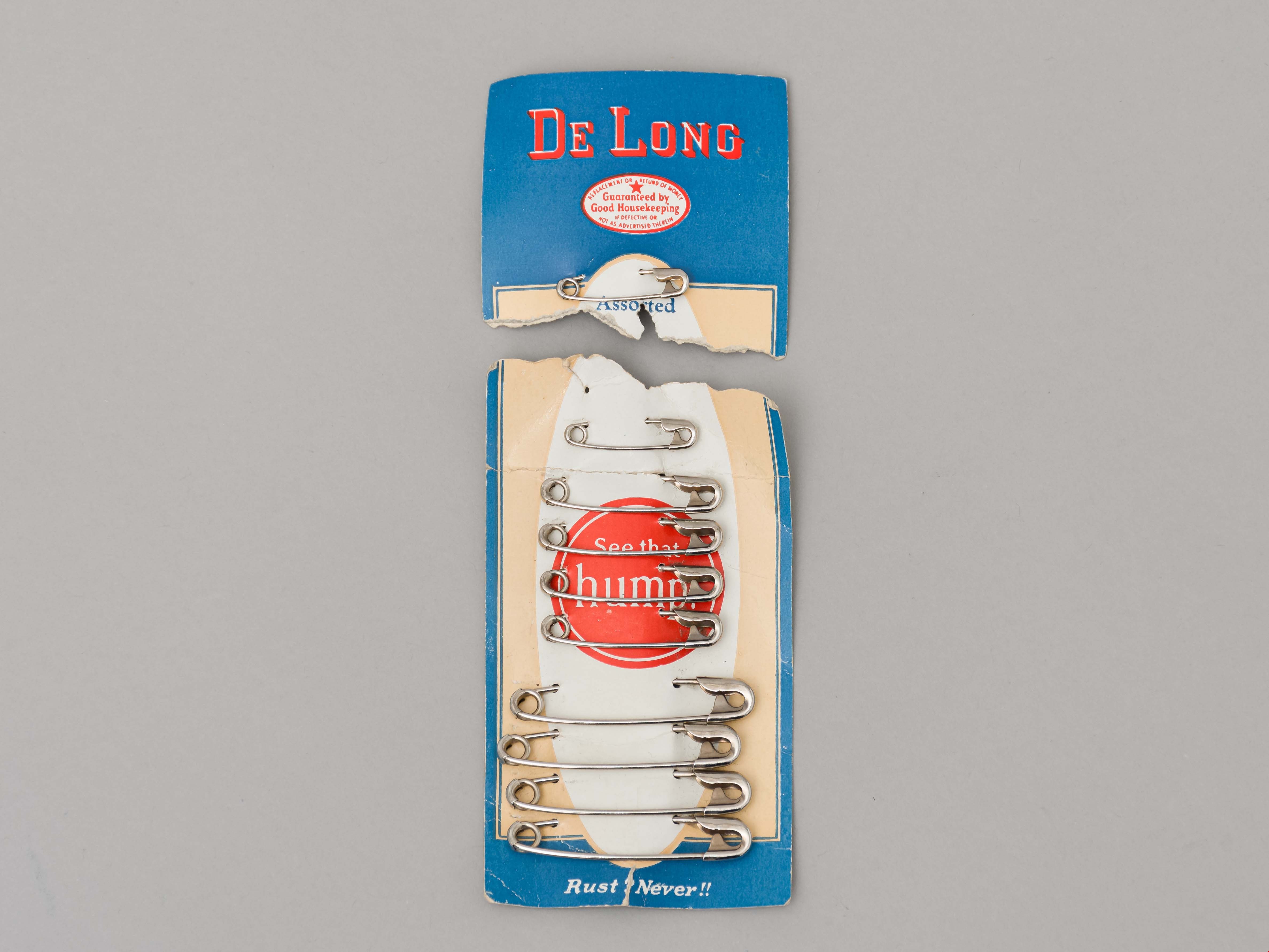
armband
https://search.heritageburnaby.ca/link/museumartifact39844
- Repository
- Burnaby Village Museum
- Accession Code
- BV999.17.19
- Description
- Armband. White canvas with "ARP" stamped in blue. ARP = Air Raid Precautions. WWII Civilian defence group.
- Object History
- The ARP armband belonged to Harry Cutress who was a volunteer with the Burnaby Air Raid Precautions. The Burnaby ARP wore armbands such as these.
- Reference
- See City of Burnaby Archives photograph 028-001 "Burnaby Air Raid Patrol"
- Category
- 03. Personal Artifacts
- Classification
- Clothing - - Clothing Accessories
- Object Term
- Insignia
- Marks/Labels
- "ARP" stamped in blue.
- Historic Neighbourhood
- Alta Vista (Historic Neighbourhood)
- Planning Study Area
- Clinton-Glenwood Area
Images

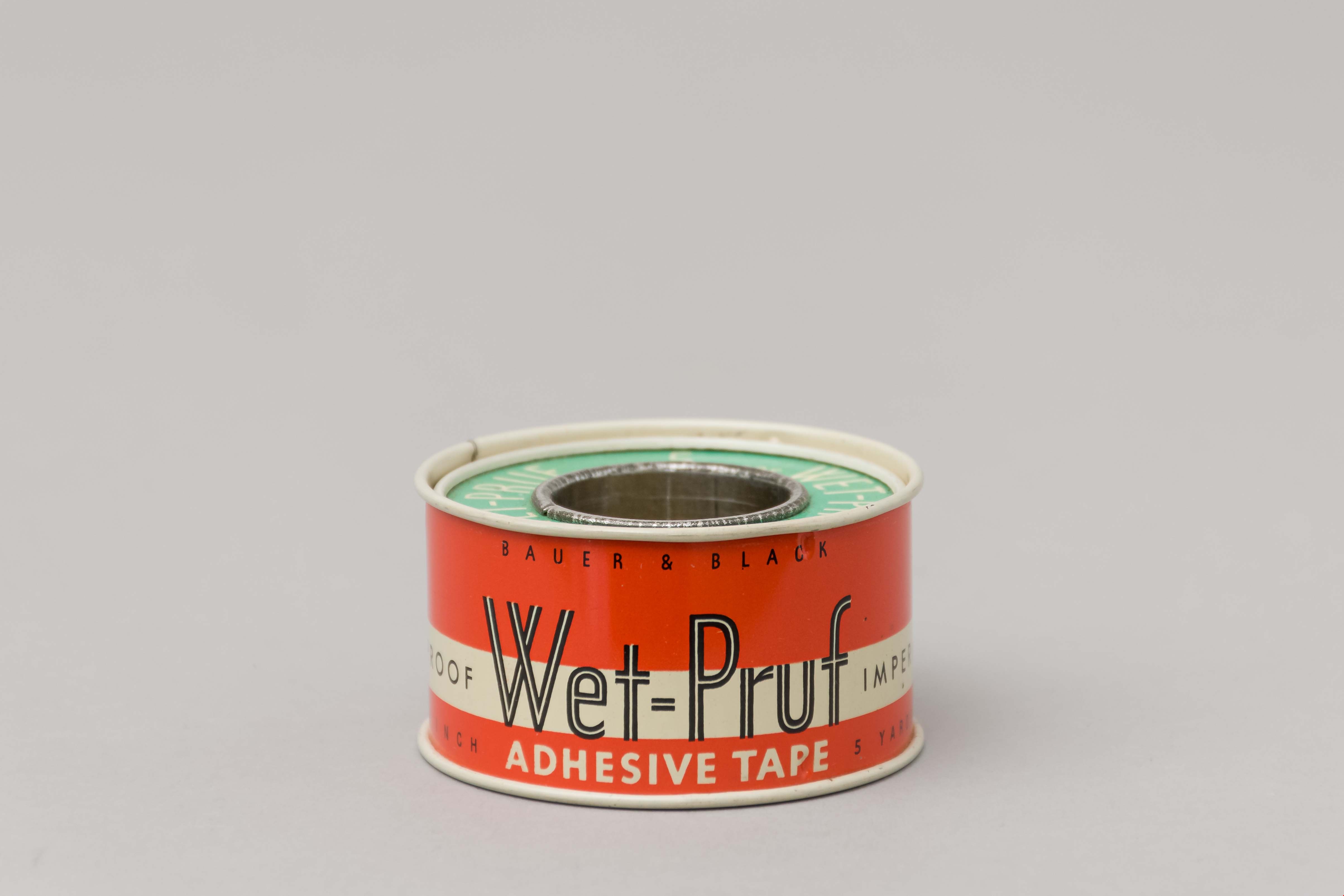
Tape, Medical
https://search.heritageburnaby.ca/link/museumartifact39845
- Repository
- Burnaby Village Museum
- Accession Code
- BV999.17.20
- Description
- Roll of adhesive tape, with cover; top and bottom sides on metal spool have green background, white printing; "Wet-Pruf" printed on opposite sides and between is "Litho'd in U.S.A. 5 Yards", "Adhesive Tape" (repeats other side) ; tape on centre of spool; c. 1940s; cover has orange background, white strip "Bauer & Black" "Waterproof" "Wet=Pruf" "Impermeable" "Pat. No. 2098187" "Printed in U.S.A." "1 Inch" "Adhesive Tape" "5 Yards"; product description and repeat in French printed in white rectangle; "Bauer & Black Limited, Toronto, Canada" "Affiliated with the Kendall Company"
- Object History
- These medical supplies belonged to Harry Cutress who was a volunteer with the Burnaby Air Raid Precautions during World War II.
- Category
- 04.Tools & Equipment for Materials
- Classification
- Medical & Psychological T&E - - Medical Accessories
- Object Term
- Tape, Medical
- Historic Neighbourhood
- Alta Vista (Historic Neighbourhood)
- Planning Study Area
- Clinton-Glenwood Area
Images

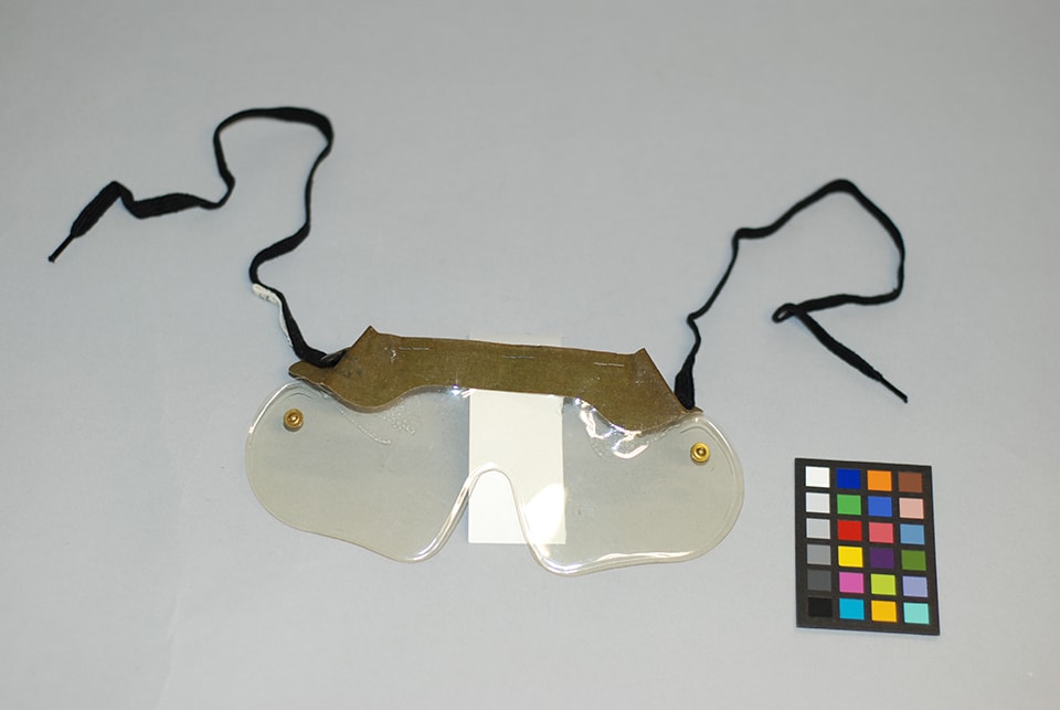
glasses, safety
https://search.heritageburnaby.ca/link/museumartifact39854
- Repository
- Burnaby Village Museum
- Accession Code
- BV999.17.29
- Description
- Eye protector, plastic or celluloid; stapled across top outer edge is a khaki canvas and on inner edge a strip of white wool? tape; a black tie and snap fastener top are attached at each end of khaki strip; the snap fasten- er bottoms are at each end of the plastic; printed on right, reverse side of strip is "1948", "M.W.S. LTD." "Canada"; received in BV999.17.30
- Object History
- Item was used by Harry Charles Cutress who was a volunteer with the Burnaby Air Raid Precautions in South Burnaby during the 1940s.
- Category
- 03. Personal Artifacts
- Classification
- Personal Gear - - Personal Assistive Artifacts
- Object Term
- Eyeglasses
- Historic Neighbourhood
- Alta Vista (Historic Neighbourhood)
- Planning Study Area
- Clinton-Glenwood Area
Images
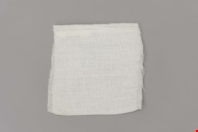
gauze
https://search.heritageburnaby.ca/link/museumartifact39863
- Repository
- Burnaby Village Museum
- Accession Code
- BV999.17.38
- Description
- Gauze pad, received in BV999.17.44
- Object History
- These medical supplies belonged to Harry Cutress who was a volunteer with the Burnaby Air Raid Precautions during World War II.
- Category
- 04.Tools & Equipment for Materials
- Classification
- Medical & Psychological T&E - - Medical Instruments
- Object Term
- Bandage
- Historic Neighbourhood
- Alta Vista (Historic Neighbourhood)
- Planning Study Area
- Clinton-Glenwood Area
Images

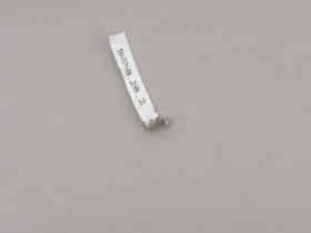
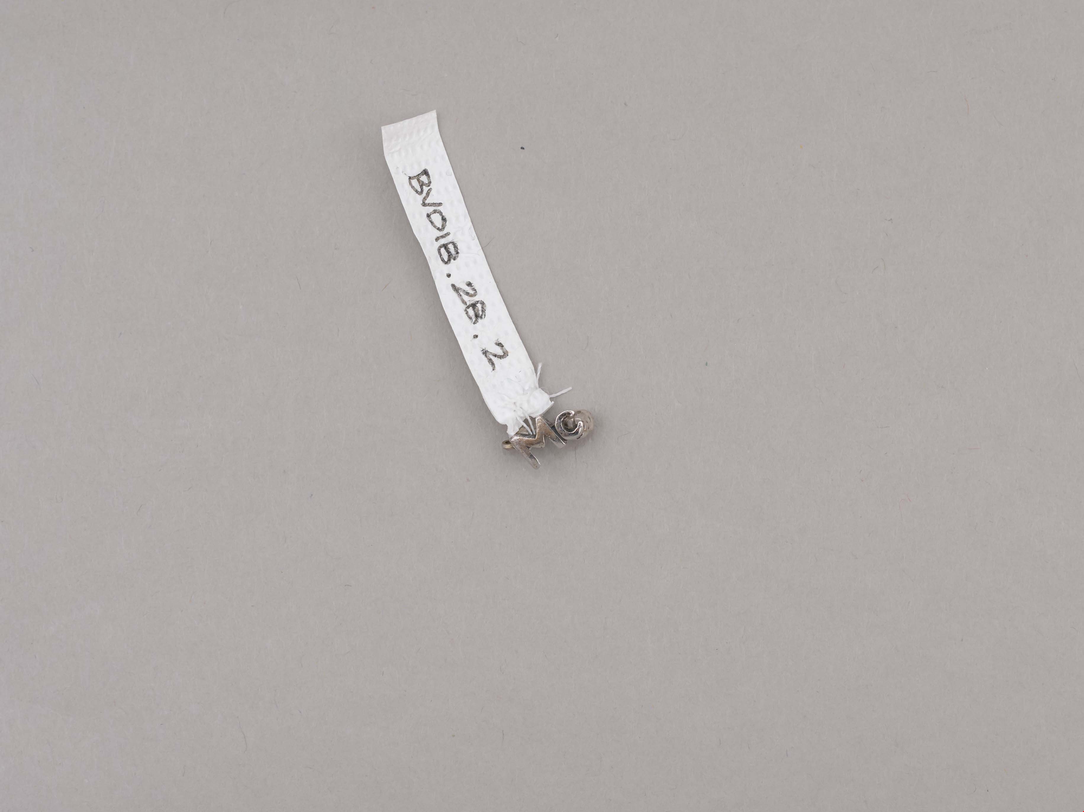
lapel pin
https://search.heritageburnaby.ca/link/museumartifact89261
- Repository
- Burnaby Village Museum
- Accession Code
- BV018.28.2
- Description
- lapel pin; silver "Mc" with locking pin back; letters "Mc" represent McPherson Park Junior Secondary School; ca. 1970.
- Object History
- Donor attended Sussex Avenue School in 1964-65 for grade 5, 1965-66 for grade 6 and 1966-1967 for grade 7.
- Donor attended McPherson Park Junior Secondary School for grades 8-10 from Sept 1967-June 1970. The double academic and athletic crests and the "Mc" pin were received in grade 10.
- Category
- 03. Personal Artifacts
- Subjects
- Adornment - Lapel Pins
- Souvenirs
- Geographic Access
- Rumble Street
- Street Address
- 5455 Rumble Street
- Historic Neighbourhood
- Alta Vista (Historic Neighbourhood)
- Planning Study Area
- Clinton-Glenwood Area
Images
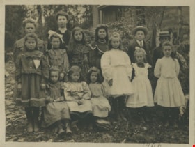
Dundonald School class
https://search.heritageburnaby.ca/link/museumdescription1368
- Repository
- Burnaby Village Museum
- Date
- 1906
- Collection/Fonds
- Burnaby Village Museum Photograph collection
- Description Level
- Item
- Physical Description
- 1 photograph : b&w ; 9 x 12 cm, mounted on card 18 x 23 cm
- Scope and Content
- Photograph of a class of eleven girls and two boys standing outside with their teacher Miss Annie Forrest at the Dundonald School. The students pictured in the photograph are; Maggie Byrne, Annie Thrussell, Nellie Woollard, Gussie Woollard, Elwood Bent and Tommy Brawnlie, Blanche Woollard, [first n…
- Repository
- Burnaby Village Museum
- Collection/Fonds
- Burnaby Village Museum Photograph collection
- Description Level
- Item
- Physical Description
- 1 photograph : b&w ; 9 x 12 cm, mounted on card 18 x 23 cm
- Scope and Content
- Photograph of a class of eleven girls and two boys standing outside with their teacher Miss Annie Forrest at the Dundonald School. The students pictured in the photograph are; Maggie Byrne, Annie Thrussell, Nellie Woollard, Gussie Woollard, Elwood Bent and Tommy Brawnlie, Blanche Woollard, [first name unknown] Brawnlie, Ethel Thrussell, Norah Byrne, Mary Byrne, Bessie Woollard and Alice Woollard. Later called Fraser Arm School, Dundonald School was the fourth school built in Burnaby.
- Subjects
- Occupations - Teachers
- Names
- Dundonald School
- Forrest, Annie Theresa
- Byrne, Margaret "Maggie"
- Thrussell, Annie
- Woollard, Nellie
- Woollard, Gussie
- Bent, Elwood
- Brawnlie, Tommy
- Woollard, Blanche
- Thrussell, Ethel
- Descoteau, Norah Irene Byrne
- Byrne, Mary
- Woollard, Bessie
- Woollard, Alice
- Geographic Access
- Marine Drive
- Street Address
- 5787 Marine Drive
- Accession Code
- BV999.2.58
- Access Restriction
- No restrictions
- Reproduction Restriction
- May be restricted by third party rights
- Date
- 1906
- Media Type
- Photograph
- Historic Neighbourhood
- Fraser Arm (Historic Neighbourhood)
- Planning Study Area
- Clinton-Glenwood Area
- Related Material
- For a copy print from BC archives of the same image, but cropped differently, see HV976.40.3
- Scan Resolution
- 600
- Scan Date
- 08-Jun-09
- Scale
- 100
- Notes
- Title based on contents of photograph
- Note on verso of photograph reads: "Dundonald School. 1906 Left to Right. Maggie Byrne, Annie Thrussell, Nellie Wollard, Gussie Woollard, Elwood Bent, Tommy Brawnlie, Blanche Woollard, Brawnlie, Ethel Thrussell, Nora Byrne, Mary Byrne Bessie Woollard, Alice Woollard."
- Note in pencil on recto of photograph reads: "1906"
Images

![Fred Holdsworth and his wife in front of their house, [1912] thumbnail](/media/hpo/_Data/_BVM_Images/1977/198000120001.jpg?width=280)
Fred Holdsworth and his wife in front of their house
https://search.heritageburnaby.ca/link/museumdescription3029
- Repository
- Burnaby Village Museum
- Date
- [1912]
- Collection/Fonds
- Burnaby Village Museum Photograph collection
- Description Level
- Item
- Physical Description
- 1 photograph : b&w postcard ; 13.9 x 8.5 cm
- Scope and Content
- Photographic postcard of Fred Holdsworth and his wife standing outside their Neville Street Home. The house is two storeys with an attic with windows. The porch is elevated with steep stairs leading to the front door, which is on the second floor. They are both standing with their hands on their hi…
- Repository
- Burnaby Village Museum
- Collection/Fonds
- Burnaby Village Museum Photograph collection
- Description Level
- Item
- Physical Description
- 1 photograph : b&w postcard ; 13.9 x 8.5 cm
- Scope and Content
- Photographic postcard of Fred Holdsworth and his wife standing outside their Neville Street Home. The house is two storeys with an attic with windows. The porch is elevated with steep stairs leading to the front door, which is on the second floor. They are both standing with their hands on their hips. There are variant spellings of "Holdsworth" used in the notes in the accession file. They are "Houldsworth" and "Hallsworth." The 1937 British Columbia directory lists a Fred Houldsworth at 3345 Neville Street, Burnaby. The address was later renumbered 5249 Neville Street.
- Geographic Access
- Neville Street
- Street Address
- 5249 Neville Street
- Accession Code
- HV980.12.1
- Access Restriction
- No restrictions
- Reproduction Restriction
- May be restricted by third party rights
- Date
- [1912]
- Media Type
- Photograph
- Historic Neighbourhood
- Alta-Vista (Historic Neighbourhood)
- Planning Study Area
- Clinton-Glenwood Area
- Scan Resolution
- 600
- Scan Date
- 2023-09-12
- Notes
- Title based on contents of photograph
Images
![Fred Holdsworth and his wife in front of their house, [1912] thumbnail](/media/hpo/_Data/_BVM_Images/1977/198000120001.jpg)
![Holdsworth House on Neville Street, [1912] thumbnail](/media/hpo/_Data/_BVM_Images/1977/198000120002.jpg?width=280)
Holdsworth House on Neville Street
https://search.heritageburnaby.ca/link/museumdescription3030
- Repository
- Burnaby Village Museum
- Date
- [1912]
- Collection/Fonds
- Burnaby Village Museum Photograph collection
- Description Level
- Item
- Physical Description
- 1 photograph : sepia postcard ; 8.8 x 13.8 cm
- Scope and Content
- Photographic postcard of the Holdsworth house on Neville Street. The house is two storeys with an attic with windows. The porch is elevated with steep stairs leading to the front door, which is on the second floor. There is a woman standing in the porch, looking towards the photographer. Another ho…
- Repository
- Burnaby Village Museum
- Collection/Fonds
- Burnaby Village Museum Photograph collection
- Description Level
- Item
- Physical Description
- 1 photograph : sepia postcard ; 8.8 x 13.8 cm
- Scope and Content
- Photographic postcard of the Holdsworth house on Neville Street. The house is two storeys with an attic with windows. The porch is elevated with steep stairs leading to the front door, which is on the second floor. There is a woman standing in the porch, looking towards the photographer. Another house is visible right beside the Holdsworth house. There are variant spellings of "Holdsworth" used in the notes in the accession file. They are "Houldsworth" and "Hallsworth." The 1937 British Columbia directory lists a Fred Houldsworth at 3345 Neville Street, Burnaby. The address was later renumbered 5249 Neville Street.
- Geographic Access
- Neville Street
- Street Address
- 5249 Neville Street
- Accession Code
- HV980.12.2
- Access Restriction
- No restrictions
- Reproduction Restriction
- May be restricted by third party rights
- Date
- [1912]
- Media Type
- Photograph
- Historic Neighbourhood
- Alta-Vista (Historic Neighbourhood)
- Planning Study Area
- Clinton-Glenwood Area
- Scan Resolution
- 600
- Scan Date
- 2023-09-12
- Notes
- Title based on contents of photograph
Images
![Holdsworth House on Neville Street, [1912] thumbnail](/media/hpo/_Data/_BVM_Images/1977/198000120002.jpg)

Neville Street by Royal Oak
https://search.heritageburnaby.ca/link/museumdescription3031
- Repository
- Burnaby Village Museum
- Date
- 1912
- Collection/Fonds
- Burnaby Village Museum Photograph collection
- Description Level
- Item
- Physical Description
- 1 photograph : sepia postcard ; 8.8 x 13.9 cm
- Scope and Content
- Photographic postcard of Neville Street just off Royal Oak Avenue. The street is a dirt road lined with residential buildings on one side and eletric power poles on the other side. The Holdsworth house is seen being constructed on the left. There is scaffolding on the side of the building and a cle…
- Repository
- Burnaby Village Museum
- Collection/Fonds
- Burnaby Village Museum Photograph collection
- Description Level
- Item
- Physical Description
- 1 photograph : sepia postcard ; 8.8 x 13.9 cm
- Scope and Content
- Photographic postcard of Neville Street just off Royal Oak Avenue. The street is a dirt road lined with residential buildings on one side and eletric power poles on the other side. The Holdsworth house is seen being constructed on the left. There is scaffolding on the side of the building and a cleared lot beside the house. here are variant spellings of "Holdsworth" used in the notes in the accession file. They are "Houldsworth" and "Hallsworth." The 1937 British Columbia directory lists a Fred Houldsworth at 3345 Neville Street, Burnaby. The address was later renumbered 5249 Neville Street. An annotation on the back of the postcard reads: "Nevil [sic] Street - 1912 - Just off Royal Oak."
- Subjects
- Buildings - Residential - Houses
- Documentary Artifacts - Postcards
- Geographic Features - Roads
- Geographic Access
- Neville Street
- Royal Oak Avenue
- Accession Code
- HV980.12.3
- Access Restriction
- No restrictions
- Reproduction Restriction
- May be restricted by third party rights
- Date
- 1912
- Media Type
- Photograph
- Historic Neighbourhood
- Alta-Vista (Historic Neighbourhood)
- Planning Study Area
- Clinton-Glenwood Area
- Scan Resolution
- 600
- Scan Date
- 2023-09-12
- Notes
- Title based on contents of photograph
Images


Riverway School site
https://search.heritageburnaby.ca/link/museumdescription11134
- Repository
- Burnaby Village Museum
- Date
- April 16, 1915
- Collection/Fonds
- Ronald G. Scobbie collection
- Description Level
- Item
- Physical Description
- 1 survey plan : blueprint on paper ; 56 x 54 cm
- Scope and Content
- Survey plan of "Riverway School Site / Burnaby Municipality" "Being a 1 acre portion of Lot 159 Group 1, and Lots 30 & 31 of subd. of Bks. 1, 1a, 2, 3, 4 & 5 of Lot 159, Group 1, New Westminster District".
- Repository
- Burnaby Village Museum
- Collection/Fonds
- Ronald G. Scobbie collection
- Description Level
- Item
- Physical Description
- 1 survey plan : blueprint on paper ; 56 x 54 cm
- Material Details
- Scale 40 feet = 1 inch
- Scope and Content
- Survey plan of "Riverway School Site / Burnaby Municipality" "Being a 1 acre portion of Lot 159 Group 1, and Lots 30 & 31 of subd. of Bks. 1, 1a, 2, 3, 4 & 5 of Lot 159, Group 1, New Westminster District".
- Creator
- Geoffrey K. Burnett
- Subjects
- Buildings - Schools
- Names
- Riverway East School
- Responsibility
- Burnett and McGugan B.C. Land Surveyors, New Westminster
- Geographic Access
- Gilley Avenue
- Marine Drive
- Street Address
- 5787 Marine Drive
- Accession Code
- BV003.83.13
- Access Restriction
- No restrictions
- Reproduction Restriction
- No known restrictions
- Date
- April 16, 1915
- Media Type
- Cartographic Material
- Historic Neighbourhood
- Alta Vista (Historic Neighbourhood)
- Planning Study Area
- Clinton-Glenwood Area
- Scan Resolution
- 440
- Scan Date
- 22-Dec-2020
- Scale
- 100
- Notes
- Title based on contents of plan
- Note in black ink on verso of plan reads: "1744" / "Riverway School"
- Oath on plan reads: "I, Geoffrey K. Burnett...and did personally superintend the survey..." "...completed on the 16th day of April 1915"; signed by Geoffrey K. Burnett and notarized by "K.A. Eastman", sworn "...19th day of April 1915"
Zoomable Images

![Riverway East School students, [1922] thumbnail](/media/hpo/_Data/_BVM_Images/1977/198100020001.jpg?width=280)
Riverway East School students
https://search.heritageburnaby.ca/link/museumdescription2
- Repository
- Burnaby Village Museum
- Date
- [1922]
- Collection/Fonds
- Burnaby Village Museum Photograph collection
- Description Level
- Item
- Physical Description
- 1 photograph : b&w ; 12.7 x 17.7 cm
- Scope and Content
- Photograph of students of Riverway East School located in South Burnaby. The children, aged about 7 to 10, are outside in front of the school building. A note in the accession file identify the students as follows: Back row (l to r): Ed Palanski, unidentified boy wearing a tie, Carla Smith, Hillm…
- Repository
- Burnaby Village Museum
- Collection/Fonds
- Burnaby Village Museum Photograph collection
- Description Level
- Item
- Physical Description
- 1 photograph : b&w ; 12.7 x 17.7 cm
- Scope and Content
- Photograph of students of Riverway East School located in South Burnaby. The children, aged about 7 to 10, are outside in front of the school building. A note in the accession file identify the students as follows: Back row (l to r): Ed Palanski, unidentified boy wearing a tie, Carla Smith, Hillman, Patricia Murphy, Pegg Gould, Hilda Murphy, unidentified girl, Pearl Young, Cyril Harcourt, Ed Parslow, and Frank Harcourt; Middle row (l to r): Pauline Whitaker, Nora Lackalau, Ellen Peterson, May Wong, unidentified girl, Dorothy Parslow, Gladys Yates, Sybil Yates, Phyllis Lloyd, unidentified girl, Evelyn Smith, and an unidentified girl; Front row (l to r): Barnard Clissold, Ronald T. Lerriault, Kennedy (last name unknown), Ted Towson, Arthur Yalis, unidentified boy, Sydney Harcourt, unidentified boy, and Jack Towson. An annotation on the back of the photograph reads: "Riverway East 1922."
- Names
- Clissold, Barnard
- Gould, Pegg
- Harcourt, Cyril
- Harcourt, Frank
- Harcourt, Sydney
- Lackalau
- Lerriault, Ronald T.
- Lloyd, Phyllis
- Murphy, Hilda
- Murphy, Patricia
- Palanski, Ed
- Parslow, Dorothy
- Parslow, Ed
- Peterson, Ellen
- Riverway East School
- Smith, Carla
- Smith, Evelyn
- Towson, Jack
- Towson, Ted
- Whitaker, Pauline
- Wong, May
- Yates, Gladys
- Yates, Sybil
- Yalis, Arthur
- Young, Pearl
- Geographic Access
- Marine Drive
- Street Address
- 5787 Marine Drive
- Accession Code
- HV981.2.1
- Access Restriction
- No restrictions
- Reproduction Restriction
- May be restricted by third party rights
- Date
- [1922]
- Media Type
- Photograph
- Historic Neighbourhood
- Alta-Vista (Historic Neighbourhood)
- Planning Study Area
- Clinton-Glenwood Area
- Scan Resolution
- 600
- Scan Date
- 2023-09-12
- Notes
- Title based on contents of photograph
Images
![Riverway East School students, [1922] thumbnail](/media/hpo/_Data/_BVM_Images/1977/198100020001.jpg)

Municipality of Burnaby - Volume XV, Volume XVI, Volume XVII, Volume XVIII
https://search.heritageburnaby.ca/link/museumdescription8685
- Repository
- Burnaby Village Museum
- Date
- May 1927
- Collection/Fonds
- Burnaby Village Museum Map collection
- Description Level
- File
- Physical Description
- 4 plans on 4 sheets : col. lithographic prints ; 63.5 x 53.5 cm folded to 53 x 31.5 cm
- Scope and Content
- File consists of four pages of plans removed from a bound book containing a series of fire insurance plans of the Municipality of Burnaby. Plan "1531" is part of "GREATER VANCOUVER B.C. / VOLUME XV / Municipality of Burnaby / May 1927" and covers District Lots: 116 and 117. Key Plan "C" is part of …
- Repository
- Burnaby Village Museum
- Collection/Fonds
- Burnaby Village Museum Map collection
- Description Level
- File
- Physical Description
- 4 plans on 4 sheets : col. lithographic prints ; 63.5 x 53.5 cm folded to 53 x 31.5 cm
- Material Details
- Scale [1:600] and [1:1200]
- Scope and Content
- File consists of four pages of plans removed from a bound book containing a series of fire insurance plans of the Municipality of Burnaby. Plan "1531" is part of "GREATER VANCOUVER B.C. / VOLUME XV / Municipality of Burnaby / May 1927" and covers District Lots: 116 and 117. Key Plan "C" is part of "GREATER VANCOUVER B.C. / VOLUME XVI / Municipality of Burnaby / May 1927" and covers plans 1623 to 1651 and District Lots: 1 and 2; 4; 6; 8; 10 to 14; 25; 27; 40; 56 to 58; 88 and 89. Plan "1738" is part of "GREATER VANCOUVER B.C. / VOLUME XVII / Municipality of Burnaby / May 1927" and covers District Lots: 34 and 35. Key plan "G" is part of "GREATER VANCOUVER B.C. / VOLUME XVIII / Municipality of Burnaby / May 1927" and covers plans: 1801 to 1813; 1823; 1824; 1833 to 1838; 1841 to 1853 and District Lots: 32; 93; 94; 97 to 99; 149; 150; 152; 155 to 159; 161 to 164.
- Responsibility
- British Columbia Underwriters' Association
- Accession Code
- HV972.111.7
- Access Restriction
- No restrictions
- Reproduction Restriction
- May be restricted by third party rights
- Date
- May 1927
- Media Type
- Cartographic Material
- Historic Neighbourhood
- Central Park (Historic Neighbourhood)
- Fraser Arm (Historic Neighbourhood)
- Alta Vista (Historic Neighbourhood)
- Broadview (Historic Neighbourhood)
- Vancouver Heights (Historic Neighbourhood)
- Burquitlam (Historic Neighbourhood)
- East Burnaby (Historic Neighbourhood)
- Edmonds (Historic Neighbourhood)
- Lozells (Historic Neighbourhood)
- Planning Study Area
- Clinton-Glenwood Area
- Marlborough Area
- Maywood Area
- Windsor Area
- Big Bend Area
- Garden Village Area
- Willingdon Heights Area
- West Central Valley Area
- Cariboo-Armstrong Area
- Lyndhurst Area
- Cameron Area
- Lake City Area
- Edmonds Area
- Second Street Area
- Sperling-Broadway Area
- Lakeview-Mayfield Area
- Scan Resolution
- 400
- Scan Date
- 2021-11-18
- Notes
- Title based on content of plans
- See also BV987.1.70d for revised versions of plans
- Scale is measured 1 inch = 500 feet
Zoomable Images

Municipality of Burnaby - Volume XV, Volume XVI, Volume XVII, Volume XVIII, May 1927
Zoom into Image

Municipality of Burnaby- Volume XV and Volume XVIII
https://search.heritageburnaby.ca/link/museumdescription8686
- Repository
- Burnaby Village Museum
- Date
- May 1927
- Collection/Fonds
- Burnaby Village Museum Map collection
- Description Level
- File
- Physical Description
- 4 plans on 4 sheets : col. lithographic prints ; 63.5 x 53.5 cm folded to 53 x 31.5 cm
- Scope and Content
- File consists of four pages of plans removed from a bound book containing a series of fire insurance plans of the Municipality of Burnaby. Plan "1520" is part of "GREATER VANCOUVER B.C. / VOLUME XV / Municipality of Burnaby / May 1927" and covers District Lots: 121 and 187. Plann "1521" is part of …
- Repository
- Burnaby Village Museum
- Collection/Fonds
- Burnaby Village Museum Map collection
- Description Level
- File
- Physical Description
- 4 plans on 4 sheets : col. lithographic prints ; 63.5 x 53.5 cm folded to 53 x 31.5 cm
- Material Details
- Scale [1:600] and [1:1200]
- Scope and Content
- File consists of four pages of plans removed from a bound book containing a series of fire insurance plans of the Municipality of Burnaby. Plan "1520" is part of "GREATER VANCOUVER B.C. / VOLUME XV / Municipality of Burnaby / May 1927" and covers District Lots: 121 and 187. Plann "1521" is part of "GREATER VANCOUVER B.C. / VOLUME XV / Municipality of Burnaby / May 1927" and covers District Lots: 121 and 187. Key plan "H" reads: "GREATER VANCOUVER B.C. / VOLUME XVIII / Surveyed _ May 1927 / MUNICIPALITY OF / BURNABY" and covers plans: 1813 to 1822; 1824 to 1832; 1839; 1840; 1853 to 1865 and District Lots: 28; 30; 53; 90 to 93; 95 to 97; 155a; 155b; 155c; 159; 160; 171 to 173. Plan "1801" is part of "GREATER VANCOUVER B.C. / VOLUME XVIII / Municipality of Burnaby / May 1927" and covers District Lot 153.
- Responsibility
- British Columbia Underwriters' Association
- Accession Code
- HV972.111.8
- Access Restriction
- No restrictions
- Reproduction Restriction
- May be restricted by third party rights
- Date
- May 1927
- Media Type
- Cartographic Material
- Historic Neighbourhood
- Fraser Arm (Historic Neighbourhood)
- Vancouver Heights (Historic Neighbourhood)
- East Burnaby (Historic Neighbourhood)
- Edmonds (Historic Neighbourhood)
- Planning Study Area
- Marlborough Area
- Kingsway-Beresford Area
- Windsor Area
- Big Bend Area
- Clinton-Glenwood Area
- Burnaby Heights Area
- Edmonds Area
- Stride Avenue Area
- Scan Resolution
- 400
- Scan Date
- 2021-11-18
- Notes
- Title based on content of plans
- See also BV987.1.70d for revised versions of plans
- Scale is measured 1 inch = 500 feet
Zoomable Images

![England family home on Royal Oak Avenue, [between 1927 and 1930] (date of original) , copied 2020 thumbnail](/media/hpo/_Data/_BVM_Images/2020/2020_0009_0002_001.jpg?width=280)
England family home on Royal Oak Avenue
https://search.heritageburnaby.ca/link/museumdescription12230
- Repository
- Burnaby Village Museum
- Date
- [between 1927 and 1930] (date of original) , copied 2020
- Collection/Fonds
- Mary England fonds
- Description Level
- Item
- Physical Description
- 1 photograph (tiff) : b&w ; 600 dpi
- Scope and Content
- Photograph of a Craftsman style house located at 1906 Royal Oak Avenue near Victory Street in Burnaby (address was changed to 7353 Royal Oak Aveue after 1958). The house was built in 1914 and was the home of Alfred Henry and Mary England (nee Gooding). Alfred H. England died suddenly in 1917. Mary…
- Repository
- Burnaby Village Museum
- Collection/Fonds
- Mary England fonds
- Description Level
- Item
- Physical Description
- 1 photograph (tiff) : b&w ; 600 dpi
- Scope and Content
- Photograph of a Craftsman style house located at 1906 Royal Oak Avenue near Victory Street in Burnaby (address was changed to 7353 Royal Oak Aveue after 1958). The house was built in 1914 and was the home of Alfred Henry and Mary England (nee Gooding). Alfred H. England died suddenly in 1917. Mary England continued to live in the house before settling in a house that she had built on Griffiths Avenue in 1930.
- Subjects
- Buildings - Residential - Houses
- Geographic Access
- Royal Oak Avenue
- Victory Street
- Accession Code
- BV020.9.2
- Access Restriction
- No restrictions
- Reproduction Restriction
- May be restricted by third party rights
- Date
- [between 1927 and 1930] (date of original) , copied 2020
- Media Type
- Photograph
- Historic Neighbourhood
- Central Park (Historic Neighbourhood)
- Alta Vista (Historic Neighbourhood)
- Planning Study Area
- Clinton-Glenwood Area
- Scan Resolution
- 600
- Scan Date
- 12-Feb-20
- Scale
- 100
- Notes
- Title based on contents of photograph
Images
![England family home on Royal Oak Avenue, [between 1927 and 1930] (date of original) , copied 2020 thumbnail](/media/hpo/_Data/_BVM_Images/2020/2020_0009_0002_001.jpg)