Narrow Results By
Subject
- Advertising Medium - Signs and Signboards 2
- Agriculture - Crops 1
- Agriculture - Farms 1
- Arts - Sculptures 1
- Building Components 1
- Buildings - Residential 1
- Buildings - Residential - Apartments 1
- Ceremonies - Awards 1
- Corporations - Private Corporations 1
- Documentary Artifacts - Architectural Drawings 1
- Documentary Artifacts - Maps 2
- Geographic Features - Parks 1
Creator
- Bartel, Mario 5
- Burnaby (B.C.). Planning Department 1
- Burnaby Planning Department 1
- Burnaby Tourism Strategy Advisory Committee 1
- Cheung, Nakita 1
- City of Burnaby 1
- Daon Development Corporation 1
- Medig, Kari 1
- Norman Hotson Architects 1
- Sixta, Gerhard 1
- Thomson, A.R. 1
- Traffic and Transportation Committee 1
Tenders of Deer Lake Mill, Enterprise Saw and Planning Mill, Royal City Planning Mill, Small and Bucklin and Brunette Mills be Accepted
https://search.heritageburnaby.ca/link/councilreport78001
- Repository
- City of Burnaby Archives
- Report ID
- 82177
- Meeting Date
- 10-Nov-1910
- Format
- Council - Committee Report
- Collection/Fonds
- City Council and Office of the City Clerk fonds
- Repository
- City of Burnaby Archives
- Report ID
- 82177
- Meeting Date
- 10-Nov-1910
- Format
- Council - Committee Report
- Collection/Fonds
- City Council and Office of the City Clerk fonds
Documents
Burnaby Metrotown : a development plan
https://search.heritageburnaby.ca/link/museumlibrary4951
- Repository
- Burnaby Village Museum
- Collection
- Special Collection
- Material Type
- Book
- Accession Code
- BV006.24.38
- Call Number
- 307.1 BUR
- Place of Publication
- [Burnaby, B.C.]
- Publisher
- Burnaby Planning Dept.
- Publication Date
- 1977
- Printer
- College Printers Ltd.
- Physical Description
- 83 p. : ill. : 22 x 28 cm.
- Inscription
- "Page 67 Land purchase" [Handwritten in blue ink on page 3]
- Library Subject (LOC)
- City planning--British Columbia
- City planning--British Columbia--Burnaby
- Central business districts--British Columbia--Vancouver Region
- Vancouver (B.C.)--Suburbs and environs
- Burnaby, B.C.
- Metrotown (Burnaby, B.C.)
- Community development, Urban
- Central business districts
- Subjects
- Planning - City Planning
Burnaby trail study
https://search.heritageburnaby.ca/link/museumlibrary5479
- Repository
- Burnaby Village Museum
- Collection
- Reference Collection
- Material Type
- Book
- Call Number
- 711.558 BUR
- Place of Publication
- Burnaby
- Publisher
- Planning Dept.
- Publication Date
- 1980
- Physical Description
- 105 p. : ill. ; 36 cm.
- Library Subject (LOC)
- City planning--British Columbia
- Trails--British Columbia--Burnaby
- City planning--British Columbia--Burnaby
- Parks--British Columbia--Burnaby
- Subjects
- Planning - City Planning
- Notes
- Document inserted in cover: "Re: access, trail development Burnaby foreshore areas, acting municipal manager's recommendation", July 06, 1988, Item 29, Manager's report no. 47, council meeting: 1988/07/11.
- Oversized book.
A development programme for Burnaby Lake Regional Park
https://search.heritageburnaby.ca/link/museumlibrary5165
- Repository
- Burnaby Village Museum
- Author
- Burnaby Planning Department
- Publication Date
- 1975
- Call Number
- 333.78 BUR copy 1
- Repository
- Burnaby Village Museum
- Collection
- Reference Collection
- Material Type
- Book
- Call Number
- 333.78 BUR copy 1
- Author
- Burnaby Planning Department
- Place of Publication
- Burnaby, B.C.
- Publisher
- Planning Dept.
- Publication Date
- 1975
- Physical Description
- 63, xi p. : ill. ; 22 x 35 cm
- Library Subject (LOC)
- Parks--British Columbia--Burnaby
- City planning--British Columbia--Burnaby
- Burnaby Lake Regional Park (B.C.)
- Subjects
- Planning - City Planning
- Notes
- Includes bibliographical references.
- 2 copies held ; copy 1

Burnaby Heights "panhandling meter"
https://search.heritageburnaby.ca/link/archivedescription97994
- Repository
- City of Burnaby Archives
- Date
- [2000]
- Collection/Fonds
- Burnaby NewsLeader photograph collection
- Description Level
- File
- Physical Description
- 2 photographs (tiff) : col.
- Scope and Content
- File contains photographs of Mark, a panhandler, on Hastings Street by a "panhandling meter" installed by the City of Burnaby. The meter reads: "This is not a parking meter / Spare change for social change."
- Repository
- City of Burnaby Archives
- Date
- [2000]
- Collection/Fonds
- Burnaby NewsLeader photograph collection
- Physical Description
- 2 photographs (tiff) : col.
- Description Level
- File
- Record No.
- 535-3098
- Access Restriction
- No restrictions
- Reproduction Restriction
- No restrictions
- Accession Number
- 2018-12
- Scope and Content
- File contains photographs of Mark, a panhandler, on Hastings Street by a "panhandling meter" installed by the City of Burnaby. The meter reads: "This is not a parking meter / Spare change for social change."
- Media Type
- Photograph
- Photographer
- Bartel, Mario
- Notes
- Title based on caption
- Collected by editorial for use in a February 2000 issue of the Burnaby NewsLeader
- Caption from metadata for 535-3098-1: "Mark says he panhandles along Hastings St. when he's hungry and can't afford food. He says the new meters haven't affected his take."
- Caption from metadata for 535-3098-2: "The new spare change meters haven't disuaded panhandlers, like Mark, from setting up shop along Hastings St. He says he panhandles when he needs money for food."
- Geographic Access
- Hastings Street
- Carleton Avenue
- Historic Neighbourhood
- Vancouver Heights (Historic Neighbourhood)
- Planning Study Area
- Burnaby Heights Area
Images

Burnaby Metrotown : a project
https://search.heritageburnaby.ca/link/museumlibrary1156
- Repository
- Burnaby Village Museum
- Author
- Daon Development Corporation
- Publication Date
- 1984
- Call Number
- 971.1 MET
- Repository
- Burnaby Village Museum
- Collection
- Reference Collection
- Material Type
- Textual Record
- Call Number
- 971.1 MET
- Author
- Daon Development Corporation
- Place of Publication
- [S.l.]
- Publisher
- Daon Development Corporation
- Publication Date
- 1984
- Physical Description
- 1 v. (no paging) : ill. (some col.) ; 30 cm.
- Inscription
- "Colin - museum director / For you to do with as you wish - / discard or retain for historical reasons. / J. Plesha / Aug 1990", handwritten in pencil and ink on a note inserted in the pocket on the inside of the front cover.
- Library Subject (LOC)
- City planning--British Columbia--Burnaby
- Community development, Urban
- Central business districts--British Columbia--Vancouver Region
- Subjects
- Planning - City Planning
![Burnaby Mountain community consultation, [2000] thumbnail](/media/hpo/_Data/_Archives_Images/_Unrestricted/535/535-2539.jpg?width=280)
Burnaby Mountain community consultation
https://search.heritageburnaby.ca/link/archivedescription97007
- Repository
- City of Burnaby Archives
- Date
- [2000]
- Collection/Fonds
- Burnaby NewsLeader photograph collection
- Description Level
- Item
- Physical Description
- 1 photograph (tiff) : col.
- Scope and Content
- Photograph of Burnaby resident John Unger filing out a comment form at a open house and community consultation event about development plans for Burnaby Mountain, held at the Copeland Arena. Posters outlining the development plans are visible behind Unger.
- Repository
- City of Burnaby Archives
- Date
- [2000]
- Collection/Fonds
- Burnaby NewsLeader photograph collection
- Physical Description
- 1 photograph (tiff) : col.
- Description Level
- Item
- Record No.
- 535-2539
- Access Restriction
- No restrictions
- Reproduction Restriction
- No restrictions
- Accession Number
- 2018-12
- Scope and Content
- Photograph of Burnaby resident John Unger filing out a comment form at a open house and community consultation event about development plans for Burnaby Mountain, held at the Copeland Arena. Posters outlining the development plans are visible behind Unger.
- Media Type
- Photograph
- Photographer
- Bartel, Mario
- Notes
- Title based on caption
- Collected by editorial for use in a July 2000 issue of the Burnaby NewsLeader
- Caption from metadata: "Burnaby residents, like John Unger, take the opportunity to fill out comment forms at an open house at Copeland Arena to unveil development plans for Burnaby Mountain."
- Geographic Access
- Burnaby Lake Sports Complex
- Kensington Avenue
- Street Address
- 3676 Kensington Avenue
- Historic Neighbourhood
- Burnaby Lake (Historic Neighbourhood)
- Planning Study Area
- Ardingley-Sprott Area
Images
![Burnaby Mountain community consultation, [2000] thumbnail](/media/hpo/_Data/_Archives_Images/_Unrestricted/535/535-2539.jpg)
Burnaby tourism strategy
https://search.heritageburnaby.ca/link/museumlibrary7603
- Repository
- Burnaby Village Museum
- Collection
- Reference Collection
- Material Type
- Book
- Call Number
- 338.4791 BUR
- Place of Publication
- Burnaby, BC
- Publisher
- City of Burnaby
- Publication Date
- 1994
- Physical Description
- 82 p. : ill. ; 29 cm.
- Library Subject (LOC)
- City planning--British Columbia--Burnaby
- Subjects
- Planning - City Planning
- Notes
- "Produced by the Burnaby Tourism Strategy Advisory Committee Membership outlined in Appendix C, Project manager, Phil Sanderson, Economic Development Office Economic Development Office, City of Burnaby. Consultants: James MacGregor (Lavalin Corp.) in collaboration with Addison Travel Marketing, G.S. Sue Henderson & Associates."
The Burnaby transportation plan
https://search.heritageburnaby.ca/link/museumlibrary1237
- Repository
- Burnaby Village Museum
- Collection
- Reference Collection
- Material Type
- Textual Record
- Call Number
- 711.7 BUR
- Place of Publication
- Burnaby
- Publisher
- City of Burnaby
- Publication Date
- 1995
- Physical Description
- 132 [178] p.: ill. ; 30 cm.
- Library Subject (LOC)
- Urban Transportation--British Columbia--Burnaby
- City planning--British Columbia--Burnaby
- Subjects
- Planning - City Planning
![Caila Anderson with traffic signs, [2000] thumbnail](/media/hpo/_Data/_Archives_Images/_Unrestricted/535/535-2547.jpg?width=280)
Caila Anderson with traffic signs
https://search.heritageburnaby.ca/link/archivedescription97015
- Repository
- City of Burnaby Archives
- Date
- [2000]
- Collection/Fonds
- Burnaby NewsLeader photograph collection
- Description Level
- Item
- Physical Description
- 1 photograph (tiff) : col.
- Scope and Content
- Photograph of Caila Anderson, an employee of International SPFX, standing with her arms crossed next to two traffic signs on Greenwood Street.
- Repository
- City of Burnaby Archives
- Date
- [2000]
- Collection/Fonds
- Burnaby NewsLeader photograph collection
- Physical Description
- 1 photograph (tiff) : col.
- Description Level
- Item
- Record No.
- 535-2547
- Access Restriction
- No restrictions
- Reproduction Restriction
- No restrictions
- Accession Number
- 2018-12
- Scope and Content
- Photograph of Caila Anderson, an employee of International SPFX, standing with her arms crossed next to two traffic signs on Greenwood Street.
- Subjects
- Planning - City Planning
- Advertising Medium - Signs and Signboards
- Geographic Features - Roads
- Media Type
- Photograph
- Photographer
- Bartel, Mario
- Notes
- Title based on caption
- Collected by editorial for use in a July 2000 issue of the Burnaby NewsLeader
- Caption from metadata: "Caila Anderson, of International SPFX, says new traffic regulations on Greenwood St. have made it really inconvenient for employees at the movie special effects company to get to and from their production offices. Residents on the street say the regulations haven't gone far enough."
- Geographic Access
- Greenwood Street
- Historic Neighbourhood
- Lozells (Historic Neighbourhood)
- Planning Study Area
- Government Road Area
Images
![Caila Anderson with traffic signs, [2000] thumbnail](/media/hpo/_Data/_Archives_Images/_Unrestricted/535/535-2547.jpg)
Glass Sculpture
https://search.heritageburnaby.ca/link/museumartifact90817
- Repository
- Burnaby Village Museum
- Accession Code
- BV020.40.8
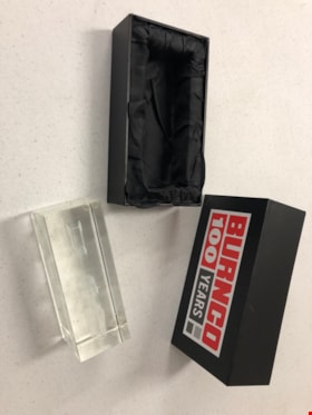
- Description
- Glass rectangular prism with 3D etching depicting heavy duty trucks. Each corner of the bottom of the sculpture has a small pad. The sculpture has a branded black box for safe carrying. The box is in two parts. The exterior of both parts is covered in a black vinyl wrap, and polyester satin in the inside. The inside of each box is inset to fit on half of the sculpture. The top half of the box has a "Burnco 100 Years" logo in red, gray, white and black.
- Object History
- The Burnco company was established in Calgary in 1912 as a rock and aggregate and concrete supply company. This presentation piece was presented to the City of Burnaby on the establishment of its new Burnaby based plant in the Big Bend area in 2004.
- Category
- 08. Communication Artifacts
- Classification
- Ceremonial Artifacts
- Object Term
- Sculpture
- Marks/Labels
- BURNCO 100 YEARS
- Colour
- Red
- Gray
- White
- Black
- Subjects
- Arts - Sculptures
- Corporations - Private Corporations
- Industries
- Natural Resources - Mineral Resources
- Planning - City Planning
- Historic Neighbourhood
- Fraser Arm (Historic Neighbourhood)
- Planning Study Area
- Big Bend Area
Images


Ink
https://search.heritageburnaby.ca/link/museumartifact90812
- Repository
- Burnaby Village Museum
- Accession Code
- BV020.40.3
- Description
- Glass bottle of black ink, with a plastic textured lid. The front label is yellow with a gold border, and a blue band along the bottom of the label. It has a black ink stain down the front. The back label is smaller and lighter colour with a yellow stain that reaches to the middle of the label.
- Object History
- This ink came along with a lettering guide used in the City of Burnaby's Planning Department, in the late 1950s. See also BV020.40.2
- Classification
- Written Communication T&E - - Writing Accessories
- Object Term
- Ink
- Marks/Labels
- Chin-Chin waterproof Liquid PearlInk / Sole Canadian Distributors / Made in Germany / Protect from Freezing
- Colour
- Black
- Yellow
- Blue
- Measurements
- 30cm high
- Maker
- PearlInk
- Subjects
- Documentary Artifacts - Architectural Drawings
- Government - Local Government
- Land - Land Surveying
- Occupations - Civic Workers
- Planning - City Planning
- Historic Neighbourhood
- Burnaby Lake (Historic Neighbourhood)
- Planning Study Area
- Douglas-Gilpin Area
Images

The livable region 1976/1986 : proposals to manage the growth of Greater Vancouver
https://search.heritageburnaby.ca/link/museumlibrary5156
- Repository
- Burnaby Village Museum
- Collection
- Reference Collection
- Material Type
- Book
- Call Number
- 710.09 LIV COPY 1
- Place of Publication
- Vancouver
- Publisher
- Greater Vancouver Regional District
- Publication Date
- 1975
- Physical Description
- 50 p. : ill., maps ; 22 x 30 cm.
- Library Subject (LOC)
- City planning--British Columbia--Vancouver Metropolitan Area
- Regional planning--British Columbia--Vancouver Metropolitan Area
- Subjects
- Planning - City Planning
- Notes
- 3 copies held, copy 1.
![Margaret Manifold and the Community Asset Mapping System, [2005] thumbnail](/media/hpo/_Data/_Archives_Images/_Unrestricted/535/535-1927-1.jpg?width=280)
Margaret Manifold and the Community Asset Mapping System
https://search.heritageburnaby.ca/link/archivedescription96243
- Repository
- City of Burnaby Archives
- Date
- [2005]
- Collection/Fonds
- Burnaby NewsLeader photograph collection
- Description Level
- File
- Physical Description
- 2 photographs (tiff) : col.
- Scope and Content
- File contains photographs of Margaret Manifold, of the City of Burnaby Planning Department, posing with print-outs of maps that will form the online Community Asset Mapping System. A large aerial photograph of Burnaby and the Lower Mainland is on the wall behind Manifold.
- Repository
- City of Burnaby Archives
- Date
- [2005]
- Collection/Fonds
- Burnaby NewsLeader photograph collection
- Physical Description
- 2 photographs (tiff) : col.
- Description Level
- File
- Record No.
- 535-1927
- Access Restriction
- No restrictions
- Reproduction Restriction
- No restrictions
- Accession Number
- 2018-12
- Scope and Content
- File contains photographs of Margaret Manifold, of the City of Burnaby Planning Department, posing with print-outs of maps that will form the online Community Asset Mapping System. A large aerial photograph of Burnaby and the Lower Mainland is on the wall behind Manifold.
- Media Type
- Photograph
- Photographer
- Medig, Kari
- Notes
- Title based on caption
- Collected by editorial for use in a February 2005 issue of the Burnaby NewsLeader
- Caption from metadata: "Margaret Manifold of the City of Burnaby's planning department poses with some hard copies of the online Community Assett Mapping System, which will soon be on the city's website."
Images
![Margaret Manifold and the Community Asset Mapping System, [2005] thumbnail](/media/hpo/_Data/_Archives_Images/_Unrestricted/535/535-1927-1.jpg)
![SFU Geography class with maps, [2000] thumbnail](/media/hpo/_Data/_Archives_Images/_Unrestricted/535/535-2626.jpg?width=280)
SFU Geography class with maps
https://search.heritageburnaby.ca/link/archivedescription97099
- Repository
- City of Burnaby Archives
- Date
- [2000]
- Collection/Fonds
- Burnaby NewsLeader photograph collection
- Description Level
- Item
- Physical Description
- 1 photograph (tiff) : col.
- Scope and Content
- Photograph of Mike Carr and Simon Fraser University Geography students Dallas Arcangel, Dave Crossley, Caoimhe Kehler and Peter Schaub with maps of "Salmonopolis." They are standing on the roof of an SFU building with forest and mountains visible in the background.
- Repository
- City of Burnaby Archives
- Date
- [2000]
- Collection/Fonds
- Burnaby NewsLeader photograph collection
- Physical Description
- 1 photograph (tiff) : col.
- Description Level
- Item
- Record No.
- 535-2626
- Access Restriction
- No restrictions
- Reproduction Restriction
- No restrictions
- Accession Number
- 2018-12
- Scope and Content
- Photograph of Mike Carr and Simon Fraser University Geography students Dallas Arcangel, Dave Crossley, Caoimhe Kehler and Peter Schaub with maps of "Salmonopolis." They are standing on the roof of an SFU building with forest and mountains visible in the background.
- Names
- Simon Fraser University
- Media Type
- Photograph
- Photographer
- Bartel, Mario
- Notes
- Title based on caption
- Collected by editorial for use in a July 2000 issue of the Burnaby NewsLeader
- Caption from metadata: "SFU geography instructor Mike Carr, and his team of students (front to back), Dallas Arcangel, Dave Crossley, Caoimhe Kehler and Peter Schaub, examine the maps of "Salmonopolis" they've created as part of a plan to create a sustainable region."
- Geographic Access
- Burnaby Mountain Conservation Area
- University Drive
- Street Address
- 8888 University Drive
- Planning Study Area
- Burnaby Mountain Area
Images
![SFU Geography class with maps, [2000] thumbnail](/media/hpo/_Data/_Archives_Images/_Unrestricted/535/535-2626.jpg)
![SkyTrain consultation, [1999] thumbnail](/media/hpo/_Data/_Archives_Images/_Unrestricted/535/535-3127.jpg?width=280)
SkyTrain consultation
https://search.heritageburnaby.ca/link/archivedescription98047
- Repository
- City of Burnaby Archives
- Date
- [1999]
- Collection/Fonds
- Burnaby NewsLeader photograph collection
- Description Level
- Item
- Physical Description
- 1 photograph (tiff) : col.
- Scope and Content
- Photograph of two unidentified people at a public consultation. They are viewing maps and aerial photographs related to the SkyTrain line.
- Repository
- City of Burnaby Archives
- Date
- [1999]
- Collection/Fonds
- Burnaby NewsLeader photograph collection
- Physical Description
- 1 photograph (tiff) : col.
- Description Level
- Item
- Record No.
- 535-3127
- Access Restriction
- No restrictions
- Reproduction Restriction
- No restrictions
- Accession Number
- 2018-12
- Scope and Content
- Photograph of two unidentified people at a public consultation. They are viewing maps and aerial photographs related to the SkyTrain line.
- Media Type
- Photograph
- Notes
- Title based on contents of photograph
- Collected by editorial for use in a February 1999 issue of the Burnaby NewsLeader
Images
![SkyTrain consultation, [1999] thumbnail](/media/hpo/_Data/_Archives_Images/_Unrestricted/535/535-3127.jpg)

Sussex Villa
https://search.heritageburnaby.ca/link/archivedescription98659
- Repository
- City of Burnaby Archives
- Date
- 2022
- Collection/Fonds
- Disappearing Burnaby collection
- Description Level
- Item
- Physical Description
- 1 photograph (jpeg) : col.
- Scope and Content
- Photograph of part of the exterior and front lawn of Sussex Villa, an apartment complex located at 6620-6630 Sussex Avenue, at night. The building was constructed in 1965 and is set to be developed into a high-rise tower by Keltic Canada Development. A light is on inside one of the apartment window…
- Repository
- City of Burnaby Archives
- Date
- 2022
- Collection/Fonds
- Disappearing Burnaby collection
- Physical Description
- 1 photograph (jpeg) : col.
- Description Level
- Item
- Record No.
- 634-006
- Access Restriction
- No restrictions
- Reproduction Restriction
- No restrictions
- Accession Number
- 2022-14
- Scope and Content
- Photograph of part of the exterior and front lawn of Sussex Villa, an apartment complex located at 6620-6630 Sussex Avenue, at night. The building was constructed in 1965 and is set to be developed into a high-rise tower by Keltic Canada Development. A light is on inside one of the apartment windows and a sign for the "Metrotown - Regional Town Centre Notification of Area Plan" stands on the lawn.
- Subjects
- Buildings - Residential - Apartments
- Buildings - Residential
- Advertising Medium - Signs and Signboards
- Planning - City Planning
- Media Type
- Photograph
- Photographer
- Cheung, Nakita
- Notes
- Title taken from the associated blog post
- Associated blog post: https://disappearingburnaby.wordpress.com/2022/01/29/sussex-villa-2/
- Geographic Access
- Sussex Avenue
- Street Address
- 6620 Sussex Avenue
- 6630 Sussex Avenue
- Historic Neighbourhood
- Central Park (Historic Neighbourhood)
- Planning Study Area
- Maywood Area
Images

Trophy
https://search.heritageburnaby.ca/link/museumartifact90819
- Repository
- Burnaby Village Museum
- Accession Code
- BV020.40.10
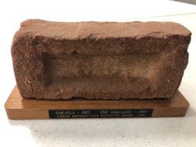
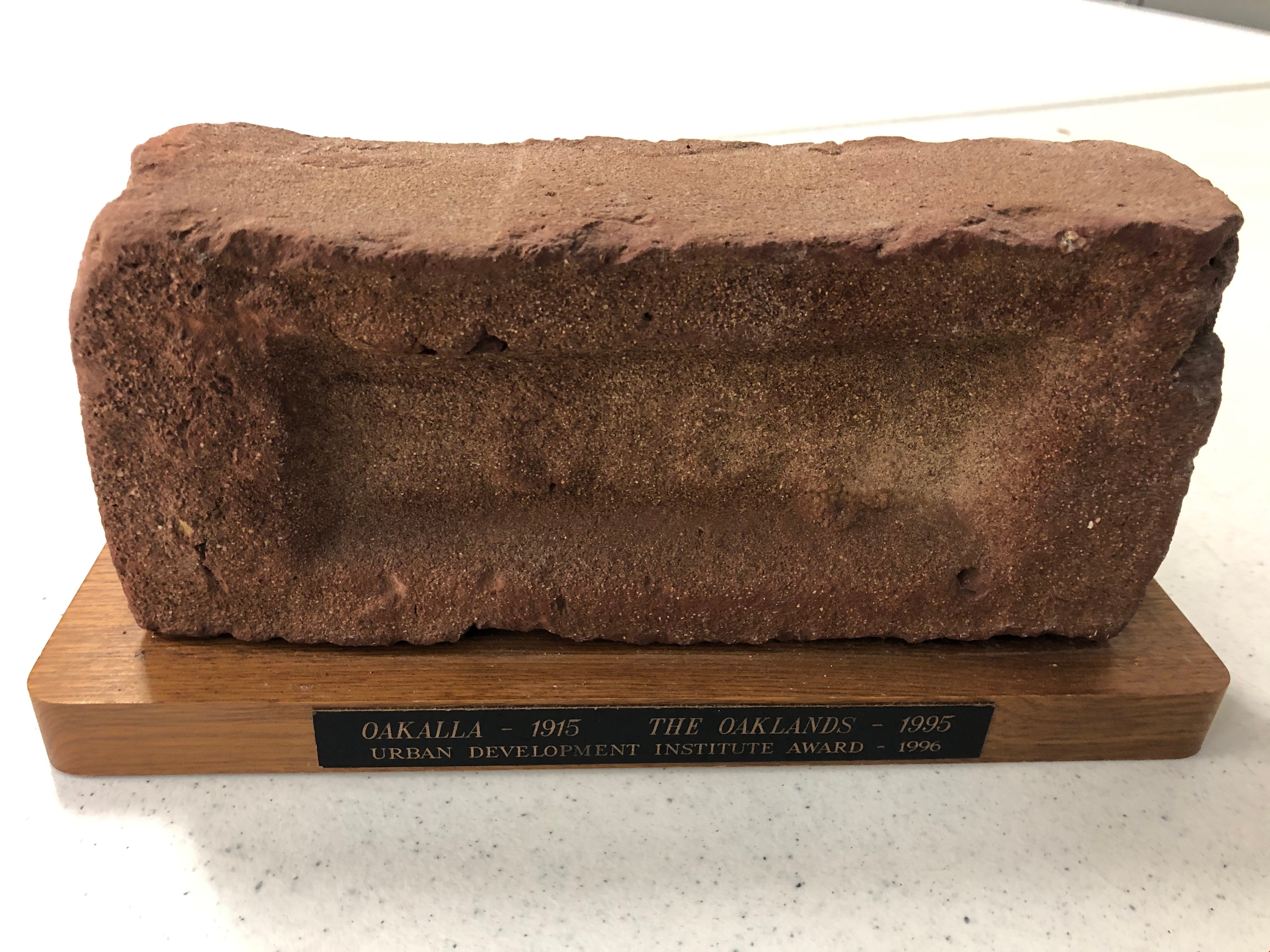
- Description
- Maroon brick mounted to a brown varnished wooden stand. On one long edge of the wooden stand is a black plaque with gold letteres reads: OAKALLA 1915 / THE OAKLANDS / Urban Development Institute Award - 1996
- Object History
- This was awarded to the City of Burnaby Planning Department by the Urban Development Institute in 1996 for the redevlopment of the lands which were Oakalla Provincial Prison from 1915-1991.
- Category
- 08. Communication Artifacts
- Classification
- Personal Symbols - - Achievement Symbols
- Object Term
- Trophy
- Colour
- Maroon
- Brown
- Subjects
- Building Components
- Ceremonies - Awards
- Planning - City Planning
- Public Services - Correctional
- Names
- Oakalla Prison Farm
- Historic Neighbourhood
- Central Park (Historic Neighbourhood)
- Planning Study Area
- Oakalla Area
Images
Urban structure : a study of long range policies which affect the physical structure of an urban area
https://search.heritageburnaby.ca/link/museumlibrary3813
- Repository
- Burnaby Village Museum
- Author
- Sixta, Gerhard
- Publication Date
- c1971
- Call Number
- 309.2620971133 SIX
- Repository
- Burnaby Village Museum
- Collection
- Special Collection
- Material Type
- Book
- Accession Code
- BV003.51.1
- Call Number
- 309.2620971133 SIX
- Author
- Sixta, Gerhard
- Place of Publication
- Burnaby, B.C.
- Publisher
- Planning Dept. of the District of Burnaby, B.C.
- Publication Date
- c1971
- Physical Description
- 144 p. : ill. (some col.), maps ; 31 cm.
- Library Subject (LOC)
- City planning
- Social policy
- British Columbia--Vancouver
- Subjects
- Planning - City Planning
- Notes
- Illustrated by Gerhard Sixta.
- Includes bibliographical references and index.
Planning Department fonds
https://search.heritageburnaby.ca/link/archivedescription102
- Repository
- City of Burnaby Archives
- Date
- 1940-2016
- Collection/Fonds
- Planning Department fonds
- Description Level
- Fonds
- Physical Description
- 80 m of textual records and other material
- Scope and Content
- Fonds consists of those records created during the regular conduct of business by the Planning Department and its predecessor agencies according to their mandate of providing professional and technical advice to Council on the current and future uses of City land and resources.
- Repository
- City of Burnaby Archives
- Date
- 1940-2016
- Collection/Fonds
- Planning Department fonds
- Physical Description
- 80 m of textual records and other material
- Description Level
- Fonds
- File Class
- 71000 10 (add. 2020)
- 71000 20 (add. 2020)
- 71000 30 (add. 2020)
- 71000 40 (add. 2020)
- Access Restriction
- Subject to FOIPPA
- Reproduction Restriction
- Reproductions subject to FOIPPA.
- Scope and Content
- Fonds consists of those records created during the regular conduct of business by the Planning Department and its predecessor agencies according to their mandate of providing professional and technical advice to Council on the current and future uses of City land and resources.
- History
- The City of Burnaby Planning Department was established on October 9, 1956, when the City Council unanimously carried the motion to create a distinct department to deal with planning issues within the City and appointed Mr. William John Blakely as its head. This decision followed a report and recommendation made by the City’s Chief Administrative Officer which indicated that the role of the Planning Engineer and his staff had quickly expanded to become a separate division within the Engineering Department and that they were functioning as an independent unit in all but name. The proposed separation of the Engineering and Planning departments had been in the works since the early part of 1956 when staff changes and restructuring within the Engineering Department’s Planning Division illustrated the undermanned condition of the Planning Engineer’s office. As a result, Council asked the Chief Administrative Officer to undertake a study examining the feasibility of creating a distinct Planning Department. This report was delivered to Council on July 3, 1956, but was laid over until a Committee of the Council had the opportunity to study the functions of the Planning department to determine the necessity of the proposal. The Committee’s findings were in line with the initial report and the Planning Department was established with a staff of nine (the head Planning Engineer, an Administrative Planner, three Research Planning Assistants, a Draughtsman, a Subdivision Control Clerk, a department Clerk and a Clerk Stenographer). This new department was to offer advice and carry out the work intensive in matters such as zoning and rezoning applications, subdivision control, traffic and transportation planning, and general City planning schemes. Prior to the creation of the Planning Department, a number of bodies within the City had been responsible for fulfilling the functions carried out by this new unit. In the earliest years of the City, the members of Council were responsible for matters of planning and were assisted in their job by the City’s Engineer or any number of hired consultants (e.g. surveyors, cartographers). By 1906, however, the provincial laws surrounding the subdivision process had changed, and local governments were charged with the task of approving all private subdivision plans in their respective Municipalities. In Burnaby, the City Council passed a bylaw decreeing that all subdivision plans were to be submitted to Council for review and the City Engineer was responsible for ensuring compliance with the law. After the first Town Planning Bylaw in 1924 which restricted the type and size of construction that could occur in certain City areas, the Engineering and Building departments were to work together to oversee the enforcement of the Bylaw and the development of City plans. The scope and competence required to carry out this work grew as Burnaby’s population expanded, and in 1930 Council passed the Town Planning Commission Bylaw (No. 1028) that saw the creation of a permanent body – the Town Planning Commission – which was to serve as an advisory body to help direct the planning activities in the City while the actual work continued to be carried out by the Engineering Department. This body was comprised of the Reeve, the Chairman of the School Board, the Chairman of the Park Committee (later, the Board of Parks Commissioners), and six appointed citizens who served three-year terms. Council referred all matters of subdivisions, transportation planning, and rezoning to this Commission, which was later supported in its work by several other special or standing committees such as the Subdivision Committee, the Apartment Committee, the Transportation Committee or the Town Planning Board of Appeal. By 1953, it had become apparent that the advisory committees that were dedicated to these planning issues needed a permanent staff to carry out the work intensive, so a restructuring of the Engineering department resulted in a permanent Planning Engineer’s office being created. The Town Planning Commission continued in its advisory capacity even after the determination came in 1956 to create a separate Planning Department. When Bylaw No. 4473 was passed in 1963, the Town Planning Commission was disbanded in favour of a new Advisory Planning Commission that would turn over all routine matters such as subdivision and rezoning applications to the Planning Department but would offer advice and community input into the more complex planning schemes within the City and act as an intermediary in cases where Council and Planning staff were in disagreement. A new Advisory Planning Commission Bylaw (No. 7600) was adopted in 1980 which allowed for even greater community participation in the planning process. The Planning Department was initially responsible to report directly to Council, but in 1957, the administrative structure of Municipal staff changed with the introduction of the Burnaby Municipal Manager Bylaw (No. 3859) and from that point on, the head of the Planning Department held a direct reporting relationship to the Municipal Manager, who in turn was responsible for reporting the activities of the Department to the City Council. Over the years, the internal structure and the scope of responsibilities of the Department have changed during periods of staff reorganizations. Under the larger umbrella of the Planning and Building Department, Planning has come to be comprised of two divisions: the Current Planning Division and the Long Range Planning Division. The functions of the Current Planning Division include rezoning, subdivision, development plan areas, preliminary plan approvals, urban design, heritage planning, and urban trails and bicycle routes. The Long Range Planning Division is responsible for environmental planning concerns, transportation planning, housing, neighbourhood area planning, social planning and planning information services. In 2022, the Planning and Building Department was reorganized to better align functions with delivery of services. The Climate Action and Engery Division moved from Corporate Services to the Planning and Building Department, while Indigenous Relations and Facilities Management moved to Corporate Services and Lands and Facilities, respectively. The position of Director of Planning and Building was changed to General Manager, Planning and Development. The following individuals have served as Planning Engineer and/or Director of the Planning Department and/or General Manager, Planning and Development for the City of Burnaby: William John Blakely 1954-1956 (as Planning Engineer) 1956-1963 (as Head of the Department) Anthony P. Parr 1964-1993 Don G. Stenson 1993-2001 Jack S. Belhouse 2001-2006 Basil Luksun 2006-2012 Lou Pelletier 2012-2019 Edward Kozak 2019-present
- Formats
- Microforms exist for some records. See series descriptions.
- Media Type
- Textual Record
- Photograph
- Moving Images
- Creator
- City of Burnaby
- Notes
- Title based on contents of fonds