Narrow Results By
Barnet Neighbourhood
https://search.heritageburnaby.ca/link/landmark681
- Repository
- Burnaby Heritage Planning
- Associated Dates
- 1925-1954
- Heritage Value
- In 1925, the mill at Barnet was under new ownership and was known as the Barnet Lumber Company. It was one of the most successful local employers in Burnaby until the 1930s, when the economic crisis of the Great Depression resulted in a strike at the mill. The City of Burnaby eventually assumed control of the site - including all of the homes - when the company failed to pay its taxes. The City then dismantled the mill and resold the property in two parts - the eastern section would become the Kapoor sawmill and the western portion, the McColl-Frontenac Oil Company.
- Historic Neighbourhood
- Barnet (Historic Neighbourhood)
- Planning Study Area
- Burnaby Mountain Area
Images
E.W. Bateman House 'Elworth'
https://search.heritageburnaby.ca/link/landmark538
- Repository
- Burnaby Heritage Planning
- Description
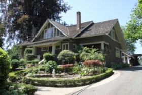
- The E.W. Bateman House is a one-and-one-half storey wood-frame residence set within in a garden landscape. The house and its adjacent garage are the only historic buildings standing on their original site within the Burnaby Village Museum property.
- Associated Dates
- 1922
- Formal Recognition
- Heritage Designation, Community Heritage Register
- Other Names
- Edwin & Mary Bateman Residence
- Street View URL
- Google Maps Street View
- Repository
- Burnaby Heritage Planning
- Other Names
- Edwin & Mary Bateman Residence
- Geographic Access
- Deer Lake Avenue
- Associated Dates
- 1922
- Formal Recognition
- Heritage Designation, Community Heritage Register
- Enactment Type
- Bylaw No. 9807
- Enactment Date
- 23/11/1992
- Description
- The E.W. Bateman House is a one-and-one-half storey wood-frame residence set within in a garden landscape. The house and its adjacent garage are the only historic buildings standing on their original site within the Burnaby Village Museum property.
- Heritage Value
- The E.W. Bateman House was constructed in the Deer Lake Crescent subdivision, that was originally promoted in 1911 as an upper class suburban neighbourhood. It represents one of the first residential developments in the City of Burnaby that required buildings to be of a specific value, thus demonstrating the desire for exclusivity among the successful businessmen who chose to settle in the area. The house and grounds illustrate the reduced scale of upper-class residential construction at a time of modest returning prosperity that followed the end of the First World War, and the social, cultural, lifestyle and leisure sensibilities of the owners in the Deer Lake Crescent subdivision: such values as social aspiration, racial exclusivity, demonstration of architectural taste, and importance of a landscaped garden. The heritage value of the E.W. Bateman House is its comprehensive representation of an upper middle-class suburban residence of the early 1920s. It was built for retired CPR executive Edwin Wettenhall Bateman (1859-1957) and his wife, Mary (Dale) Bateman (1865-1935), by contractor William Dodson in 1922. The Bateman House was designed by English-born and trained architect Enoch Evans (1862-1939) of E. Evans and Son, and is an important surviving residential design by Evans, and a typical example of the eclectic Period Revival influences that were common to domestic architecture in the post-First World War era. The symmetry of the imposing front verandah, supported by exaggerated Ionic columns, gives the relatively-modest house an image of grandeur and formality. Named after Edwin Bateman’s birthplace in Cheshire, England, ‘Elworth’ also symbolizes allegiance to England and the patriotic tenor of the time. The heritage value for this house also lies in its interpretive value within the Burnaby Village Museum. The site is an important cultural feature for the interpretation of Burnaby’s heritage to the public. The E.W. Bateman House was purchased by Burnaby in 1970 and became the focal point for the development of the Museum. Both the interior and exterior of the house have been restored and interpreted to the date of original construction, including recreated room interiors and period furnishings.
- Defining Elements
- The elements that define the heritage character of the E.W. Bateman House include its: - rectangular form and massing with central entry on long side - side gable roof with front shed dormer with cedar shingle cladding - symmetry of front facade - full open front verandah inset under the roofline, supported with Ionic columns - cedar shingle siding - multi-paned double-hung wooden-sash windows, mixture of 6-over-1 and 8-over-1 - symmetrical disposition of fenestration, with double-assembly units on the ground floor - exterior shutters - two flanking brick chimneys on the side elevations - interior room layouts and original interior features such as quality millwork and original hardware - original garage at the rear of the house
- Locality
- Deer Lake Park
- Historic Neighbourhood
- Burnaby Lake (Historic Neighbourhood)
- Planning Study Area
- Morley-Buckingham Area
- Organization
- Burnaby Village Museum
- Architect
- Enoch Evans
- E. Evans and Son
- Builder
- William Dodson
- Function
- Primary Current--Museum
- Primary Historic--Single Dwelling
- Community
- Burnaby
- Cadastral Identifier
- P.I.D. No. 011-030-356 Legal Description: Parcel 1, District Lot 79 and District Lot 85, Group 1, New Westminster District, Reference Plan 77594
- Boundaries
- Burnaby Village Museum is comprised of a single municipally-owned property located at 6501 Deer Lake Avenue, Burnaby.
- Area
- 38,488.63
- Contributing Resource
- Building
- Landscape Feature
- Structure
- Ownership
- Public (local)
- Documentation
- Heritage Site Files: PC77000 20. City of Burnaby Planning and Building Department, 4949 Canada Way, Burnaby, B.C., V5G 1M2
- Subjects
- Buildings - Residential
- Buildings - Residential - Houses
- Buildings - Heritage
- Buildings - Civic - Museums
- Street Address
- 6501 Deer Lake Avenue
- Street View URL
- Google Maps Street View
Images
Floden House
https://search.heritageburnaby.ca/link/landmark524
- Repository
- Burnaby Heritage Planning
- Description
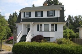
- The Floden House is a gambrel roofed, one and one-half storey plus basement wood-frame Dutch Colonial Revival residence, located at the head of the T-intersection of Fourth Street and Edmonds Street in a residential area of East Burnaby.
- Associated Dates
- 1929
- Formal Recognition
- Heritage Designation, Community Heritage Register
- Other Names
- Eric B. & Carrie Floden House
- Street View URL
- Google Maps Street View
- Repository
- Burnaby Heritage Planning
- Other Names
- Eric B. & Carrie Floden House
- Geographic Access
- 4th Street
- Associated Dates
- 1929
- Formal Recognition
- Heritage Designation, Community Heritage Register
- Enactment Type
- Bylaw No. 11358
- Enactment Date
- 27/05/2002
- Description
- The Floden House is a gambrel roofed, one and one-half storey plus basement wood-frame Dutch Colonial Revival residence, located at the head of the T-intersection of Fourth Street and Edmonds Street in a residential area of East Burnaby.
- Heritage Value
- Built in 1929 for Swedish emigrant Eric Birger Floden (1896-1971) and his Norwegian wife, Carrie (1899-1943), the Floden House is a valued representation of local middle-class housing from the 1920s, at a time of increasing prosperity just prior to the onset of the Great Depression. Eric Birger Floden was the head sawyer at Shook Mills in New Westminster, and his family occupied the house until 1964. Additionally, the Floden House is significant as an example of a residential pattern book design from the 1920s. With a reviving economy after the First World War, pattern books were widely used to expedite residential design and construction. It was built by Floden's brother in-law, Nels Olund, a talented contractor of the Fraser Valley who was experienced in building gambrel roof barns. The Floden House is also valued as an example of the Dutch Colonial Revival style, and is typical of period revival houses built in the 1920s that reflected the modern ideals of economy and good design as well as an ongoing pride in past traditions. It was presumed at the time that a well-built house would display a traditional and readily-identifiable style as a hallmark of good taste. The use of the various Colonial Revival styles had gained new popularity during the late 1920s at the time of the American Sesquicentennial. A local landmark, the house originally stood at 7997 18th Avenue and was moved two blocks to its current location by the City of Burnaby when it purchased and rehabilitated the house to save it from demolition, indicating the City's commitment to heritage conservation.
- Defining Elements
- Key elements that define the heritage character of the Floden House include its: - residential form, scale and massing as expressed by its one and one-half storey plus basement height, rectangular plan and distinctive roof form - Dutch Colonial Revival style details such as its side gambrel roof, front and rear shed dormers, attic fanlights, decorative shutters and regular fenestration - roof configuration, with overhanging eaves on the front facade with returns on the side facades, and clipped eaves on the side facades - asymmetrical front entry with small entry porch with lattice surrounds - front projecting bay window - wide lapped horizontal cedar siding - irregular fenestration, with original double-hung 6-over-1 wooden-sash windows - secondary side entry with balcony over - internal red brick chimney with concrete chimney caps
- Historic Neighbourhood
- East Burnaby (Historic Neighbourhood)
- Planning Study Area
- Edmonds Area
- Builder
- Nels Olund
- Function
- Primary Historic--Single Dwelling
- Primary Current--Single Dwelling
- Community
- Burnaby
- Cadastral Identifier
- 009-931-490
- Boundaries
- The Floden House is comprised of a single residential lot located at 7244 Fourth Street, Burnaby.
- Area
- 804.13
- Contributing Resource
- Building
- Ownership
- Private
- Street Address
- 7244 4th Street
- Street View URL
- Google Maps Street View
Images
Frederick & Edna Cunningham House
https://search.heritageburnaby.ca/link/landmark522
- Repository
- Burnaby Heritage Planning
- Description
- Set back from Douglas Road, the Frederick and Edna Cunningham House is a picturesque wood-frame one and one-half storey British Arts and Crafts-style residence, clad with rough-cast stucco and featuring half-timbering in the gable ends. Set far back on a large east-sloping site in a mature landscap…
- Associated Dates
- 1923
- Formal Recognition
- Heritage Designation, Community Heritage Register
- Street View URL
- Google Maps Street View
- Repository
- Burnaby Heritage Planning
- Geographic Access
- Douglas Road
- Associated Dates
- 1923
- Formal Recognition
- Heritage Designation, Community Heritage Register
- Enactment Type
- Bylaw No. 10470
- Enactment Date
- 04/11/1996
- Description
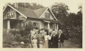
- Set back from Douglas Road, the Frederick and Edna Cunningham House is a picturesque wood-frame one and one-half storey British Arts and Crafts-style residence, clad with rough-cast stucco and featuring half-timbering in the gable ends. Set far back on a large east-sloping site in a mature landscape setting, it is located in the Douglas Road neighbourhood located in the central valley of Burnaby.
- Heritage Value
- Considered a landmark in the Douglas Road neighbourhood, the Cunningham House is valued as a good example of a British Arts and Crafts-style residence. The house blends into its surroundings, which are extensively landscaped with rockeries, lawns, shrubs, trees and perennial beds. The two majestic copper beech trees, over 60 years old, are among the best specimens of their type to be found in Greater Vancouver and are protected under covenant. The Cunningham property is significant as one of the last estate homes remaining on the old Douglas Road, at one time noted for its beautiful estates set within the rural character of Burnaby’s Central Valley. Insurance agent Frederick Woodman Cunningham (1882-1963) and his wife, Edna Elizabeth Cunningham (1884-1982), built this country residence in 1923. Fred was the only son of James Cunningham, a pioneer of New Westminster who arrived in 1862 and served as the City’s Mayor from 1872 to 1874. The landmark flagpole that once stood in the garden was moved to this site when Fred Cunningham's prestigious family home in New Westminster at Third Avenue and Seventh Street was demolished in 1938. Kept within the family until 1982 and largely maintained in its original condition, the Cunningham House is an excellent example of one of Burnaby's best estate homes from the 1920s and was designated by the City of Burnaby in 1996.
- Defining Elements
- Key elements that define the heritage character of the Cunningham House include its: - location on Douglas Road, in Burnaby’s Central Valley - views from the property to the east and towards the North Shore - residential form, scale and massing as exemplified by its one and one-half storey height and rectangular plan - side gabled roof with front gabled dormer and cedar shingle cladding - British Arts and Crafts elements such as its rough-cast stucco, tapered porch columns, large eave brackets, exposed purlins and half-timbering - irregular fenestration including double-hung 1-over-1 wooden-sash windows, multi-pane wooden-sash casement windows and multiple-assembly windows in the gable ends - front entrance porch with shed roof - two internal red brick chimneys - early cedar-shingled garage at side of house - associated landscape features, including two landmark Copper beech trees and landscaped rockeries at the front of the property
- Historic Neighbourhood
- Burnaby Lake (Historic Neighbourhood)
- Planning Study Area
- Douglas-Gilpin Area
- Function
- Primary Historic--Single Dwelling
- Primary Current--Single Dwelling
- Community
- Burnaby
- Cadastral Identifier
- 003-118-746
- Boundaries
- The Cunningham House is comprised of a single residential lot located at 3555 Douglas Road, Burnaby.
- Area
- 4446.5
- Contributing Resource
- Building
- Ownership
- Private
- Street Address
- 3555 Douglas Road
- Street View URL
- Google Maps Street View
Images
Louis & Annie Hill Residence
https://search.heritageburnaby.ca/link/landmark504
- Repository
- Burnaby Heritage Planning
- Description
- The Louis and Annie Hill Residence is a modest one-storey, wood-frame, side-gabled Arts and Crafts bungalow with two projecting front gables, that was originally part of the Deer Lake Crescent Subdivision. The lot is heavily treed, and sits near the east end of Deer Lake.
- Associated Dates
- 1925
- Street View URL
- Google Maps Street View
- Repository
- Burnaby Heritage Planning
- Geographic Access
- Deer Lake Avenue
- Associated Dates
- 1925
- Description
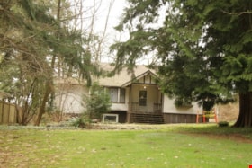
- The Louis and Annie Hill Residence is a modest one-storey, wood-frame, side-gabled Arts and Crafts bungalow with two projecting front gables, that was originally part of the Deer Lake Crescent Subdivision. The lot is heavily treed, and sits near the east end of Deer Lake.
- Heritage Value
- The heritage value of the Louis and Annie Hill Residence lies in its association with prominent Burnaby pioneers, Louis Hill (1860-1931) and his wife, Annie Sara Hill (née Kenrick, 1864-1957). Originally from London, England, Louis Hill immigrated to Burnaby circa 1887, and established a small fruit farm on this site in 1891. Hill was elected to the first municipal council in 1892, when Burnaby was incorporated, and was later responsible for the subdivision of Buckingham Estate in the Deer Lake neighbourhood. The Louis and Annie Hill Residence, built as a retirement home in 1925, is further valued as a representation of the continued suburban development of the Deer Lake Crescent Subdivision, that was originally promoted in 1911 as an upper class suburban neighbourhood. Its modest nature illustrates the reduced scale of residential construction during the austere times that followed the end of the First World War. The style of the house demonstrates the late persistence of the Arts and Crafts movement, which remained a strong influence on domestic architecture. In 2006, the Louis and Annie Hill Residence was purchased by the City of Burnaby, and today it is part of the Deer Lake Park Heritage Precinct, Burnaby's most significant collection of historic sites.
- Defining Elements
- Key elements that define the heritage character of the Louis and Annie Hill Residence include its: - location within the Deer Lake Park Heritage Precinct - residential form, scale and massing as expressed by its one-storey height plus crawlspace, side-gabled-roof, front projecting gables, square projecting front bay and open front porch - wood-frame construction with original wood siding intact under a later coat of stucco - modest Arts and Crafts details such as diamond-point triangular eave brackets - windows, including double-hung, 1-over-1 wooden sash windows with horns - associated landscape features, including mature cedars lining the driveway
- Historic Neighbourhood
- Burnaby Lake (Historic Neighbourhood)
- Planning Study Area
- Morley-Buckingham Area
- Function
- Primary Historic--Single Dwelling
- Primary Current--Single Dwelling
- Community
- Deer Lake
- Cadastral Identifier
- P.I.D.012-446-963
- Boundaries
- The Louis and Annie Hill Residence is comprised of a single residential lot located at 6570 Deer Lake Avenue, Burnaby.
- Area
- 1521.75
- Contributing Resource
- Building
- Ownership
- Public (local)
- Documentation
- City of Burnaby Planning and Building Department, Heritage Site Files
- Street Address
- 6570 Deer Lake Avenue
- Street View URL
- Google Maps Street View


