Narrow Results By
Subject
- Accidents 1
- Accidents - Automobile Accidents 1
- Adornment 1
- Advertising Medium 5
- Advertising Medium - Business Cards 1
- Advertising Medium - Signs and Signboards 70
- Aerial Photographs 11
- Agricultural Tools and Equipment - Gardening Equipment 1
- Agricultural Tools and Equipment - Plows 1
- Agriculture - Crops 4
- Agriculture - Farms 11
- Agriculture - Fruit and Berries 5

George & Mary Buxton Residence
https://search.heritageburnaby.ca/link/landmark583
- Repository
- Burnaby Heritage Planning
- Description
- Residential building.
- Associated Dates
- c.1912
- Street View URL
- Google Maps Street View
- Repository
- Burnaby Heritage Planning
- Geographic Access
- Buxton Street
- Associated Dates
- c.1912
- Description
- Residential building.
- Heritage Value
- George Searby Buxton (1867-1955), an English-born carpenter, built this Arts and Crafts dwelling and resided here with his wife and local teacher Mary Isabel Buxton (née Nattriss, 1865-1941). George and Mary are both buried in the picturesque St. Helen’s Anglican Church cemetery in Surrey. The house retains this style’s characteristic elements such as half-timbering, an oriel window and turned verandah supports, as well as its distinctive windows, which are casements in the lower portion of the frame and a fixed multi-paned sash in the upper. The original siding has been covered with a later coat of stucco. The house survives in well-maintained condition.
- Locality
- Central Park
- Historic Neighbourhood
- Central Park (Historic Neighbourhood)
- Planning Study Area
- Marlborough Area
- Area
- 868.85
- Contributing Resource
- Building
- Ownership
- Private
- Street Address
- 4807 Buxton Street
- Street View URL
- Google Maps Street View
Images


Henry Adams Residence
https://search.heritageburnaby.ca/link/landmark593
- Repository
- Burnaby Heritage Planning
- Description
- Residential building.
- Associated Dates
- c.1913
- Street View URL
- Google Maps Street View
- Repository
- Burnaby Heritage Planning
- Geographic Access
- Buxton Street
- Associated Dates
- c.1913
- Description
- Residential building.
- Heritage Value
- Carpenter Henry J. Adams constructed this side-gabled, shingle-clad bungalow circa 1913, with his neighbour, George S. Buxton (1867-1955), who was also a carpenter. The house is distinguished by its beautifully-detailed wraparound verandah, which is supported by square, tapered columns, and its distinctive semicircular window in the projecting front gable. Other details include a subtly flattened arched opening under the gable, leading to the central front entry.
- Historic Neighbourhood
- Central Park (Historic Neighbourhood)
- Planning Study Area
- Marlborough Area
- Area
- 864.56
- Contributing Resource
- Building
- Ownership
- Private
- Street Address
- 4826 Buxton Street
- Street View URL
- Google Maps Street View
Images


Central Park Neighbourhood
https://search.heritageburnaby.ca/link/landmark688
- Repository
- Burnaby Heritage Planning
- Associated Dates
- 1925-1954
- Heritage Value
- Although still largely a rural area during the 1920s, subdivisions began appearing in the Central Park neighbourhood at this time. Development was slowed by the Great Depression of the 1930s but the influx of commercial buildings and new housing initiatives in the post-war boom led to a period of rapid growth especially in the Garden Village subdivision which was undertaken in 1953 with the plan to build 500 modern homes in the 140-acre site. Despite the closure of the interurban line in 1953, the neighbourhood remained an active commercial and residential centre.
- Historic Neighbourhood
- Central Park (Historic Neighbourhood)
- Planning Study Area
- Maywood Area
Images


Central Park Neighbourhood
https://search.heritageburnaby.ca/link/landmark723
- Repository
- Burnaby Heritage Planning
- Associated Dates
- 1891-1904
- Heritage Value
- Central Park was one of the first and fastest-growing communities in Burnaby. Located along the electric tram line and the Vancouver Road (Kingsway), it was also chosen for a government settlement project referred to as the Central Park Small Holdings. The lands held by the Provincial Government were subdivided and sold around 1894 and by 1899 the settlement was large enough to warrant the construction of an Anglican Church there.
- Historic Neighbourhood
- Central Park (Historic Neighbourhood)
- Planning Study Area
- Maywood Area
Images


Central Park Neighbourhood
https://search.heritageburnaby.ca/link/landmark751
- Repository
- Burnaby Heritage Planning
- Associated Dates
- 1905-1924
- Heritage Value
- In 1906, Maxwell Smith, President of the Central Park Farmer's Institute gave a speech in which he commented on the growth of this district and its ideal location during the boom years after 1905. He said: "Central Park is destined to become the epicentre of a great commercial metropolis, when Vancouver and New Westminster will have both expanded and prospered until they meet and fill up the intervening distances with residences of a new city, greater than few can now imagine, even in their wildest flights of fancy...we are proud of the two cities that lie on either side of us but they are, but mere hamlets compared with the great city that is to be on this peninsula. The time is coming when there will be one vast city, one commercial metropolis, and Central Park will be the heart of it."
- Historic Neighbourhood
- Central Park (Historic Neighbourhood)
- Planning Study Area
- Maywood Area
Images


Garden Village Neighbourhood
https://search.heritageburnaby.ca/link/landmark800
- Repository
- Burnaby Heritage Planning
- Associated Dates
- 1955-2008
- Heritage Value
- Bounded by Moscrop Street to the north, Kingsway and Grange to the south, Willingdon to the east and Boundary Road to the west, the Garden Village Neighbourhood is characterised as a primarily residential area that is well-served due to its proximity to commercial, park and business centres. The north-east corner of the neighbourhood is a typical 1950s subdivision of mostly single family homes located on an irregular street pattern, while the remaining areas saw some transition to multi-family housing types throughout the 1970s and up to the current time.
- Historic Neighbourhood
- Central Park (Historic Neighbourhood)
- Planning Study Area
- Garden Village Area
Images


Maywood Neighbourhood
https://search.heritageburnaby.ca/link/landmark801
- Repository
- Burnaby Heritage Planning
- Associated Dates
- 1955-2008
- Heritage Value
- Burnaby's Maywood Neighbourhood consists of the Metrotown Town Centre - one of four Town Centres in the City. Metrotown is one of the region's most developed and fastest growing centres. It is served by the first SkyTrain line developed in the mid-1980s and anchored by B.C.'s largest shopping and entertainment complex. As an older centre that has progressively added new developments over the years, Metrotown offers a range of housing types and tenures from three-storey walk-up apartments to modern residential towers.
- Historic Neighbourhood
- Central Park (Historic Neighbourhood)
- Planning Study Area
- Maywood Area
Images


Marlborough Neighbourhood
https://search.heritageburnaby.ca/link/landmark802
- Repository
- Burnaby Heritage Planning
- Associated Dates
- 1955-2008
- Heritage Value
- The Marlborough Neighbourhood is another residential area that was witness to rapid growth and subdivision during the 1950s and 1960s, creating primarily single-family housing stock. In the 1970s and 1980s, as the commercial district around Kingsway grew, so too did higher density housing projects such as townhomes and condominiums.
- Historic Neighbourhood
- Central Park (Historic Neighbourhood)
- Planning Study Area
- Marlborough Area
Images


Oakalla Neighbourhood
https://search.heritageburnaby.ca/link/landmark804
- Repository
- Burnaby Heritage Planning
- Associated Dates
- 1955-2008
- Heritage Value
- The phasing out and demolition of the Oakalla Prison farm allowed for the planned development of the Oakalla Neighbourhood in the 1980s. By 1991, the City of Burnaby had adopted the Oakalla Development Plan which called for the transfer of land to the Deer Lake Park reserve as well as the creation of a new residential area consisting of multi-family housing types.
- Historic Neighbourhood
- Central Park (Historic Neighbourhood)
- Planning Study Area
- Oakalla Area
Images


Suncrest Neighbourhood
https://search.heritageburnaby.ca/link/landmark839
- Repository
- Burnaby Heritage Planning
- Associated Dates
- 1955-2008
- Heritage Value
- The Suncrest Neighbourhood is a small residential area south of Burnaby's Central Park. The Ocean View Burial Park takes up a large area of land in the north-east corner of this neighbourhood and the majority of the housing was built during the 1930-1960 period.
- Historic Neighbourhood
- Alta Vista (Historic Neighbourhood)
- Planning Study Area
- Suncrest Area
Images

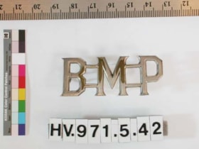
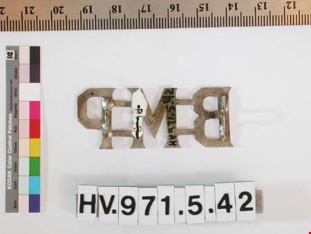
shoulder badge
https://search.heritageburnaby.ca/link/museumartifact204
- Repository
- Burnaby Village Museum
- Accession Code
- HV971.5.42
- Description
- Burnaby Municipal Police shoulder bar for jacket. Cast in one piece in metal. Letters are connected by integral bars. Secured by mounting posts and cotter pin.
- Object History
- Jacket shoulder bars issued to Constable George Jeffery. George Jeffery served as a Constable on the Burnaby Police Force from 1912 - 1935. His patrolled the large Central Park District by foot, stretching from Boundary to Royal Oak and Marine Drive to Moscrop. Over the coarse of his duties, Constable Jeffery saw the need for recreational activities in the area. He founded the Burnaby Athletic Association which featured a competitive boxing ring and gym. In 1935, when the Burnaby Police became the British Columbia Provincial Police, rather than leave the community he chose to leave the force. George Jeffery than worked at the nearby Oakalla Prison Farm until retiring in 1945.
- Marks/Labels
- "B M P", letters on cross bars
Images


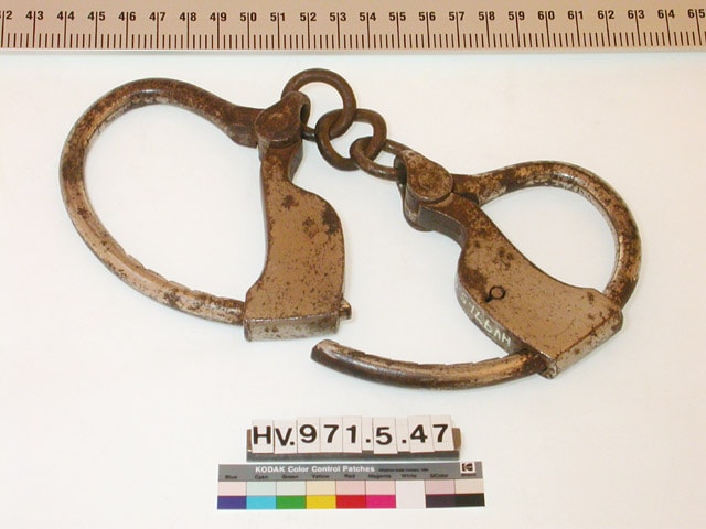
handcuffs
https://search.heritageburnaby.ca/link/museumartifact209
- Repository
- Burnaby Village Museum
- Accession Code
- HV971.5.47
- Description
- Burnaby Municipal Police issue handcuffs. The cuffs are secured by three links of chain. There is no key.
- Object History
- These handcuffs were used by Constable George Jeffery. George Jeffery served as a Constable on the Burnaby Police Force from 1912 - 1935. His patrolled the large Central Park District by foot, stretching from Boundary to Royal Oak and Marine Drive to Moscrop. Over the coarse of his duties, Constable Jeffery saw the need for recreational activities in the area. He founded the Burnaby Athletic Association which featured a competitive boxing ring and gym. In 1935, when the Burnaby Police became the British Columbia Provincial Police, rather than leave the community he chose to leave the force. George Jeffery than worked at the nearby Oakalla Prison Farm until retiring in 1945.
Images


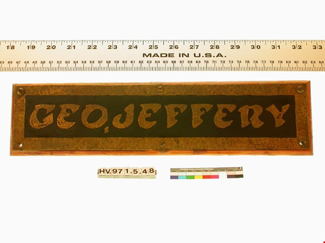
name plate
https://search.heritageburnaby.ca/link/museumartifact210
- Repository
- Burnaby Village Museum
- Accession Code
- HV971.5.48
- Description
- Name plate "GEO. JEFFERY" made for Burnaby Municipal Police officer George Jeffery by schoolchildren. Rectangular copper plate with letters and border raised by hammering on the reverse side. Background is darkened by acid treatment.
- Object History
- Made for Burnaby Municipal Police officer George Jeffery by schoolchildren. George Jeffery served as a Constable on the Burnaby Police Force from 1912 - 1935. His patrolled the large Central Park District by foot, stretching from Boundary to Royal Oak and Marine Drive to Moscrop. Over the coarse of his duties, Constable Jeffery saw the need for recreational activities in the area. He founded the Burnaby Athletic Association which featured a competitive boxing ring and gym. In 1935, when the Burnaby Police became the British Columbia Provincial Police, rather than leave the community he chose to leave the force. George Jeffery then worked at the nearby Oakalla Prison Farm until retiring in 1945.
- Marks/Labels
- "GEO. JEFFERY", letters raised by hammering.
Images
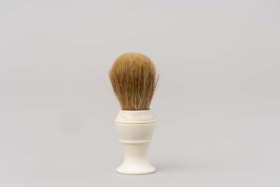
Shaving brush
https://search.heritageburnaby.ca/link/museumartifact212
- Repository
- Burnaby Village Museum
- Accession Code
- HV971.5.50
- Description
- Handheld shaving brush with a white plastic base and tan bristles. Used for mixing and applying shaving cream.
- Object History
- This item belonged to George Jeffery served as a Constable on the Burnaby Police Force from 1912 - 1935. His patrolled the large Central Park District on foot, stretching from Boundary to Royal Oak and Marine Drive to Moscrop. Over the coarse of his duties, Constable Jeffery saw the need for recreational activities in the area. He founded the Burnaby Athletic Association which featured a competitive boxing ring and gym. In 1935, when the Burnaby Police became the British Columbia Provincial Police, rather than leave the community he chose to leave the force. George Jeffery then worked at the nearby Oakalla Prison Farm until retiring in 1945.
- Category
- 03. Personal Artifacts
- Classification
- Personal Gear - - Personal Assistive Artifacts
- Object Term
- Brush
- Marks/Labels
- On the base of the brush "STERILIZED ADGER" "MADE IN" "CANADA" "PEERLESS" "PURE".
- Subjects
- Toilet Articles
- Historic Neighbourhood
- Central Park (Historic Neighbourhood)
- Planning Study Area
- Oakalla Area
Images

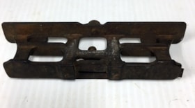
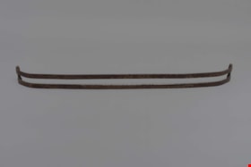
Saw jointer and gauge
https://search.heritageburnaby.ca/link/museumartifact244
- Repository
- Burnaby Village Museum
- Accession Code
- HV971.5.82
- Description
- A cast iron gauge of the same design as the Atkins excelsior saw tool Co. It is approximately rectangular in shape with three horizontal bands and four vertical supporting pillars. On the top a set screw is present. A notch is present in the base plate held in place with two short slotted screws and with a smaller adjustment screw above. Markings cast into the saw gauge appear to be: On one side: "MORIN" "PAT/69" "JUNE" "S.J." "SEATTLE" On the other side: "SEATTLE" "1900"
- Object History
- George Jeffery served as a Constable on the Burnaby Police Force from 1912 - 1935. His patrolled the large Central Park District by foot, stretching from Boundary to Royal Oak and Marine Drive to Moscrop. Over the coarse of his duties, Constable Jeffery saw the need for recreational activities in the area. He founded the Burnaby Athletic Association which featured a competitive boxing ring and gym. In 1935, when the Burnaby Police became the British Columbia Provincial Police, rather than leave the community he chose to leave the force. George Jeffery then worked at the nearby Oakalla Prison Farm until retiring in 1945.
- Measurements
- Overall measurements: Length: 16.6 cm Width: 2.5 cm Height: 4.4 cm
- Names
- Oakalla Prison Farm
Images


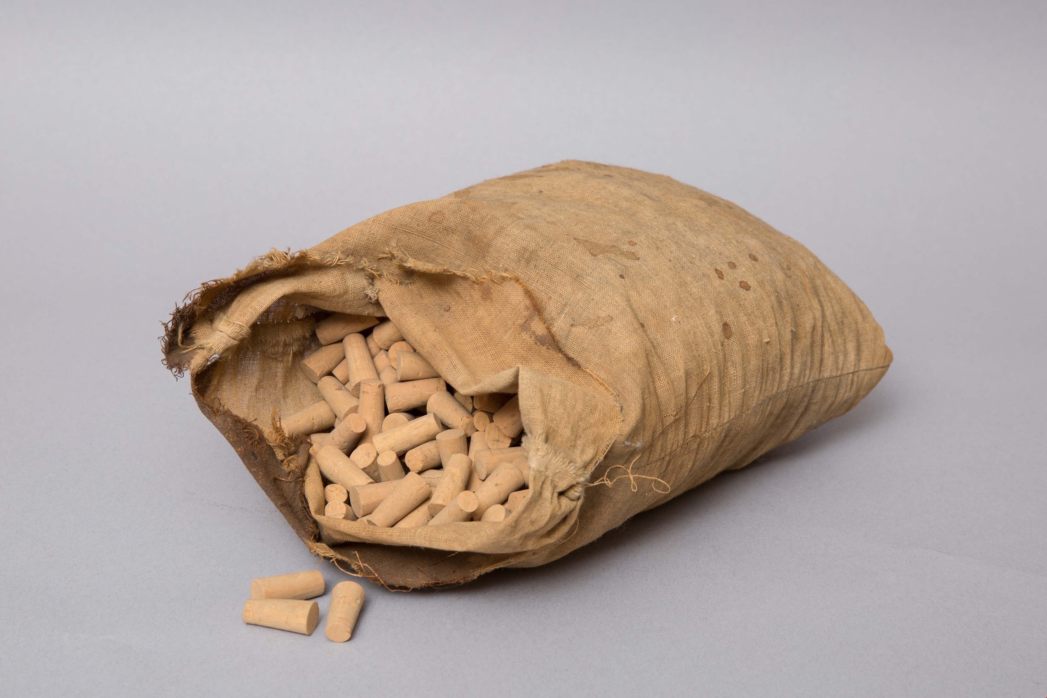
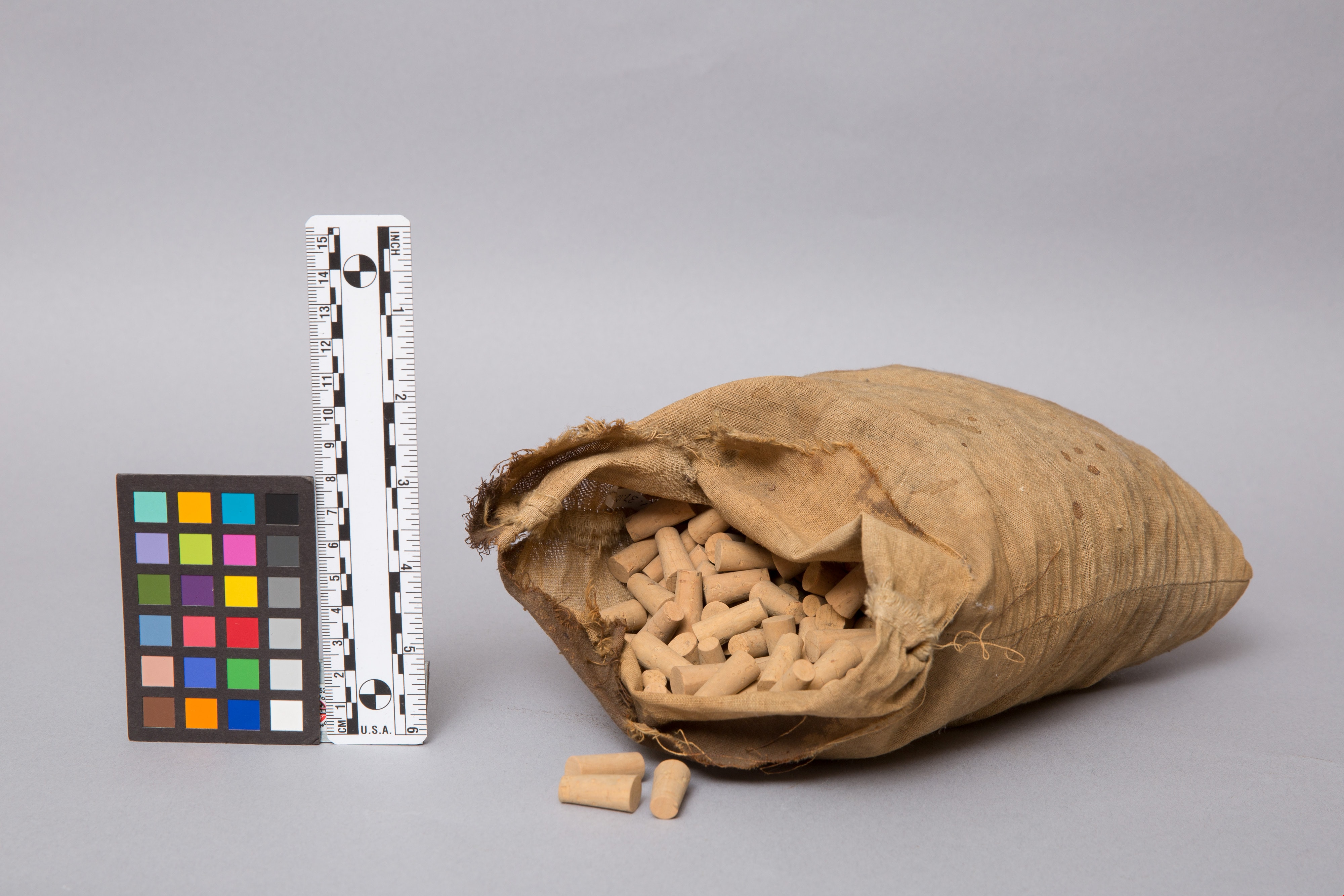
bag of corks
https://search.heritageburnaby.ca/link/museumartifact1328
- Repository
- Burnaby Village Museum
- Accession Code
- HV971.37.106
- Description
- Beige, flour sack-type cloth bag filled with unused corks. Open at top. Stitching along sides. Some stains on cloth.
- Object History
- This item originates from the Central Park Pharmacy in Burnaby.
- Classification
- Chemical T&E
- Marks/Labels
- no label found
- Names
- Central Park Pharmacy
- Geographic Access
- Central Park
- Historic Neighbourhood
- Central Park (Historic Neighbourhood)
- Planning Study Area
- Maywood Area
Images
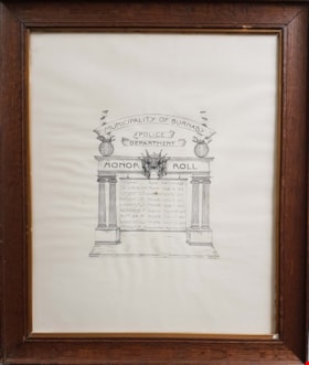
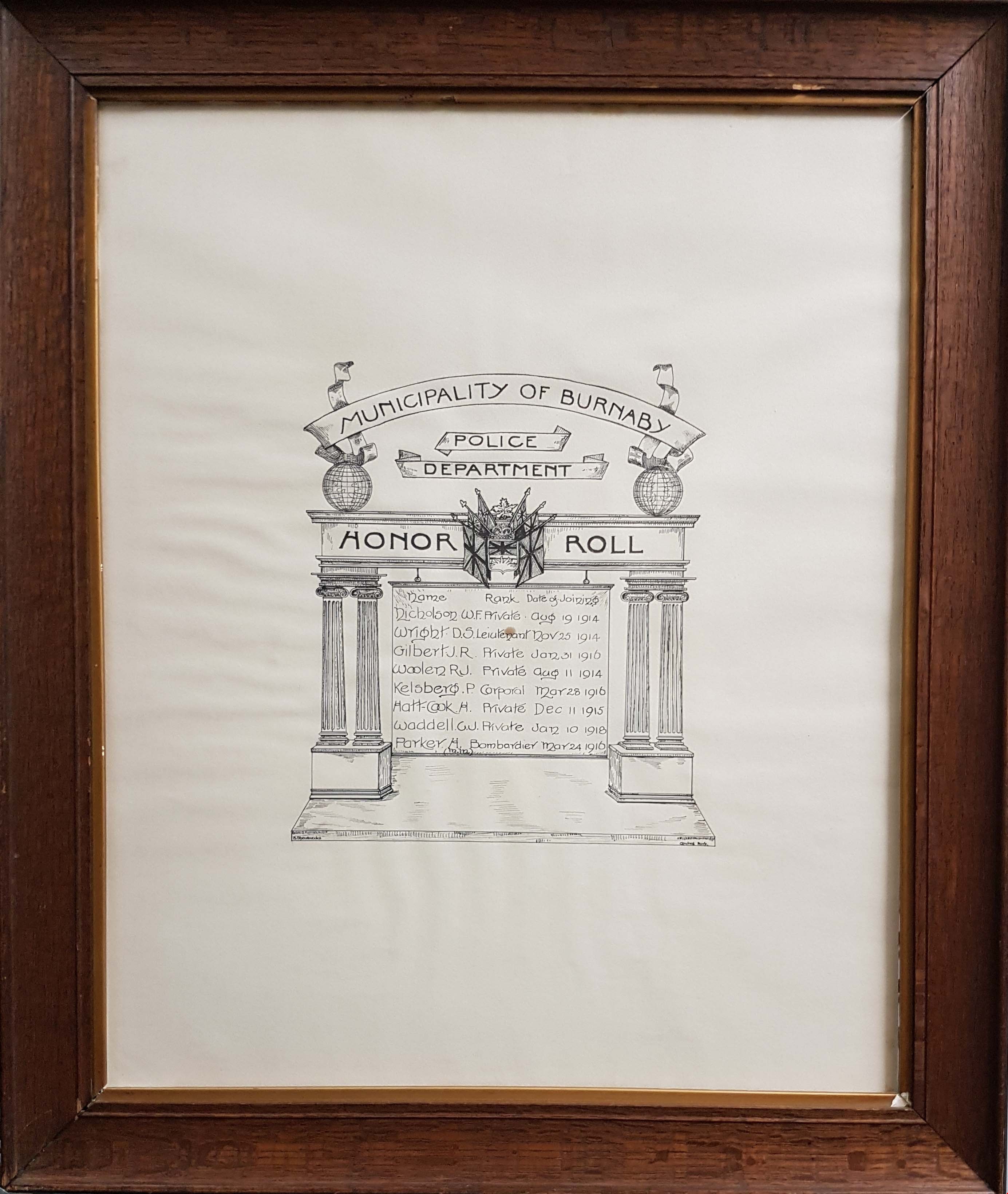
honor roll with frame
https://search.heritageburnaby.ca/link/museumartifact3931
- Repository
- Burnaby Village Museum
- Accession Code
- BV985.5681.1
- Description
- Framed World War I Honor [sic] Roll for the Burnaby Municipal Police; [c.1918] Hand-drawn, pen and ink; arch, two pillars each side; six flags at centre of crossbar, world each end; ribbon over top "Municipality of Burnaby"; two ribbons below (above crossbar) "Police", "Department" There are eight names listed on roll, under columns and heading "HONOR ROLL", "Name" "Rank" "Date of Joining";names listed read: "Nicholson W.F. Private_Aug 1914 / Wright D.S. Leiutenant [sic] Nov 25 1914 / Gilbert J.R. Private Jan 31 1916 / Woolen R.. Private Aug 11 1914 / Kelsberg P. Corporal Mar 28 1916 / Hatt-Cook H. Private Dec 11 1915 / Waddell C.J. Private Jan 10 1918 / Parker H. Bombardier Mar 24 1916"; signature at base of drawing reads "B. Shewbrooks", "Central Park". The frame is brown wood and has gold border at inner edge; glass. wire for hanging.
- Subjects
- Wars - World War, 1914-1918
- Names
- Burnaby Municipal Police
- Waddell, C.J.
- Wright, D.S.
- Hatt-Cook, H.
- Parker, H.
- Nicholson, W.F.
- Gilbert, J.R.
Images
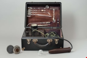
violet ray generator kit
https://search.heritageburnaby.ca/link/museumartifact5622
- Repository
- Burnaby Village Museum
- Accession Code
- BV986.20.2
- Description
- Violet ray generator; box is black, silver corners, hinged lid, two hinged snap closures, black handle; inside lid is brown velvet with silver holders for glass tube attachments; plaque "CHAS.A.BRANSTON LIMITED"; in box left side is voltage dial, three black control knobs; right side is compartment for two cords, one with plug end, other with hollow brown bakelite? handle; with two discs on handles, two metal tubes, one roller with handle, metal rectangle, and red instruction booklet "THE BRANSTON VIOLET RAY HIGH FREQUENCY GENERATOR", illustrated; c. 1928
- Object History
- This is a Branston Violet Ray Generator. Branston’s claims were similar to those of other Violet Ray makers. Treatments are given for over a hundred ailments, ranging from abscess through appendicitis, colitis, diabetes, glaucoma, gonorrhoea, haemmorrhoids, impotence, laryngitis, mumps, pyorrhea, tuberculosis, ulcers, wrinkles and even writer’s cramp. Electrical medical devices like this one were popular for decades among physicians, irregular practitioners, and home users, who could purchase them through catalogs and drugstores. The machine plugs into an electrical wall outlet. A glass electrode plugs into the wand, produces a violet glow, and delivers a spark when touched to the skin. The strength of the spark, controlled by the voltage selector, ranges from mild to quite intense. Attachments could stimulate many body parts.
- Classification
- Energy Production T&E - - Other Energy Production T&E
- Object Term
- Generator
- Historic Neighbourhood
- Central Park (Historic Neighbourhood)
- Planning Study Area
- Douglas-Gilpin Area
Images

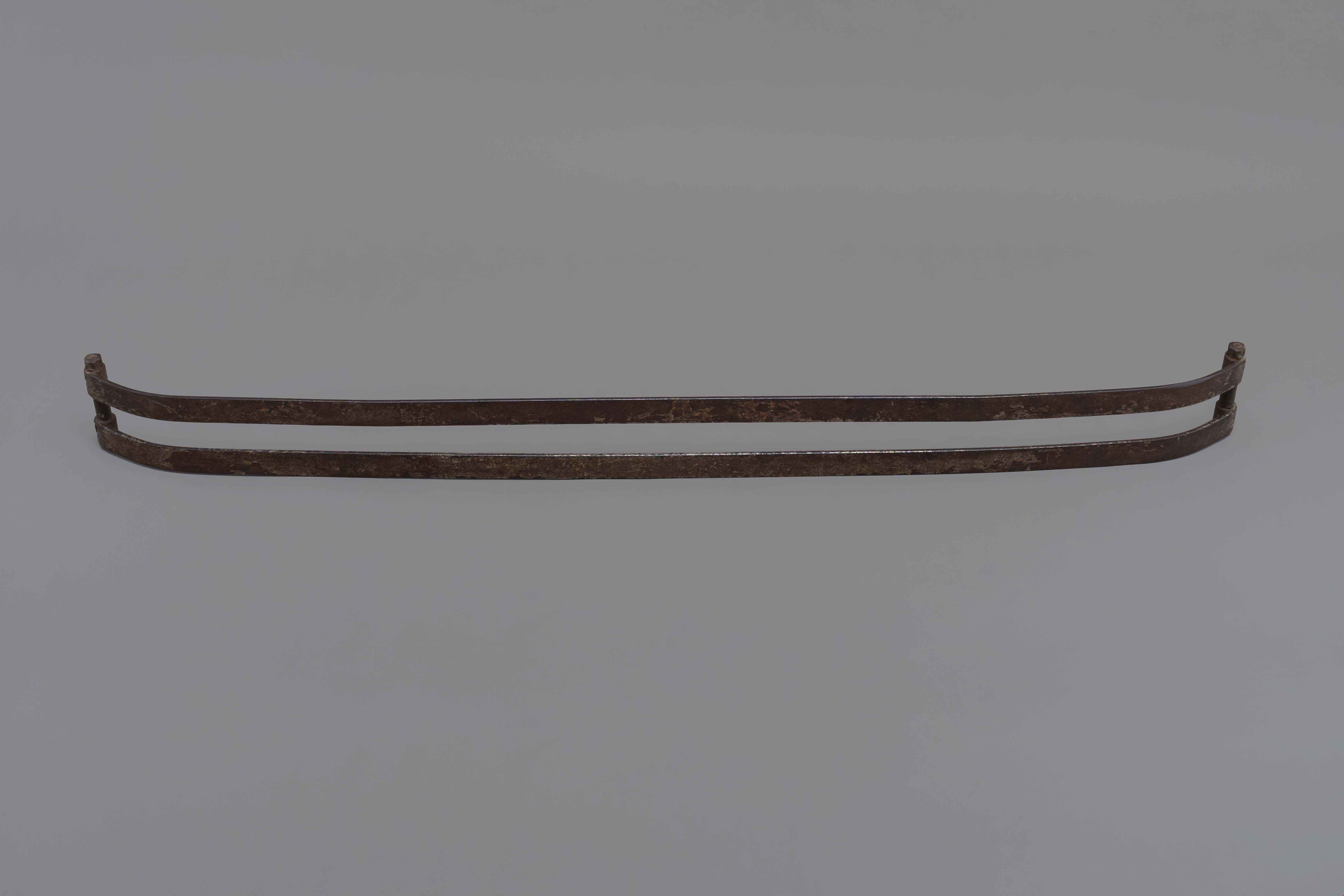
Bumper
https://search.heritageburnaby.ca/link/museumartifact9714
- Repository
- Burnaby Village Museum
- Accession Code
- BV985.2075.1
- Description
- Chevy bumper for automobile, rusted.
- Object History
- Bumper of this type was sold at Wagner's shop in his fleet of bumpers but was not the style he patented. This item can be seen in the blacksmith's shop at Burnaby Village Museum.
- Subjects
- Transportation - Automobiles
- Names
- Wagner, Frank
- Historic Neighbourhood
- Central Park (Historic Neighbourhood)
- Planning Study Area
- Maywood Area
Images
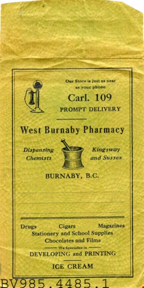
envelope
https://search.heritageburnaby.ca/link/museumartifact13092
- Repository
- Burnaby Village Museum
- Accession Code
- BV985.4485.1
- Description
- West Burnaby Pharmacy - Envelope. Olive green envelope from the West Burnaby Pharmacy on Kingsway and Sussex. The envelope has the store delivery number posted on the top for "Prompt Delivery". The pharmacy sells drugs, cigars, magazines, stationary and school supplies, chocolate, films and ice cream. There is also a developing and printing service. The envelope has two illustrations printed on it, one of a telephone in the top left corner and one of a mortar and pestle in the middle. The envelope measures 20cm (including flap) x 10cm.
- Classification
- Written Communication T&E - - Writing Accessories
- Object Term
- Envelope, Shipping
- Names
- West Burnaby Pharmacy
- Geographic Access
- Kingsway
- Street Address
- 4687 Kingsway
- Historic Neighbourhood
- Central Park (Historic Neighbourhood)
Images
