Narrow Results By
Subject
- Buildings - Civic 1
- Buildings - Commercial 2
- Buildings - Commercial - Banks 6
- Buildings - Commercial - Drugstores 3
- Buildings - Commercial - Malls 1
- Buildings - Commercial - Train Stations 1
- Buildings - Heritage 13
- Buildings - Industrial 1
- Buildings - Recreational - Community Halls 1
- Buildings - Religious 12
- Buildings - Religious - Churches 1
- Buildings - Schools - Universities and Colleges 1

6113 Silver Avenue lot
https://search.heritageburnaby.ca/link/archivedescription37775
- Repository
- City of Burnaby Archives
- Date
- 1986 (date of original), copied 1991
- Collection/Fonds
- Burnaby Historical Society fonds
- Description Level
- Item
- Physical Description
- 1 photograph : b&w ; 3.1 x 4.4 cm print on contact sheet 20.3 x 26.2 cm
- Scope and Content
- Photograph of the lot at 6113 Silver Avenue, the former home of the Ellis family. The house has been demolished and an empty lot remains. Houses, aparment buildings, and the Expo line skytrain track with cars on it can be seen in the background.
- Repository
- City of Burnaby Archives
- Date
- 1986 (date of original), copied 1991
- Collection/Fonds
- Burnaby Historical Society fonds
- Subseries
- Burnaby Image Bank subseries
- Physical Description
- 1 photograph : b&w ; 3.1 x 4.4 cm print on contact sheet 20.3 x 26.2 cm
- Description Level
- Item
- Record No.
- 370-363
- Access Restriction
- No restrictions
- Reproduction Restriction
- No restrictions
- Accession Number
- BHS1999-03
- Scope and Content
- Photograph of the lot at 6113 Silver Avenue, the former home of the Ellis family. The house has been demolished and an empty lot remains. Houses, aparment buildings, and the Expo line skytrain track with cars on it can be seen in the background.
- Subjects
- Land Clearing
- Media Type
- Photograph
- Notes
- Title based on contents of photograph
- 1 b&w copy negative accompanying
- Negative has a pink cast
- Copied from col. photograph
- Geographic Access
- Silver Avenue
- Street Address
- 6113 Silver Avenue
- Historic Neighbourhood
- Central Park (Historic Neighbourhood)
- Planning Study Area
- Maywood Area
Images


Bonsor Hall
https://search.heritageburnaby.ca/link/archivedescription38282
- Repository
- City of Burnaby Archives
- Date
- 1986
- Collection/Fonds
- Burnaby Historical Society fonds
- Description Level
- Item
- Physical Description
- 1 photograph : col. ; 10 x 13 cm
- Scope and Content
- Photograph of the Bonsor Hall (originally 6637 Fern Avenue). In the foreground, construction debris can be seen and the skytrain is visible in the background. A note with this photograph indicates that this building was originally the Burnaby School Board Office.
- Repository
- City of Burnaby Archives
- Date
- 1986
- Collection/Fonds
- Burnaby Historical Society fonds
- Subseries
- Photographs subseries
- Physical Description
- 1 photograph : col. ; 10 x 13 cm
- Description Level
- Item
- Record No.
- 386-001
- Access Restriction
- No restrictions
- Reproduction Restriction
- Reproduce for fair dealing purposes only
- Accession Number
- BHS2007-04
- Scope and Content
- Photograph of the Bonsor Hall (originally 6637 Fern Avenue). In the foreground, construction debris can be seen and the skytrain is visible in the background. A note with this photograph indicates that this building was originally the Burnaby School Board Office.
- Names
- Bonsor Hall
- Media Type
- Photograph
- Notes
- Title based on contents of photograph.
- Geographic Access
- Fern Avenue
- Historic Neighbourhood
- Central Park (Historic Neighbourhood)
- Planning Study Area
- Marlborough Area
Images


Central Park Entrance
https://search.heritageburnaby.ca/link/archivedescription34860
- Repository
- City of Burnaby Archives
- Date
- March 23, 1985
- Collection/Fonds
- Burnaby Historical Society fonds
- Description Level
- Item
- Physical Description
- 1 photograph : col. ; 8.8 x 11.3 cm
- Scope and Content
- Photograph of the Central Park entrance on Kingsway. A car can be seen exiting the park, and the tracks of the Skytrain Expo line are in the background.
- Repository
- City of Burnaby Archives
- Date
- March 23, 1985
- Collection/Fonds
- Burnaby Historical Society fonds
- Subseries
- Evelyn Salisbury subseries
- Physical Description
- 1 photograph : col. ; 8.8 x 11.3 cm
- Description Level
- Item
- Record No.
- 145-008
- Access Restriction
- No restrictions
- Reproduction Restriction
- Reproduce for fair dealing purposes only
- Accession Number
- BHS1985-15
- Scope and Content
- Photograph of the Central Park entrance on Kingsway. A car can be seen exiting the park, and the tracks of the Skytrain Expo line are in the background.
- Subjects
- Structures - Arches
- Media Type
- Photograph
- Notes
- Title based on contents of photograph
- Geographic Access
- Central Park
- Imperial Street
- Street Address
- 3883 Imperial Street
- Historic Neighbourhood
- Central Park (Historic Neighbourhood)
- Planning Study Area
- Maywood Area
Images


Central Park Entrance
https://search.heritageburnaby.ca/link/archivedescription34861
- Repository
- City of Burnaby Archives
- Date
- March 23, 1985
- Collection/Fonds
- Burnaby Historical Society fonds
- Description Level
- Item
- Physical Description
- 1 photograph : col. ; 8.8 x 11.3 cm
- Scope and Content
- Photograph of the Central Park entrance on Kingsway. The tracks of the Skytrain Expo line can be seen in the background.
- Repository
- City of Burnaby Archives
- Date
- March 23, 1985
- Collection/Fonds
- Burnaby Historical Society fonds
- Subseries
- Evelyn Salisbury subseries
- Physical Description
- 1 photograph : col. ; 8.8 x 11.3 cm
- Description Level
- Item
- Record No.
- 145-009
- Access Restriction
- No restrictions
- Reproduction Restriction
- Reproduce for fair dealing purposes only
- Accession Number
- BHS1985-15
- Scope and Content
- Photograph of the Central Park entrance on Kingsway. The tracks of the Skytrain Expo line can be seen in the background.
- Subjects
- Structures - Arches
- Media Type
- Photograph
- Notes
- Title based on contents of photograph
- Geographic Access
- Central Park
- Imperial Street
- Street Address
- 3883 Imperial Street
- Historic Neighbourhood
- Central Park (Historic Neighbourhood)
- Planning Study Area
- Maywood Area
Images


Central Park Pharmacy
https://search.heritageburnaby.ca/link/archivedescription35024
- Repository
- City of Burnaby Archives
- Date
- July 1986
- Collection/Fonds
- Burnaby Historical Society fonds
- Description Level
- Item
- Physical Description
- 1 photograph : b&w ; 8.8 x 12.5 cm
- Scope and Content
- Photograph of the exterior of the Central Park Pharmacy and Post Office, 3967 Kingsway at Jersey Avenue. Signs read, "Central Park Pharmacy," "Post Office," and "Drugs." A view east down Kingsway can be seen on the right side of the photo. There is an automobile parked on the street, a firehydra…
- Repository
- City of Burnaby Archives
- Date
- July 1986
- Collection/Fonds
- Burnaby Historical Society fonds
- Subseries
- Evelyn Salisbury subseries
- Physical Description
- 1 photograph : b&w ; 8.8 x 12.5 cm
- Description Level
- Item
- Record No.
- 177-001
- Access Restriction
- No restrictions
- Reproduction Restriction
- Reproduce for fair dealing purposes only
- Accession Number
- BHS1986-25
- Scope and Content
- Photograph of the exterior of the Central Park Pharmacy and Post Office, 3967 Kingsway at Jersey Avenue. Signs read, "Central Park Pharmacy," "Post Office," and "Drugs." A view east down Kingsway can be seen on the right side of the photo. There is an automobile parked on the street, a firehydrant in the left corner of the photo, and apartment buildings in the background.
- Subjects
- Buildings - Commercial - Drugstores
- Names
- Central Park Pharmacy
- Media Type
- Photograph
- Notes
- Title based on contents of photograph
- Geographic Access
- Kingsway
- Jersey Avenue
- Street Address
- 3967 Kingsway
- Historic Neighbourhood
- Central Park (Historic Neighbourhood)
- Planning Study Area
- Garden Village Area
Images


Central Park Pharmacy
https://search.heritageburnaby.ca/link/archivedescription35025
- Repository
- City of Burnaby Archives
- Date
- July 1986
- Collection/Fonds
- Burnaby Historical Society fonds
- Description Level
- Item
- Physical Description
- 1 photograph : b&w ; 8.8 x 12.5 cm
- Scope and Content
- Photograph of the Central Park Pharmacy and Post Office, 3967 Kingsway at Jersey Avenue. A view north up Jersey Avenue can be seen at the left side of the photograph, and Kingsway can be seen at the front and right side of the photo. Signs read, "Central Park Pharmacy," "Drugs," and "Central Park…
- Repository
- City of Burnaby Archives
- Date
- July 1986
- Collection/Fonds
- Burnaby Historical Society fonds
- Subseries
- Evelyn Salisbury subseries
- Physical Description
- 1 photograph : b&w ; 8.8 x 12.5 cm
- Description Level
- Item
- Record No.
- 177-002
- Access Restriction
- No restrictions
- Reproduction Restriction
- Reproduce for fair dealing purposes only
- Accession Number
- BHS1986-25
- Scope and Content
- Photograph of the Central Park Pharmacy and Post Office, 3967 Kingsway at Jersey Avenue. A view north up Jersey Avenue can be seen at the left side of the photograph, and Kingsway can be seen at the front and right side of the photo. Signs read, "Central Park Pharmacy," "Drugs," and "Central Park." Automobiles and a truck are parked on the street. The north shore mountains can be seen in the background.
- Subjects
- Buildings - Commercial - Drugstores
- Names
- Central Park Pharmacy
- Media Type
- Photograph
- Notes
- Title based on contents of photograph
- Geographic Access
- Kingsway
- Jersey Avenue
- Street Address
- 3967 Kingsway
- Historic Neighbourhood
- Central Park (Historic Neighbourhood)
- Planning Study Area
- Garden Village Area
Images


Central Park Pharmacy
https://search.heritageburnaby.ca/link/archivedescription35026
- Repository
- City of Burnaby Archives
- Date
- July 1986
- Collection/Fonds
- Burnaby Historical Society fonds
- Description Level
- Item
- Physical Description
- 1 photograph : b&w ; 12.5 x 8.8 cm
- Scope and Content
- Photograph of the Central Park Pharmacy and Post Office, 3967 Kingsway at Jersey Avenue, with Mr. Chan, the pharmacist, standing outside. Some of the signs on the store read, "Central Park Pharmacy," "Post Office," "Drugs," "Visa," and "On Sale Here." A view east down Kingsway can be seen on the …
- Repository
- City of Burnaby Archives
- Date
- July 1986
- Collection/Fonds
- Burnaby Historical Society fonds
- Subseries
- Evelyn Salisbury subseries
- Physical Description
- 1 photograph : b&w ; 12.5 x 8.8 cm
- Description Level
- Item
- Record No.
- 177-003
- Access Restriction
- No restrictions
- Reproduction Restriction
- Reproduce for fair dealing purposes only
- Accession Number
- BHS1986-25
- Scope and Content
- Photograph of the Central Park Pharmacy and Post Office, 3967 Kingsway at Jersey Avenue, with Mr. Chan, the pharmacist, standing outside. Some of the signs on the store read, "Central Park Pharmacy," "Post Office," "Drugs," "Visa," and "On Sale Here." A view east down Kingsway can be seen on the right side of the photograph. Cars are visible on the street. A sign further down Kingsway reads, "TV: Tele-Peter." The street sign reads, "Jersey Ave 5600."
- Names
- Central Park Pharmacy
- Media Type
- Photograph
- Notes
- Title based on contents of photograph
- Geographic Access
- Kingsway
- Jersey Avenue
- Street Address
- 3967 Kingsway
- Historic Neighbourhood
- Central Park (Historic Neighbourhood)
- Planning Study Area
- Garden Village Area
Images

![Central Park Pitch 'n Putt, [between 1968 and 1988] thumbnail](/media/hpo/_Data/_Archives_Images/_Unrestricted/205/222-028.jpg?width=280)
Central Park Pitch 'n Putt
https://search.heritageburnaby.ca/link/archivedescription36105
- Repository
- City of Burnaby Archives
- Date
- [between 1968 and 1988]
- Collection/Fonds
- Burnaby Historical Society fonds
- Description Level
- Item
- Physical Description
- 1 photograph : b&w ; 19 x 24 cm
- Scope and Content
- Photograph of a man crouching down to watch as a young girl aims her puttter at the Central Park Pitch n' Putt golf course.
- Repository
- City of Burnaby Archives
- Date
- [between 1968 and 1988]
- Collection/Fonds
- Burnaby Historical Society fonds
- Subseries
- Columbian Newspaper subseries
- Physical Description
- 1 photograph : b&w ; 19 x 24 cm
- Description Level
- Item
- Record No.
- 222-028
- Access Restriction
- No restrictions
- Reproduction Restriction
- Reproduce for fair dealing purposes only
- Accession Number
- BHS1989-19
- Scope and Content
- Photograph of a man crouching down to watch as a young girl aims her puttter at the Central Park Pitch n' Putt golf course.
- Subjects
- Geographic Features - Parks
- Media Type
- Photograph
- Photographer
- King, Basil
- Notes
- Title based on contents of photograph
- Geographic Access
- Central Park
- Imperial Street
- Street Address
- 3883 Imperial Street
- Historic Neighbourhood
- Central Park (Historic Neighbourhood)
- Planning Study Area
- Maywood Area
Images
![Central Park Pitch 'n Putt, [between 1968 and 1988] thumbnail](/media/hpo/_Data/_Archives_Images/_Unrestricted/205/222-028.jpg)

Empty lot
https://search.heritageburnaby.ca/link/archivedescription38283
- Repository
- City of Burnaby Archives
- Date
- 1987
- Collection/Fonds
- Burnaby Historical Society fonds
- Description Level
- Item
- Physical Description
- 1 photograph : col. ; 8.9 x 11 cm
- Scope and Content
- Photograph of the site of Bonsor Hall, on Fern Avenue, after demolition. A blue car is visible.
- Repository
- City of Burnaby Archives
- Date
- 1987
- Collection/Fonds
- Burnaby Historical Society fonds
- Subseries
- Photographs subseries
- Physical Description
- 1 photograph : col. ; 8.9 x 11 cm
- Description Level
- Item
- Record No.
- 386-002
- Access Restriction
- No restrictions
- Reproduction Restriction
- Reproduce for fair dealing purposes only
- Accession Number
- BHS2007-04
- Scope and Content
- Photograph of the site of Bonsor Hall, on Fern Avenue, after demolition. A blue car is visible.
- Subjects
- Transportation - Automobiles
- Media Type
- Photograph
- Notes
- Title based on contents of photograph
- Geographic Access
- Fern Avenue
- Historic Neighbourhood
- Central Park (Historic Neighbourhood)
- Planning Study Area
- Marlborough Area
Images


Former site of the Kelly Douglas building
https://search.heritageburnaby.ca/link/archivedescription35027
- Repository
- City of Burnaby Archives
- Date
- August 18, 1986
- Collection/Fonds
- Burnaby Historical Society fonds
- Description Level
- Item
- Physical Description
- 1 photograph : col. ; 8.8 x 12.6 cm
- Scope and Content
- Photograph of the site of Kelly Douglas and Co. at 4700 Kingsway after the building was demolished. A bulldozer and a large truck with two men standing on it are at the back left of the photograph.
- Repository
- City of Burnaby Archives
- Date
- August 18, 1986
- Collection/Fonds
- Burnaby Historical Society fonds
- Subseries
- Evelyn Salisbury subseries
- Physical Description
- 1 photograph : col. ; 8.8 x 12.6 cm
- Material Details
- Printed on verso of photograph: "This paper manufactured by Kodak"
- Description Level
- Item
- Record No.
- 178-001
- Access Restriction
- No restrictions
- Reproduction Restriction
- Reproduce for fair dealing purposes only
- Accession Number
- BHS1986-26
- Scope and Content
- Photograph of the site of Kelly Douglas and Co. at 4700 Kingsway after the building was demolished. A bulldozer and a large truck with two men standing on it are at the back left of the photograph.
- Media Type
- Photograph
- Notes
- Title based on contents of photograph
- Geographic Access
- Kingsway
- Street Address
- 4700 Kingsway
- Historic Neighbourhood
- Central Park (Historic Neighbourhood)
- Planning Study Area
- Maywood Area
Images


Former site of the Kelly Douglas building
https://search.heritageburnaby.ca/link/archivedescription35028
- Repository
- City of Burnaby Archives
- Date
- August 18, 1986
- Collection/Fonds
- Burnaby Historical Society fonds
- Description Level
- Item
- Physical Description
- 1 photograph : col. ; 8.8 x 12.6 cm
- Scope and Content
- Photograph of the site of Kelly Douglas and Co. at 4700 Kingsway after the building was demolished. Buildings and the Skytrain Expo line are visible in the background.
- Repository
- City of Burnaby Archives
- Date
- August 18, 1986
- Collection/Fonds
- Burnaby Historical Society fonds
- Subseries
- Evelyn Salisbury subseries
- Physical Description
- 1 photograph : col. ; 8.8 x 12.6 cm
- Description Level
- Item
- Record No.
- 178-002
- Access Restriction
- No restrictions
- Reproduction Restriction
- Reproduce for fair dealing purposes only
- Accession Number
- BHS1986-26
- Scope and Content
- Photograph of the site of Kelly Douglas and Co. at 4700 Kingsway after the building was demolished. Buildings and the Skytrain Expo line are visible in the background.
- Media Type
- Photograph
- Notes
- Title based on contents of photograph
- Geographic Access
- Kingsway
- Street Address
- 4700 Kingsway
- Historic Neighbourhood
- Central Park (Historic Neighbourhood)
- Planning Study Area
- Maywood Area
Images


Interview with Don Brown by Rod Fowler February 26, 1990 - Track 8
https://search.heritageburnaby.ca/link/oralhistory509
- Repository
- City of Burnaby Archives
- Date Range
- 1947-1990
- Length
- 00:11:47
- Summary
- This portion of the interview is about Don Brown identifying old businesses and stores on Kingsway, and talking about the operation of the interurban, the lack of cars after the war, and the two vehicles used by the Burnaby police in 1948. He talks about the expansion of Burnaby in the 1950‘s and t…
- Repository
- City of Burnaby Archives
- Summary
- This portion of the interview is about Don Brown identifying old businesses and stores on Kingsway, and talking about the operation of the interurban, the lack of cars after the war, and the two vehicles used by the Burnaby police in 1948. He talks about the expansion of Burnaby in the 1950‘s and the attempts to preserve heritage buildings and trees, historic records, and green space
- Date Range
- 1947-1990
- Photo Info
- Royal Canadian Mounted Police Sergeant Don Brown, November 2, 1997. Item no. 535-0979
- Length
- 00:11:47
- Historic Neighbourhood
- Central Park (Historic Neighbourhood)
- Planning Study Area
- Marlborough Area
- Maywood Area
- Interviewer
- Fowler, Rod
- Interview Date
- February 26, 1990
- Scope and Content
- Recording is of an interview with Don Brown, conducted by Rod Fowler. Don Brown was one of eleven participants interviewed as part of the SFU/Burnaby Centennial Committee's oral history series titled, "Voices of Burnaby". The interview is mainly about Don Brown’s description of the changes in Burnaby’s built and natural landscapes and socioeconomic conditions, especially between 1947 and 1975, the strong impression made on him by those changes evident in the interview. He talks about his work and career as a police officer with the Burnaby Provincial Police and RCMP. The interview also details his involvement in Burnaby politics and volunteer community groups. To view “Narrow By” terms for each track expand this description and see “Notes”.
- Biographical Notes
- Donald Neil “Don” Brown was born in Birmingham, England May 4, 1919, and immigrated with his parents and siblings to Winnipeg in 1922. At the outbreak of WWII Don Brown left high school and enlisted in the 12th Field Company, Royal Canadian Engineers, serving six years in the army. Before going overseas he married Helen Birch in 1939. In 1947 Don Brown joined the B.C. Provincial Police which was absorbed by the RCMP in 1950. He worked as a police officer in Burnaby from 1947 to 1954, and then was transferred to Ottawa (with a stop in Regina) for nine and a half years where he attended Carleton University to study forensics. In 1963 Don Brown was transferred back to Vancouver and bought and moved into a house on Watling Street in Burnaby where he still lived in 1990. Another transfer took him to Edmonton for five years, returning to Burnaby in 1975. Following retirement in 1980 with the rank of Supervisor and after 22 years in forensic laboratories, Don Brown started his own business as a private document examiner. Don Brown was active in Burnaby politics, serving as Alderman from 1979-1985. He was also involved in many community groups including the South Burnaby Men’s Club, which he helped found in 1952, as well as active in the Burnaby Historical Society, and served on the Burnaby School Board, Burnaby Centennial Committee, and the Community College for the Retired. Don and Helen Brown had six children: Donna, Don, Gina, Patricia, Christopher and Susan. Don Brown died May 16, 2009.
- Total Tracks
- 14
- Total Length
- 01:35:07
- Interviewee Name
- Brown, Donald N. "Don"
- Interviewer Bio
- Rod Fowler returned to university as a mature student in the 1980s after working about twenty years in the field of economics and computerization in business in England, Europe and Western Canada. He graduated with a BA from SFU in both History and Sociology in 1987, his MA degree in Geography in 1989, and his PhD in Cultural Geography at SFU. He taught courses in Geography, Sociology, History and Canadian Studies at several Lower Mainland colleges, before becoming a full time member of the Geography Department at Kwantlen University College.
- Collection/Fonds
- SFU/Burnaby Centennial Committee fonds
- Transcript Available
- Transcript available
- Media Type
- Sound Recording
- Web Notes
- Interviews were digitized in 2015 allowing them to be accessible on Heritage Burnaby. The digitization project was initiated by the Community Heritage Commission with support from City of Burnaby Council.
Images

Audio Tracks
Track eight of interview with Don Brown
Track eight of interview with Don Brown
https://search.heritageburnaby.ca/media/hpo/_Data/_Archives_Oral_Histories/_Unrestricted/MSS187-016/MSS187-016_Track%208.mp3
Interview with Sev Morin by Rod Fowler April 4, 1990 - Track 2
https://search.heritageburnaby.ca/link/oralhistory538
- Repository
- City of Burnaby Archives
- Date Range
- 1950-1990
- Length
- 00:06:16
- Summary
- This portion of the interview is about Sev Morin’s description of Burnaby’s growth and business development along Kingsway and Hastings, the Lake City Industrial Park, and the purchase of property in 1958 for the Heritage Park and Art Gallery.
- Repository
- City of Burnaby Archives
- Summary
- This portion of the interview is about Sev Morin’s description of Burnaby’s growth and business development along Kingsway and Hastings, the Lake City Industrial Park, and the purchase of property in 1958 for the Heritage Park and Art Gallery.
- Date Range
- 1950-1990
- Photo Info
- Sev Morin (left) of Severin's in Burnaby (formerly the Gai Paree) hosting a gala New Year's celebration, 1979. Item no. 480-712
- Length
- 00:06:16
- Subjects
- Buildings - Commercial
- Buildings - Civic
- Buildings - Industrial
- Buildings - Schools - Universities and Colleges
- Historic Neighbourhood
- Central Park (Historic Neighbourhood)
- Burnaby Lake (Historic Neighbourhood)
- Vancouver Heights (Historic Neighbourhood)
- Edmonds (Historic Neighbourhood)
- Planning Study Area
- Burnaby Heights Area
- Lake City Area
- Burnaby Mountain Area
- Kingsway-Beresford Area
- Douglas-Gilpin Area
- Interviewer
- Fowler, Rod
- Interview Date
- April 4, 1990
- Scope and Content
- Recording is of an interview with Severin "Sev" Morin, conducted by Rod Fowler. Sev Morin was one of eleven participants interviewed as part of the SFU/Burnaby Centennial Committee's oral history series titled, "Voices of Burnaby". The interview is mainly about Sev Morin’s banquet hall, restaurant and night club business on Kingsway, originally named the “Gai Paree Supper Club” (1947-1976) and later “Severin’s” (1976-1985) and “Diego’s” (1985-1994), its function as a Burnaby landmark, and the entertainment and political people he met through his business. He also describes his many volunteer activities in Burnaby, including member of the SFU Senate, Rotary Club, Variety Club and Telethon, fund raising for Burnaby Hospital, and tourism related groups, and his political work for the federal Liberal party. He talks about his parents’ origins, the lives of his brothers Rudy and Rene, and the family’s involvement in establishing the “Gai Paree”. He also shares his views about the business and cultural development of Burnaby. To view “Narrow By” terms for each track expand this description and see “Notes”.
- Biographical Notes
- Severin “Sev” Rene Morin was born September 21, 1927, in Bonneville, Alberta, to Rene Pierre Morin (1878-1963) and Anne Marie (nee Lachiver) Morin (1886-1956). Mr. and Mrs. R. P. Morin and their son Rene Francois (1905-1954) immigrated to Edmonton, Alberta, from France in 1913, where Rene Pierre Morin worked for the C.N.R. and a second son Adolphe “Rudy” Ferdinand (1922-1969) was born, followed by their third son Severin. In 1943, after R.P. Morin retired, the family moved to Burnaby to a house on Sperling Avenue. Sometime earlier the two older Morin brothers found work in Trail at the smelter and developed musical careers. In 1946/47 the Morin family purchased property on Kingsway and built a banquet hall, the “Gai Paree Supper Club”. Sev and Rudy Morin managed the club and Rene F. Morin moved to Burnaby to join them with his band. The supper club, with its live music and dance floor, became a popular meeting place and wedding venue, eventually expanding into a restaurant and nightclub in the 1970s. The “Gai Paree” was renamed “Severin’s” in 1976 and “Diego’s” in 1985, closing finally in 1994. Sev Morin’s business life included three record stores which he owned with his friend Jack Cullen. Through these businesses Sev Morin was well known in the entertainment and hospitality industry. He and his restaurant also hosted political and social events that made the restaurant a community landmark. Sev Morin contributed many volunteer hours to community and charitable organizations, including an appointment to the SFU Senate, fundraising for the Burnaby Hospital, Director of the Variety Club and Rotary Club, and consultant for a variety of tourism related ventures. He also was active in the federal Liberal Party. Sev Morin and his wife Pauline married in 1950 and had three children. Sev Morin died at age 86 on March 28, 2014.
- Total Tracks
- 10
- Total Length
- 00:56:44
- Interviewee Name
- Morin, Severin "Sev"
- Interviewer Bio
- Rod Fowler returned to university as a mature student in the 1980s after working about twenty years in the field of economics and computerization in business in England, Europe and Western Canada. He graduated with a BA from SFU in both History and Sociology in 1987, his MA degree in Geography in 1989, and his PhD in Cultural Geography at SFU. He taught courses in Geography, Sociology, History and Canadian Studies at several Lower Mainland colleges, before becoming a full time member of the Geography Department at Kwantlen University College.
- Collection/Fonds
- SFU/Burnaby Centennial Committee fonds
- Transcript Available
- Transcript available
- Media Type
- Sound Recording
- Web Notes
- Interviews were digitized in 2015 allowing them to be accessible on Heritage Burnaby. The digitization project was initiated by the Community Heritage Commission with support from City of Burnaby Council.
Images

Audio Tracks
Track two of interview with Sev Morin
Track two of interview with Sev Morin
https://search.heritageburnaby.ca/media/hpo/_Data/_Archives_Oral_Histories/_Unrestricted/MSS187-021/MSS187-021_Track%202.mp3
Jubilee Arch
https://search.heritageburnaby.ca/link/archivedescription34858
- Repository
- City of Burnaby Archives
- Date
- March 7, 1985
- Collection/Fonds
- Burnaby Historical Society fonds
- Description Level
- Item
- Physical Description
- 1 photograph : col. ; 8.8 x 11.4 cm
- Scope and Content
- Photograph of the back of the Central Park Arch at Patterson Avenue and Kingsway.
- Repository
- City of Burnaby Archives
- Date
- March 7, 1985
- Collection/Fonds
- Burnaby Historical Society fonds
- Subseries
- Evelyn Salisbury subseries
- Physical Description
- 1 photograph : col. ; 8.8 x 11.4 cm
- Description Level
- Item
- Record No.
- 145-006
- Access Restriction
- No restrictions
- Reproduction Restriction
- Reproduce for fair dealing purposes only
- Accession Number
- BHS1985-15
- Scope and Content
- Photograph of the back of the Central Park Arch at Patterson Avenue and Kingsway.
- Media Type
- Photograph
- Notes
- Title based on contents of photograph
- Geographic Access
- Central Park
- Imperial Street
- Street Address
- 3883 Imperial Street
- Historic Neighbourhood
- Central Park (Historic Neighbourhood)
- Planning Study Area
- Maywood Area
Images


Jubilee Arch
https://search.heritageburnaby.ca/link/archivedescription34859
- Repository
- City of Burnaby Archives
- Date
- March 7, 1985
- Collection/Fonds
- Burnaby Historical Society fonds
- Description Level
- Item
- Physical Description
- 1 photograph : col. ; 8.8 x 11.3 cm
- Scope and Content
- Photograph of the front of the Central Park Arch at Patterson Avenue and Kingsway.
- Repository
- City of Burnaby Archives
- Date
- March 7, 1985
- Collection/Fonds
- Burnaby Historical Society fonds
- Subseries
- Evelyn Salisbury subseries
- Physical Description
- 1 photograph : col. ; 8.8 x 11.3 cm
- Description Level
- Item
- Record No.
- 145-007
- Access Restriction
- No restrictions
- Reproduction Restriction
- Reproduce for fair dealing purposes only
- Accession Number
- BHS1985-15
- Scope and Content
- Photograph of the front of the Central Park Arch at Patterson Avenue and Kingsway.
- Media Type
- Photograph
- Notes
- Title based on contents of photograph
- Geographic Access
- Central Park
- Imperial Street
- Street Address
- 3883 Imperial Street
- Historic Neighbourhood
- Central Park (Historic Neighbourhood)
- Planning Study Area
- Maywood Area
Images

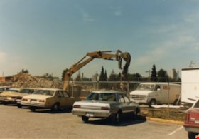
Kelly Douglas building
https://search.heritageburnaby.ca/link/archivedescription35029
- Repository
- City of Burnaby Archives
- Date
- August 18, 1986
- Collection/Fonds
- Burnaby Historical Society fonds
- Description Level
- Item
- Physical Description
- 1 photograph : col. ; 8.8 x 12.6 cm
- Scope and Content
- Photograph of the site of Kelly Douglas and Co. at 4700 Kingsway after the building was demolished. An excavator is working on the site. Cars are parked outside a fence, and a van lettered, "ATCO," is inside the fence.
- Repository
- City of Burnaby Archives
- Date
- August 18, 1986
- Collection/Fonds
- Burnaby Historical Society fonds
- Subseries
- Evelyn Salisbury subseries
- Physical Description
- 1 photograph : col. ; 8.8 x 12.6 cm
- Description Level
- Item
- Record No.
- 178-003
- Access Restriction
- No restrictions
- Reproduction Restriction
- Reproduce for fair dealing purposes only
- Accession Number
- BHS1986-26
- Scope and Content
- Photograph of the site of Kelly Douglas and Co. at 4700 Kingsway after the building was demolished. An excavator is working on the site. Cars are parked outside a fence, and a van lettered, "ATCO," is inside the fence.
- Subjects
- Construction Tools and Equipment
- Media Type
- Photograph
- Notes
- Title based on contents of photograph
- Geographic Access
- Kingsway
- Street Address
- 4700 Kingsway
- Historic Neighbourhood
- Central Park (Historic Neighbourhood)
- Planning Study Area
- Maywood Area
Images

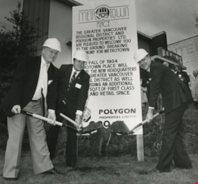
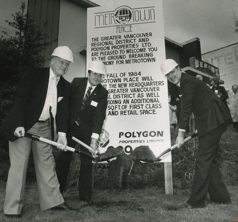
Mayor Bill Lewarne, Jim Tonn and Michael Audain
https://search.heritageburnaby.ca/link/archivedescription45386
- Repository
- City of Burnaby Archives
- Date
- 1983
- Collection/Fonds
- Columbian Newspaper collection
- Description Level
- Item
- Physical Description
- 1 photograph : b&w ; 19 x 20.5 cm
- Scope and Content
- Photograph of Burnaby Mayor Bill Lewarne, Jim Tonn from the Greater Vancouver Regional District (now Metro Vancouver), and the President of Polygon Michael Audain each with a shovel full of dirt at the ground breaking ceremony for Metrotown Place, the new headquaters for the Greater Vancouver Regio…
- Repository
- City of Burnaby Archives
- Date
- 1983
- Collection/Fonds
- Columbian Newspaper collection
- Physical Description
- 1 photograph : b&w ; 19 x 20.5 cm
- Description Level
- Item
- Record No.
- 480-281
- Access Restriction
- No restrictions
- Reproduction Restriction
- No restrictions
- Accession Number
- 2003-02
- Scope and Content
- Photograph of Burnaby Mayor Bill Lewarne, Jim Tonn from the Greater Vancouver Regional District (now Metro Vancouver), and the President of Polygon Michael Audain each with a shovel full of dirt at the ground breaking ceremony for Metrotown Place, the new headquaters for the Greater Vancouver Regional District (now Metro Vancouver).
- Media Type
- Photograph
- Photographer
- Battistoni, Peter
- Notes
- Title based on contents of photograph
- Geographic Access
- Kingsway
- Street Address
- 4330 Kingsway
- Historic Neighbourhood
- Central Park (Historic Neighbourhood)
- Planning Study Area
- Maywood Area
Images

Metrotown Station Square
https://search.heritageburnaby.ca/link/archivedescription93745
- Repository
- City of Burnaby Archives
- Date
- November 1989
- Collection/Fonds
- Grover, Elliott & Co. Ltd. fonds
- Description Level
- File
- Physical Description
- 83 photographs : col. negatives ; 35 mm + 2 computer disks ; 14 x 14 cm
- Scope and Content
- Photographs of Metrotown Station Square during construction. Businesses visible in the photographs include: Eastons, Holiday Inn, Future Shop, Great Canadian Superstore, and Toy City Consumers.
- Repository
- City of Burnaby Archives
- Date
- November 1989
- Collection/Fonds
- Grover, Elliott & Co. Ltd. fonds
- Physical Description
- 83 photographs : col. negatives ; 35 mm + 2 computer disks ; 14 x 14 cm
- Description Level
- File
- Record No.
- 622-030
- Access Restriction
- No restrictions
- Reproduction Restriction
- No restrictions
- Accession Number
- 2017-39
- Scope and Content
- Photographs of Metrotown Station Square during construction. Businesses visible in the photographs include: Eastons, Holiday Inn, Future Shop, Great Canadian Superstore, and Toy City Consumers.
- Media Type
- Photograph
- Notes
- Transcribed title
- Title transcribed from print envelopes photographs were originally housed in
- File no. 89-512-B
- Computer disks are labelled "Station Square Metro Town Nov /89". Computer disk envelopes are labelled "Suite 660-1380 Burrard ST / Van, BC"
- Geographic Access
- McKay Avenue
- Street Address
- 6200 McKay Avenue
- Historic Neighbourhood
- Central Park (Historic Neighbourhood)
- Planning Study Area
- Maywood Area
Images

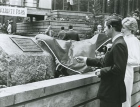
Prince Charles and Princess Diana
https://search.heritageburnaby.ca/link/archivedescription36619
- Repository
- City of Burnaby Archives
- Date
- 1986
- Collection/Fonds
- Burnaby Historical Society fonds
- Description Level
- Item
- Physical Description
- 1 photograph : b&w ; 18.5 x 24.5 cm
- Scope and Content
- Photograph of the Prince and Princess of Wales unveiling a plaque at Central Park.
- Repository
- City of Burnaby Archives
- Date
- 1986
- Collection/Fonds
- Burnaby Historical Society fonds
- Subseries
- Gavel Historical Society subseries
- Physical Description
- 1 photograph : b&w ; 18.5 x 24.5 cm
- Description Level
- Item
- Record No.
- 311-001
- Access Restriction
- No restrictions
- Reproduction Restriction
- Reproduce for fair dealing purposes only
- Accession Number
- BHS1994-03
- Scope and Content
- Photograph of the Prince and Princess of Wales unveiling a plaque at Central Park.
- Subjects
- Events - Royal Visits
- Ceremonies
- Media Type
- Photograph
- Photographer
- Harrison, Jim
- Notes
- Title based on contents of photograph
- Geographic Access
- Central Park
- Imperial Street
- Street Address
- 3883 Imperial Street
- Historic Neighbourhood
- Central Park (Historic Neighbourhood)
- Planning Study Area
- Maywood Area
Images

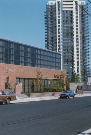
Royal Bank on Kingsway at Kathleen Avenue
https://search.heritageburnaby.ca/link/archivedescription36468
- Repository
- City of Burnaby Archives
- Date
- July 1985
- Collection/Fonds
- Burnaby Historical Society fonds
- Description Level
- Item
- Physical Description
- 1 photograph : col. ; 15 x 10 cm
- Scope and Content
- Photograph of the east side of Royal Bank building on Kingsway at Kathleen Avenue. The high-rise in the background is across Kingsway, on the north side. The bank moved two blocks east from McKay Avenue to this new location.
- Repository
- City of Burnaby Archives
- Date
- July 1985
- Collection/Fonds
- Burnaby Historical Society fonds
- Subseries
- Vera Jackson Pel subseries
- Physical Description
- 1 photograph : col. ; 15 x 10 cm
- Description Level
- Item
- Record No.
- 274-005
- Access Restriction
- No restrictions
- Reproduction Restriction
- Reproduce for fair dealing purposes only
- Accession Number
- BHS1992-04
- Scope and Content
- Photograph of the east side of Royal Bank building on Kingsway at Kathleen Avenue. The high-rise in the background is across Kingsway, on the north side. The bank moved two blocks east from McKay Avenue to this new location.
- Subjects
- Buildings - Commercial - Banks
- Names
- Royal Bank of Canada
- Media Type
- Photograph
- Notes
- Title based on contents of photograph
- Geographic Access
- Kathleen Avenue
- Kingsway
- Street Address
- 4370 Kingsway
- Historic Neighbourhood
- Central Park (Historic Neighbourhood)
- Planning Study Area
- Maywood Area
Images