Narrow Results By
Subject
- Advertising Medium 3
- Advertising Medium - Signs and Signboards 1
- Agriculture - Fruit and Berries 1
- Building Components 1
- Buildings - Commercial 1
- Buildings - Commercial - Restaurants 1
- Buildings - Schools 4
- Ceremonies - Awards 1
- Clothing 5
- Clothing - Costumes 3
- Construction Tools and Equipment 1
- Container - Box 2
postcard
https://search.heritageburnaby.ca/link/museumartifact84668
- Repository
- Burnaby Village Museum
- Accession Code
- BV007.43.1
- Description
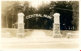
- postcard; black and white photograph of entrance arches to Central Park in Burnaby - [192-]. The postcard was published by the Gowen Sutton Company Limited of Vancouver, BC. Stamp in black ink on verso of postcard reads "PUBLISHED BY THE GOWEN SUTTON CO. LTD. VANCOUVER, B.C. / POSTCARD / CORRESPONDENCE_ADDRESS"
- Object History
- Souvenir postcard of Burnaby Central Park entrance arch.
- Classification
- Written Communication T&E - - Writing Media
- Object Term
- Postcard
- Colour
- Brown
- White
- Measurements
- w: 14 cm h: 9 cm
- Country Made
- Canada
- Province Made
- British Columbia
- Site/City Made
- Vancouver
- Subjects
- Structures - Arches
- Documentary Artifacts
- Documentary Artifacts - Postcards
- Geographic Features - Parks
- Geographic Access
- Central Park
- Imperial Street
- Street Address
- 3883 Imperial Street
- Historic Neighbourhood
- Central Park (Historic Neighbourhood)
- Planning Study Area
- Maywood Area
Images

postcard
https://search.heritageburnaby.ca/link/museumartifact84669
- Repository
- Burnaby Village Museum
- Accession Code
- BV007.43.2
- Description
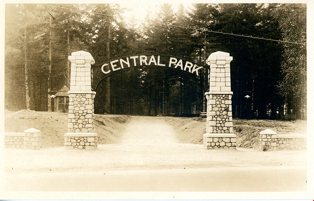
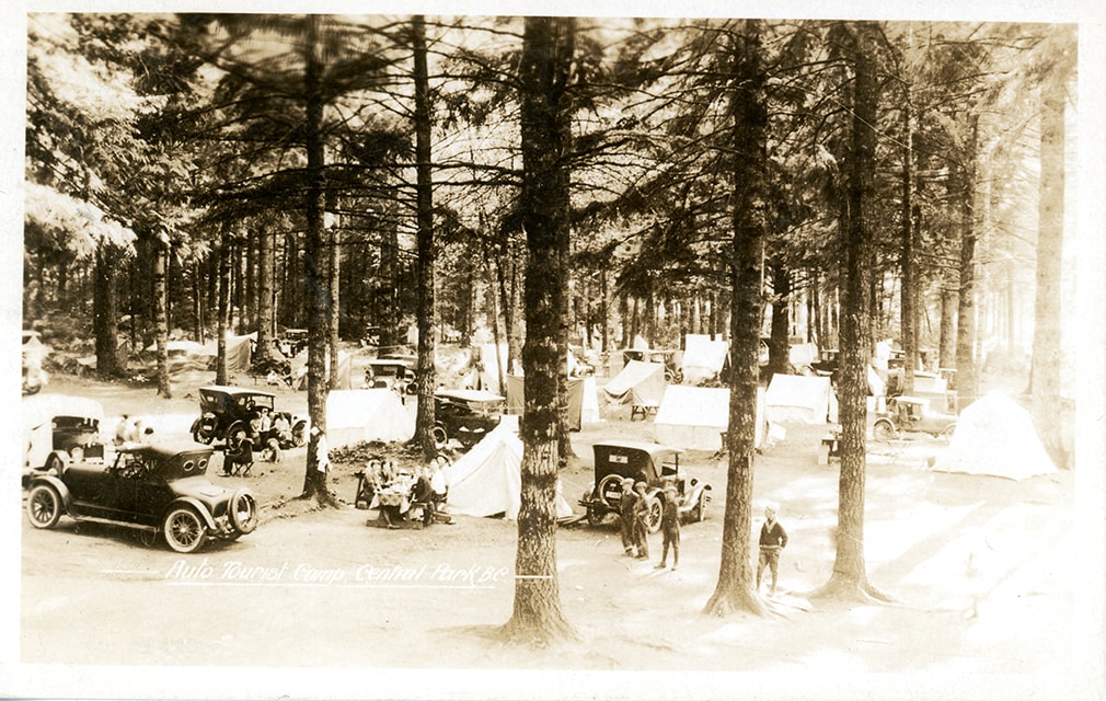
- postcard; Auto Tourist Camp - Postcard -- [1926]. Postcard with a black and white photograph; inscription in white at bottom reads: "Auto Tourist Camp, Central Park B.C." The postcard was published by the Gowen Sutton Company Limited of Vancouver, BC. Verso of postcard includes a postage stamp with King George in the upper right corner and is post marked Sept. 6 and includes a handwritten letter by "Violet" and is addressed to "Roseline Rondeau.../ Oregon".
- Classification
- Written Communication T&E - - Writing Media
- Object Term
- Postcard
- Colour
- Brown
- Black
- White
- Measurements
- w: 14 cm h: 9 cm
- Country Made
- Canada
- Province Made
- British Columbia
- Site/City Made
- Vancouver
- Subjects
- Documentary Artifacts
- Documentary Artifacts - Postcards
- Geographic Features
- Geographic Features - Parks
- Recreational Activities
- Recreational Activities - Camping
- Names
- Central Park Auto Camp
- Historic Neighbourhood
- Central Park (Historic Neighbourhood)
Images
postcard
https://search.heritageburnaby.ca/link/museumartifact90986
- Repository
- Burnaby Village Museum
- Accession Code
- BV021.12.1
- Description
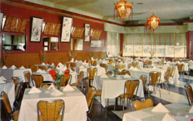
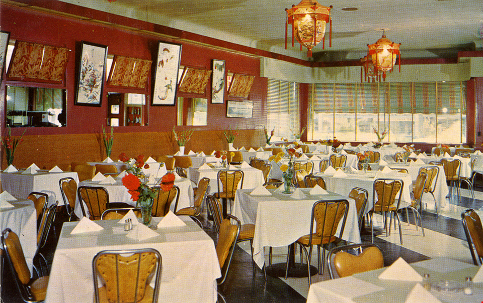
- Postcard: horizontal glossy colour postcard of Golden Dragon Resturant. Shows image of interior dining room with red and gold walls, laterns, tables with white table cloths. yellow chairs and a stripped black and white floor. On reservse in blue print: , "GOLDEN DRAGON" "3991 KINGSWAY" "BURNABY, B.C." "Phone: DExter 5100" "If you are not familiar with Chinese Foods let our Experts make suggestions and explain the traditions of eating that is famous throughout the world."; at bottom, "DINE and DANCE Every FRIDAY & SATURDAY"; line down centre; at right,"POST CARD" "ADDRESS"; at upper right, "STAMP"; unused; ca.1950s
- Object History
- Postcard from the Golden Dragon Resturant which served Chinese-Canadian food. Their grand opening was September 2, 1950. The community staple was known for its neon dragon sign that advertised “Chop Suey”. One side of the kitchen served Chinese foods, while another served Canadian dishes. Chinese cuisine such as rice would be served with chopsticks, while steaks, a more western dish, would be served with knife and fork. Advertisements from the resturant and meeting notices were found in local newspapers from 1950 to 1957. The establishment was not listed in the 1966 Great Vancouver Cross-Cross Directory.
- Classification
- Written Communication T&E - - Writing Media
- Object Term
- Postcard
- Marks/Labels
- Made in Canada by Grant-Mann Lithographers LTD. "Color Card" Division, Vancouver, British Columbia.
- Measurements
- 14cm wide x 9cm high
- Subjects
- Souvenirs
- Persons - Chinese Canadians
- Food Service Tools and Equipment
- Documentary Artifacts - Postcards
- Buildings - Commercial - Restaurants
- Historic Neighbourhood
- Central Park (Historic Neighbourhood)
- Planning Study Area
- Garden Village Area
Images
pram
https://search.heritageburnaby.ca/link/museumartifact91514
- Repository
- Burnaby Village Museum
- Accession Code
- BV021.30.1
- Description
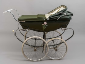
- Green classic Wilson brand pram. There are four narrow wheels, a low-set handle bar and a moveable top canopy and cover with a patterned interior trim. The interior of the pram is white, as is the handlebar, brake handle and wheel covers. On the front end, there is a logo with the brand "Wilson" written in silver cursive, a narrow British flag and a blue tag indicating "Made in England". On either side of the pram, there is a painted pink rose. The knobs on either side of the canopy are also made to look like silver roses, with a yellow and green "W" symbol in their centre.
- Object History
- This pram belonged to George and Elaine (nee Blackstock) Burnett who lived in Burnaby on Elgin Avenue. The couple had four children, but the exact timeline of when this pram was used in unknown. The pram was made in England by the company Silver Cross, which was founded by William Wilson in 1877. It is the founder's surname from which the pram derives its name, which is found on the end of the carriage. George Burnett was employed as the foreman plumber at Oakalla Prison in Burnaby for 30 years. He was also the President of the Royal Canadian Legion Branch 83 in Burnaby. Elaine's family farmed on land in the Deer Lake Area. George and Elaine had four children: John, Derek, Louise, and Lori.
- Reference
- Pioneer Tales of Burnaby, the Corporation of the District of Burnaby: Part III: 1911-1920. Elsie Dawkins Norman. Burnaby Village Museum, Digital Reference Collection. Published 1987. (page 333)
- Classification
- Land Transportation T&E - - Human-Powered Vehicles
- Object Term
- Stroller
- Marks/Labels
- Painted pink roses; Wilson label; Made in England
- Colour
- Green
- Measurements
- height: 100 cm width: 55 cm depth: 124 cm
- Country Made
- England
- Subjects
- Transportation
- Historic Neighbourhood
- Central Park (Historic Neighbourhood)
- Planning Study Area
- Windsor Area
Images

product package; cigar box
https://search.heritageburnaby.ca/link/museumartifact20892
- Repository
- Burnaby Village Museum
- Accession Code
- HV976.14.43
- Description
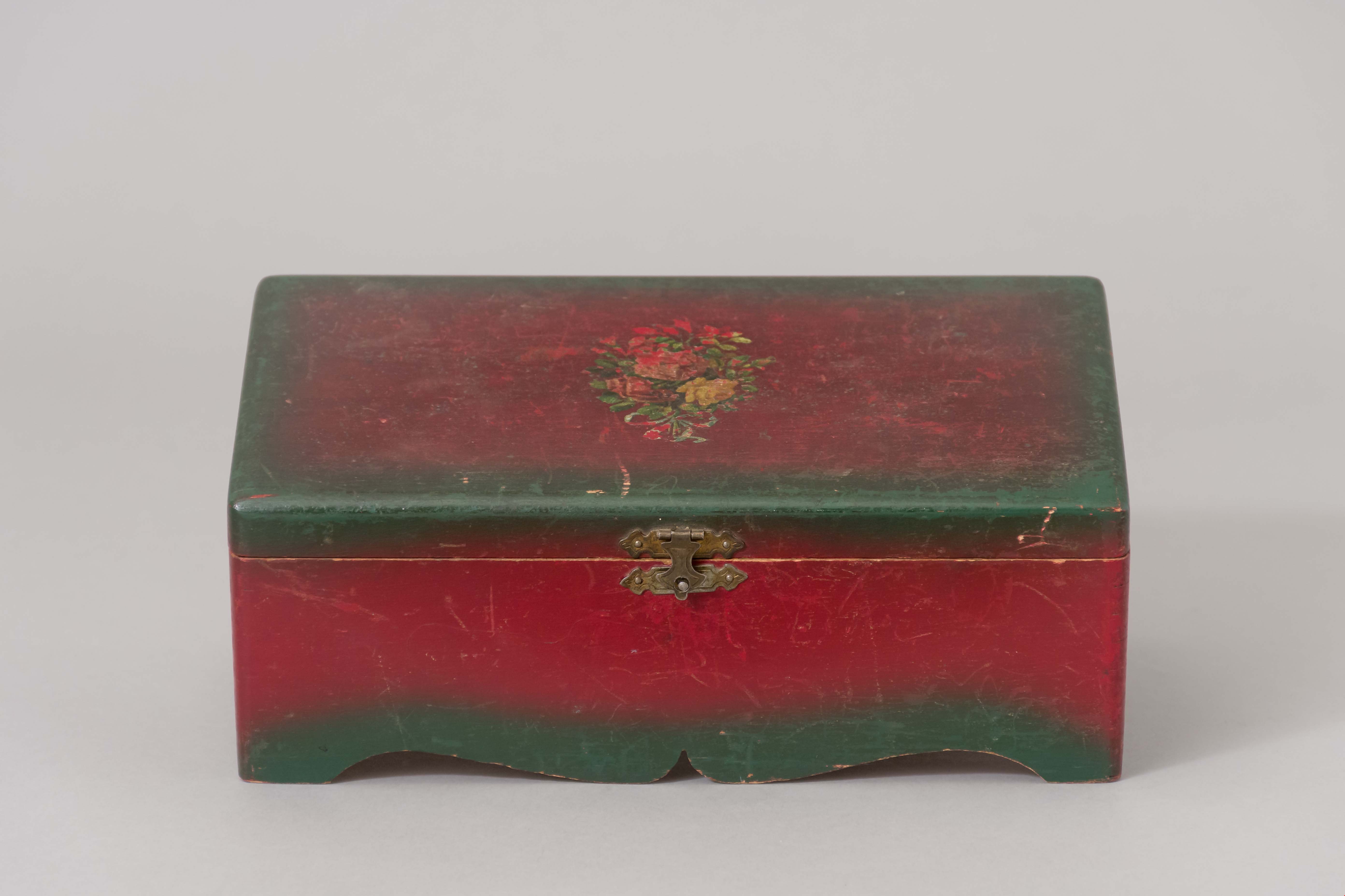
- Box, cigar
- Object History
- This cigar box came from a family who settled in Burnaby in the 1920s,on 3512 Chaffey Avenue in Burnaby. In the 1921 census, William is listed as a poultry rancher. Their children attended Inman Avenue School in Burnaby.
- Category
- 04.Tools & Equipment for Materials
- Classification
- Household Accessories - - Containers for Smoking & Tobacco
- Object Term
- Box, Cigar
- Subjects
- Personal Gear
- Historic Neighbourhood
- Central Park (Historic Neighbourhood)
- Planning Study Area
- Maywood Area
Images
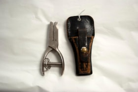
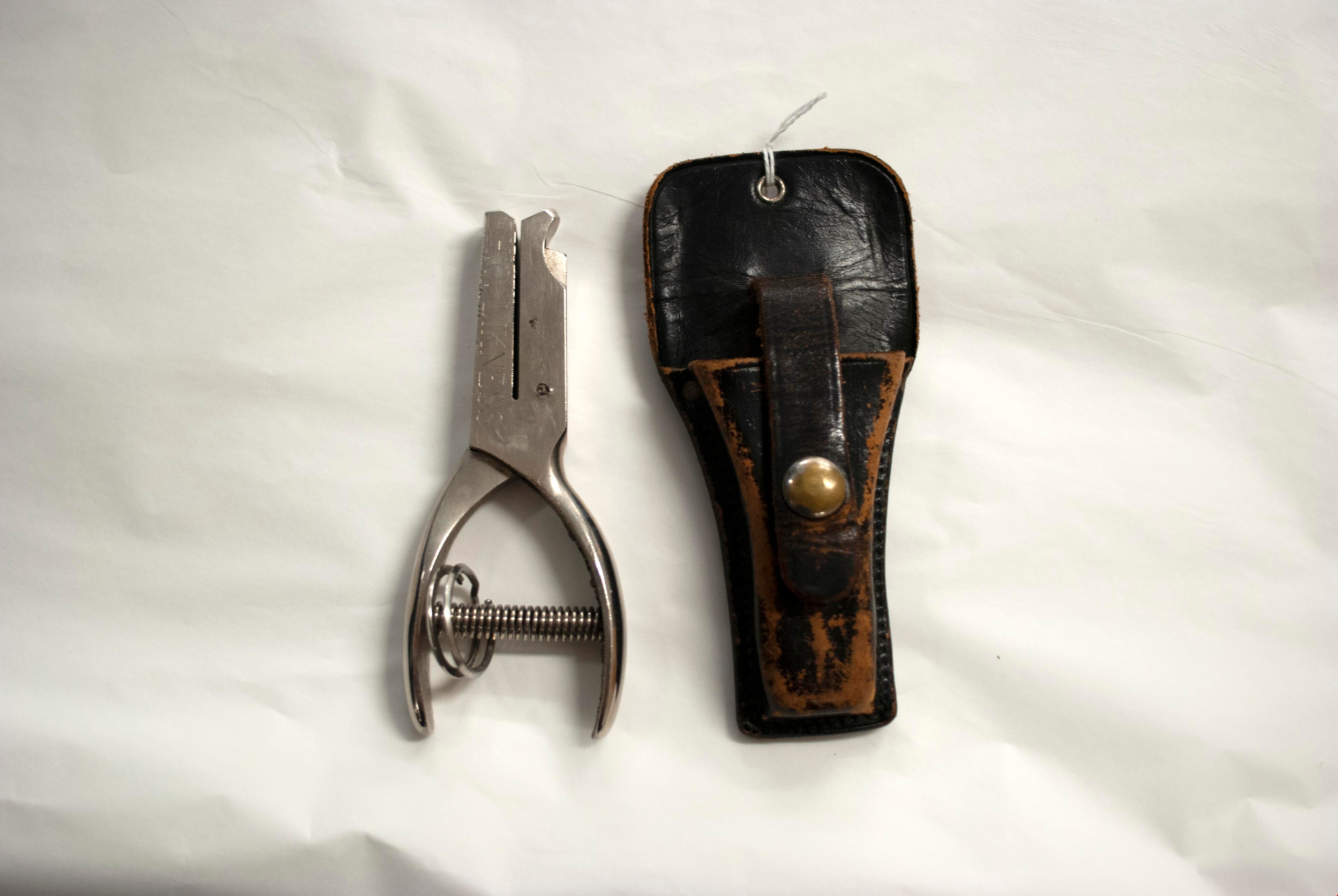
Punch
https://search.heritageburnaby.ca/link/museumartifact90538
- Repository
- Burnaby Village Museum
- Accession Code
- BV020.25.1
- Description
- This is a hand-held metal punch with a spring between the handles. The name "H. Likeness" is engraved into both sides of the punch. It has an accompanying leather holster with a brass snap.
- Object History
- This transfer punch belonged to Harold Likeness. Harold's parents lived in Burnaby, and Harold also lived in Burnaby throughout his life. He drove a bus in Burnaby from about 1955 until 1988. Harold worked at Kensington Depot when it opened in Burnaby in the 1970s. He drove buses around Burnaby, and a regular route he has was up to SFU.He was later moved to the Kitchener bus depot and retired from that location. The punch was from his time as a bus driver.
- Classification
- Land Transportation T&E - - Motor Vehicles
- Land Transportation T&E - - Land Transportation Accessories
- Object Term
- Punch
- Marks/Labels
- H.LIKENESS
- Colour
- Silver
- Brown
- Historic Neighbourhood
- Central Park (Historic Neighbourhood)
- Planning Study Area
- Parkcrest-Aubrey Area
Images
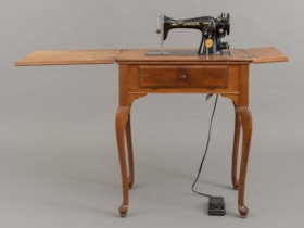
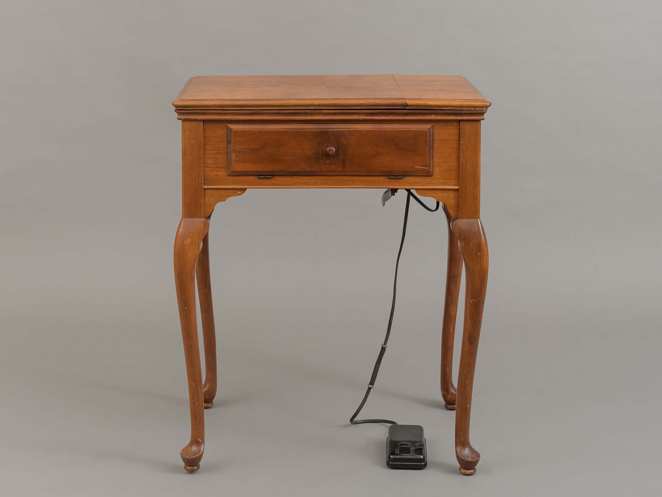
sewing machine
https://search.heritageburnaby.ca/link/museumartifact91513
- Repository
- Burnaby Village Museum
- Accession Code
- BV021.8.1
- Description
- Wooden sewing table and machine. Top of table opens up to reveal a sewing machine, and expands to more work space. Front drawer flips open for more storage space. There is a black pedal attached to machine with a cord. Legs are curved, wood is polished and a warm brown colour.
- Object History
- This sewing machine and set was owned by Rose Tuff . The sewing machine represents a large part of Rose's life, who often sewed her siblings' clothing from a young age while growing up, and left school after Grade 8 to begin working as a dressmaker to help financially support her family. Rose moved to BC in 1941, met her husband Joseph, and the couple moved to South Burnaby. Later in life, Rose continued to pursue the creative arts in many ways including welding, sculpting and teaching creative arts to children aged 6-14 for the Burnaby School Board for eight years.
- Category
- 04.Tools & Equipment for Materials
- Classification
- Textileworking T&E - - Needleworking Equipment
- Object Term
- Sewing Machine
- Colour
- Brown
- Subjects
- Furniture
- Historic Neighbourhood
- Central Park (Historic Neighbourhood)
- Planning Study Area
- Maywood Area
Images

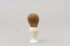
Shaving brush
https://search.heritageburnaby.ca/link/museumartifact212
- Repository
- Burnaby Village Museum
- Accession Code
- HV971.5.50
- Description
- Handheld shaving brush with a white plastic base and tan bristles. Used for mixing and applying shaving cream.
- Object History
- This item belonged to George Jeffery served as a Constable on the Burnaby Police Force from 1912 - 1935. His patrolled the large Central Park District on foot, stretching from Boundary to Royal Oak and Marine Drive to Moscrop. Over the coarse of his duties, Constable Jeffery saw the need for recreational activities in the area. He founded the Burnaby Athletic Association which featured a competitive boxing ring and gym. In 1935, when the Burnaby Police became the British Columbia Provincial Police, rather than leave the community he chose to leave the force. George Jeffery then worked at the nearby Oakalla Prison Farm until retiring in 1945.
- Category
- 03. Personal Artifacts
- Classification
- Personal Gear - - Personal Assistive Artifacts
- Object Term
- Brush
- Marks/Labels
- On the base of the brush "STERILIZED ADGER" "MADE IN" "CANADA" "PEERLESS" "PURE".
- Subjects
- Toilet Articles
- Historic Neighbourhood
- Central Park (Historic Neighbourhood)
- Planning Study Area
- Oakalla Area
Images


Survey and Subdivision plans in New Westminster District Group 1 – Burnaby
https://search.heritageburnaby.ca/link/museumdescription6971
- Repository
- Burnaby Village Museum
- Date
- 1904-1908
- Collection/Fonds
- Burnaby Village Museum Map collection
- Description Level
- File
- Physical Description
- 7 plans : blueprint ink on paper mounted on 2 sides of cardboard 76 cm x 101.5 cm
- Scope and Content
- Item consists of a large board of four New Westminster District Gp 1 -subdivision plans mounted on one side and three New Westminster District Gp 1 - subdivision plans mounted on the other side. Side A: 1. Blueprint "Plan / of Subdivision of / Lot 28A / in Subdivision of / Lot 97, Group 1 / Ne…
- Repository
- Burnaby Village Museum
- Collection/Fonds
- Burnaby Village Museum Map collection
- Description Level
- File
- Physical Description
- 7 plans : blueprint ink on paper mounted on 2 sides of cardboard 76 cm x 101.5 cm
- Material Details
- Scales [between1:120 and 1:3960]
- Index number on edge of board reads: "3"
- Scope and Content
- Item consists of a large board of four New Westminster District Gp 1 -subdivision plans mounted on one side and three New Westminster District Gp 1 - subdivision plans mounted on the other side. Side A: 1. Blueprint "Plan / of Subdivision of / Lot 28A / in Subdivision of / Lot 97, Group 1 / New Westminster District". The B.C.E.R. is identified running through the subdivision of XXVIIIA (Lot 28A). Plan is dated "Sept. 21st, 08" (Geographic location: Burnaby) 2. Blueprint "Measurements / of Discharge / in Ditches / Lots 155A, G.One" / "Scale, Twentieths. / 17/12/04" (Geographic location: Burnaby) 3. Blueprint "Plan / of Subdivision / of a portion of / Lot 95 / Group One / New Westminster District" B.C. Electric Railway runs through the top of the plan. The plan is dated May 23, 1906. (Geographic location: Burnaby) 4. Blueprint " Profile / on Water Surface / in / Holland Road Ditch / Woollard's Ditch / Dec. 3rd 1904 / Scales Hor. 200'=1" / Vert. 10'=1"" (Geographic location: Burnaby) Side B: 1. Blueprint " "Sunnyside Park" / plan of Subdivision / of / the East Half / of / Lot 39, GR.One, / New Westminster District / Scale 100'=1" (Geographic location: Burnaby) 2. Blueprint " "Sunnyside Park"/ plan of Subdivi..n / of / Lot 39, Gr.1. / New Westminster District" Index in upper left corner of plan shows location of Lot 39 in relation to Central Park and surrounding Lots. (Geographic location: Burnaby) 3. Blueprint "Plan / of Subdivision / of / Lot 163 and 165 / Group One / New Westminster District / Scale 5 chs=1 in." Streets within subdivision plan are identified as; North Arm Road, Ingram Street, Blair Street, Kennedy Street, Murray Street, Wiggins Road, Byrne Road, South Road along with North Arm Fraser River and B.C. Electric Railway. (Geographic location: Burnaby)
- Geographic Access
- Central Park
- Accession Code
- HV977.93.3
- Access Restriction
- No restrictions
- Reproduction Restriction
- No known restrictions
- Date
- 1904-1908
- Media Type
- Cartographic Material
- Historic Neighbourhood
- Central Park (Historic Neighbourhood)
- Scan Resolution
- 300
- Scale
- 72
- Notes
- Title based on contents of file
- Scale is measured in chains and feet. (One chain equals 792 inches)
- The term "Lot" can also refer to a "District Lot”
Images


![Survey and Subdivision plans in New Westminster District Group 1 – Burnaby, [1905-1917] thumbnail](/media/hpo/_Data/_BVM_Cartographic_Material/1977/1977_0093_0022a_001.jpg?width=280)
Survey and Subdivision plans in New Westminster District Group 1 – Burnaby
https://search.heritageburnaby.ca/link/museumdescription6991
- Repository
- Burnaby Village Museum
- Date
- [1905-1917]
- Collection/Fonds
- Burnaby Village Museum Map collection
- Description Level
- File
- Physical Description
- 12 plans : 6 black ink on paper + 2 black & col. ink on paper + 4 graphite on paper
- Scope and Content
- Item consists of a large board of six New Westminster District subdivision plans mounted on one side and six New Westminster District subdivision plans mounted on the other side. Side A: 1. Plan drawn in graphite with markings in black ink "Surveyed for Mr. W. Wilson / Paterson Stat. B.C.E.R." . …
- Repository
- Burnaby Village Museum
- Collection/Fonds
- Burnaby Village Museum Map collection
- Description Level
- File
- Physical Description
- 12 plans : 6 black ink on paper + 2 black & col. ink on paper + 4 graphite on paper
- Material Details
- Scales [between 1:360 and 1:3168]
- Index number on edge of board reads: "22"
- Scope and Content
- Item consists of a large board of six New Westminster District subdivision plans mounted on one side and six New Westminster District subdivision plans mounted on the other side. Side A: 1. Plan drawn in graphite with markings in black ink "Surveyed for Mr. W. Wilson / Paterson Stat. B.C.E.R." . Plan includes subdivision of lots situated between B.C.E. Railway and Vancouver Road (Kingsway). (Geographic location: Burnaby) 2. Subdivision plan (no title) drawn in black ink with annotations in graphite. Plan covers District Lots 2, 4 and 6, west of North Road. Plan is stamped: "Albert J. Hill, Civil Engineer / and / Provincial Land Surveyor, / New Westminster, / B.C. (Geographic location: Burnaby) 3. Plan of "Portion of Municipality" with intials "RB" [sic] (handwritten in blue crayon). Plan covers the area north east of the City of New Westminster including District Lots 11, 13, 14, 12, 1 and 2. Plan is stamped: "Albert J. Hill, Civil Engineer / and / Provincial Land Surveyor, / New Westminster, / B.C. (Geographic location: Burnaby) 4."Plan / of Subdivision of / N.W.1/4 Lot 175 / Group 1 New West. Dist. / B.C. / Scale 4 chs = 1 in. " Plan is stamped: "Albert J. Hill, Civil Engineer / and / Provincial Land Surveyor, / New Westminster, / B.C. and initialed : "RB" [sic] (in blue pencil crayon) (Geographic location: Burnaby) 5. "Subdivision / of a Portion of / Lot 15 Group 1 / New Westminster Dist. / Scale 4 chs = 1 in". Plan provides numbered sudivisions - Lots 1 to 15 of District Lot 15 in red ink. (Geographic location: Burnaby) 6. Plan of "Central Park & / Vicinity" Plan includes subdivisions of District Lot 153 east of Central Park District Lot 151 and subdivision of District Lot 36 and 49 west of Boundary Road (Vancouver). Plan is stamped: "Albert J. Hill, Civil Engineer / and / Provincial Land Surveyor, / New Westminster, / B.C. and initialed : "RB" [sic] (in blue pencil crayon). (Geographic location: Burnaby) Side B: 1. Subdivision plan (no title) drawn in black ink. Plan identifies lots between Vancouver Road (Yale Road is crossed out and replaced with Vancouver Road) and B.C.E. Railway. "Scale 2 chs = 1 in" (Geographic location: Burnaby) 2. Plan of "Subdivision Lot 1 / Lot 69 Gr. 1 / Scale 30' = 1 " " Plan identifies Boundary Road, Still Creek and a Road Allowance between District Lot 118 and District Lot 69. Plan was "Surveyed for Burnaby Mun. Council / March 11th 1908 / G.K.B." (Geographic location: Burnaby) 3. Plan drawn in black ink (no title) showing a subdivision in Lot 25 with names "Newcomb", "Debeck" and "Armstrong" along with roads identified as Third Street, Cumberland Street, Armstrong Street and Cariboo [sic] Street and including Lots 27, 11 and 13.Plan is stamped: "Albert J. Hill, Civil Engineer / and / Provincial Land Surveyor, / New Westminster, / B.C. and initialed : "RB" [sic] (in blue pencil crayon). (Geographic location: Burnaby) 4. Handrawn subdivision plan in graphite titled: "Lot 13, Gr.1" with intials "RB" [sic] (handwritten in blue crayon). Plan is bordered by Armstrong Street (Lot 11, G.1), Cumberland St. (Lot 25, G.1) and Tenth Avenue (City Boundary). The plan is singed by "Albert J. Hill / P.L.S." and one of the subdivided lots is identified with the name: "W. Karrymann". (Geographic location: Burnaby) 5. Handrawn sketch in graphite titled: "Lot 88, Gr.1" with intials "RB" [sic] (handwritten in blue crayon). Plan appears to be a draft of a subdivision plan of a portion of District Lot 88 along Cumberland Road. The plan is signed: "16/7/17 _W.F. Draper [sic] / B.C.L.S." (Geographic location: Burnaby) 6. "Plan / of Subdivision / of Blocks 61, 62 and 2 / Lot 30 / Group 1 / N.W. Dist. / Scale 1ch = 1 in". Plan is intialed by: "PB" with a note: "Also see board 2 / for duplicate" (handwritten in blue crayon). (Geographic location: Burnaby)
- Creator
- Hill, Albert James
- Geographic Access
- Boundary Road
- Kingsway
- Cumberland Street
- Accession Code
- HV977.93.22
- Access Restriction
- No restrictions
- Reproduction Restriction
- No known restrictions
- Date
- [1905-1917]
- Media Type
- Cartographic Material
- Historic Neighbourhood
- Central Park (Historic Neighbourhood)
- Scan Resolution
- 300
- Scale
- 100
- Notes
- Title based on contents of file
- Scale is measured in chains and feet. (One chain equals 792 inches)
- The term "Lot" can also refer to a "District Lot”
- Some plans are stamped: "Albert J. Hill, Civil Engineer / and / Provincial Land Surveyor, / New Westminster, / B.C." and intialed: "RB" [sic]
Images
![Survey and Subdivision plans in New Westminster District Group 1 – Burnaby, [1905-1917] thumbnail](/media/hpo/_Data/_BVM_Cartographic_Material/1977/1977_0093_0022a_001.jpg)

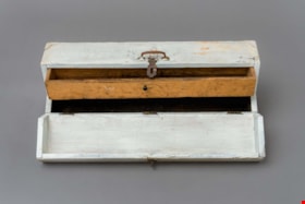
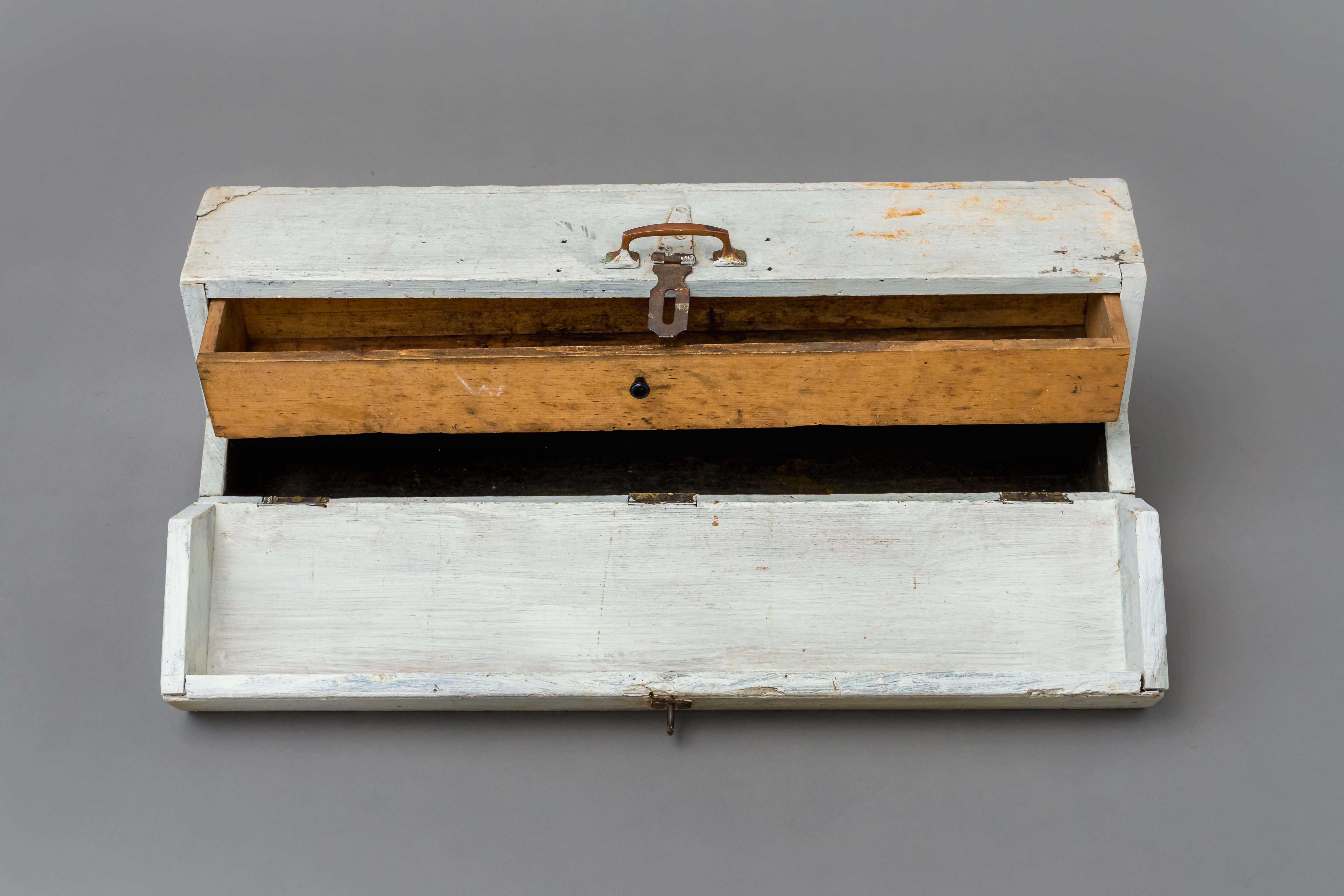
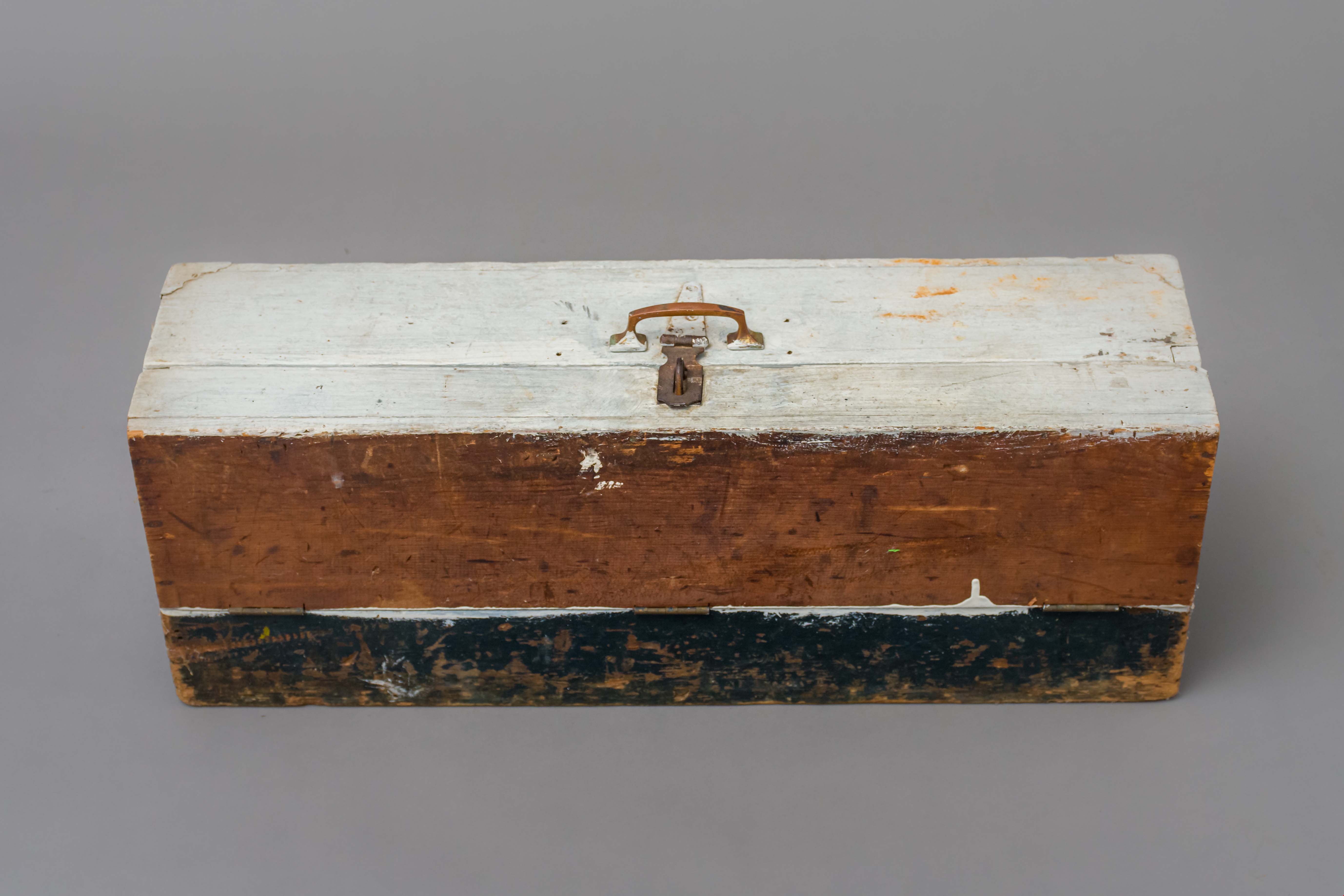
Toolbox
https://search.heritageburnaby.ca/link/museumartifact89169
- Repository
- Burnaby Village Museum
- Accession Code
- BV018.23.2
- Description
- toolbox; hand-made toolbox with pull-out interior drawer; wood with 3/4 fold-down lid, metal carry handle and lock hasp; steel hinges and two metal corners at top of box; white and black paint; unpainted wood interior drawer with small pull handle.
- Object History
- This tool box was made by donor's father David, who worked as a machinest at Heaps Engineering in New Westminster. David was born in Scotland in 1882 and immigrated to Canada. He lived in Spruce Street and Telford Street in Burnaby. His children atteneded Kingsway West Elementary School, South Burnaby and King Edward High School.
- Category
- 04.Tools & Equipment for Materials
- Classification
- Multiple Use T&E for Materials
- Object Term
- Container, Tool
- Measurements
- L: 71.2 cm W: 20.0 H: 25.0 cm
- Historic Neighbourhood
- Central Park (Historic Neighbourhood)
- Planning Study Area
- Maywood Area
Images
Trophy
https://search.heritageburnaby.ca/link/museumartifact90819
- Repository
- Burnaby Village Museum
- Accession Code
- BV020.40.10
- Description
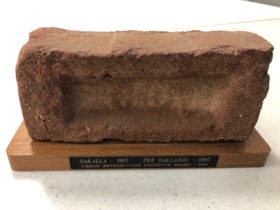
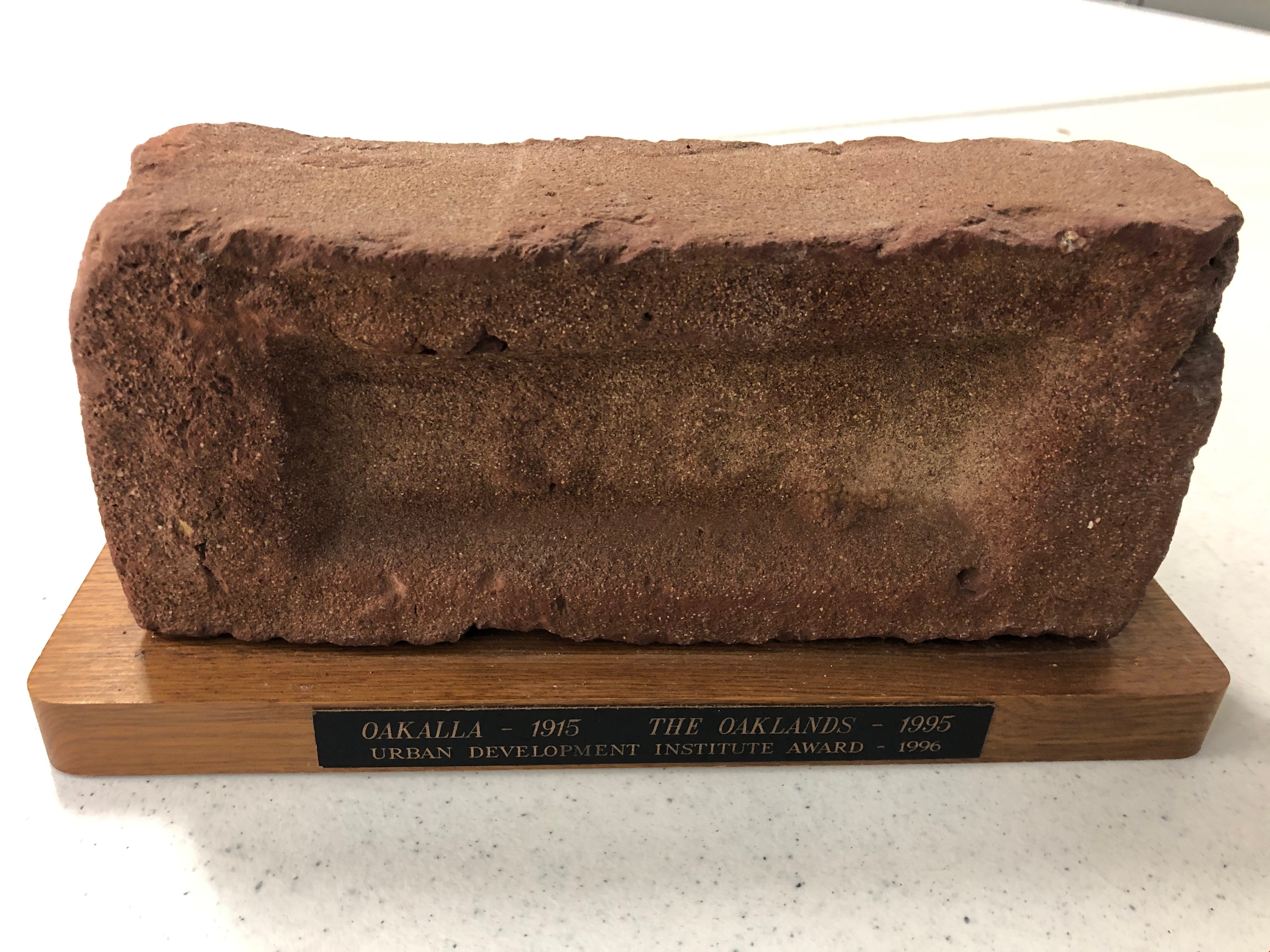
- Maroon brick mounted to a brown varnished wooden stand. On one long edge of the wooden stand is a black plaque with gold letteres reads: OAKALLA 1915 / THE OAKLANDS / Urban Development Institute Award - 1996
- Object History
- This was awarded to the City of Burnaby Planning Department by the Urban Development Institute in 1996 for the redevlopment of the lands which were Oakalla Provincial Prison from 1915-1991.
- Category
- 08. Communication Artifacts
- Classification
- Personal Symbols - - Achievement Symbols
- Object Term
- Trophy
- Colour
- Maroon
- Brown
- Subjects
- Building Components
- Ceremonies - Awards
- Planning - City Planning
- Public Services - Correctional
- Names
- Oakalla Prison Farm
- Historic Neighbourhood
- Central Park (Historic Neighbourhood)
- Planning Study Area
- Oakalla Area
Images
violet ray generator kit
https://search.heritageburnaby.ca/link/museumartifact5622
- Repository
- Burnaby Village Museum
- Accession Code
- BV986.20.2
- Description
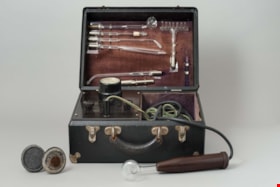
- Violet ray generator; box is black, silver corners, hinged lid, two hinged snap closures, black handle; inside lid is brown velvet with silver holders for glass tube attachments; plaque "CHAS.A.BRANSTON LIMITED"; in box left side is voltage dial, three black control knobs; right side is compartment for two cords, one with plug end, other with hollow brown bakelite? handle; with two discs on handles, two metal tubes, one roller with handle, metal rectangle, and red instruction booklet "THE BRANSTON VIOLET RAY HIGH FREQUENCY GENERATOR", illustrated; c. 1928
- Object History
- This is a Branston Violet Ray Generator. Branston’s claims were similar to those of other Violet Ray makers. Treatments are given for over a hundred ailments, ranging from abscess through appendicitis, colitis, diabetes, glaucoma, gonorrhoea, haemmorrhoids, impotence, laryngitis, mumps, pyorrhea, tuberculosis, ulcers, wrinkles and even writer’s cramp. Electrical medical devices like this one were popular for decades among physicians, irregular practitioners, and home users, who could purchase them through catalogs and drugstores. The machine plugs into an electrical wall outlet. A glass electrode plugs into the wand, produces a violet glow, and delivers a spark when touched to the skin. The strength of the spark, controlled by the voltage selector, ranges from mild to quite intense. Attachments could stimulate many body parts.
- Classification
- Energy Production T&E - - Other Energy Production T&E
- Object Term
- Generator
- Historic Neighbourhood
- Central Park (Historic Neighbourhood)
- Planning Study Area
- Douglas-Gilpin Area
Images
