Narrow Results By
Subject
- Buildings - Religious - Churches 14
- Buildings - Residential - Houses 1
- Construction 1
- Construction Tools and Equipment 1
- Geographic Features - Rivers 1
- Geographic Features - Roads 1
- Geographic Features - Sidewalks 1
- Land Clearing 1
- Maunfactured Products - Logs 1
- Occupations - Clergy 2
- Transportation - Horses 1
- Transportation - Trucks 1
Person / Organization
- Grayson, Reverend Donald 1
- Luterback, Father Dennis 1
- McGeachie, John Aloysius "Jack" 1
- Minni, Sheila 1
- Morrison, Reverend George 1
- Our Lady of Mercy Church 6
- Priest, Bobby 1
- Sims, Jack 2
- St. Helen's Catholic Church 5
- St. Michael's Centre Extended Care and Hospice Facility 1
- St. Theresa's Roman Catholic Church 5

Construction of Saint Theresa's Roman Catholic Church
https://search.heritageburnaby.ca/link/museumdescription903
- Repository
- Burnaby Village Museum
- Date
- March 19, 1929
- Collection/Fonds
- Burnaby Village Museum Photograph collection
- Description Level
- Item
- Physical Description
- 1 photograph : sepia ; 6.9 x 11.5 cm
- Scope and Content
- Photograph of Douglas Road (later renamed in part Canada Way) with Laurel Street in the background on the left and the site of Saint Theresa's Roman Catholic Church as a lot with blackened stumps. The church was located at the southeast corner of Canada Way and Laurel Street. The photograph is ta…
- Repository
- Burnaby Village Museum
- Collection/Fonds
- Burnaby Village Museum Photograph collection
- Description Level
- Item
- Physical Description
- 1 photograph : sepia ; 6.9 x 11.5 cm
- Scope and Content
- Photograph of Douglas Road (later renamed in part Canada Way) with Laurel Street in the background on the left and the site of Saint Theresa's Roman Catholic Church as a lot with blackened stumps. The church was located at the southeast corner of Canada Way and Laurel Street. The photograph is taken from the same angle as HV975.105.1. There is a freight wagon loaded with lumber, pulled by two horses on Douglas Road. An annotation on the back of the photo reads, "March 19th 1929 / The first load of lumber taken for the construction of St St [sic] Therese [sic] Church on the Grandview Highway / Burnaby BC."
- Geographic Access
- Douglas Road
- Canada Way
- Laurel Street
- Accession Code
- HV975.105.2
- Access Restriction
- No restrictions
- Reproduction Restriction
- No known restrictions
- Date
- March 19, 1929
- Media Type
- Photograph
- Historic Neighbourhood
- Burnaby Lake (Historic Neighbourhood)
- Planning Study Area
- Douglas-Gilpin Area
- Scan Resolution
- 600
- Scan Date
- 2023-06-13
- Notes
- Title based on contents of photograph
- Information on the scope and content of the photograph is taken from an acquisition record from the time of the accession
Images

![Eight Clergymen at Saint Theresa's Roman Catholic Church, [192-] thumbnail](/media/hpo/_Data/_BVM_Images/1975/1975_0105_0003_001.jpg?width=280)
Eight Clergymen at Saint Theresa's Roman Catholic Church
https://search.heritageburnaby.ca/link/museumdescription904
- Repository
- Burnaby Village Museum
- Date
- [192-]
- Collection/Fonds
- Burnaby Village Museum Photograph collection
- Description Level
- Item
- Physical Description
- 1 photograph : b&w ; 5.7 x 8.2 cm
- Scope and Content
- Photograph of eight unidentified clergymen posed outside in front of a brick building. Four are standing and the other four are seated in front of the standing men. On the right side of the photo, there is a sign that reads, "In Your Prayers / Kindly Remember." The location has been identified as…
- Repository
- Burnaby Village Museum
- Collection/Fonds
- Burnaby Village Museum Photograph collection
- Description Level
- Item
- Physical Description
- 1 photograph : b&w ; 5.7 x 8.2 cm
- Scope and Content
- Photograph of eight unidentified clergymen posed outside in front of a brick building. Four are standing and the other four are seated in front of the standing men. On the right side of the photo, there is a sign that reads, "In Your Prayers / Kindly Remember." The location has been identified as Saint Theresa's Roman Catholic Church. The church was located at the southeast corner of Canada Way and Laurel Street. Built in 1929, it was torn down in 1974, and a new church, St.Theresa's Parish, was built across the street.
- Subjects
- Occupations - Clergy
- Geographic Access
- Douglas Road
- Canada Way
- Laurel Street
- Accession Code
- HV975.105.3
- Access Restriction
- No restrictions
- Reproduction Restriction
- May be restricted by third party rights
- Date
- [192-]
- Media Type
- Photograph
- Historic Neighbourhood
- Burnaby Lake (Historic Neighbourhood)
- Planning Study Area
- Douglas-Gilpin Area
- Scan Resolution
- 600
- Scan Date
- 2023-06-13
- Notes
- Title based on contents of photograph
Images
![Eight Clergymen at Saint Theresa's Roman Catholic Church, [192-] thumbnail](/media/hpo/_Data/_BVM_Images/1975/1975_0105_0003_001.jpg)

Land being cleared for Saint Theresa's Roman Catholic Church
https://search.heritageburnaby.ca/link/museumdescription902
- Repository
- Burnaby Village Museum
- Date
- 1929
- Collection/Fonds
- Burnaby Village Museum Photograph collection
- Description Level
- Item
- Physical Description
- 1 photograph : b&w ; 6.7 x 11.4 cm
- Scope and Content
- Photograph of three unidentified men standing on Douglas Road (later renamed in part Canada Way) with Laurel Street in the background on the left and the site of Saint Theresa's Roman Catholic Church as a lot with blackened stumps. The church was located at the southeast corner of Canada Way and L…
- Repository
- Burnaby Village Museum
- Collection/Fonds
- Burnaby Village Museum Photograph collection
- Description Level
- Item
- Physical Description
- 1 photograph : b&w ; 6.7 x 11.4 cm
- Scope and Content
- Photograph of three unidentified men standing on Douglas Road (later renamed in part Canada Way) with Laurel Street in the background on the left and the site of Saint Theresa's Roman Catholic Church as a lot with blackened stumps. The church was located at the southeast corner of Canada Way and Laurel Street. According to an accompanying note located with the photograph, the first church building burned to the ground the night before it was to be blessed. Insurance for the church had been arranged for by Colonel Dorrell only hours before it was burned and even though signatures had not been affixed to the policy, the insurance company honoured the claim. The second building was smaller and had no basement. Father Trainer was the first priest. This church was torn down in 1974 and a new church building was erected across the road on Canada Way.
- Subjects
- Land Clearing
- Geographic Access
- Douglas Road
- Canada Way
- Laurel Street
- Accession Code
- HV975.105.1
- Access Restriction
- No restrictions
- Reproduction Restriction
- No known restrictions
- Date
- 1929
- Media Type
- Photograph
- Historic Neighbourhood
- Burnaby Lake (Historic Neighbourhood)
- Planning Study Area
- Douglas-Gilpin Area
- Scan Resolution
- 600
- Scan Date
- 2023-06-06
- Notes
- Title based on contents of photograph
- Information on the scope and content of the photograph is taken from an acquisition record from the time of the accession
Images

![Saint Theresa's Roman Catholic Church, [between 1970 and 1974] thumbnail](/media/Hpo/_Data/_Archives_Images/_Unrestricted/205/237-001.jpg?width=280)
Saint Theresa's Roman Catholic Church
https://search.heritageburnaby.ca/link/archivedescription36218
- Repository
- City of Burnaby Archives
- Date
- [between 1970 and 1974]
- Collection/Fonds
- Burnaby Historical Society fonds
- Description Level
- Item
- Physical Description
- 1 photograph : col. 12.5 x 17 cm
- Scope and Content
- Photograph of Jack Sims and Father Chang standing in front of St. Theresa's Church, shaking hands. The church was located at the southeast corner of Canada Way and Laurel Street. Built in 1929, it was torn down in 1974, and a new church, St.Theresa's Parish, was built across the street.
- Repository
- City of Burnaby Archives
- Date
- [between 1970 and 1974]
- Collection/Fonds
- Burnaby Historical Society fonds
- Subseries
- Pixie McGeachie subseries
- Physical Description
- 1 photograph : col. 12.5 x 17 cm
- Description Level
- Item
- Record No.
- 237-001
- Access Restriction
- No restrictions
- Reproduction Restriction
- Reproduce for fair dealing purposes only
- Accession Number
- BHS1989-28
- Scope and Content
- Photograph of Jack Sims and Father Chang standing in front of St. Theresa's Church, shaking hands. The church was located at the southeast corner of Canada Way and Laurel Street. Built in 1929, it was torn down in 1974, and a new church, St.Theresa's Parish, was built across the street.
- Subjects
- Buildings - Religious - Churches
- Media Type
- Photograph
- Notes
- Title based on contents of photograph
- Geographic Access
- Laurel Street
- Canada Way
- Historic Neighbourhood
- Burnaby Lake (Historic Neighbourhood)
- Planning Study Area
- Douglas-Gilpin Area
Images
![Saint Theresa's Roman Catholic Church, [between 1970 and 1974] thumbnail](/media/Hpo/_Data/_Archives_Images/_Unrestricted/205/237-001.jpg)
![Saint Theresa's Roman Catholic Church, [between 1970 and 1974] thumbnail](/media/Hpo/_Data/_Archives_Images/_Unrestricted/205/237-002.jpg?width=280)
Saint Theresa's Roman Catholic Church
https://search.heritageburnaby.ca/link/archivedescription36219
- Repository
- City of Burnaby Archives
- Date
- [between 1970 and 1974]
- Collection/Fonds
- Burnaby Historical Society fonds
- Description Level
- Item
- Physical Description
- 1 photograph : col. ; 17 x 12.5 cm
- Scope and Content
- Photograph of Jack Sims and John Aloysius "Jack" McGeachie sitting on the front steps of St. Theresa's Church. Both men are dressed in white.The church was located at the southeast corner of Canada Way and Laurel Street. Built in 1929, it was torn down in 1974, and a new church, St.Theresa's Parish…
- Repository
- City of Burnaby Archives
- Date
- [between 1970 and 1974]
- Collection/Fonds
- Burnaby Historical Society fonds
- Subseries
- Pixie McGeachie subseries
- Physical Description
- 1 photograph : col. ; 17 x 12.5 cm
- Description Level
- Item
- Record No.
- 237-002
- Access Restriction
- No restrictions
- Reproduction Restriction
- Reproduce for fair dealing purposes only
- Accession Number
- BHS1989-28
- Scope and Content
- Photograph of Jack Sims and John Aloysius "Jack" McGeachie sitting on the front steps of St. Theresa's Church. Both men are dressed in white.The church was located at the southeast corner of Canada Way and Laurel Street. Built in 1929, it was torn down in 1974, and a new church, St.Theresa's Parish, was built across the street.
- Subjects
- Buildings - Religious - Churches
- Media Type
- Photograph
- Notes
- Title based on contents of photograph
- Geographic Access
- Laurel Street
- Canada Way
- Historic Neighbourhood
- Burnaby Lake (Historic Neighbourhood)
- Planning Study Area
- Douglas-Gilpin Area
Images
![Saint Theresa's Roman Catholic Church, [between 1970 and 1974] thumbnail](/media/Hpo/_Data/_Archives_Images/_Unrestricted/205/237-002.jpg)
![St. Helen's Catholic Church, [1912] (date of original), copied 1986 thumbnail](/media/hpo/_Data/_Archives_Images/_Unrestricted/204/204-288.jpg?width=280)
St. Helen's Catholic Church
https://search.heritageburnaby.ca/link/archivedescription35430
- Repository
- City of Burnaby Archives
- Date
- [1912] (date of original), copied 1986
- Collection/Fonds
- Burnaby Historical Society fonds
- Description Level
- Item
- Physical Description
- 1 photograph : b&w ; 12.7 x 17.8 cm print
- Scope and Content
- Photograph of St. Helen's Catholic Church soon after it was built at 3894 Triumph Street. Photo by Dr. Carl Eaton.
- Repository
- City of Burnaby Archives
- Date
- [1912] (date of original), copied 1986
- Collection/Fonds
- Burnaby Historical Society fonds
- Subseries
- Pioneer Tales subseries
- Physical Description
- 1 photograph : b&w ; 12.7 x 17.8 cm print
- Description Level
- Item
- Record No.
- 204-288
- Access Restriction
- No restrictions
- Reproduction Restriction
- No restrictions
- Accession Number
- BHS1988-03
- Scope and Content
- Photograph of St. Helen's Catholic Church soon after it was built at 3894 Triumph Street. Photo by Dr. Carl Eaton.
- Subjects
- Buildings - Religious - Churches
- Media Type
- Photograph
- Photographer
- Eaton, Dr. Carl
- Notes
- Title based on contents of photograph
- Geographic Access
- Triumph Street
- Street Address
- 3894 Triumph Street
- Historic Neighbourhood
- Vancouver Heights (Historic Neighbourhood)
- Planning Study Area
- Burnaby Heights Area
Images
![St. Helen's Catholic Church, [1912] (date of original), copied 1986 thumbnail](/media/hpo/_Data/_Archives_Images/_Unrestricted/204/204-288.jpg)
![Moving St. Helen's Church, [1955-1956] thumbnail](/media/hpo/_Data/_Archives_Images/_Unrestricted/494/495-003.jpg?width=280)
Moving St. Helen's Church
https://search.heritageburnaby.ca/link/archivedescription58379
- Repository
- City of Burnaby Archives
- Date
- [1955-1956]
- Collection/Fonds
- Sheila Minni fonds
- Description Level
- Item
- Physical Description
- 1 photograph : sepia ; 4.5 x 7 cm
- Scope and Content
- Photograph of a truck moving the St. Helen's Church building. The Church was replaced in 1956 with a new building.
- Repository
- City of Burnaby Archives
- Date
- [1955-1956]
- Collection/Fonds
- Sheila Minni fonds
- Physical Description
- 1 photograph : sepia ; 4.5 x 7 cm
- Description Level
- Item
- Record No.
- 495-003
- Access Restriction
- No restrictions
- Reproduction Restriction
- No known restrictions
- Accession Number
- 2009-04
- Scope and Content
- Photograph of a truck moving the St. Helen's Church building. The Church was replaced in 1956 with a new building.
- Media Type
- Photograph
- Notes
- Title based on contents of photograph
- Geographic Access
- Triumph Street
- Street Address
- 3894 Triumph Street
- Historic Neighbourhood
- Vancouver Heights (Historic Neighbourhood)
- Planning Study Area
- Burnaby Heights Area
Images
![Moving St. Helen's Church, [1955-1956] thumbnail](/media/hpo/_Data/_Archives_Images/_Unrestricted/494/495-003.jpg)
![St. Helen's Church, [1930] thumbnail](/media/hpo/_Data/_Archives_Images/_Unrestricted/371/476-014.jpg?width=280)
St. Helen's Church
https://search.heritageburnaby.ca/link/archivedescription38671
- Repository
- City of Burnaby Archives
- Date
- [1930]
- Collection/Fonds
- Burnaby Historical Society fonds
- Description Level
- Item
- Physical Description
- 1 photograph : sepia ; 14.5 x 20.5 cm
- Scope and Content
- Photograph of St. Helen's Church, manse and hall. Two priests can be seen standing on the steps of the manse, both are unidentified.
- Repository
- City of Burnaby Archives
- Date
- [1930]
- Collection/Fonds
- Burnaby Historical Society fonds
- Subseries
- North Burnaby Board of Trade subseries
- Physical Description
- 1 photograph : sepia ; 14.5 x 20.5 cm
- Description Level
- Item
- Record No.
- 476-014
- Access Restriction
- No restrictions
- Reproduction Restriction
- No known restrictions
- Accession Number
- BHS2005-8
- Scope and Content
- Photograph of St. Helen's Church, manse and hall. Two priests can be seen standing on the steps of the manse, both are unidentified.
- Subjects
- Buildings - Religious - Churches
- Media Type
- Photograph
- Notes
- Title based on contents of photograph
- Geographic Access
- Ingleton Avenue
- Triumph Street
- Street Address
- 3894 Triumph Street
- Historic Neighbourhood
- Vancouver Heights (Historic Neighbourhood)
- Planning Study Area
- Burnaby Heights Area
Images
![St. Helen's Church, [1930] thumbnail](/media/hpo/_Data/_Archives_Images/_Unrestricted/371/476-014.jpg)
![St. Helen's Church, [1955-1956] thumbnail](/media/hpo/_Data/_Archives_Images/_Unrestricted/494/495-001.jpg?width=280)
St. Helen's Church
https://search.heritageburnaby.ca/link/archivedescription58377
- Repository
- City of Burnaby Archives
- Date
- [1955-1956]
- Collection/Fonds
- Sheila Minni fonds
- Description Level
- Item
- Physical Description
- 1 photograph : sepia ; 4.5 x 7 cm
- Scope and Content
- Photograph of a fire at the manse next to St. Helen's Church. Two children with bicycles can be seen standing near the street corner.
- Repository
- City of Burnaby Archives
- Date
- [1955-1956]
- Collection/Fonds
- Sheila Minni fonds
- Physical Description
- 1 photograph : sepia ; 4.5 x 7 cm
- Description Level
- Item
- Record No.
- 495-001
- Access Restriction
- No restrictions
- Reproduction Restriction
- No known restrictions
- Accession Number
- 2009-04
- Scope and Content
- Photograph of a fire at the manse next to St. Helen's Church. Two children with bicycles can be seen standing near the street corner.
- Subjects
- Buildings - Religious - Churches
- Media Type
- Photograph
- Notes
- Title based on contents of photograph
- Geographic Access
- Triumph Street
- Street Address
- 3894 Triumph Street
- Historic Neighbourhood
- Vancouver Heights (Historic Neighbourhood)
- Planning Study Area
- Burnaby Heights Area
Images
![St. Helen's Church, [1955-1956] thumbnail](/media/hpo/_Data/_Archives_Images/_Unrestricted/494/495-001.jpg)
![St. Helen's Church Steeple, [1955-1956] thumbnail](/media/hpo/_Data/_Archives_Images/_Unrestricted/494/495-002.jpg?width=280)
St. Helen's Church Steeple
https://search.heritageburnaby.ca/link/archivedescription58378
- Repository
- City of Burnaby Archives
- Date
- [1955-1956]
- Collection/Fonds
- Sheila Minni fonds
- Description Level
- Item
- Physical Description
- 1 photograph : sepia ; 4.5 x 7 cm
- Scope and Content
- Photograph of the steeple of St. Helen's Church after it was torn down. The Church was replaced in 1956 when a new building was constructed. Siting inside the steeple are three children: the girl on the right has been identified as Sheila Minni, the boy seated up in the middle of the steeple is B…
- Repository
- City of Burnaby Archives
- Date
- [1955-1956]
- Collection/Fonds
- Sheila Minni fonds
- Physical Description
- 1 photograph : sepia ; 4.5 x 7 cm
- Description Level
- Item
- Record No.
- 495-002
- Access Restriction
- No restrictions
- Reproduction Restriction
- No known restrictions
- Accession Number
- 2009-04
- Scope and Content
- Photograph of the steeple of St. Helen's Church after it was torn down. The Church was replaced in 1956 when a new building was constructed. Siting inside the steeple are three children: the girl on the right has been identified as Sheila Minni, the boy seated up in the middle of the steeple is Bobby Priest and the other girl is known only as Katherine.
- Subjects
- Buildings - Religious - Churches
- Media Type
- Photograph
- Notes
- Title based on contents of photograph
- Geographic Access
- Triumph Street
- Street Address
- 3894 Triumph Street
- Historic Neighbourhood
- Vancouver Heights (Historic Neighbourhood)
- Planning Study Area
- Burnaby Heights Area
Images
![St. Helen's Church Steeple, [1955-1956] thumbnail](/media/hpo/_Data/_Archives_Images/_Unrestricted/494/495-002.jpg)
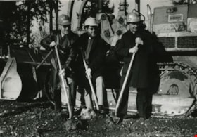
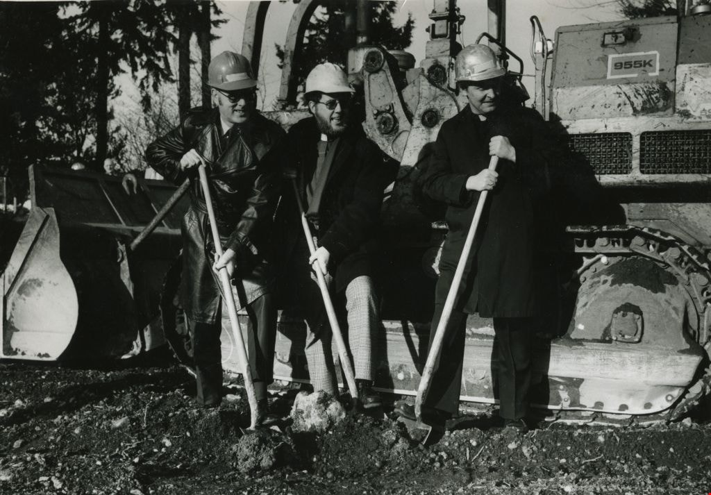
Construction of the St. Michael's Centre
https://search.heritageburnaby.ca/link/archivedescription45354
- Repository
- City of Burnaby Archives
- Date
- January 1980
- Collection/Fonds
- Columbian Newspaper collection
- Description Level
- Item
- Physical Description
- 1 photograph : b&w ; 16.5 x 24 cm
- Scope and Content
- Photograph of Reverend George Morrison of the United Church, Reverend Donald Grayson of the Anglican Church, and Father Dennis Luterback of the Catholic Church with hard hats on and shovels in their hands. They were participating in the sod turning ceremony for the then new combined care facility f…
- Repository
- City of Burnaby Archives
- Date
- January 1980
- Collection/Fonds
- Columbian Newspaper collection
- Physical Description
- 1 photograph : b&w ; 16.5 x 24 cm
- Description Level
- Item
- Record No.
- 480-249
- Access Restriction
- No restrictions
- Reproduction Restriction
- Reproduce for fair dealing purposes only
- Accession Number
- 2003-02
- Scope and Content
- Photograph of Reverend George Morrison of the United Church, Reverend Donald Grayson of the Anglican Church, and Father Dennis Luterback of the Catholic Church with hard hats on and shovels in their hands. They were participating in the sod turning ceremony for the then new combined care facility for seniors being built by St. Michael's Centre Society in South Burnaby.
- Names
- St. Michael's Centre Extended Care and Hospice Facility
- Morrison, Reverend George
- Grayson, Reverend Donald
- Luterback, Father Dennis
- Media Type
- Photograph
- Notes
- Title based on contents of photograph
- Newspaper clipping attached to verso of photograph reads: "DIGGING IN ... Sod turning ceremony for new 80-bed combined care facility for seniors being built by St. Michael's Centre Society was held recently. Participating in ceremony were, from left to right, Rev. George Morrison of United Church, Rev. Donald Grayson of Anglican Church, and Father Dennis Luterback of Catholic Church."
- Geographic Access
- Sussex Avenue
- Street Address
- 7451 Sussex Avenue
- Historic Neighbourhood
- Alta-Vista (Historic Neighbourhood)
- Planning Study Area
- Sussex-Nelson Area
Images
![Looking north across the Fraser River, [1890] thumbnail](/media/hpo/_Data/_Archives_Images/_Unrestricted/477/477-903.jpg?width=280)
Looking north across the Fraser River
https://search.heritageburnaby.ca/link/archivedescription39584
- Repository
- City of Burnaby Archives
- Date
- [1890]
- Collection/Fonds
- Peers Family and Hill Family fonds
- Description Level
- Item
- Physical Description
- 1 photograph : b&w ; 16.5 x 24 cm on page 21.5 x 28 cm (pasted in album)
- Scope and Content
- Photograph of New Westminster, taken from Surrey's Brownsville dock area on the south side of the Fraser River, with the span of the city's downtown and residential area in a panorama from the foot of 8th Street on the left as far east as Elliot Street on the extreme right. The peeled and chamfered…
- Repository
- City of Burnaby Archives
- Date
- [1890]
- Collection/Fonds
- Peers Family and Hill Family fonds
- Physical Description
- 1 photograph : b&w ; 16.5 x 24 cm on page 21.5 x 28 cm (pasted in album)
- Description Level
- Item
- Record No.
- 477-903
- Access Restriction
- No restrictions
- Reproduction Restriction
- No known restrictions
- Accession Number
- 2007-12
- Scope and Content
- Photograph of New Westminster, taken from Surrey's Brownsville dock area on the south side of the Fraser River, with the span of the city's downtown and residential area in a panorama from the foot of 8th Street on the left as far east as Elliot Street on the extreme right. The peeled and chamfered logs on the riverbank were transported by skid road and river and are typical of how Burnaby logs would have been stored prior to milling by the sawmill companies located in the city. The large white church building on the right is St. Peters Catholic Church built in 1886 at Blackwood and Columbia streets. Note that the large building at the center on the waterfront is the New Westminster City Market building (It has the central gable and arched opening). It was located on Front Street at Lytton Square and served as the primary place for Burnaby's market gardeners to sell their produce. To the right of the City Market is the city's original Chinatown located on the east end of Front Street.
- Media Type
- Photograph
- Notes
- Title based on caption accompanying photograph
Images
![Looking north across the Fraser River, [1890] thumbnail](/media/hpo/_Data/_Archives_Images/_Unrestricted/477/477-903.jpg)

Our Lady of Mercy Church Manse
https://search.heritageburnaby.ca/link/archivedescription35074
- Repository
- City of Burnaby Archives
- Date
- October 21, 1986
- Collection/Fonds
- Burnaby Historical Society fonds
- Description Level
- Item
- Physical Description
- 1 photograph : b&w ; 8.8 x 12.6 cm
- Scope and Content
- Photograph of the exterior of the manse at Our Lady of Mercy Catholic Church, 7455 10th Avenue and Kingsway. The photo was taken before the manse was demolished.
- Repository
- City of Burnaby Archives
- Date
- October 21, 1986
- Collection/Fonds
- Burnaby Historical Society fonds
- Subseries
- Jim Wolf subseries
- Physical Description
- 1 photograph : b&w ; 8.8 x 12.6 cm
- Description Level
- Item
- Record No.
- 188-001
- Access Restriction
- No restrictions
- Reproduction Restriction
- Reproduce for fair dealing purposes only
- Accession Number
- BHS1986-39
- Scope and Content
- Photograph of the exterior of the manse at Our Lady of Mercy Catholic Church, 7455 10th Avenue and Kingsway. The photo was taken before the manse was demolished.
- Subjects
- Buildings - Religious - Churches
- Names
- Our Lady of Mercy Church
- Media Type
- Photograph
- Photographer
- Wolf, Jim
- Notes
- Title based on contents of photograph
- Geographic Access
- 10th Avenue
- Street Address
- 7455 10th Avenue
- Historic Neighbourhood
- Edmonds (Historic Neighbourhood)
- Planning Study Area
- Edmonds Area
Images


Our Lady of Mercy Church Manse
https://search.heritageburnaby.ca/link/archivedescription35075
- Repository
- City of Burnaby Archives
- Date
- October 21, 1986
- Collection/Fonds
- Burnaby Historical Society fonds
- Description Level
- Item
- Physical Description
- 1 photograph : b&w ; 8.8 x 12.6 cm
- Scope and Content
- Photograph of the exterior of the manse at Our Lady of Mercy Catholic Church, 7455 10th Avenue and Kingsway. The photo was taken before the manse was demolished. An automobile is parked outside.
- Repository
- City of Burnaby Archives
- Date
- October 21, 1986
- Collection/Fonds
- Burnaby Historical Society fonds
- Subseries
- Jim Wolf subseries
- Physical Description
- 1 photograph : b&w ; 8.8 x 12.6 cm
- Description Level
- Item
- Record No.
- 188-002
- Access Restriction
- No restrictions
- Reproduction Restriction
- Reproduce for fair dealing purposes only
- Accession Number
- BHS1986-39
- Scope and Content
- Photograph of the exterior of the manse at Our Lady of Mercy Catholic Church, 7455 10th Avenue and Kingsway. The photo was taken before the manse was demolished. An automobile is parked outside.
- Subjects
- Buildings - Religious - Churches
- Names
- Our Lady of Mercy Church
- Media Type
- Photograph
- Photographer
- Wolf, Jim
- Notes
- Title based on contents of photograph
- Geographic Access
- 10th Avenue
- Street Address
- 7455 10th Avenue
- Historic Neighbourhood
- Edmonds (Historic Neighbourhood)
- Planning Study Area
- Edmonds Area
Images


Our Lady of Mercy Church Manse
https://search.heritageburnaby.ca/link/archivedescription35076
- Repository
- City of Burnaby Archives
- Date
- October 21, 1986
- Collection/Fonds
- Burnaby Historical Society fonds
- Description Level
- Item
- Physical Description
- 1 photograph : b&w ; 8.8 x 12.4 cm
- Scope and Content
- Photograph of the exterior of the manse at Our Lady of Mercy Catholic Church, 7455 10th Avenue and Kingsway. The photo was taken before the manse was demolished.
- Repository
- City of Burnaby Archives
- Date
- October 21, 1986
- Collection/Fonds
- Burnaby Historical Society fonds
- Subseries
- Jim Wolf subseries
- Physical Description
- 1 photograph : b&w ; 8.8 x 12.4 cm
- Description Level
- Item
- Record No.
- 188-003
- Access Restriction
- No restrictions
- Reproduction Restriction
- Reproduce for fair dealing purposes only
- Accession Number
- BHS1986-39
- Scope and Content
- Photograph of the exterior of the manse at Our Lady of Mercy Catholic Church, 7455 10th Avenue and Kingsway. The photo was taken before the manse was demolished.
- Subjects
- Buildings - Religious - Churches
- Names
- Our Lady of Mercy Church
- Media Type
- Photograph
- Photographer
- Wolf, Jim
- Notes
- Title based on contents of photograph
- Geographic Access
- 10th Avenue
- Street Address
- 7455 10th Avenue
- Historic Neighbourhood
- Edmonds (Historic Neighbourhood)
- Planning Study Area
- Edmonds Area
Images


Our Lady of Mercy Church Manse
https://search.heritageburnaby.ca/link/archivedescription35077
- Repository
- City of Burnaby Archives
- Date
- October 21, 1986
- Collection/Fonds
- Burnaby Historical Society fonds
- Description Level
- Item
- Physical Description
- 1 photograph : b&w ; 8.8 x 12.6 cm
- Scope and Content
- Photograph of the exterior of the manse at Our Lady of Mercy Catholic Church, 7455 10th Avenue and Kingsway. The photo was taken before the manse was demolished.
- Repository
- City of Burnaby Archives
- Date
- October 21, 1986
- Collection/Fonds
- Burnaby Historical Society fonds
- Subseries
- Jim Wolf subseries
- Physical Description
- 1 photograph : b&w ; 8.8 x 12.6 cm
- Description Level
- Item
- Record No.
- 188-004
- Access Restriction
- No restrictions
- Reproduction Restriction
- Reproduce for fair dealing purposes only
- Accession Number
- BHS1986-39
- Scope and Content
- Photograph of the exterior of the manse at Our Lady of Mercy Catholic Church, 7455 10th Avenue and Kingsway. The photo was taken before the manse was demolished.
- Subjects
- Buildings - Religious - Churches
- Names
- Our Lady of Mercy Church
- Media Type
- Photograph
- Photographer
- Wolf, Jim
- Notes
- Title based on contents of photograph
- Geographic Access
- 10th Avenue
- Street Address
- 7455 10th Avenue
- Historic Neighbourhood
- Edmonds (Historic Neighbourhood)
- Planning Study Area
- Edmonds Area
Images


Our Lady of Mercy Church Manse
https://search.heritageburnaby.ca/link/archivedescription35078
- Repository
- City of Burnaby Archives
- Date
- October 21, 1986
- Collection/Fonds
- Burnaby Historical Society fonds
- Description Level
- Item
- Physical Description
- 1 photograph : b&w ; 8.8 x 12.4 cm
- Scope and Content
- Photograph of the exterior of the manse at Our Lady of Mercy Catholic Church, 7455 10th Avenue and Kingsway. The photo was taken before the manse was demolished. The church is at the left side of the photo, and the manse is at the right side.
- Repository
- City of Burnaby Archives
- Date
- October 21, 1986
- Collection/Fonds
- Burnaby Historical Society fonds
- Subseries
- Jim Wolf subseries
- Physical Description
- 1 photograph : b&w ; 8.8 x 12.4 cm
- Description Level
- Item
- Record No.
- 188-005
- Access Restriction
- No restrictions
- Reproduction Restriction
- Reproduce for fair dealing purposes only
- Accession Number
- BHS1986-39
- Scope and Content
- Photograph of the exterior of the manse at Our Lady of Mercy Catholic Church, 7455 10th Avenue and Kingsway. The photo was taken before the manse was demolished. The church is at the left side of the photo, and the manse is at the right side.
- Subjects
- Buildings - Religious - Churches
- Names
- Our Lady of Mercy Church
- Media Type
- Photograph
- Photographer
- Wolf, Jim
- Notes
- Title based on contents of photograph
- Geographic Access
- 10th Avenue
- Street Address
- 7455 10th Avenue
- Historic Neighbourhood
- Edmonds (Historic Neighbourhood)
- Planning Study Area
- Edmonds Area
Images


Our Lady of Mercy Church Manse
https://search.heritageburnaby.ca/link/archivedescription35079
- Repository
- City of Burnaby Archives
- Date
- October 21, 1986
- Collection/Fonds
- Burnaby Historical Society fonds
- Description Level
- Item
- Physical Description
- 1 photograph : b&w ; 8.8 x 12.5 cm
- Scope and Content
- Photograph of the exterior of the manse at Our Lady of Mercy Catholic Church, 7455 10th Avenue and Kingsway. The photo was taken before the manse was demolished. The church is at the left side of the photo, and the manse is at the right side.
- Repository
- City of Burnaby Archives
- Date
- October 21, 1986
- Collection/Fonds
- Burnaby Historical Society fonds
- Subseries
- Jim Wolf subseries
- Physical Description
- 1 photograph : b&w ; 8.8 x 12.5 cm
- Description Level
- Item
- Record No.
- 188-006
- Access Restriction
- No restrictions
- Reproduction Restriction
- Reproduce for fair dealing purposes only
- Accession Number
- BHS1986-39
- Scope and Content
- Photograph of the exterior of the manse at Our Lady of Mercy Catholic Church, 7455 10th Avenue and Kingsway. The photo was taken before the manse was demolished. The church is at the left side of the photo, and the manse is at the right side.
- Subjects
- Buildings - Religious - Churches
- Names
- Our Lady of Mercy Church
- Media Type
- Photograph
- Photographer
- Wolf, Jim
- Notes
- Title based on contents of photograph
- Geographic Access
- 10th Avenue
- Street Address
- 7455 10th Avenue
- Historic Neighbourhood
- Edmonds (Historic Neighbourhood)
- Planning Study Area
- Edmonds Area
Images

Reverend Edward S. Gale fonds
https://search.heritageburnaby.ca/link/museumdescription18772
- Repository
- Burnaby Village Museum
- Date
- [1958-1990]
- Collection/Fonds
- Reverend Edward S. Gale fonds
- Description Level
- Fonds
- Physical Description
- 47 photographs + 2 architectural drawings
- Scope and Content
- Fonds consists of photographs and architectural landscape plans of the Mervin Mawhinney house and grounds on Burris Street collected and created by Reverend Edward S. Gale. The fonds includes photographs of the interior and exterior of the house documenting it's history and changes over time. Photo…
- Repository
- Burnaby Village Museum
- Collection/Fonds
- Reverend Edward S. Gale fonds
- Description Level
- Fonds
- Physical Description
- 47 photographs + 2 architectural drawings
- Scope and Content
- Fonds consists of photographs and architectural landscape plans of the Mervin Mawhinney house and grounds on Burris Street collected and created by Reverend Edward S. Gale. The fonds includes photographs of the interior and exterior of the house documenting it's history and changes over time. Photographs taken between 1962 and 1984 were taken by Michael Weller and photographs taken between 1984 and 1996 were likely taken by Reverend Gale. Fonds is arranged into series: 1) Mawhinney house photographs series 2) Mawhinney house landscape plans series
- History
- Reverend Edward S. Gale owned the Mervin Mawhinney house located at 7667 Burris Street in Burnaby and lived there between 1984 and 1996. Reverend E.S. Gale was an Anglican Church priest of the Saint Mary and Saint Martha of Bethany Church. Part of the Mawhinney house was converted and used a chapel for church gatherings while Reverend Gale owned it. In 1906 Isaiah Mawhinney purchased District Lot 86 and built a large house which he named “Evergreen”. In 1911, following the sudden death of his wife Annie Holmes Mawhinney, Isaiah sold the house and moved to New Westminster. In 1912, Isaiah’s son Mervin Mawhinney used his share of the sale to build a new house on Burris Avenue across the road from “Evergreen”. The house was occupied by Mervin and his wife Marjorie until some time after World War One when they moved to Vancouver. In 1958, the house was purchased by the “Order of St. Clare”, a Roman Catholic Franciscan order of nuns. During their time of ownership they closed in the front porch to create a four part entrance to protect their vows. In 1962, Michael and Jean Weller purchased the house and lived in it until 1984. The original house had its front entrance steps and porch facing Douglas Highway (now Canada Way). While living in the house, the Wellers completed a number of interior renovations including; the relocation of the front entrance from the north to the east side and the conversion of a sawdust furnace to gas. In 1983, Michael Weller subdivided the original 1.75 acre lot into two lots of .5 and .75 acres. Weller built a new house on the newly subdivided lot to the south of the original Mervin Mawhinney house. In 1984, the Mervin Mawhinney house was purchased by Reverend Edward S. Gale who continued to own it until 1996. The house was renamed “Pax House” which was part of the Saint Mary and Saint Martha of Bethany Church of the Anglican Catholic Church of Canada. While owning the house, Reverend Gale made several renovations to the house and re-landscaped the grounds. The original conservatory room inside of the house was converted to a chapel. Changes to the house were documented in the series of photographs taken by Michael Weller and Reverend Gale between 1962 and 1990. In 1960, the address of the house changed from 831 Burris Street to 7661 Burris Street. After the lot was subdivided in 1983, the address of the house was changed to 7667 Burris Street. Around 1996, Reverend Gale and the Wellers sold the property. The new owner later subdivided the westerly portion of the lot in conjunction with a two acre lot to the west, retaining the original Mervin Mawhinney house at 7667 Burris Street until 2018 when it was demolished and replaced. Reverend Edward S. Gale died sometime between 2015 and 2018.
- Accession Code
- BV018.9
- Date
- [1958-1990]
- Media Type
- Photograph
- Architectural Drawing
- Arrangement
- Photographs that were removed from mounting boards were described in the order in which they were obtained along with loose photographs. Arrangement of photographs that were removed boards was created by Reverend Gale.
- Notes
- Title based on contents of fonds
![Roads and sidewalks, [192-] (date of original), copied 1986 thumbnail](/media/hpo/_Data/_Archives_Images/_Unrestricted/204/204-037.jpg?width=280)
Roads and sidewalks
https://search.heritageburnaby.ca/link/archivedescription35180
- Repository
- City of Burnaby Archives
- Date
- [192-] (date of original), copied 1986
- Collection/Fonds
- Burnaby Historical Society fonds
- Description Level
- Item
- Physical Description
- 1 photograph : b&w ; 12.7 x 17.8 cm print
- Scope and Content
- Photograph of dirt roads and sidewalks in Burnaby in the 1920s. George Pearson supervised cement sidewalk building throughout Burnaby during the Great Depression. St. Helen's Roman Catholic Church may be in the background.
- Repository
- City of Burnaby Archives
- Date
- [192-] (date of original), copied 1986
- Collection/Fonds
- Burnaby Historical Society fonds
- Subseries
- Pioneer Tales subseries
- Physical Description
- 1 photograph : b&w ; 12.7 x 17.8 cm print
- Description Level
- Item
- Record No.
- 204-037
- Access Restriction
- No restrictions
- Reproduction Restriction
- No known restrictions
- Accession Number
- BHS1988-03
- Scope and Content
- Photograph of dirt roads and sidewalks in Burnaby in the 1920s. George Pearson supervised cement sidewalk building throughout Burnaby during the Great Depression. St. Helen's Roman Catholic Church may be in the background.
- Subjects
- Geographic Features - Sidewalks
- Geographic Features - Roads
- Buildings - Residential - Houses
- Media Type
- Photograph
- Notes
- Title based on contents of photograph
Images
![Roads and sidewalks, [192-] (date of original), copied 1986 thumbnail](/media/hpo/_Data/_Archives_Images/_Unrestricted/204/204-037.jpg)