Narrow Results By
Subject
- Buildings - Civic - Hospitals 6
- Buildings - Schools 2
- Holidays - Christmas 1
- Occupations - Civic Workers 4
- Occupations - Fire Fighters 5
- Occupations - Nurses 6
- Occupations - Physicians 6
- Occupations - Police Officers 4
- Pandemics - COVID-19 6
- Persons - Children 1
- Public Services - Health Services 3
- Recreational Activities 1
Creator
- British Columbia Underwriters' Association 1
- Burnaby Village Museum 1
- Burnett, Geoffrey K. 1
- Burnett & McGugan, Engineers and Surveyors 1
- Corris, Shirley 1
- Garden, Hermon and Burwell 1
- Joseph H. Bowman 1
- Liu, Richard 4
- Liu, Richard N. 3
- Plan Department, British Columbia Insurance Underwriters' Association 1
- Strathern, John 1
Person / Organization
- Alpha Secondary School 1
- Burnaby Central Secondary School 1
- Burnaby Fire Department 4
- Burnaby General Hospital 6
- Cascade Heights Elementary School 1
- Gilmore Avenue School 1
- Gooden, Tom 1
- Hurley, Mike 3
- Liu, Richard N. 3
- Moscrop Secondary School 1
- Royal Canadian Mounted Police 4
- Sanders, Alice Viola Sparman 2

Broadview Neighbourhood
https://search.heritageburnaby.ca/link/landmark687
- Repository
- Burnaby Heritage Planning
- Associated Dates
- 1925-1954
- Heritage Value
- Development in the Broadview area slowed during World War Two, but after the war, the area became home to a number of industrial sites. The first major plant to be built here was the Dominion Bridge Company which opened in 1930.
- Historic Neighbourhood
- Broadview (Historic Neighbourhood)
- Planning Study Area
- Cascade-Schou Area
Images


Broadview Neighbourhood
https://search.heritageburnaby.ca/link/landmark750
- Repository
- Burnaby Heritage Planning
- Associated Dates
- 1905-1924
- Heritage Value
- Between 1905 and 1924, the Broadview neighbourhood in Burnaby was settled by almost 100 families who saw the advantage of living in an area that was served by two railway lines - the B.C. Electric Railway and the Great Northern Railway. Touted as being only a 20 minute car ride to the city centre, this neighbourhood expanded during the early 1920s with the promise of a new direct access road to the city being built by the Great Northern Railway company and new blocks being opened up on two government reserves adjoining it.
- Historic Neighbourhood
- Broadview (Historic Neighbourhood)
- Planning Study Area
- Cascade-Schou Area
Images


Burnaby General Hospital
https://search.heritageburnaby.ca/link/landmark690
- Repository
- Burnaby Heritage Planning
- Geographic Access
- Kincaid Street
- Associated Dates
- 1952
- Heritage Value
- Burnaby residents had long been asking for a hospital in their municipality so on July 14, 1943, the first meeting of the Burnaby Hospital Fund-raising Committee was held at the Canadian Legion Hall at Royal Oak and Kingsway. In 1947, the group was incorporated as the Burnaby Hospital Society and after extensive lobbying and fundraising, the Burnaby General Hospital opened its doors on October 30, 1952. The site was provided by the Municipality of Burnaby on 17.5 acres of parkland on a small hill in the Cascade Heights area. In its first year, the hospital admitted 5010 patients and delivered 944 babies.
- Historic Neighbourhood
- Broadview (Historic Neighbourhood)
- Planning Study Area
- Cascade-Schou Area
- Street Address
- 3935 Kincaid Street
- Street View URL
- Google Maps Street View
Images


Cascade Heights School
https://search.heritageburnaby.ca/link/landmark691
- Repository
- Burnaby Heritage Planning
- Geographic Access
- Smith Avenue
- Associated Dates
- 1953
- Heritage Value
- Among the first new elementary schools to be built during the post-World War Two housing boom in Burnaby, Cascade Heights opened in 1953. Additions to the school were made in 1954, 1963 and 1969.
- Planning Study Area
- Cascade-Schou Area
- Street Address
- 4343 Smith Avenue
- Street View URL
- Google Maps Street View
Images


Cascade-Schou Neighbourhood
https://search.heritageburnaby.ca/link/landmark798
- Repository
- Burnaby Heritage Planning
- Associated Dates
- 1955-2008
- Heritage Value
- The Cascade-Schou neighbourhood, sometimes referred to as the Cascade Heights area, includes both the Burnaby General Hospital site, the Discovery Park facilities and is bordered on its eastern boundary by BCIT. Despite these health and science developments, the neighbourhood can still be considered to be a residential community. The housing stock includes single family homes as well as newer multi-family residences that developed throughout the 1980s and 1990s.
- Historic Neighbourhood
- Broadview (Historic Neighbourhood)
- Planning Study Area
- Cascade-Schou Area
Images


Cascades Drive-In Theatre
https://search.heritageburnaby.ca/link/landmark689
- Repository
- Burnaby Heritage Planning
- Geographic Access
- Grandview Highway
- Associated Dates
- 1946
- Heritage Value
- The Cascades Drive-In Theatre was Canada's first drive-in and was started by George and William Steel and Joe and Art Johnson in 1946. Built along Grandview Highway (Canada Way) near Smith Street, the theatre opened on August 30, 1946. In 1977, the theatre was purchased by Don Soutar, Al Chappell and Norm Green and continued to operate until 1980. The property was then redeveloped as Cascades Village - a large condominium complex.
- Historic Neighbourhood
- Broadview (Historic Neighbourhood)
- Planning Study Area
- Cascade-Schou Area
- Street Address
- 4050 Grandview Highway
Images


Moscrop Secondary School
https://search.heritageburnaby.ca/link/landmark813
- Repository
- Burnaby Heritage Planning
- Geographic Access
- Moscrop Street
- Associated Dates
- 1956
- Heritage Value
- By 1956, the rapidly increasing population in Burnaby necessitated the construction of many new schools, including Moscrop which opened with an enrolment of 636 students. The school was a two-storey block construction which was added to in 1965, 1971 and 1973.
- Planning Study Area
- Cascade-Schou Area
- Street Address
- 4433 Moscrop Street
- Street View URL
- Google Maps Street View
Images


Schou Street School
https://search.heritageburnaby.ca/link/landmark637
- Repository
- Burnaby Heritage Planning
- Description
- School building.
- Associated Dates
- 1914
- Street View URL
- Google Maps Street View
- Repository
- Burnaby Heritage Planning
- Geographic Access
- Norfolk Street
- Associated Dates
- 1914
- Description
- School building.
- Heritage Value
- This school was built to replace tents and temporary buildings that had previously been used for the local children of the Broadview neighbourhood. The site was donated to the School Board in 1911 by the real estate firm of Leibly & Blumer in anticipation of increased settlement in the district. The school was named after the street, which had been named after Nicolai Schou, Burnaby’s second Reeve. Originally designed in the Arts and Crafts style, the character of the school was altered in 1964 when its original siding was covered in stucco and the windows were replaced, but has retained its original form and massing, including its front gabled entrance with recessed doorway and twinned square columns. Of special note is the name of the school above the front entry.This school was designed by Joseph H. Bowman (1864-1943), a specialist in school buildings, who was retained as the school board architect for South Vancouver and Burnaby. One of his first designs for Burnaby was a utilitarian two-storey school that could be built with two classrooms and later expanded to eight rooms as the district’s school population grew; five schools from this design were built in 1908, and then four others in modified versions between 1910-16, including this school.
- Locality
- Broadview
- Historic Neighbourhood
- Broadview (Historic Neighbourhood)
- Planning Study Area
- Cascade-Schou Area
- Architect
- Joseph H. Bowman
- Area
- 7660.46
- Contributing Resource
- Building
- Street Address
- 4054 Norfolk Street
- Street View URL
- Google Maps Street View
Images


![Alice Sparman with group of children, [193-] thumbnail](/media/hpo/_Data/_BVM_Images/2018/2018_0034_0028_001.jpg?width=280)
Alice Sparman with group of children
https://search.heritageburnaby.ca/link/museumdescription9903
- Repository
- Burnaby Village Museum
- Date
- [193-]
- Collection/Fonds
- Gerald F. Sanders and Alice Sparman Sanders fonds
- Description Level
- Item
- Physical Description
- 1 photograph : sepia ; 7 x 11.5 cm
- Scope and Content
- Group photograph of seventeen children pictured outside. Alice Sparman in front row, far right, wearing dark jacket. In background: trees, hillside with scrub, and log cabin with woodpile. Shadow of photographer on lower right.
- Repository
- Burnaby Village Museum
- Collection/Fonds
- Gerald F. Sanders and Alice Sparman Sanders fonds
- Description Level
- Item
- Physical Description
- 1 photograph : sepia ; 7 x 11.5 cm
- Material Details
- Text in blue ink on top front "34".
- Scope and Content
- Group photograph of seventeen children pictured outside. Alice Sparman in front row, far right, wearing dark jacket. In background: trees, hillside with scrub, and log cabin with woodpile. Shadow of photographer on lower right.
- Subjects
- Persons - Children
- Accession Code
- BV018.34.28
- Access Restriction
- No restrictions
- Reproduction Restriction
- No known restrictions
- Date
- [193-]
- Media Type
- Photograph
- Historic Neighbourhood
- Broadview (Historic Neighbourhood)
- Planning Study Area
- Cascade-Schou Area
- Scan Resolution
- 600
- Scan Date
- 2022-07-12
- Notes
- Title based on contents of photograph
Images
![Alice Sparman with group of children, [193-] thumbnail](/media/hpo/_Data/_BVM_Images/2018/2018_0034_0028_001.jpg)
Burnaby General cookbook
https://search.heritageburnaby.ca/link/museumlibrary3792
- Repository
- Burnaby Village Museum
- Collection
- Special Collection
- Material Type
- Book
- Accession Code
- BV002.80.1
- Call Number
- 641.59 BUR
- Contributor
- Corris, Shirley
- Place of Publication
- [Burnaby]
- Publisher
- Burnaby General Hospital
- Publication Date
- 1977
- Physical Description
- v, 201p. : ill ; 18 cm.
- Inscription
- "To / Sister Joyce / October 10th 1977 / Thanksgiving --handwritten in black ink inside cover.
- Library Subject (LOC)
- Cooking, Canadian
- Cookbooks--British Columbia--Burnaby
- Cookbooks--1970-1979
- Burnaby General Hospital
- Planning Study Area
- Cascade-Schou Area
- Notes
- Includes index
- Majority of the recipes list the name of contributor and title or department.
![Children in Sanders family backyard, [196-] thumbnail](/media/hpo/_Data/_BVM_Images/2018/2018_0034_0036_001.jpg?width=280)
Children in Sanders family backyard
https://search.heritageburnaby.ca/link/museumdescription9911
- Repository
- Burnaby Village Museum
- Date
- [196-]
- Collection/Fonds
- Gerald F. Sanders and Alice Sparman Sanders fonds
- Description Level
- Item
- Physical Description
- 1 photograph : b&w ; 8.7 cm x 12.8 cm
- Scope and Content
- Photograph of the Sanders children playing on a swing set in their back yard at 4325 Pine Street (address after 1959- 4091 Pine Street). Houses in background.
- Repository
- Burnaby Village Museum
- Collection/Fonds
- Gerald F. Sanders and Alice Sparman Sanders fonds
- Description Level
- Item
- Physical Description
- 1 photograph : b&w ; 8.7 cm x 12.8 cm
- Material Details
- Text in pencil on verso: "WHO NEEDS STANLEY PARK? / THE SANDERS BACK YARD / ANY SUNNY DAY"
- Scope and Content
- Photograph of the Sanders children playing on a swing set in their back yard at 4325 Pine Street (address after 1959- 4091 Pine Street). Houses in background.
- Names
- Sanders, Kris
- Sanders, Marie
- Sanders, Leslie
- Sanders, Reginald
- Sanders, Robin
- Sanders, Ruth
- Sanders, Kerry
- Geographic Access
- Pine Street
- Street Address
- 4091 Pine Street
- Accession Code
- BV018.34.36
- Date
- [196-]
- Media Type
- Photograph
- Historic Neighbourhood
- Broadview (Historic Neighbourhood)
- Planning Study Area
- Cascade-Schou Area
- Scan Resolution
- 600
- Scan Date
- 2022-07-12
- Notes
- Title based on contents of photograph
Images
![Children in Sanders family backyard, [196-] thumbnail](/media/hpo/_Data/_BVM_Images/2018/2018_0034_0036_001.jpg)
Gerald F. Sanders outside house
https://search.heritageburnaby.ca/link/museumdescription9901
- Repository
- Burnaby Village Museum
- Date
- 1942
- Collection/Fonds
- Gerald F. Sanders and Alice Sparman Sanders fonds
- Description Level
- Item
- Physical Description
- 1 photograph : b&w ; 4.5 x 4 cm
- Scope and Content
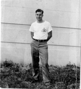
- Gerald F. Sanders stands on grass at the back of the family's house on Spruce Street. He wears pants and a t-shirt with RCAF insignia.
- Repository
- Burnaby Village Museum
- Collection/Fonds
- Gerald F. Sanders and Alice Sparman Sanders fonds
- Description Level
- Item
- Physical Description
- 1 photograph : b&w ; 4.5 x 4 cm
- Material Details
- Text in blue ink on verso "GFSANDERS. / 1942 AIRFORCE / ST THOMAS. / ONTARIO."
- Scope and Content
- Gerald F. Sanders stands on grass at the back of the family's house on Spruce Street. He wears pants and a t-shirt with RCAF insignia.
- Subjects
- Wars - World War, 1939-1945
- Names
- Sanders, Gerald Frank
- Geographic Access
- Spruce Street
- Street Address
- 4092 Spruce Street
- Accession Code
- BV018.34.26
- Access Restriction
- No restrictions
- Reproduction Restriction
- No known restrictions
- Date
- 1942
- Media Type
- Photograph
- Historic Neighbourhood
- Broadview (Historic Neighbourhood)
- Planning Study Area
- Cascade-Schou Area
- Scan Resolution
- 600
- Scan Date
- 2022-07-12
- Notes
- Title based on contents of photograph
Images

Healthcare workers outside of Burnaby General Hospital
https://search.heritageburnaby.ca/link/museumdescription14753
- Repository
- Burnaby Village Museum
- Date
- 12 May 2020
- Collection/Fonds
- Burnaby Village Museum COVID-19 collection
- Description Level
- Item
- Physical Description
- 1 photograph (jpg) : col. ; 144 dpi.
- Scope and Content
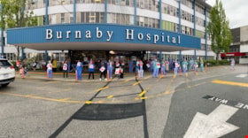
- Panorama photograph of Burnaby General Hospital with healthcare workers standing out in front holding heart posters. This was part of the salute to health care workers event at Burnaby General Hospital.
- Repository
- Burnaby Village Museum
- Collection/Fonds
- Burnaby Village Museum COVID-19 collection
- Description Level
- Item
- Physical Description
- 1 photograph (jpg) : col. ; 144 dpi.
- Scope and Content
- Panorama photograph of Burnaby General Hospital with healthcare workers standing out in front holding heart posters. This was part of the salute to health care workers event at Burnaby General Hospital.
- History
- Photograph was taken by Richard Liu on May 12, 2020 around 7:00pm. Richard helped organize a 'stick-tap' to salute front line health care workers at the Burnaby Hospital. The Vancouer Canuck's mascot "Fin", Mayor of Burnaby Mike Hurley, MLA Anne Kang and MLA Katrina Chen, MP Peter Juilan, the RCMP Chief, the Fire Chief and Transit Police Chief were in attendance. These 'salutes' to health care workers were common in April and May during the earliest and most uncertain months of the COVID-19 pandemic. Many local neighbourhoods across Burnaby, the Lower Mainland and the Province began regularly gathering at 7:00pm to bang pots and pans, honk horns, and generally celebrate and acknowledge the work of health care professionals. The presence of "Fin" was added because the Vancouver Canuck and NHL were not playing, so Fin was available to make the rounds. His visits were often surprises. Fin played the Canucks goal horn through the Fin Mobile roof speakers, with green and blue flashing lights. Fin visited six hospitals, as well as Canuck Place Children’s Hospice.
- Subjects
- Buildings - Civic - Hospitals
- Occupations - Nurses
- Occupations - Physicians
- Public Services - Health Services
- Pandemics - COVID-19
- Names
- Burnaby General Hospital
- Geographic Access
- Ingleton Avenue
- Street Address
- 3880 Ingleton Avenue
- Accession Code
- BV020.18.4
- Access Restriction
- No restrictions
- Reproduction Restriction
- No known restrictions
- Date
- 12 May 2020
- Media Type
- Photograph
- Historic Neighbourhood
- Broadview (Historic Neighbourhood)
- Planning Study Area
- Cascade-Schou Area
- Photographer
- Liu, Richard
- Notes
- Title based on contents of photograph
Images

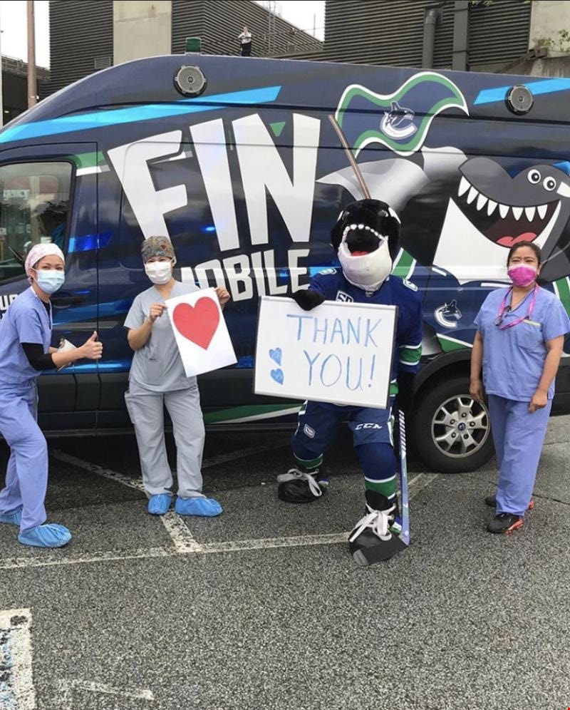
Healthcare workers with Vancouver Canucks mascot "Fin"
https://search.heritageburnaby.ca/link/museumdescription14754
- Repository
- Burnaby Village Museum
- Date
- 12 May 2020
- Collection/Fonds
- Burnaby Village Museum COVID-19 collection
- Description Level
- Item
- Physical Description
- 1 photograph (jpg) : col. ; 144 dpi.
- Scope and Content
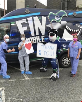
- Photograph of three healthcare workers posing with Vancouver Canucks mascot "Fin the Whale" outside of the Burnaby General Hospital. The three healthcare workers are are wearing scrubs and masks covering their mouths and noses and standing in front of the Canucks "FIN Mobile".
- Repository
- Burnaby Village Museum
- Collection/Fonds
- Burnaby Village Museum COVID-19 collection
- Description Level
- Item
- Physical Description
- 1 photograph (jpg) : col. ; 144 dpi.
- Scope and Content
- Photograph of three healthcare workers posing with Vancouver Canucks mascot "Fin the Whale" outside of the Burnaby General Hospital. The three healthcare workers are are wearing scrubs and masks covering their mouths and noses and standing in front of the Canucks "FIN Mobile".
- History
- Photograph was taken by Richard Liu on May 12, 2020 around 7:00pm. Richard helped organize a 'stick-tap' to salute front line health care workers at the Burnaby Hospital. The Vancouer Canuck's mascot "Fin", Mayor of Burnaby Mike Hurley, MLA Anne Kang and MLA Katrina Chen, MP Peter Juilan, the RCMP Chief, the Fire Chief and Transit Police Chief were in attendance. These 'salutes' to health care workers were common in April and May during the earliest and most uncertain months of the COVID-19 pandemic. Many local neighbourhoods across Burnaby, the Lower Mainland and the Province began regularly gathering at 7:00pm to bang pots and pans, honk horns, and generally celebrate and acknowledge the work of health care professionals. The presence of "Fin" was added because the Vancouver Canuck and NHL were not playing, so Fin was available to make the rounds. His visits were often surprises. Fin played the Canucks goal horn through the Fin Mobile roof speakers, with green and blue flashing lights. Fin visited six hospitals, as well as Canuck Place Children’s Hospice.
- Subjects
- Buildings - Civic - Hospitals
- Public Services - Health Services
- Occupations - Fire Fighters
- Occupations - Nurses
- Occupations - Physicians
- Pandemics - COVID-19
- Geographic Access
- Ingleton Avenue
- Street Address
- 3880 Ingleton Avenue
- Accession Code
- BV020.18.5
- Access Restriction
- No restrictions
- Reproduction Restriction
- No known restrictions
- Date
- 12 May 2020
- Media Type
- Photograph
- Historic Neighbourhood
- Broadview (Historic Neighbourhood)
- Planning Study Area
- Cascade-Schou Area
- Photographer
- Liu, Richard
- Notes
- Title based on contents of photograph
Images
Interview with Janet White May 10, 2005 - Track 1
https://search.heritageburnaby.ca/link/museumdescription4370
- Repository
- Burnaby Village Museum
- Date
- [195-] (interview content), interviewed May 10, 2005
- Collection/Fonds
- Burnaby Village Museum fonds
- Description Level
- Item
- Physical Description
- 1 sound recording (mp3) (0:03:12 min)
- Scope and Content
- Track 1: This portion of the recording pertains to Janet White’s school years and the activities and sports she participated in, formally and informally. She lived near 6th and Edmonds St., and then in the Cascades area, by Nithsdale St., and attended Schou Elementary. She attended many schools as …
- Repository
- Burnaby Village Museum
- Collection/Fonds
- Burnaby Village Museum fonds
- Series
- Museum Oral Histories series
- Subseries
- Growing Up in Burnaby subseries
- Description Level
- Item
- Physical Description
- 1 sound recording (mp3) (0:03:12 min)
- Material Details
- Interviewer: Tom Gooden Interviewee: Janet White Date of interview: May 10, 2005 Total Number of Tracks: 8 Total length of all Tracks: 0:31:34
- Scope and Content
- Track 1: This portion of the recording pertains to Janet White’s school years and the activities and sports she participated in, formally and informally. She lived near 6th and Edmonds St., and then in the Cascades area, by Nithsdale St., and attended Schou Elementary. She attended many schools as soon as they were built, attending Gilmore Avenue, then Cascade Heights, Alpha Junior High, Moscrop Secondary, and finally Burnaby Central Secondary. Play was unstructured, with the Cascades bush and the tunnel parallel to and going under Smith Avenue being favourite places to play.
- History
- Recording of an interview with Janet White recording by Tom Gooden on May 10 2005. This recording was completed for an exhibit, Growing Up in Burnaby, for the Burnaby Village Museum. Major themes discussed are growing up in Burnaby in the 1950s.
- Creator
- Burnaby Village Museum
- Names
- Gooden, Tom
- White, Janet
- Schou Street School
- Gilmore Avenue School
- Cascade Heights Elementary School
- Alpha Secondary School
- Moscrop Secondary School
- Burnaby Central Secondary School
- Geographic Access
- 6th Street
- Edmonds Street
- Accession Code
- BV017.45.1
- Access Restriction
- No restrictions
- Reproduction Restriction
- May be restricted by third party rights
- Date
- [195-] (interview content), interviewed May 10, 2005
- Media Type
- Sound Recording
- Planning Study Area
- Cascade-Schou Area
Audio Tracks
Interview with Janet White May 10, 2005 - Track 1, [195-] (interview content), interviewed May 10, 2005
Interview with Janet White May 10, 2005 - Track 1, [195-] (interview content), interviewed May 10, 2005
https://search.heritageburnaby.ca/media/hpo/_Data/_BVM_Sound_Recordings/Oral_Histories/2017_0045_0001_001.mp3
Municipality of Burnaby - Volume XVI and Volume XVII
https://search.heritageburnaby.ca/link/museumdescription8684
- Repository
- Burnaby Village Museum
- Date
- May 1927
- Collection/Fonds
- Burnaby Village Museum Map collection
- Description Level
- File
- Physical Description
- 4 plans on 4 sheets : col. lithographic prints ; 63.5 x 53.5 cm folded to 53 x 31.5 cm
- Scope and Content
- File consists of four pages of plans removed from a bound book containing a series of fire insurance plans of the Municipality of Burnaby. Page "D" is titled: "GREATER VANCOUVER B.C. / VOLUME XVI / Surveyed _ May 1927 / MUNICIPALITY OF / BURNABY / PLAN DEPT. FIRE BRANCH _ B.C. INSURANCE UNDERWRITE…
- Repository
- Burnaby Village Museum
- Collection/Fonds
- Burnaby Village Museum Map collection
- Description Level
- File
- Physical Description
- 4 plans on 4 sheets : col. lithographic prints ; 63.5 x 53.5 cm folded to 53 x 31.5 cm
- Material Details
- Scale [1:1200] and [1:6000]
- Scope and Content
- File consists of four pages of plans removed from a bound book containing a series of fire insurance plans of the Municipality of Burnaby. Page "D" is titled: "GREATER VANCOUVER B.C. / VOLUME XVI / Surveyed _ May 1927 / MUNICIPALITY OF / BURNABY / PLAN DEPT. FIRE BRANCH _ B.C. INSURANCE UNDERWRITERS ASSN." / KEY PLAN". Plans covered in this "Key Plan" are numbered 1601 to 1626, 1632 and 1651 covering District Lots: 15; 31; 100 to 102; 114; 141 to 144; 147 and 148; 209 to 214. Plan "E" is part of "GREATER VANCOUVER B.C. / VOLUME XVII / Municipality of Burnaby / May 1927" and covers plans: 1701 to 1705; 1711 to 1715; 1723 to 1727; 1729 to 1733; 1737 to 1742 and District Lots: 68 to 74; 80 to 84; 32 to 35 and 38 to 39. Plan marked "F" is a key plan titled: "GREATER VANCOUVER B.C. / VOLUME XVII / Surveyed _ May 1927 / MUNICIPALITY OF / BURNABY and covers plans: 1706 to 1710; 1716 to 1722; 1734 and 1735; 1743 to 1752 and District Lots: 42 to 44; 59; 75 to 80; 83 to 87; 89 to 93 and 130. Plan "1729" is part of "GREATER VANCOUVER B.C. / VOLUME XVII / Municipality of Burnaby / May 1927" and covers District Lots 34 and 35.
- Responsibility
- British Columbia Underwriters' Association
- Accession Code
- HV972.111.6
- Access Restriction
- No restrictions
- Reproduction Restriction
- May be restricted by third party rights
- Date
- May 1927
- Media Type
- Cartographic Material
- Historic Neighbourhood
- Barnet (Historic Neighbourhood)
- Burquitlam (Historic Neighbourhood)
- Central Park (Historic Neighbourhood)
- Burnaby Lake (Historic Neighbourhood)
- Broadview (Historic Neighbourhood)
- Planning Study Area
- Burnaby Mountain Area
- Lyndhurst Area
- Lake City Area
- Cascade-Schou Area
- Garden Village Area
- Douglas-Gilpin Area
- Oakalla Area
- Scan Resolution
- 400
- Scan Date
- 2021-11-18
- Notes
- Title based on content of plans
- See also BV987.1.70d for revised versions of plans
- Scale is measured 1 inch = 500 feet
Zoomable Images


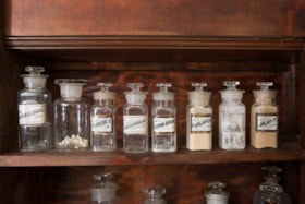
pharmaceutical bottle
https://search.heritageburnaby.ca/link/museumartifact2640
- Repository
- Burnaby Village Museum
- Accession Code
- HV971.165.1
- Description
- The item is a bulk product stocked by a pharmacy. Up until the 1950s, pharmacists provided most prescription medications by creating compounds of bulk products that were given to customers as pills, salves, or tonics. Clear glass bottle with glass stopper and LUG (label under glass). Half full with beige powder. Bottle is square based.
- Object History
- This item originates from the Sunset Pharmacy in Burnaby.
- Classification
- Chemical T&E
- Marks/Labels
- marked "JALAP.P." Black text on white label with gold and red trim.
- Names
- Sunset Pharmacy
- Historic Neighbourhood
- Broadview (Historic Neighbourhood)
- Planning Study Area
- Cascade-Schou Area
Images


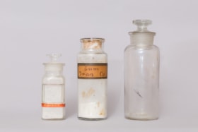
pharmaceutical bottle
https://search.heritageburnaby.ca/link/museumartifact2644
- Repository
- Burnaby Village Museum
- Accession Code
- HV971.165.5
- Description
- The item is a bulk product stocked by a pharmacy. Up until the 1950s, pharmacists provided most prescription medications by creating compounds of bulk products that were given to customers as pills, salves, or tonics. Small, clear glass stopper bottle, rounded base, with flat glass stopper. The bottle contains liquid and solid residue, yellow and brown in colour. Residue is heavily concentrated at the neck and in the bottom of the bottle. There is no label attached. Small pink piece of paper is attached with tape near base of the bottle.
- Object History
- This item originates from the Sunset Pharmacy in Burnaby.
- Classification
- Chemical T&E
- Names
- Sunset Pharmacy
- Historic Neighbourhood
- Broadview (Historic Neighbourhood)
- Planning Study Area
- Cascade-Schou Area
Images

pharmaceutical bottle
https://search.heritageburnaby.ca/link/museumartifact2646
- Repository
- Burnaby Village Museum
- Accession Code
- HV971.165.7
- Description
- The item is a bulk product stocked by a pharmacy. Up until the 1950s, pharmacists provided most prescription medications by creating compounds of bulk products that were given to customers as pills, salves, or tonics. Square glass stopper bottle. No label. Remnant of a red label "POISON". Has a powder residue
- Object History
- This item originates from the Sunset Pharmacy in Burnaby.
- Classification
- Chemical T&E
- Marks/Labels
- No label, but rectangular indentation in bottle where one could be applied. Remnant of a red label "POISON".
- Names
- Sunset Pharmacy
- Historic Neighbourhood
- Broadview (Historic Neighbourhood)
- Planning Study Area
- Cascade-Schou Area
Images

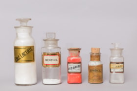
pharmaceutical bottle
https://search.heritageburnaby.ca/link/museumartifact2653
- Repository
- Burnaby Village Museum
- Accession Code
- HV971.165.14
- Description
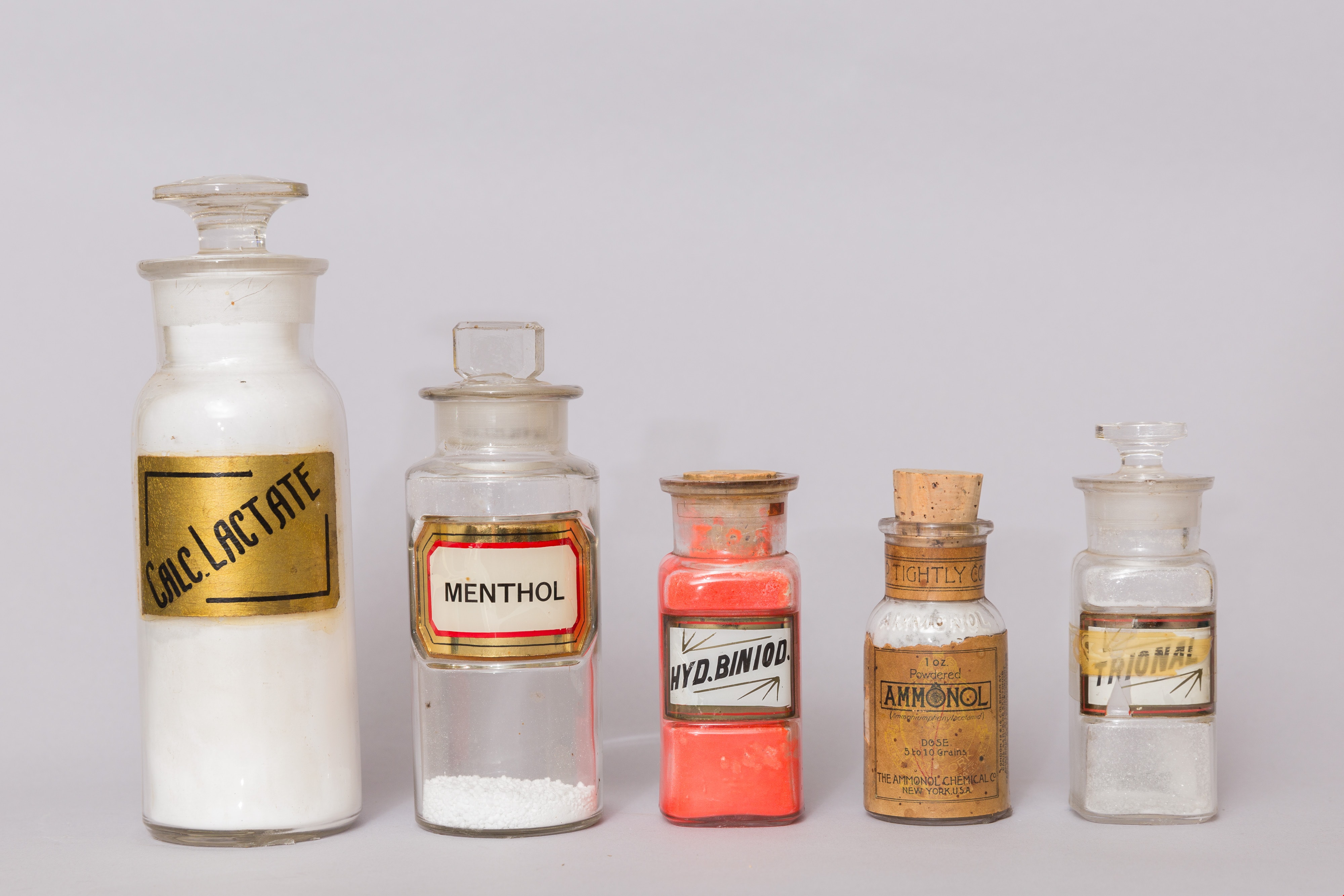
- The item is a bulk product stocked by a pharmacy. Up until the 1950s, pharmacists provided most prescription medications by creating compounds of bulk products that were given to customers as pills, salves, or tonics. A square, clear glass bottle with a cork stopper. Label under glass (LUG). Labelled "HYD. BINOID. Full of bright pink/red powder.
- Object History
- This item originates from the Sunset Pharmacy in Burnaby.
- Classification
- Chemical T&E
- Marks/Labels
- Label under glass (LUG). White label with black print trimmed in red and gold. Labelled "HYD. BINOID."
- Names
- Sunset Pharmacy
- Historic Neighbourhood
- Broadview (Historic Neighbourhood)
- Planning Study Area
- Cascade-Schou Area
Images