Narrow Results By
Subject
- Advertising Medium - Signs and Signboards 13
- Aerial Photographs 1
- Agriculture - Farms 1
- Arts 2
- Arts - Drawings 1
- Buildings - Civic - Libraries 1
- Buildings - Commercial - Barber Shops 1
- Buildings - Commercial - Beauty Shops 2
- Buildings - Commercial - Drugstores 1
- Buildings - Commercial - Grocery Stores 3
- Buildings - Commercial - Hotels and Motels 1
- Buildings - Commercial - Restaurants 2
Person / Organization
- A & Aero Trading Salvage 1
- Astor Hotel 1
- Barnet Rifle Club 4
- Big O Tire Store 1
- British Columbia Institute of Technology 2
- Burnaby Automotive 1
- Burnaby Cleaners 1
- Burnaby Fish and Game Club 1
- Burnaby Mountain Autobody 1
- Burnaby North Baptist Church 1
- Burnaby Public Library 1
- Burnaby Village Museum 1
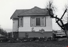
House at 5250 Claude Avenue
https://search.heritageburnaby.ca/link/archivedescription78888
- Repository
- City of Burnaby Archives
- Date
- February 7, 1977
- Collection/Fonds
- Burnaby Public Library Contemporary Visual Archive Project
- Description Level
- Item
- Physical Description
- 1 photograph : b&w ; 11 x 16 cm mounted on cardboard
- Scope and Content
- Photograph shows the house at 5250 Claude Avenue, with Christmas decorations on the wall.
- Repository
- City of Burnaby Archives
- Date
- February 7, 1977
- Collection/Fonds
- Burnaby Public Library Contemporary Visual Archive Project
- Physical Description
- 1 photograph : b&w ; 11 x 16 cm mounted on cardboard
- Description Level
- Item
- Record No.
- 556-015
- Access Restriction
- No restrictions
- Reproduction Restriction
- Reproduce for fair dealing purposes only
- Accession Number
- 2013-13
- Scope and Content
- Photograph shows the house at 5250 Claude Avenue, with Christmas decorations on the wall.
- Subjects
- Holidays - Christmas
- Media Type
- Photograph
- Notes
- Scope note taken directly from BPL photograph description.
- 1 b&w copy negative : 10 x 12.5 cm accompanying
- Photographers identified by surnames only: Carr and Vardeman
- Geographic Access
- Claude Avenue
- Street Address
- 5250 Claude Avenue
- Historic Neighbourhood
- Burnaby Lake (Historic Neighbourhood)
- Planning Study Area
- Morley-Buckingham Area
Images


House at 7945 12th Avenue
https://search.heritageburnaby.ca/link/archivedescription78890
- Repository
- City of Burnaby Archives
- Date
- February 7, 1977
- Collection/Fonds
- Burnaby Public Library Contemporary Visual Archive Project
- Description Level
- Item
- Physical Description
- 1 photograph : b&w ; 11 x 16 cm mounted on cardboard
- Scope and Content
- Photograph shows the house at 7945 12th Avenue.
- Repository
- City of Burnaby Archives
- Date
- February 7, 1977
- Collection/Fonds
- Burnaby Public Library Contemporary Visual Archive Project
- Physical Description
- 1 photograph : b&w ; 11 x 16 cm mounted on cardboard
- Description Level
- Item
- Record No.
- 556-016
- Access Restriction
- No restrictions
- Reproduction Restriction
- Reproduce for fair dealing purposes only
- Accession Number
- 2013-13
- Scope and Content
- Photograph shows the house at 7945 12th Avenue.
- Media Type
- Photograph
- Notes
- Scope note taken directly from BPL photograph description.
- 1 b&w copy negative : 10 x 12.5 cm accompanying
- Photographers identified by surnames only: Carr and Vardeman
- Geographic Access
- 12th Avenue
- Street Address
- 7945 12th Avenue
- Historic Neighbourhood
- East Burnaby (Historic Neighbourhood)
- Planning Study Area
- Second Street Area
Images


House at 7700 Haszard Street
https://search.heritageburnaby.ca/link/archivedescription78891
- Repository
- City of Burnaby Archives
- Date
- February 7, 1977
- Collection/Fonds
- Burnaby Public Library Contemporary Visual Archive Project
- Description Level
- Item
- Physical Description
- 1 photograph : b&w ; 11 x 16 cm mounted on cardboard
- Scope and Content
- Photograph shows the house and farm yard at 7700 Haszard Street, near Caanda Way.
- Repository
- City of Burnaby Archives
- Date
- February 7, 1977
- Collection/Fonds
- Burnaby Public Library Contemporary Visual Archive Project
- Physical Description
- 1 photograph : b&w ; 11 x 16 cm mounted on cardboard
- Description Level
- Item
- Record No.
- 556-017
- Access Restriction
- No restrictions
- Reproduction Restriction
- Reproduce for fair dealing purposes only
- Accession Number
- 2013-13
- Scope and Content
- Photograph shows the house and farm yard at 7700 Haszard Street, near Caanda Way.
- Subjects
- Agriculture - Farms
- Media Type
- Photograph
- Notes
- Scope note taken directly from BPL photograph description.
- 1 b&w copy negative : 10 x 12.5 cm accompanying
- Photographers identified by surnames only: Carr and Vardeman
- Geographic Access
- Haszard Street
- Street Address
- 7700 Haszard Street
- Historic Neighbourhood
- Burnaby Lake (Historic Neighbourhood)
- Planning Study Area
- Morley-Buckingham Area
Images


Corner of Buxton and Royal Oak
https://search.heritageburnaby.ca/link/archivedescription78895
- Repository
- City of Burnaby Archives
- Date
- February 7, 1977
- Collection/Fonds
- Burnaby Public Library Contemporary Visual Archive Project
- Description Level
- Item
- Physical Description
- 1 photograph : b&w ; 11 x 16 cm mounted on cardboard
- Scope and Content
- Photograph shows a house on the corner of Buxton Street and Royal Oak Avenue with a view of north Burnaby and the North Shore in the background.
- Repository
- City of Burnaby Archives
- Date
- February 7, 1977
- Collection/Fonds
- Burnaby Public Library Contemporary Visual Archive Project
- Physical Description
- 1 photograph : b&w ; 11 x 16 cm mounted on cardboard
- Description Level
- Item
- Record No.
- 556-020
- Access Restriction
- No restrictions
- Reproduction Restriction
- Reproduce for fair dealing purposes only
- Accession Number
- 2013-13
- Scope and Content
- Photograph shows a house on the corner of Buxton Street and Royal Oak Avenue with a view of north Burnaby and the North Shore in the background.
- Media Type
- Photograph
- Notes
- Scope note taken directly from BPL photograph description.
- 1 b&w copy negative : 10 x 12.5 cm accompanying
- Photographers identified by surnames only: Carr and Vardeman
- Geographic Access
- Buxton Street
- Royal Oak Avenue
- Historic Neighbourhood
- Central Park (Historic Neighbourhood)
- Planning Study Area
- Marlborough Area
Images

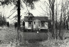
House at 4914 Sperling Avenue
https://search.heritageburnaby.ca/link/archivedescription78898
- Repository
- City of Burnaby Archives
- Date
- February 7, 1977
- Collection/Fonds
- Burnaby Public Library Contemporary Visual Archive Project
- Description Level
- Item
- Physical Description
- 1 photograph : b&w ; 11 x 16 cm mounted on cardboard
- Scope and Content
- Photograph shows a house in a natural setting at 4914 Sperling Avenue.
- Repository
- City of Burnaby Archives
- Date
- February 7, 1977
- Collection/Fonds
- Burnaby Public Library Contemporary Visual Archive Project
- Physical Description
- 1 photograph : b&w ; 11 x 16 cm mounted on cardboard
- Description Level
- Item
- Record No.
- 556-022
- Access Restriction
- No restrictions
- Reproduction Restriction
- Reproduce for fair dealing purposes only
- Accession Number
- 2013-13
- Scope and Content
- Photograph shows a house in a natural setting at 4914 Sperling Avenue.
- Media Type
- Photograph
- Notes
- Scope note taken directly from BPL photograph description.
- 1 b&w copy negative : 10 x 12.5 cm accompanying
- Photographers identified by surnames only: Carr and Vardeman
- Geographic Access
- Sperling Avenue
- Street Address
- 4914 Sperling Avenue
- Historic Neighbourhood
- Burnaby Lake (Historic Neighbourhood)
- Planning Study Area
- Morley-Buckingham Area
Images
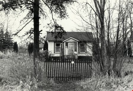
House at 5750 Rayside Avenue
https://search.heritageburnaby.ca/link/archivedescription78910
- Repository
- City of Burnaby Archives
- Date
- February 7, 1977
- Collection/Fonds
- Burnaby Public Library Contemporary Visual Archive Project
- Description Level
- Item
- Physical Description
- 1 photograph : b&w ; 11 x 16 cm mounted on cardboard
- Scope and Content
- Photograph shows an old house and car at 5750 Rayside Avenue.
- Repository
- City of Burnaby Archives
- Date
- February 7, 1977
- Collection/Fonds
- Burnaby Public Library Contemporary Visual Archive Project
- Physical Description
- 1 photograph : b&w ; 11 x 16 cm mounted on cardboard
- Description Level
- Item
- Record No.
- 556-028
- Access Restriction
- No restrictions
- Reproduction Restriction
- Reproduce for fair dealing purposes only
- Accession Number
- 2013-13
- Scope and Content
- Photograph shows an old house and car at 5750 Rayside Avenue.
- Subjects
- Transportation - Automobiles
- Media Type
- Photograph
- Notes
- Scope note taken directly from BPL photograph description.
- 1 b&w copy negative : 10 x 12.5 cm accompanying
- Photographers identified by surnames only: Carr and Vardeman
- Geographic Access
- Rayside Street
- Street Address
- 5750 Rayside Street
- Historic Neighbourhood
- Burnaby Lake (Historic Neighbourhood)
- Planning Study Area
- Morley-Buckingham Area
Images


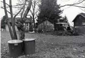
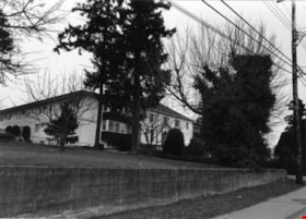
6100 Block McMurray Avenue
https://search.heritageburnaby.ca/link/archivedescription78912
- Repository
- City of Burnaby Archives
- Date
- February 7, 1977
- Collection/Fonds
- Burnaby Public Library Contemporary Visual Archive Project
- Description Level
- Item
- Physical Description
- 1 photograph : b&w ; 11 x 16 cm mounted on cardboard
- Scope and Content
- Photograph shows houses on 6100 Block McMurray Avenue, near Grange Street.
- Repository
- City of Burnaby Archives
- Date
- February 7, 1977
- Collection/Fonds
- Burnaby Public Library Contemporary Visual Archive Project
- Physical Description
- 1 photograph : b&w ; 11 x 16 cm mounted on cardboard
- Description Level
- Item
- Record No.
- 556-029
- Access Restriction
- No restrictions
- Reproduction Restriction
- Reproduce for fair dealing purposes only
- Accession Number
- 2013-13
- Scope and Content
- Photograph shows houses on 6100 Block McMurray Avenue, near Grange Street.
- Media Type
- Photograph
- Notes
- Scope note taken directly from BPL photograph description.
- 1 b&w copy negative : 10 x 12.5 cm accompanying
- Photographers identified by surnames only: Carr and Vardeman
- Geographic Access
- McMurray Avenue
- Historic Neighbourhood
- Central Park (Historic Neighbourhood)
- Planning Study Area
- Marlborough Area
Images


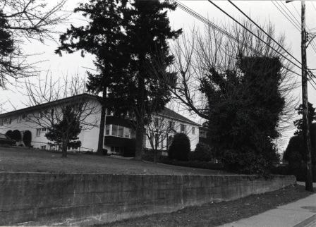
House at 6236 McMurray Avenue
https://search.heritageburnaby.ca/link/archivedescription78918
- Repository
- City of Burnaby Archives
- Date
- February 7, 1977
- Collection/Fonds
- Burnaby Public Library Contemporary Visual Archive Project
- Description Level
- Item
- Physical Description
- 1 photograph : b&w ; 11 x 16 cm mounted on cardboard
- Scope and Content
- Photograph shows cars in front of a house located at 6236 McMurray Avenue with a high-rise apartment building in the background.
- Repository
- City of Burnaby Archives
- Date
- February 7, 1977
- Collection/Fonds
- Burnaby Public Library Contemporary Visual Archive Project
- Physical Description
- 1 photograph : b&w ; 11 x 16 cm mounted on cardboard
- Description Level
- Item
- Record No.
- 556-033
- Access Restriction
- No restrictions
- Reproduction Restriction
- Reproduce for fair dealing purposes only
- Accession Number
- 2013-13
- Scope and Content
- Photograph shows cars in front of a house located at 6236 McMurray Avenue with a high-rise apartment building in the background.
- Media Type
- Photograph
- Notes
- Scope note taken directly from BPL photograph description.
- 1 b&w copy negative : 10 x 12.5 cm accompanying
- Photographers identified by surnames only: Carr and Vardeman
- Geographic Access
- McMurray Avenue
- Street Address
- 6236 McMurray Avenue
- Historic Neighbourhood
- Central Park (Historic Neighbourhood)
- Planning Study Area
- Marlborough Area
Images

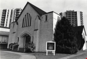
West Burnaby United Church
https://search.heritageburnaby.ca/link/archivedescription79067
- Repository
- City of Burnaby Archives
- Date
- February 7, 1977
- Collection/Fonds
- Burnaby Public Library Contemporary Visual Archive Project
- Description Level
- Item
- Physical Description
- 1 photograph : b&w ; 11 x 16 cm mounted on cardboard
- Scope and Content
- Photograph shows the West Burnaby United Church located at 6050 Sussex Avenue on the corner of Sussex and Hazel Street.
- Repository
- City of Burnaby Archives
- Date
- February 7, 1977
- Collection/Fonds
- Burnaby Public Library Contemporary Visual Archive Project
- Physical Description
- 1 photograph : b&w ; 11 x 16 cm mounted on cardboard
- Description Level
- Item
- Record No.
- 556-130
- Access Restriction
- No restrictions
- Reproduction Restriction
- Reproduce for fair dealing purposes only
- Accession Number
- 2013-13
- Scope and Content
- Photograph shows the West Burnaby United Church located at 6050 Sussex Avenue on the corner of Sussex and Hazel Street.
- Subjects
- Buildings - Religious - Churches
- Media Type
- Photograph
- Notes
- Scope note taken directly from BPL photograph description.
- 1 b&w copy negative : 10 x 12.5 cm accompanying
- Photographers identified by surnames only: Carr and Vardeman
- Geographic Access
- Sussex Avenue
- Street Address
- 6050 Sussex Avenue
- Historic Neighbourhood
- Central Park (Historic Neighbourhood)
- Planning Study Area
- Marlborough Area
Images

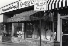
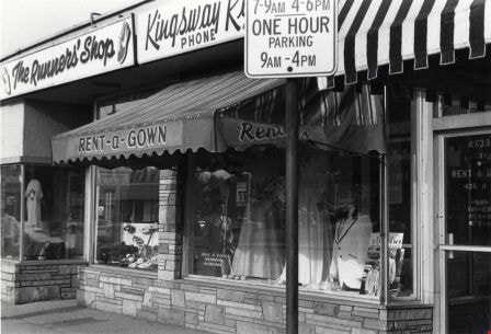
The Runners' Shop
https://search.heritageburnaby.ca/link/archivedescription79168
- Repository
- City of Burnaby Archives
- Date
- February 7, 1977
- Collection/Fonds
- Burnaby Public Library Contemporary Visual Archive Project
- Description Level
- Item
- Physical Description
- 1 photograph : b&w ; 11 x 16 cm mounted on cardboard
- Scope and Content
- Photograph shows the Runners' Shop at 4635 Kingsway and Kingsway Rent-a-Gown at 4639 Kingsway.
- Repository
- City of Burnaby Archives
- Date
- February 7, 1977
- Collection/Fonds
- Burnaby Public Library Contemporary Visual Archive Project
- Physical Description
- 1 photograph : b&w ; 11 x 16 cm mounted on cardboard
- Description Level
- Item
- Record No.
- 556-186
- Access Restriction
- No restrictions
- Reproduction Restriction
- Reproduce for fair dealing purposes only
- Accession Number
- 2013-13
- Scope and Content
- Photograph shows the Runners' Shop at 4635 Kingsway and Kingsway Rent-a-Gown at 4639 Kingsway.
- Media Type
- Photograph
- Notes
- Scope note taken directly from BPL photograph description.
- 1 b&w copy negative : 10 x 12.5 cm accompanying
- Photographers identified by surnames only: Carr and Vardeman
- Geographic Access
- Kingsway
- Street Address
- 4635 Kingsway
- 4639 Kingsway
- Historic Neighbourhood
- Central Park (Historic Neighbourhood)
- Planning Study Area
- Marlborough Area
Images

4700 Block Kingsway
https://search.heritageburnaby.ca/link/archivedescription79227
- Repository
- City of Burnaby Archives
- Date
- February 7, 1977
- Collection/Fonds
- Burnaby Public Library Contemporary Visual Archive Project
- Description Level
- Item
- Physical Description
- 1 photograph : b&w ; 11 x 16 cm mounted on cardboard
- Scope and Content
- Photograph shows small businesses in the 4700 block Kingsway looking east along Kingsway. Businesses include William's Cafe, Fire Places Unlimited and Vacuum Self-Service.
- Repository
- City of Burnaby Archives
- Date
- February 7, 1977
- Collection/Fonds
- Burnaby Public Library Contemporary Visual Archive Project
- Physical Description
- 1 photograph : b&w ; 11 x 16 cm mounted on cardboard
- Description Level
- Item
- Record No.
- 556-210
- Access Restriction
- No restrictions
- Reproduction Restriction
- Reproduce for fair dealing purposes only
- Accession Number
- 2013-13
- Scope and Content
- Photograph shows small businesses in the 4700 block Kingsway looking east along Kingsway. Businesses include William's Cafe, Fire Places Unlimited and Vacuum Self-Service.
- Media Type
- Photograph
- Notes
- Scope note taken directly from BPL photograph description.
- 1 b&w copy negative : 10 x 12.5 cm accompanying
- Photographers identified by surnames only: Carr and Vardeman
- Geographic Access
- Kingsway
- Historic Neighbourhood
- Central Park (Historic Neighbourhood)
- Planning Study Area
- Marlborough Area
Images


Closed Gas Station
https://search.heritageburnaby.ca/link/archivedescription79271
- Repository
- City of Burnaby Archives
- Date
- February 7, 1977
- Collection/Fonds
- Burnaby Public Library Contemporary Visual Archive Project
- Description Level
- Item
- Physical Description
- 1 photograph : b&w ; 11 x 16 cm mounted on cardboard
- Scope and Content
- Photograph shows a closed gas station on Kingsway near McKercher Avenue.
- Repository
- City of Burnaby Archives
- Date
- February 7, 1977
- Collection/Fonds
- Burnaby Public Library Contemporary Visual Archive Project
- Physical Description
- 1 photograph : b&w ; 11 x 16 cm mounted on cardboard
- Description Level
- Item
- Record No.
- 556-233
- Access Restriction
- No restrictions
- Reproduction Restriction
- Reproduce for fair dealing purposes only
- Accession Number
- 2013-13
- Scope and Content
- Photograph shows a closed gas station on Kingsway near McKercher Avenue.
- Media Type
- Photograph
- Notes
- Scope note taken directly from BPL photograph description.
- 1 b&w copy negative : 10 x 12.5 cm accompanying
- Photographers identified by surnames only: Carr and Vardeman
- Geographic Access
- McKercher Avenue
- Kingsway
- Historic Neighbourhood
- Central Park (Historic Neighbourhood)
- Planning Study Area
- Marlborough Area
Images

Normanna Rest Home
https://search.heritageburnaby.ca/link/archivedescription79510
- Repository
- City of Burnaby Archives
- Date
- February 7, 1977
- Collection/Fonds
- Burnaby Public Library Contemporary Visual Archive Project
- Description Level
- Item
- Physical Description
- 1 photograph : b&w ; 11 x 16 cm mounted on cardboard
- Scope and Content
- Photograph shows the Normanna Rest Home at 7979 12th Avenue (later 7725 4th Street).
- Repository
- City of Burnaby Archives
- Date
- February 7, 1977
- Collection/Fonds
- Burnaby Public Library Contemporary Visual Archive Project
- Physical Description
- 1 photograph : b&w ; 11 x 16 cm mounted on cardboard
- Description Level
- Item
- Record No.
- 556-337
- Access Restriction
- No restrictions
- Reproduction Restriction
- Reproduce for fair dealing purposes only
- Accession Number
- 2013-13
- Scope and Content
- Photograph shows the Normanna Rest Home at 7979 12th Avenue (later 7725 4th Street).
- Names
- Normanna Rest Home
- Media Type
- Photograph
- Notes
- Scope note taken directly from BPL photograph description.
- 1 b&w copy negative : 10 x 12.5 cm accompanying
- Photographers identified by surnames only: Carr and Vardeman
- Geographic Access
- 4th Street
- Street Address
- 7725 4th Street
- Historic Neighbourhood
- East Burnaby (Historic Neighbourhood)
- Planning Study Area
- Second Street Area
Images
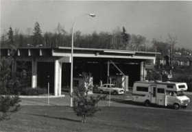
Motor Vehicle Inspection Station
https://search.heritageburnaby.ca/link/archivedescription79580
- Repository
- City of Burnaby Archives
- Date
- February 7, 1977
- Collection/Fonds
- Burnaby Public Library Contemporary Visual Archive Project
- Description Level
- Item
- Physical Description
- 1 photograph : b&w ; 11 x 16 cm mounted on cardboard
- Scope and Content
- Photograph shows the Motor Vehicle Inspection Station at 4705 Wayburne Drive.
- Repository
- City of Burnaby Archives
- Date
- February 7, 1977
- Collection/Fonds
- Burnaby Public Library Contemporary Visual Archive Project
- Physical Description
- 1 photograph : b&w ; 11 x 16 cm mounted on cardboard
- Description Level
- Item
- Record No.
- 556-343
- Access Restriction
- No restrictions
- Reproduction Restriction
- Reproduce for fair dealing purposes only
- Accession Number
- 2013-13
- Scope and Content
- Photograph shows the Motor Vehicle Inspection Station at 4705 Wayburne Drive.
- Media Type
- Photograph
- Notes
- Scope note taken directly from BPL photograph description.
- 1 b&w copy negative : 10 x 12.5 cm accompanying
- Photographers identified by surnames only: Carr and Vardeman
- Geographic Access
- Wayburne Drive
- Street Address
- 4705 Wayburne Drive
- Historic Neighbourhood
- Burnaby Lake (Historic Neighbourhood)
- Planning Study Area
- Douglas-Gilpin Area
Images
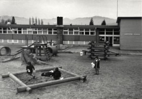
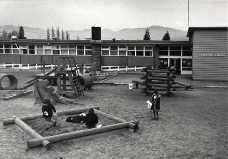
Lakeview Elementary School Playground
https://search.heritageburnaby.ca/link/archivedescription79612
- Repository
- City of Burnaby Archives
- Date
- February 7, 1977
- Collection/Fonds
- Burnaby Public Library Contemporary Visual Archive Project
- Description Level
- Item
- Physical Description
- 1 photograph : b&w ; 11 x 16 cm mounted on cardboard
- Scope and Content
- Photograph shows the playground at Lakeview Elementary School, 7777 Mayfield Street.
- Repository
- City of Burnaby Archives
- Date
- February 7, 1977
- Collection/Fonds
- Burnaby Public Library Contemporary Visual Archive Project
- Physical Description
- 1 photograph : b&w ; 11 x 16 cm mounted on cardboard
- Description Level
- Item
- Record No.
- 556-354
- Access Restriction
- No restrictions
- Reproduction Restriction
- Reproduce for fair dealing purposes only
- Accession Number
- 2013-13
- Scope and Content
- Photograph shows the playground at Lakeview Elementary School, 7777 Mayfield Street.
- Media Type
- Photograph
- Notes
- Scope note taken directly from BPL photograph description.
- 1 b&w copy negative : 10 x 12.5 cm accompanying
- Photographers identified by surnames only: Carr and Vardeman
- Geographic Access
- Mayfield Street
- Street Address
- 7777 Mayfield Street
- Planning Study Area
- Lakeview-Mayfield Area
Images

BCIT
https://search.heritageburnaby.ca/link/archivedescription79673
- Repository
- City of Burnaby Archives
- Date
- February 7, 1977
- Collection/Fonds
- Burnaby Public Library Contemporary Visual Archive Project
- Description Level
- Item
- Physical Description
- 1 photograph : b&w ; 11 x 16 cm mounted on cardboard
- Scope and Content
- Photograph shows the main entrance to the British Columbia Institute of Technology at 3700 Willingdon Avenue.
- Repository
- City of Burnaby Archives
- Date
- February 7, 1977
- Collection/Fonds
- Burnaby Public Library Contemporary Visual Archive Project
- Physical Description
- 1 photograph : b&w ; 11 x 16 cm mounted on cardboard
- Description Level
- Item
- Record No.
- 556-370
- Access Restriction
- No restrictions
- Reproduction Restriction
- Reproduce for fair dealing purposes only
- Accession Number
- 2013-13
- Scope and Content
- Photograph shows the main entrance to the British Columbia Institute of Technology at 3700 Willingdon Avenue.
- Subjects
- Buildings - Schools
- Media Type
- Photograph
- Notes
- Scope note taken directly from BPL photograph description.
- 1 b&w copy negative : 10 x 12.5 cm accompanying
- Photographers identified by surnames only: Carr and Vardeman
- Geographic Access
- Willingdon Avenue
- Street Address
- 3700 Willingdon Avenue
- Planning Study Area
- Douglas-Gilpin Area
Images

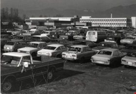
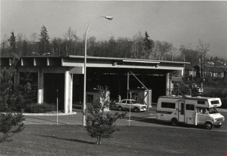
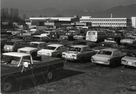
BCIT
https://search.heritageburnaby.ca/link/archivedescription79675
- Repository
- City of Burnaby Archives
- Date
- February 7, 1977
- Collection/Fonds
- Burnaby Public Library Contemporary Visual Archive Project
- Description Level
- Item
- Physical Description
- 1 photograph : b&w ; 11 x 16 cm mounted on cardboard
- Scope and Content
- Photograph shows vehicles in the BCIT parking lot off Wayburne Drive with the BCIT complex in the background.
- Repository
- City of Burnaby Archives
- Date
- February 7, 1977
- Collection/Fonds
- Burnaby Public Library Contemporary Visual Archive Project
- Physical Description
- 1 photograph : b&w ; 11 x 16 cm mounted on cardboard
- Description Level
- Item
- Record No.
- 556-371
- Access Restriction
- No restrictions
- Reproduction Restriction
- Reproduce for fair dealing purposes only
- Accession Number
- 2013-13
- Scope and Content
- Photograph shows vehicles in the BCIT parking lot off Wayburne Drive with the BCIT complex in the background.
- Media Type
- Photograph
- Notes
- Scope note taken directly from BPL photograph description.
- 1 b&w copy negative : 10 x 12.5 cm accompanying
- Photographers identified by surnames only: Carr and Vardeman
- Geographic Access
- Willingdon Avenue
- Wayburne Drive
- Street Address
- 3700 Willingdon Avenue
- Planning Study Area
- Douglas-Gilpin Area
Images
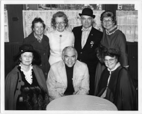
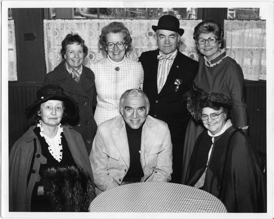
Lorne Greene with Heritage Village volunteers
https://search.heritageburnaby.ca/link/museumdescription4369
- Repository
- Burnaby Village Museum
- Date
- 4 Mar. 1977
- Collection/Fonds
- Century Park Museum Association fonds
- Description Level
- Item
- Physical Description
- 1 photograph : b&w ; 25.4 x 20.5 cm
- Scope and Content
- Photograph of actor Lorne Greene and Heritage Village volunteers (now Burnaby Village Museum). Mr. Greene is seated in the centre of the photograph, with two volunteers seated on either side of him, and four volunteers standing behind him. Mr. Greene was in the Village to film television commercial…
- Repository
- Burnaby Village Museum
- Collection/Fonds
- Century Park Museum Association fonds
- Description Level
- Item
- Physical Description
- 1 photograph : b&w ; 25.4 x 20.5 cm
- Material Details
- Handwritten text in black ink on back reads: "- Joan HarbordHarbord -Daphne Carr - Harold Carr - Betty / -Mary Hall - Lorne Green - Ruth Clee", "Taken at Heritage Village / March 4, 1977 with Village / volunteers & Lorne Greene / of "Bonanza" who was filming commercials / in the village for Bank of B.C.", and "LORNE TOOK US / TO GAI PARi FOR / LUNCH- VERY / NICE GUY!".
- Scope and Content
- Photograph of actor Lorne Greene and Heritage Village volunteers (now Burnaby Village Museum). Mr. Greene is seated in the centre of the photograph, with two volunteers seated on either side of him, and four volunteers standing behind him. Mr. Greene was in the Village to film television commercials for the Bank of British Columbia. The photograph appears to have been taken in the Ice Cream Parlour building.
- Subjects
- Occupations - Actors
- Names
- Burnaby Village Museum
- Geographic Access
- Deer Lake Drive
- Accession Code
- BV017.46.1
- Access Restriction
- No restrictions
- Reproduction Restriction
- May be restricted by third party rights
- Date
- 4 Mar. 1977
- Media Type
- Photograph
- Scan Resolution
- 300
- Scan Date
- 03-Apr-2018
- Notes
- Title based on contents of photograph
Images
William Harold Carr fonds
https://search.heritageburnaby.ca/link/museumdescription10136
- Repository
- Burnaby Village Museum
- Date
- 1977
- Collection/Fonds
- William Harold Carr fonds
- Description Level
- Fonds
- Physical Description
- 1 album (ca. 28 photographs)
- Scope and Content
- Fonds consists of a thirty three page photograph album documenting the building of an outhouse by Century Park Museum Association volunteer, Harold Carr on the site of Heritage Village in Century Park (Burnaby Village Museum). The album is titled: "THE EPIC OF THE / OUTHOUSE / The Only (Privy) Bif…
- Repository
- Burnaby Village Museum
- Collection/Fonds
- William Harold Carr fonds
- Description Level
- Fonds
- Physical Description
- 1 album (ca. 28 photographs)
- Material Details
- Pages include typewritten text pasted below each photograph
- Scope and Content
- Fonds consists of a thirty three page photograph album documenting the building of an outhouse by Century Park Museum Association volunteer, Harold Carr on the site of Heritage Village in Century Park (Burnaby Village Museum). The album is titled: "THE EPIC OF THE / OUTHOUSE / The Only (Privy) Biffy in Heritage Village with the Good Housekeeping / Seal of disApproval, 1977" / "Built by Mr. W. H. Carr / Privy Councillor / and Builder Emeritus". Photography by R. S. Banford & M. Smith, Marbo Photographics, North Vancouver."
- History
- William Harold Carr was the son of Mr. and Mrs. Joseph Carr of Vancouver. He and his twin brother, James Allen Carr, were born in Edmonton on June 18, 1917. Harold moved to Burnaby with his family (including his sisters, Muriel and Maisie) in 1924. His parents bought a lot in District Lot 94 and built a house at 3119 Royal Oak, (after 1958: 6270 Royal Oak Ave.). After World War II, Harold married Daphne Adel Withers on April 13, 1946 at Christ Church Cathedral in Vancouver. In 1946, the couple built a house at 2836 Pearl Avenue (Address after 1958: 6269 Pearl Ave.). The house was built on a portion of District Lot 94 that faced Pearl Street and was owned by Harold’s parents, Mr. and Mrs. Joseph Carr. Harold and Daphne had one child named Warren. Harold worked as an engineer for the CPR and prior to this he worked at Mohawk Lumber. Harold and his wife Daphne became involved with the Century Park Museum Association in the mid-1970s. Daphne volunteered to run the gift shop while Harold volunteered as an engineer on the model railway. Besides working on the model railway in Heritage Village, Harold also built a chicken coup and the outhouse located near Tom Irvine’s house. Harold died in 1981 at the age of 64 years, just one year prior to his retirement at CPR.
- Creator
- Carr, William Harold
- Accession Code
- BV011.59
- Access Restriction
- No restrictions
- Reproduction Restriction
- May be restricted by third party rights
- Date
- 1977
- Media Type
- Textual Record
- Photograph
- Arrangement
- Photograph album and photographs within are described at item level
- Notes
- Tilte based on contents of fonds

The Epic of the Outhouse
https://search.heritageburnaby.ca/link/museumdescription10137
- Repository
- Burnaby Village Museum
- Date
- 1977
- Collection/Fonds
- William Harold Carr fonds
- Description Level
- File
- Physical Description
- 1 album (26 photographs) + 1 photograph : col. 9 x 13 cm mounted on paper 25.5 x 33 cm
- Scope and Content
- File consists of a thirty three page photograph album documenting the building of an outhouse by Century Park Museum Association volunteer, Harold Carr on the site of Heritage Village in Century Park (Burnaby Village Museum). The album is titled: "THE EPIC OF THE / OUTHOUSE / The Only (Privy) Biff…
- Repository
- Burnaby Village Museum
- Collection/Fonds
- William Harold Carr fonds
- Description Level
- File
- Physical Description
- 1 album (26 photographs) + 1 photograph : col. 9 x 13 cm mounted on paper 25.5 x 33 cm
- Material Details
- Pages include typewritten text pasted below each photograph
- Cover page and pages 30 to 32 are blank
- Scope and Content
- File consists of a thirty three page photograph album documenting the building of an outhouse by Century Park Museum Association volunteer, Harold Carr on the site of Heritage Village in Century Park (Burnaby Village Museum). The album is titled: "THE EPIC OF THE / OUTHOUSE / The Only (Privy) Biffy in Heritage Village with the Good Housekeeping / Seal of disApproval, 1977" / "Built by Mr. W. H. Carr / Privy Councillor / and Builder Emeritus". Photography by R. S. Banford & M. Smith, Marbo Photographics, North Vancouver."
- Creator
- Carr, William Harold
- Subjects
- Buildings - Other
- Accession Code
- BV011.59.1
- Access Restriction
- No restrictions
- Reproduction Restriction
- May be restricted by third party rights
- Date
- 1977
- Media Type
- Textual Record
- Photograph
- Historic Neighbourhood
- Burnaby Lake (Historic Neighbourhood)
- Planning Study Area
- Morley-Buckingham Area
- Arrangement
- Individual photographs are described at item level
- Scan Resolution
- 600
- Scan Date
- 2021-04-29
- Scale
- 100
- Photographer
- Marbo Photographics
- Notes
- Title based on contents of photograph album
- Continuation of the title reads : "The Only (Privy) Biffy in Heritage Village with the Good Housekeeping / Seal of disApproval, 1977" / "Built by Mr. W. H. Carr / Privy Councillor / and Builder Emeritus".
- Photographs from scrapbook have been described at item level (BV011.59.3 to BV011.5.3.31)
Images
