Narrow Results By
Subject
- Advertising Medium - Signs and Signboards 13
- Aerial Photographs 1
- Agriculture - Farms 1
- Arts 2
- Arts - Drawings 1
- Buildings - Civic - Libraries 1
- Buildings - Commercial - Barber Shops 1
- Buildings - Commercial - Beauty Shops 2
- Buildings - Commercial - Drugstores 1
- Buildings - Commercial - Grocery Stores 3
- Buildings - Commercial - Hotels and Motels 1
- Buildings - Commercial - Restaurants 2

BCIT
https://search.heritageburnaby.ca/link/archivedescription79673
- Repository
- City of Burnaby Archives
- Date
- February 7, 1977
- Collection/Fonds
- Burnaby Public Library Contemporary Visual Archive Project
- Description Level
- Item
- Physical Description
- 1 photograph : b&w ; 11 x 16 cm mounted on cardboard
- Scope and Content
- Photograph shows the main entrance to the British Columbia Institute of Technology at 3700 Willingdon Avenue.
- Repository
- City of Burnaby Archives
- Date
- February 7, 1977
- Collection/Fonds
- Burnaby Public Library Contemporary Visual Archive Project
- Physical Description
- 1 photograph : b&w ; 11 x 16 cm mounted on cardboard
- Description Level
- Item
- Record No.
- 556-370
- Access Restriction
- No restrictions
- Reproduction Restriction
- Reproduce for fair dealing purposes only
- Accession Number
- 2013-13
- Scope and Content
- Photograph shows the main entrance to the British Columbia Institute of Technology at 3700 Willingdon Avenue.
- Subjects
- Buildings - Schools
- Media Type
- Photograph
- Notes
- Scope note taken directly from BPL photograph description.
- 1 b&w copy negative : 10 x 12.5 cm accompanying
- Photographers identified by surnames only: Carr and Vardeman
- Geographic Access
- Willingdon Avenue
- Street Address
- 3700 Willingdon Avenue
- Planning Study Area
- Douglas-Gilpin Area
Images

BCIT
https://search.heritageburnaby.ca/link/archivedescription79675
- Repository
- City of Burnaby Archives
- Date
- February 7, 1977
- Collection/Fonds
- Burnaby Public Library Contemporary Visual Archive Project
- Description Level
- Item
- Physical Description
- 1 photograph : b&w ; 11 x 16 cm mounted on cardboard
- Scope and Content
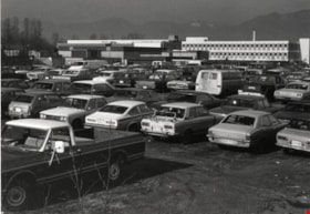
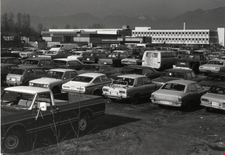
- Photograph shows vehicles in the BCIT parking lot off Wayburne Drive with the BCIT complex in the background.
- Repository
- City of Burnaby Archives
- Date
- February 7, 1977
- Collection/Fonds
- Burnaby Public Library Contemporary Visual Archive Project
- Physical Description
- 1 photograph : b&w ; 11 x 16 cm mounted on cardboard
- Description Level
- Item
- Record No.
- 556-371
- Access Restriction
- No restrictions
- Reproduction Restriction
- Reproduce for fair dealing purposes only
- Accession Number
- 2013-13
- Scope and Content
- Photograph shows vehicles in the BCIT parking lot off Wayburne Drive with the BCIT complex in the background.
- Media Type
- Photograph
- Notes
- Scope note taken directly from BPL photograph description.
- 1 b&w copy negative : 10 x 12.5 cm accompanying
- Photographers identified by surnames only: Carr and Vardeman
- Geographic Access
- Willingdon Avenue
- Wayburne Drive
- Street Address
- 3700 Willingdon Avenue
- Planning Study Area
- Douglas-Gilpin Area
Images
Big O Tire Store
https://search.heritageburnaby.ca/link/archivedescription79259
- Repository
- City of Burnaby Archives
- Date
- October 16, 1976
- Collection/Fonds
- Burnaby Public Library Contemporary Visual Archive Project
- Description Level
- Item
- Physical Description
- 1 photograph : b&w ; 11 x 16 cm mounted on cardboard
- Scope and Content
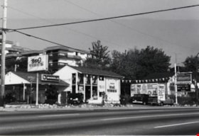
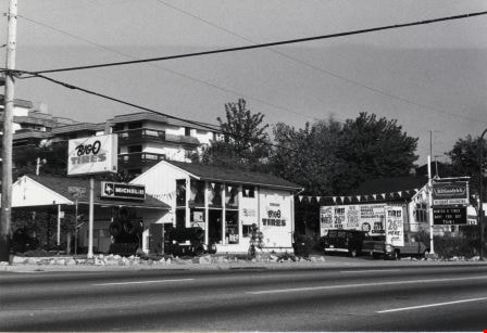
- Photograph shows the Big O Tire Store at 5511 Hastings Street near Howard Avenue.
- Repository
- City of Burnaby Archives
- Date
- October 16, 1976
- Collection/Fonds
- Burnaby Public Library Contemporary Visual Archive Project
- Physical Description
- 1 photograph : b&w ; 11 x 16 cm mounted on cardboard
- Description Level
- Item
- Record No.
- 556-225
- Access Restriction
- No restrictions
- Reproduction Restriction
- Reproduce for fair dealing purposes only
- Accession Number
- 2013-13
- Scope and Content
- Photograph shows the Big O Tire Store at 5511 Hastings Street near Howard Avenue.
- Names
- Big O Tire Store
- Media Type
- Photograph
- Notes
- Scope note taken directly from BPL photograph description.
- 1 b&w copy negative : 10 x 12.5 cm accompanying
- Photographers identified by surnames only: Carr and Vardeman
- Geographic Access
- Hastings Street
- Street Address
- 5511 Hastings Street
- Historic Neighbourhood
- Capitol Hill (Historic Neighbourhood)
- Planning Study Area
- Capitol Hill Area
Images

Billboards at Hastings and Boundary
https://search.heritageburnaby.ca/link/archivedescription79163
- Repository
- City of Burnaby Archives
- Date
- November 1, 1976
- Collection/Fonds
- Burnaby Public Library Contemporary Visual Archive Project
- Description Level
- Item
- Physical Description
- 1 photograph : b&w ; 11 x 16 cm mounted on cardboard
- Scope and Content
- Photograph shows men working on billboards above Moffat's Furniture at the corner of Hastings Street and Boundary Road.
- Repository
- City of Burnaby Archives
- Date
- November 1, 1976
- Collection/Fonds
- Burnaby Public Library Contemporary Visual Archive Project
- Physical Description
- 1 photograph : b&w ; 11 x 16 cm mounted on cardboard
- Description Level
- Item
- Record No.
- 556-182
- Access Restriction
- No restrictions
- Reproduction Restriction
- Reproduce for fair dealing purposes only
- Accession Number
- 2013-13
- Scope and Content
- Photograph shows men working on billboards above Moffat's Furniture at the corner of Hastings Street and Boundary Road.
- Names
- Moffat's Furniture
- Media Type
- Photograph
- Notes
- Scope note taken directly from BPL photograph description.
- 1 b&w copy negative : 10 x 12.5 cm accompanying
- Photographers identified by surnames only: Carr and Vardeman
- Geographic Access
- Hastings Street
- Boundary Road
- Historic Neighbourhood
- Vancouver Heights (Historic Neighbourhood)
- Planning Study Area
- Willingdon Heights Area
Images


Burnaby Fish and Game Club Range
https://search.heritageburnaby.ca/link/archivedescription79719
- Repository
- City of Burnaby Archives
- Date
- September 12, 1976
- Collection/Fonds
- Burnaby Public Library Contemporary Visual Archive Project
- Description Level
- Item
- Physical Description
- 1 photograph : b&w ; 11 x 16 cm mounted on cardboard
- Scope and Content
- Photograph shows cars parked outside the Burnaby Fish and Game Club Rifle Range at 8242 Barnet Road.
- Repository
- City of Burnaby Archives
- Date
- September 12, 1976
- Collection/Fonds
- Burnaby Public Library Contemporary Visual Archive Project
- Physical Description
- 1 photograph : b&w ; 11 x 16 cm mounted on cardboard
- Description Level
- Item
- Record No.
- 556-400
- Access Restriction
- No restrictions
- Reproduction Restriction
- Reproduce for fair dealing purposes only
- Accession Number
- 2013-13
- Scope and Content
- Photograph shows cars parked outside the Burnaby Fish and Game Club Rifle Range at 8242 Barnet Road.
- Media Type
- Photograph
- Notes
- Scope note taken directly from BPL photograph description.
- 1 b&w copy negative : 10 x 12.5 cm accompanying
- Photographers identified by surnames only: Carr and Vardeman
- Geographic Access
- Barnet Road
- Street Address
- 8242 Barnet Road
- Historic Neighbourhood
- Barnet (Historic Neighbourhood)
- Planning Study Area
- Burnaby Mountain Area
Images

Burnaby Mountain Autobody and Dedemus (Lloyd) Electric Ltd.
https://search.heritageburnaby.ca/link/archivedescription79209
- Repository
- City of Burnaby Archives
- Date
- September 11, 1976
- Collection/Fonds
- Burnaby Public Library Contemporary Visual Archive Project
- Description Level
- Item
- Physical Description
- 1 photograph : b&w ; 11 x 16 cm mounted on cardboard
- Scope and Content
- Photograph shows Burnaby Mountain Autobody and Dedemus (Lloyd) Electric Ltd. at 6861 Hastings Street with Burnaby Automotive in the rear.
- Repository
- City of Burnaby Archives
- Date
- September 11, 1976
- Collection/Fonds
- Burnaby Public Library Contemporary Visual Archive Project
- Physical Description
- 1 photograph : b&w ; 11 x 16 cm mounted on cardboard
- Description Level
- Item
- Record No.
- 556-208
- Access Restriction
- No restrictions
- Reproduction Restriction
- Reproduce for fair dealing purposes only
- Accession Number
- 2013-13
- Scope and Content
- Photograph shows Burnaby Mountain Autobody and Dedemus (Lloyd) Electric Ltd. at 6861 Hastings Street with Burnaby Automotive in the rear.
- Media Type
- Photograph
- Notes
- Scope note taken directly from BPL photograph description.
- 1 b&w copy negative : 10 x 12.5 cm accompanying
- Photographers identified by surnames only: Carr and Vardeman
- Geographic Access
- Hastings Street
- Street Address
- 6861 Hastings Street
- Historic Neighbourhood
- Lochdale (Historic Neighbourhood)
- Planning Study Area
- Westridge Area
Images

Burnaby North Baptist Church
https://search.heritageburnaby.ca/link/archivedescription79055
- Repository
- City of Burnaby Archives
- Date
- September 12, 1976
- Collection/Fonds
- Burnaby Public Library Contemporary Visual Archive Project
- Description Level
- Item
- Physical Description
- 1 photograph : b&w ; 11 x 16 cm mounted on cardboard
- Scope and Content
- Photograph shows the Burnaby North Baptist Church at 3977 Albert Street on the corner of MacDonald Avenue.
- Repository
- City of Burnaby Archives
- Date
- September 12, 1976
- Collection/Fonds
- Burnaby Public Library Contemporary Visual Archive Project
- Physical Description
- 1 photograph : b&w ; 11 x 16 cm mounted on cardboard
- Description Level
- Item
- Record No.
- 556-121
- Access Restriction
- No restrictions
- Reproduction Restriction
- Reproduce for fair dealing purposes only
- Accession Number
- 2013-13
- Scope and Content
- Photograph shows the Burnaby North Baptist Church at 3977 Albert Street on the corner of MacDonald Avenue.
- Subjects
- Buildings - Religious - Churches
- Media Type
- Photograph
- Notes
- Scope note taken directly from BPL photograph description.
- 1 b&w copy negative : 10 x 12.5 cm accompanying
- Photographers identified by surnames only: Carr and Vardeman
- Geographic Access
- Albert Street
- Street Address
- 3977 Albert Street
- Historic Neighbourhood
- Vancouver Heights (Historic Neighbourhood)
- Planning Study Area
- Burnaby Heights Area
Images


Capitol Hill Pentecostal Tabernacle
https://search.heritageburnaby.ca/link/archivedescription79065
- Repository
- City of Burnaby Archives
- Date
- October 16, 1976
- Collection/Fonds
- Burnaby Public Library Contemporary Visual Archive Project
- Description Level
- Item
- Physical Description
- 1 photograph : b&w ; 11 x 16 cm mounted on cardboard
- Scope and Content
- Photograph shows the Capitol Hill Pentecostal Tabernacle located on the corner of Hastings Street and Springer Avenue, with apartment buildings in the background.
- Repository
- City of Burnaby Archives
- Date
- October 16, 1976
- Collection/Fonds
- Burnaby Public Library Contemporary Visual Archive Project
- Physical Description
- 1 photograph : b&w ; 11 x 16 cm mounted on cardboard
- Description Level
- Item
- Record No.
- 556-128
- Access Restriction
- No restrictions
- Reproduction Restriction
- Reproduce for fair dealing purposes only
- Accession Number
- 2013-13
- Scope and Content
- Photograph shows the Capitol Hill Pentecostal Tabernacle located on the corner of Hastings Street and Springer Avenue, with apartment buildings in the background.
- Subjects
- Buildings - Religious - Churches
- Media Type
- Photograph
- Notes
- Scope note taken directly from BPL photograph description.
- 1 b&w copy negative : 10 x 12.5 cm accompanying
- Photographers identified by surnames only: Carr and Vardeman
- Geographic Access
- Hastings Street
- Street Address
- 5209 Hastings Street
- Historic Neighbourhood
- Capitol Hill (Historic Neighbourhood)
- Planning Study Area
- Capitol Hill Area
Images


Celebrations of Life & Love: Ceramic Works of Thomas Kakinuma
https://search.heritageburnaby.ca/link/museumdescription17536
- Repository
- Burnaby Village Museum
- Date
- 12 Oct. 2021
- Collection/Fonds
- Burnaby Village Museum fonds
- Description Level
- Item
- Physical Description
- 1 video recording (mp4) (66 min., 9 sec.) : digital, col., sd., stereo ; 29 fps
- Scope and Content
- Item consists of a video recording of a live Zoom webinar. The webinar was presented on the Zoom webinar platform and also presented live on the Burnaby Village Museum Facebook page on October 12, 2021. The webinar was hosted by Burnaby Village Museum Community Engagement Coordinator, Christina Fr…
- Repository
- Burnaby Village Museum
- Collection/Fonds
- Burnaby Village Museum fonds
- Description Level
- Item
- Physical Description
- 1 video recording (mp4) (66 min., 9 sec.) : digital, col., sd., stereo ; 29 fps
- Material Details
- Presenter: Debra Sloan
- Host: Christina Froschauer
- Date of Presentation: October 12, 2021
- Total Number of tracks: 1
- Total Length of all tracks: 66 min., 9 sec.
- Recording Device: Zoom video communication and Facebook platforms
- Recording Note: Film was edited from it's original recorded version (71 min., 36 sec.) to edited version (66 min., 9 sec.) for public viewing on Heritage Burnaby.
- Scope and Content
- Item consists of a video recording of a live Zoom webinar. The webinar was presented on the Zoom webinar platform and also presented live on the Burnaby Village Museum Facebook page on October 12, 2021. The webinar was hosted by Burnaby Village Museum Community Engagement Coordinator, Christina Froschauer and presented by Debra Sloan. The webinar is titled "Celebrations of Life & Love: Ceramic Works of Thomas Kakinuma". In this webinar, Debra Sloan talks about the life and work of UBC professor and Burnaby resident, Thomas Kakinuma who was a celebrated award winning and internationally recognized ceramicist known for his intriguing mid-century pieces, charismatic animal sculptures and return to Japanese aesthetics through his post-war practice. Debra supports her presentation with archival, personal and exhibit photographs showcasing Thomas Kakinuma's life and works. During breaks in the presentation, Christina and Debra take questions from webinar participants on zoom as well as viewers from the live recording on Burnaby Village Museum's Facebook page. Resource links shared during the presentation include: Debra Sloan www.debrasloan.com North-West Ceramics Foundation www.nwcf.ca Potters Guild of BC www.bcpotters.com Fraser Valley Potters Guild www.fraservalleypottersguild.com Craft Council of British Columbia www.craftcouncilbc.ca Thomas Kakinuma’s work in collections: West Vancouver Art Museum Collection www.westvancouverartmuseum.ca/collections Museum of Anthropology – BC Ceramic Collection www.moa.ubc.ca/collections
- History
- Vancouverite, Debra Sloan gained an interest in ceramics early, in her teen years, and her passion for the practice has remained with her throughout her life. Her education in ceramics is a mix of self-taught informal learning, as well as formal learning, including studying at the Vancouver School of Art in the early 80s and later receiving a Bachelor of Fine Art from Emily Carr University in the early 2000s. Her work has been exhibited regionally, nationally, and internationally and she has participated in numerous artist residencies, and is the recipient of numerous awards and scholarships, with projects funded by British Columbia Arts Council and Canada Council for the Arts. Closer to home, Debra instructed sculpture classes at the Burnaby Shadbolt Center for the Arts, where she worked for over two decades. Over the years, Debra also took to researching, writing and publishing about the history of ceramics in British Columbia and has worked with colleagues to build a Registry of B.C. ceramicists. Recently, in 2017 and 2018, she was involved in the West Vancouver Museum’s retrospective exhibition of Thomas Kakinuma’s work, writing the catalogue, “The Ceramic Art of Thomas Kakinuma.”
- Subjects
- Persons - Japanese Canadians
- Accession Code
- BV021.31.2
- Access Restriction
- No restrictions
- Reproduction Restriction
- No known restrictions
- Date
- 12 Oct. 2021
- Media Type
- Moving Images
- Notes
- Title based on contents of video recording
- Historical biography of Debra Sloan is taken from recording of presentation
Images

Video
Celebrations of Life & Love: Ceramic Works of Thomas Kakinuma, 12 Oct. 2021
Celebrations of Life & Love: Ceramic Works of Thomas Kakinuma, 12 Oct. 2021
https://search.heritageburnaby.ca/media/hpo/_Data/_BVM_Moving_Images/2021_0031_0002_002.mp4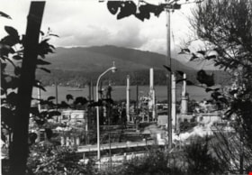
Chevron Oil Refinery
https://search.heritageburnaby.ca/link/archivedescription79435
- Repository
- City of Burnaby Archives
- Date
- September 5, 1976
- Collection/Fonds
- Burnaby Public Library Contemporary Visual Archive Project
- Description Level
- Item
- Physical Description
- 1 photograph : b&w ; 11 x 16 cm mounted on cardboard
- Scope and Content
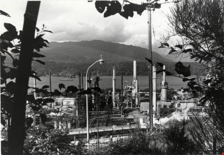
- Photograph shows an aerial view of the Chevron Oil Refinery at the north end of Willingdon Avenue with the North Shore in the background. The photo was taken from the top of Penzance Drive.
- Repository
- City of Burnaby Archives
- Date
- September 5, 1976
- Collection/Fonds
- Burnaby Public Library Contemporary Visual Archive Project
- Physical Description
- 1 photograph : b&w ; 11 x 16 cm mounted on cardboard
- Description Level
- Item
- Record No.
- 556-287
- Access Restriction
- No restrictions
- Reproduction Restriction
- Reproduce for fair dealing purposes only
- Accession Number
- 2013-13
- Scope and Content
- Photograph shows an aerial view of the Chevron Oil Refinery at the north end of Willingdon Avenue with the North Shore in the background. The photo was taken from the top of Penzance Drive.
- Names
- Chevron Corporation
- Media Type
- Photograph
- Notes
- Scope note taken directly from BPL photograph description.
- 1 b&w copy negative : 10 x 12.5 cm accompanying
- Photographers identified by surnames only: Carr and Vardeman
- Geographic Access
- Eton Street
- Street Address
- 4403 Eton Street
- Historic Neighbourhood
- Vancouver Heights (Historic Neighbourhood)
- Planning Study Area
- Burnaby Heights Area
Images
Chevron Oil Refinery
https://search.heritageburnaby.ca/link/archivedescription79436
- Repository
- City of Burnaby Archives
- Date
- September 12, 1976
- Collection/Fonds
- Burnaby Public Library Contemporary Visual Archive Project
- Description Level
- Item
- Physical Description
- 1 photograph : b&w ; 11 x 16 cm mounted on cardboard
- Scope and Content
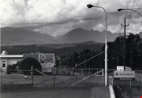
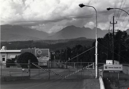
- Photograph shows the entrance gate to the Chevron Oil Refinery at the north end of Willingdon Avenue, with a view of the North Shore in the background.
- Repository
- City of Burnaby Archives
- Date
- September 12, 1976
- Collection/Fonds
- Burnaby Public Library Contemporary Visual Archive Project
- Physical Description
- 1 photograph : b&w ; 11 x 16 cm mounted on cardboard
- Description Level
- Item
- Record No.
- 556-288
- Access Restriction
- No restrictions
- Reproduction Restriction
- Reproduce for fair dealing purposes only
- Accession Number
- 2013-13
- Scope and Content
- Photograph shows the entrance gate to the Chevron Oil Refinery at the north end of Willingdon Avenue, with a view of the North Shore in the background.
- Names
- Chevron Corporation
- Media Type
- Photograph
- Notes
- Scope note taken directly from BPL photograph description.
- 1 b&w copy negative : 10 x 12.5 cm accompanying
- Photographers identified by surnames only: Carr and Vardeman
- Geographic Access
- Eton Street
- Street Address
- 4403 Eton Street
- Historic Neighbourhood
- Vancouver Heights (Historic Neighbourhood)
- Planning Study Area
- Burnaby Heights Area
Images

Closed Gas Station
https://search.heritageburnaby.ca/link/archivedescription79271
- Repository
- City of Burnaby Archives
- Date
- February 7, 1977
- Collection/Fonds
- Burnaby Public Library Contemporary Visual Archive Project
- Description Level
- Item
- Physical Description
- 1 photograph : b&w ; 11 x 16 cm mounted on cardboard
- Scope and Content
- Photograph shows a closed gas station on Kingsway near McKercher Avenue.
- Repository
- City of Burnaby Archives
- Date
- February 7, 1977
- Collection/Fonds
- Burnaby Public Library Contemporary Visual Archive Project
- Physical Description
- 1 photograph : b&w ; 11 x 16 cm mounted on cardboard
- Description Level
- Item
- Record No.
- 556-233
- Access Restriction
- No restrictions
- Reproduction Restriction
- Reproduce for fair dealing purposes only
- Accession Number
- 2013-13
- Scope and Content
- Photograph shows a closed gas station on Kingsway near McKercher Avenue.
- Media Type
- Photograph
- Notes
- Scope note taken directly from BPL photograph description.
- 1 b&w copy negative : 10 x 12.5 cm accompanying
- Photographers identified by surnames only: Carr and Vardeman
- Geographic Access
- McKercher Avenue
- Kingsway
- Historic Neighbourhood
- Central Park (Historic Neighbourhood)
- Planning Study Area
- Marlborough Area
Images


Corner of Buxton and Royal Oak
https://search.heritageburnaby.ca/link/archivedescription78895
- Repository
- City of Burnaby Archives
- Date
- February 7, 1977
- Collection/Fonds
- Burnaby Public Library Contemporary Visual Archive Project
- Description Level
- Item
- Physical Description
- 1 photograph : b&w ; 11 x 16 cm mounted on cardboard
- Scope and Content
- Photograph shows a house on the corner of Buxton Street and Royal Oak Avenue with a view of north Burnaby and the North Shore in the background.
- Repository
- City of Burnaby Archives
- Date
- February 7, 1977
- Collection/Fonds
- Burnaby Public Library Contemporary Visual Archive Project
- Physical Description
- 1 photograph : b&w ; 11 x 16 cm mounted on cardboard
- Description Level
- Item
- Record No.
- 556-020
- Access Restriction
- No restrictions
- Reproduction Restriction
- Reproduce for fair dealing purposes only
- Accession Number
- 2013-13
- Scope and Content
- Photograph shows a house on the corner of Buxton Street and Royal Oak Avenue with a view of north Burnaby and the North Shore in the background.
- Media Type
- Photograph
- Notes
- Scope note taken directly from BPL photograph description.
- 1 b&w copy negative : 10 x 12.5 cm accompanying
- Photographers identified by surnames only: Carr and Vardeman
- Geographic Access
- Buxton Street
- Royal Oak Avenue
- Historic Neighbourhood
- Central Park (Historic Neighbourhood)
- Planning Study Area
- Marlborough Area
Images

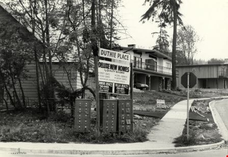
Corner of Duthie and Hewitt
https://search.heritageburnaby.ca/link/archivedescription78896
- Repository
- City of Burnaby Archives
- Date
- September 11, 1976
- Collection/Fonds
- Burnaby Public Library Contemporary Visual Archive Project
- Description Level
- Item
- Physical Description
- 1 photograph : b&w ; 11 x 16 cm mounted on cardboard
- Scope and Content
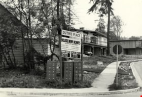
- Photograph shows a sign on the corner of Duthie Avenue and Hewitt Street advertising new homes for sale in the Duthie Place by Chivers Realty and Villa Realty, with a view of the homes in the background.
- Repository
- City of Burnaby Archives
- Date
- September 11, 1976
- Collection/Fonds
- Burnaby Public Library Contemporary Visual Archive Project
- Physical Description
- 1 photograph : b&w ; 11 x 16 cm mounted on cardboard
- Description Level
- Item
- Record No.
- 556-021
- Access Restriction
- No restrictions
- Reproduction Restriction
- Reproduce for fair dealing purposes only
- Accession Number
- 2013-13
- Scope and Content
- Photograph shows a sign on the corner of Duthie Avenue and Hewitt Street advertising new homes for sale in the Duthie Place by Chivers Realty and Villa Realty, with a view of the homes in the background.
- Media Type
- Photograph
- Notes
- Scope note taken directly from BPL photograph description.
- 5/29/2017 - Photograph Missing
- 1 b&w copy negative : 10 x 12.5 cm accompanying
- Photographers identified by surnames only: Carr and Vardeman
- Geographic Access
- Duthie Avenue
- Hewitt Street
- Historic Neighbourhood
- Lochdale (Historic Neighbourhood)
- Planning Study Area
- Lochdale Area
Images

Corner of McGill and Gilmore
https://search.heritageburnaby.ca/link/archivedescription78894
- Repository
- City of Burnaby Archives
- Date
- September 5, 1976
- Collection/Fonds
- Burnaby Public Library Contemporary Visual Archive Project
- Description Level
- Item
- Physical Description
- 1 photograph : b&w ; 11 x 16 cm mounted on cardboard
- Scope and Content
- Photograph shows view of houses and the North Shore from the corner of McGill Street and Gilmore Avenue.
- Repository
- City of Burnaby Archives
- Date
- September 5, 1976
- Collection/Fonds
- Burnaby Public Library Contemporary Visual Archive Project
- Physical Description
- 1 photograph : b&w ; 11 x 16 cm mounted on cardboard
- Description Level
- Item
- Record No.
- 556-019
- Access Restriction
- No restrictions
- Reproduction Restriction
- Reproduce for fair dealing purposes only
- Accession Number
- 2013-13
- Scope and Content
- Photograph shows view of houses and the North Shore from the corner of McGill Street and Gilmore Avenue.
- Subjects
- Aerial Photographs
- Media Type
- Photograph
- Notes
- Scope note taken directly from BPL photograph description.
- 1 b&w copy negative : 10 x 12.5 cm accompanying
- Photographers identified by surnames only: Carr and Vardeman
- Geographic Access
- McGill Street
- Gilmore Avenue
- Historic Neighbourhood
- Vancouver Heights (Historic Neighbourhood)
- Planning Study Area
- Burnaby Heights Area
Images

![Corsbie family home on Springer Avenue, [197-] thumbnail](/media/hpo/_Data/_BVM_Images/2020/2020_0031_0026_001.jpg?width=280)
Corsbie family home on Springer Avenue
https://search.heritageburnaby.ca/link/museumdescription20305
- Repository
- Burnaby Village Museum
- Date
- [197-]
- Collection/Fonds
- Joseph H.C. Corsbie fonds
- Description Level
- Item
- Physical Description
- 1 photograph : col. ; 8.5 x 8.5 cm
- Scope and Content
- Photograph of the family home of Joseph (Joe) H. Corsbie and Margaret Corsbie (nee Carr) located at 84 Springer Avenue (North). The Corsbie's lived in this house from 1952 until 1988 and moved to White Rock upon retirement. The front lawn and rooftops tops are covered with snow.
- Repository
- Burnaby Village Museum
- Collection/Fonds
- Joseph H.C. Corsbie fonds
- Description Level
- Item
- Physical Description
- 1 photograph : col. ; 8.5 x 8.5 cm
- Scope and Content
- Photograph of the family home of Joseph (Joe) H. Corsbie and Margaret Corsbie (nee Carr) located at 84 Springer Avenue (North). The Corsbie's lived in this house from 1952 until 1988 and moved to White Rock upon retirement. The front lawn and rooftops tops are covered with snow.
- Geographic Access
- Springer Avenue
- Springer Avenue North
- Street Address
- 84 Springer Avenue
- Accession Code
- BV020.31.26
- Access Restriction
- No restrictions
- Reproduction Restriction
- No known restrictions
- Date
- [197-]
- Media Type
- Photograph
- Scan Resolution
- 600
- Scan Date
- 19-09-2023
- Notes
- Title based on contents of photograph
Images
![Corsbie family home on Springer Avenue, [197-] thumbnail](/media/hpo/_Data/_BVM_Images/2020/2020_0031_0026_001.jpg)
![Corsbie family home on Springer Avenue, [197-] thumbnail](/media/hpo/_Data/_BVM_Images/2020/2020_0031_0027_001.jpg?width=280)
Corsbie family home on Springer Avenue
https://search.heritageburnaby.ca/link/museumdescription20306
- Repository
- Burnaby Village Museum
- Date
- [197-]
- Collection/Fonds
- Joseph H.C. Corsbie fonds
- Description Level
- Item
- Physical Description
- 1 photograph : col. ; 9 x 13 cm
- Scope and Content
- Photograph of the family home of Joseph (Joe) H. Corsbie and Margaret Corsbie (nee Carr) located at 84 Springer Avenue (North). The Corsbie's lived in this house from 1952 until 1988 and moved to White Rock upon retirement.
- Repository
- Burnaby Village Museum
- Collection/Fonds
- Joseph H.C. Corsbie fonds
- Description Level
- Item
- Physical Description
- 1 photograph : col. ; 9 x 13 cm
- Scope and Content
- Photograph of the family home of Joseph (Joe) H. Corsbie and Margaret Corsbie (nee Carr) located at 84 Springer Avenue (North). The Corsbie's lived in this house from 1952 until 1988 and moved to White Rock upon retirement.
- Subjects
- Buildings - Residential
- Geographic Access
- Springer Avenue
- Springer Avenue North
- Street Address
- 84 Springer Avenue
- Accession Code
- BV020.31.27
- Access Restriction
- No restrictions
- Reproduction Restriction
- No known restrictions
- Date
- [197-]
- Media Type
- Photograph
- Scan Resolution
- 600
- Scan Date
- 19-09-2023
- Notes
- Title based on contents of photograph
- Note on verso of photograph reads: "84N.Springer /N_Bby"
Images
![Corsbie family home on Springer Avenue, [197-] thumbnail](/media/hpo/_Data/_BVM_Images/2020/2020_0031_0027_001.jpg)
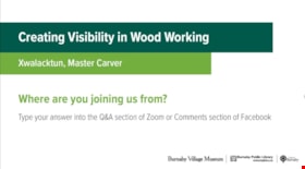
Creating Visibility in Wood Working
https://search.heritageburnaby.ca/link/museumdescription15667
- Repository
- Burnaby Village Museum
- Date
- 6 May 2021
- Collection/Fonds
- Burnaby Village Museum fonds
- Description Level
- Item
- Physical Description
- 1 video recording (mp4) (50 min., 03 sec.) : digital, col., sd., stereo ; 29 fps
- Scope and Content
- Item consists of a video recording of a live Zoom webinar hosted by Burnaby Village Museum curator, Jane Lemke. The webinar is titled "Creating Visibility in Wood Working" and is presented by Xwalacktun, OBC, Master Carver of the Sḵwx̱wú7mesh Nation. The Zoom webinar is the fourth in a series of si…
- Repository
- Burnaby Village Museum
- Collection/Fonds
- Burnaby Village Museum fonds
- Description Level
- Item
- Physical Description
- 1 video recording (mp4) (50 min., 03 sec.) : digital, col., sd., stereo ; 29 fps
- Material Details
- Presenter: Xwalacktun
- Host: Jane Lemke
- Date of Presentation: Thursday, May 6, 7:00 pm - 8:00 pm
- Total Number of tracks: 1
- Total Length of all tracks: 50 min., 03 sec.
- Recording Device: Zoom video communication platform
- Recording Note: Film was edited from it's original recorded version (66 min., 53 sec.) to edited version (50 min., 03 sec.) for public viewing on Heritage Burnaby.
- Scope and Content
- Item consists of a video recording of a live Zoom webinar hosted by Burnaby Village Museum curator, Jane Lemke. The webinar is titled "Creating Visibility in Wood Working" and is presented by Xwalacktun, OBC, Master Carver of the Sḵwx̱wú7mesh Nation. The Zoom webinar is the fourth in a series of six "Neighbourhood Speaker series" webinars exploring a range of topics shared by Indigenous speakers and knowledge keepers that were presented and made available to the public between April 27 and May 12, 2021. The live webinar was also made available on the Burnaby Village Museum's facebook page. Community members were invited to participate by bringing questions during the interactive online sessions. In this webinar, viewers join Xwalacktun as he tours his studio, sharing the tools and processes of carving. Xwalacktun shares photographs detailing the long process of turning a twelve foot-tall tree into a house post for his recently completed installation in the Diamond Family Courtyard of Vancouver General Hospital. At the beginning of the presentation, Xwalacktun shares a welcome song from the late Chief Cie Baker. Following the presentation, Xwalacktun takes questions from the audience that are moderated by the host, Jane Lemke.
- History
- Xwalacktun (born Rick Harry) is a Sḵwx̱wú7mesh Nation artist whose works are recognized internationally. He was given his name by his father, a Hereditary Chief from the Seymour Creek area. From 1978 to 1982, Xwalacktun attended Emily Carr University of Art and Design in Vancouver, BC, and graduated with a degree in sculpture. Xwalacktun is a recipient of the Queen Elizabeth II Diamond Jubilee Medal and the Order of British Columbia (O.B.C.) for his many contributions to various communities. Xwalacktun is an accomplished artist in wood, paper, stone, glass and metals and his work can be seen around the Lower Mainland region. Xwalacktun's biography can also be found on his website: www.xwalacktun.ca
- Subjects
- Indigenous peoples - British Columbia
- Indigenous peoples - British Columbia - Art
- Indigenous wood-carving - Totem poles
- Indigenous peoples - British Columbia - Rites and ceremonies
- Indigenous peoples - Implements
- Accession Code
- BV021.17.4
- Access Restriction
- No restrictions
- Reproduction Restriction
- No known restrictions
- Date
- 6 May 2021
- Media Type
- Moving Images
- Notes
- Title based on content of video recording The following link was shared at the end of the presentation: Xwalacktun’s website: https://www.xwalacktun.ca/
Images
Video
Creating Visibility in Wood Working, 6 May 2021
Creating Visibility in Wood Working, 6 May 2021
https://search.heritageburnaby.ca/media/hpo/_Data/_BVM_Moving_Images/2021_0017_0004_002.mp4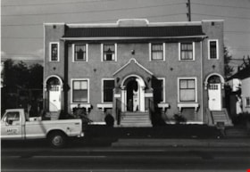
Doctors' Office
https://search.heritageburnaby.ca/link/archivedescription79511
- Repository
- City of Burnaby Archives
- Date
- November 1, 1976
- Collection/Fonds
- Burnaby Public Library Contemporary Visual Archive Project
- Description Level
- Item
- Physical Description
- 1 photograph : b&w ; 11 x 16 cm mounted on cardboard
- Scope and Content
- Photograph shows a doctors' office at 3915 Hastings Street.
- Repository
- City of Burnaby Archives
- Date
- November 1, 1976
- Collection/Fonds
- Burnaby Public Library Contemporary Visual Archive Project
- Physical Description
- 1 photograph : b&w ; 11 x 16 cm mounted on cardboard
- Description Level
- Item
- Record No.
- 556-338
- Access Restriction
- No restrictions
- Reproduction Restriction
- Reproduce for fair dealing purposes only
- Accession Number
- 2013-13
- Scope and Content
- Photograph shows a doctors' office at 3915 Hastings Street.
- Media Type
- Photograph
- Notes
- Scope note taken directly from BPL photograph description.
- 1 b&w copy negative : 10 x 12.5 cm accompanying
- Photographers identified by surnames only: Carr and Vardeman
- Geographic Access
- Hastings Street
- Street Address
- 3915 Hastings Street
- Historic Neighbourhood
- Vancouver Heights (Historic Neighbourhood)
- Planning Study Area
- Burnaby Heights Area
Images


Dundas Market
https://search.heritageburnaby.ca/link/archivedescription79083
- Repository
- City of Burnaby Archives
- Date
- September 11, 1976
- Collection/Fonds
- Burnaby Public Library Contemporary Visual Archive Project
- Description Level
- Item
- Physical Description
- 1 photograph : b&w ; 11 x 16 cm mounted on cardboard
- Scope and Content
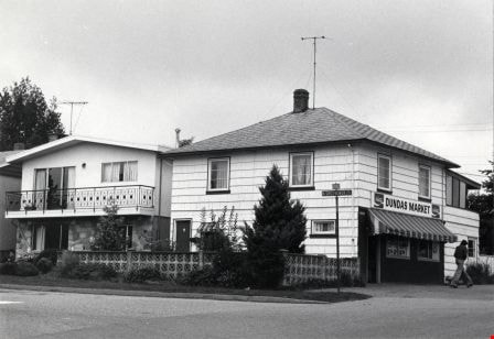
- Photograph shows Dundas Market at 5489 Dundas Street near Grosvenor Avenue.
- Repository
- City of Burnaby Archives
- Date
- September 11, 1976
- Collection/Fonds
- Burnaby Public Library Contemporary Visual Archive Project
- Physical Description
- 1 photograph : b&w ; 11 x 16 cm mounted on cardboard
- Description Level
- Item
- Record No.
- 556-142
- Access Restriction
- No restrictions
- Reproduction Restriction
- Reproduce for fair dealing purposes only
- Accession Number
- 2013-13
- Scope and Content
- Photograph shows Dundas Market at 5489 Dundas Street near Grosvenor Avenue.
- Names
- Dundas Market
- Media Type
- Photograph
- Notes
- Scope note taken directly from BPL photograph description.
- 1 b&w copy negative : 10 x 12.5 cm accompanying
- Photographers identified by surnames only: Carr and Vardeman
- Geographic Access
- Dundas Street
- Grosvenor Avenue
- Street Address
- 5489 Dundas Street
- Historic Neighbourhood
- Capitol Hill (Historic Neighbourhood)
- Planning Study Area
- Capitol Hill Area
Images