Narrow Results By
Decade
- 2020s 40
- 2010s 25
- 2000s 145
- 1990s 157
- 1980s 145
- 1970s 549
- 1960s 251
- 1950s 254
- 1940s 187
- 1930s 166
- 1920s 318
- 1910s 142
- 1900s
- 1890s 27
- 1880s 10
- 1870s 5
- 1860s 6
- 1850s 3
- 1840s 1
- 1830s 1
- 1820s 1
- 1810s 2
- 1800s 2
- 1790s 2
- 1780s 2
- 1770s 2
- 1760s 2
- 1750s 2
- 1740s 2
- 1730s 2
- 1720s 2
- 1710s 2
- 1700s 2
- 1690s 2
- 1680s 2
- 1670s 1
- 1660s 1
- 1650s 1
- 1640s 1
- 1630s 1
- 1620s 1
- 1610s 1
- 1600s
- 1590s 1
- 1580s 1
- 1570s 1
- 1560s 1
- 1550s 1
- 1540s 1
- 1530s 1
- 1520s 2
- 1510s 1
- 1500s 1
- 1490s 1
- 1480s 1
Subject
- Agricultural Tools and Equipment 2
- Agriculture - Crops 4
- Agriculture - Farms 7
- Agriculture - Fruit and Berries 1
- Animals - Cats 1
- Animals - Dogs 2
- Animals - Horses 1
- Buildings - Heritage 1
- Buildings - Industrial - Sawmills 1
- Buildings - Public - Detention Facilities 1
- Buildings - Religious - Churches 1
- Buildings - Residences - Houses 1
Creator
- Burnaby Village Museum 1
- Cooksley, William Thomas 1
- Fong, Denise 1
- Garden, Hermon & Burwell 1
- Government of British Columbia - Department of Mines and Resources 1
- Government of Canada - Department of Mines - Geological Survey Branch 1
- Henry Whittaker 1
- Hill, Albert James 1
- Joesph Henry Bowman 1
- Shang Wu Yin Shu Guan 1
Person / Organization
- Bateman, Edwin W. 1
- Bateman, Marianne May 1
- Bingham, Alfred "Alf" 5
- Borstal School 1
- Bradbury, Dr. Bettina 4
- British Columbia Mills Timber and Trading Company 1
- Brown, Charles B. "Charlie" 1
- Burrell, Beverley "Bev" Lewarne 1
- Burton, John 4
- Buxton, Bernard Willian John 1
- Buxton, Leopold George 2
- Buxton, Mary Isabel 1

Alfred Bingham's writings - Track 1
https://search.heritageburnaby.ca/link/oralhistory251
- Repository
- City of Burnaby Archives
- Date Range
- 1865-1919
- Length
- 0:10:18
- Summary
- This portion of the recording includes Alfred Bingham's essay entitled Stump Rangers, a listing of early settlers that includes addresses and short descriptions, essays on Confederation Park, land clearing and on Burnaby's first Council meeting.
- Repository
- City of Burnaby Archives
- Summary
- This portion of the recording includes Alfred Bingham's essay entitled Stump Rangers, a listing of early settlers that includes addresses and short descriptions, essays on Confederation Park, land clearing and on Burnaby's first Council meeting.
- Date Range
- 1865-1919
- Photo Info
- Alfred Bingham, April 20, 1947. Item no. 010-066
- Length
- 0:10:18
- Scope and Content
- Recording is of Alfred Bingham's writings, as read by Alfred Bingham. Major themes discussed are: Pioneers, early days in Burnaby and the Co-op Movement. To view "Narrow By" terms for each track expand this description and see "Notes".
- Biographical Notes
- Alfred "Alf" Bingham was born in England in 1892 and moved to Canada in 1912. His first job in Canada was laying track for the Grand Trunk Pacific Railway (GTPR) from Edmonton to McBride in 1912. His second was in Vancouver at the Rat Portage Mill on False Creek, working on the Resaw machine. He quit after one week due to poor working conditions. After taking part in the 1919 Winnipeg General Strike as a delegate of the Retail and Mailorder Union (A.F.L.) on the Winnipeg Trades and Labour Council, Alfred moved to Burnaby where he and fellow Burnaby residents Aungus McLean and Percy Little worked ten hour days to build a Shingle Mill on the edge of Burnaby Lake for Simpson & Giberson. George Green, carpenter and millwright (author of “The History of Burnaby”) also helped in the construction of the mill. Alfred built his own home from lumber cut from the mill in the Lochdale area on Sherlock Street between Curtis Street and Kitchener Street. On April 10, 1920 Alfred married Mary Jane “Ada” Reynolds. Alfred and Ada often took in foster children during their marriage. Due to her nursing experience, Ada was often called upon to deliver babies in the Burnaby area. Alfred and Ada Bingham were instrumental members of the Army of the Common Good, collecting vegetables and grains from growers in the area and even producing over 125 tons of vegetables from its own gardens to feed children and youth suffering from the lack of resources during the Depression years. The army was in operation for ten years and during that time the members organised the Credit Union movement of British Columbia and drew up the Credit Union act thorough the Vancouver Co-operative Council. They also started Co-Op stores and the Co-Op Wholesale Society. Alfred was also Secretary of the Burnaby Housing committee and in 1946 he became the Secretary of the North Burnaby Labour Progressive Party (LPP). Mary Jane “Ada” (Reynolds) Bingham died on August 9, 1969. Her husband Alfred died on April 29, 1979.
- Total Tracks
- 12
- Total Length
- 1:38:06
- Interviewee Name
- Bingham, Alfred "Alf"
- Collection/Fonds
- Burnaby Historical Society fonds
- Subseries
- Oral history subseries
- Transcript Available
- MSS142-001 contains transcripts for each of the short stories
- Media Type
- Sound Recording
- Web Notes
- Interview was digitized in 2010 allowing it to be accessible on Heritage Burnaby. The digitization project was initiated by the Community Heritage Commission with support from City of Burnaby Council and the BC History Digitization Program of the Irving K. Barber Learning Centre, University of British Columbia. It was recognized by the Heritage Society of BC with an award in 2012.
Images

Audio Tracks
Track one of recording of Alfred Bingham's writings
Track one of recording of Alfred Bingham's writings
https://search.heritageburnaby.ca/media/hpo/_Data/_Archives_Oral_Histories/_Unrestricted/100-13-20-2/100-13-20-2_Track_1.mp3
Alfred Bingham's writings - Track 3
https://search.heritageburnaby.ca/link/oralhistory253
- Repository
- City of Burnaby Archives
- Date Range
- 1903-1940
- Length
- 0:09:46
- Summary
- This portion of the recording includes Alfred Bingham's descriptions of road construction in Burnaby, including the names of the settlers and logging companies involved in their construction. Alfred discusses the changes that took place during World War I, along with municipal Relief work that he t…
- Repository
- City of Burnaby Archives
- Summary
- This portion of the recording includes Alfred Bingham's descriptions of road construction in Burnaby, including the names of the settlers and logging companies involved in their construction. Alfred discusses the changes that took place during World War I, along with municipal Relief work that he took part in at Burnaby Mountain. Alfred also discusses early schools and mentions his wife, Ada Bingham.
- Date Range
- 1903-1940
- Photo Info
- Alfred Bingham, April 20, 1947. Item no. 010-066
- Length
- 0:09:46
- Planning Study Area
- Burnaby Mountain Area
- Scope and Content
- Recording is of Alfred Bingham's writings, as read by Alfred Bingham. Major themes discussed are: Pioneers, early days in Burnaby and the Co-op Movement. To view "Narrow By" terms for each track expand this description and see "Notes".
- Biographical Notes
- Alfred "Alf" Bingham was born in England in 1892 and moved to Canada in 1912. His first job in Canada was laying track for the Grand Trunk Pacific Railway (GTPR) from Edmonton to McBride in 1912. His second was in Vancouver at the Rat Portage Mill on False Creek, working on the Resaw machine. He quit after one week due to poor working conditions. After taking part in the 1919 Winnipeg General Strike as a delegate of the Retail and Mailorder Union (A.F.L.) on the Winnipeg Trades and Labour Council, Alfred moved to Burnaby where he and fellow Burnaby residents Aungus McLean and Percy Little worked ten hour days to build a Shingle Mill on the edge of Burnaby Lake for Simpson & Giberson. George Green, carpenter and millwright (author of “The History of Burnaby”) also helped in the construction of the mill. Alfred built his own home from lumber cut from the mill in the Lochdale area on Sherlock Street between Curtis Street and Kitchener Street. On April 10, 1920 Alfred married Mary Jane “Ada” Reynolds. Alfred and Ada often took in foster children during their marriage. Due to her nursing experience, Ada was often called upon to deliver babies in the Burnaby area. Alfred and Ada Bingham were instrumental members of the Army of the Common Good, collecting vegetables and grains from growers in the area and even producing over 125 tons of vegetables from its own gardens to feed children and youth suffering from the lack of resources during the Depression years. The army was in operation for ten years and during that time the members organised the Credit Union movement of British Columbia and drew up the Credit Union act thorough the Vancouver Co-operative Council. They also started Co-Op stores and the Co-Op Wholesale Society. Alfred was also Secretary of the Burnaby Housing committee and in 1946 he became the Secretary of the North Burnaby Labour Progressive Party (LPP). Mary Jane “Ada” (Reynolds) Bingham died on August 9, 1969. Her husband Alfred died on April 29, 1979.
- Total Tracks
- 12
- Total Length
- 1:38:06
- Interviewee Name
- Bingham, Alfred "Alf"
- Collection/Fonds
- Burnaby Historical Society fonds
- Subseries
- Oral history subseries
- Transcript Available
- MSS142-001 contains transcripts for each of the short stories
- Media Type
- Sound Recording
- Web Notes
- Interview was digitized in 2010 allowing it to be accessible on Heritage Burnaby. The digitization project was initiated by the Community Heritage Commission with support from City of Burnaby Council and the BC History Digitization Program of the Irving K. Barber Learning Centre, University of British Columbia. It was recognized by the Heritage Society of BC with an award in 2012.
Images
Audio Tracks
Track three of recording of Alfred Bingham's writings
Track three of recording of Alfred Bingham's writings
https://search.heritageburnaby.ca/media/hpo/_Data/_Archives_Oral_Histories/_Unrestricted/100-13-20-2/100-13-20-2_Track_3.mp3
Alfred Bingham's writings - Track 4
https://search.heritageburnaby.ca/link/oralhistory254
- Repository
- City of Burnaby Archives
- Date Range
- 1892-1955
- Length
- 0:07:38
- Summary
- This portion of the recording includes Alfred Bingham's reading of an essay written by Captain Thomas S. Guns describing the Lozells district, as well as quoting single sentences of various other writers on the topic of Deer Lake and the Burnaby Lake District. Alfred mentions the first schools of B…
- Repository
- City of Burnaby Archives
- Summary
- This portion of the recording includes Alfred Bingham's reading of an essay written by Captain Thomas S. Guns describing the Lozells district, as well as quoting single sentences of various other writers on the topic of Deer Lake and the Burnaby Lake District. Alfred mentions the first schools of Burnaby Lake and the "pleasure walk" along Douglas Road, from Vancouver to New Westminster.
- Date Range
- 1892-1955
- Photo Info
- Alfred Bingham, April 20, 1947. Item no. 010-066
- Length
- 0:07:38
- Historic Neighbourhood
- Lozells (Historic Neighbourhood)
- Burnaby Lake (Historic Neighbourhood)
- Scope and Content
- Recording is of Alfred Bingham's writings, as read by Alfred Bingham. Major themes discussed are: Pioneers, early days in Burnaby and the Co-op Movement. To view "Narrow By" terms for each track expand this description and see "Notes".
- Biographical Notes
- Alfred "Alf" Bingham was born in England in 1892 and moved to Canada in 1912. His first job in Canada was laying track for the Grand Trunk Pacific Railway (GTPR) from Edmonton to McBride in 1912. His second was in Vancouver at the Rat Portage Mill on False Creek, working on the Resaw machine. He quit after one week due to poor working conditions. After taking part in the 1919 Winnipeg General Strike as a delegate of the Retail and Mailorder Union (A.F.L.) on the Winnipeg Trades and Labour Council, Alfred moved to Burnaby where he and fellow Burnaby residents Aungus McLean and Percy Little worked ten hour days to build a Shingle Mill on the edge of Burnaby Lake for Simpson & Giberson. George Green, carpenter and millwright (author of “The History of Burnaby”) also helped in the construction of the mill. Alfred built his own home from lumber cut from the mill in the Lochdale area on Sherlock Street between Curtis Street and Kitchener Street. On April 10, 1920 Alfred married Mary Jane “Ada” Reynolds. Alfred and Ada often took in foster children during their marriage. Due to her nursing experience, Ada was often called upon to deliver babies in the Burnaby area. Alfred and Ada Bingham were instrumental members of the Army of the Common Good, collecting vegetables and grains from growers in the area and even producing over 125 tons of vegetables from its own gardens to feed children and youth suffering from the lack of resources during the Depression years. The army was in operation for ten years and during that time the members organised the Credit Union movement of British Columbia and drew up the Credit Union act thorough the Vancouver Co-operative Council. They also started Co-Op stores and the Co-Op Wholesale Society. Alfred was also Secretary of the Burnaby Housing committee and in 1946 he became the Secretary of the North Burnaby Labour Progressive Party (LPP). Mary Jane “Ada” (Reynolds) Bingham died on August 9, 1969. Her husband Alfred died on April 29, 1979.
- Total Tracks
- 12
- Total Length
- 1:38:06
- Interviewee Name
- Bingham, Alfred "Alf"
- Collection/Fonds
- Burnaby Historical Society fonds
- Subseries
- Oral history subseries
- Transcript Available
- MSS142-001 contains transcripts for each of the short stories
- Media Type
- Sound Recording
- Web Notes
- Interview was digitized in 2010 allowing it to be accessible on Heritage Burnaby. The digitization project was initiated by the Community Heritage Commission with support from City of Burnaby Council and the BC History Digitization Program of the Irving K. Barber Learning Centre, University of British Columbia. It was recognized by the Heritage Society of BC with an award in 2012.
Images
Audio Tracks
Track four of recording of Alfred Bingham's writings
Track four of recording of Alfred Bingham's writings
https://search.heritageburnaby.ca/media/hpo/_Data/_Archives_Oral_Histories/_Unrestricted/100-13-20-2/100-13-20-2_Track_4.mp3
Alfred Bingham's writings - Track 8
https://search.heritageburnaby.ca/link/oralhistory258
- Repository
- City of Burnaby Archives
- Date Range
- 1892-1963
- Length
- 0:07:05
- Summary
- This portion of the recording includes Alfred Bingham's continuation of reading his series of short stories. He reads; "THE RUM RUNNERS AND BOOTLEG WHISKY IN BURNABY" and "BURNABY. NORTH. SOUTH. EAST? AND WEST 1892---1943" both written in 1963.
- Repository
- City of Burnaby Archives
- Summary
- This portion of the recording includes Alfred Bingham's continuation of reading his series of short stories. He reads; "THE RUM RUNNERS AND BOOTLEG WHISKY IN BURNABY" and "BURNABY. NORTH. SOUTH. EAST? AND WEST 1892---1943" both written in 1963.
- Date Range
- 1892-1963
- Photo Info
- Alfred Bingham, April 20, 1947. Item no. 010-066
- Length
- 0:07:05
- Names
- Hawthorn, Mary
- Scope and Content
- Recording is of Alfred Bingham's writings, as read by Alfred Bingham. Major themes discussed are: Pioneers, early days in Burnaby and the Co-op Movement. To view "Narrow By" terms for each track expand this description and see "Notes".
- Biographical Notes
- Alfred "Alf" Bingham was born in England in 1892 and moved to Canada in 1912. His first job in Canada was laying track for the Grand Trunk Pacific Railway (GTPR) from Edmonton to McBride in 1912. His second was in Vancouver at the Rat Portage Mill on False Creek, working on the Resaw machine. He quit after one week due to poor working conditions. After taking part in the 1919 Winnipeg General Strike as a delegate of the Retail and Mailorder Union (A.F.L.) on the Winnipeg Trades and Labour Council, Alfred moved to Burnaby where he and fellow Burnaby residents Aungus McLean and Percy Little worked ten hour days to build a Shingle Mill on the edge of Burnaby Lake for Simpson & Giberson. George Green, carpenter and millwright (author of “The History of Burnaby”) also helped in the construction of the mill. Alfred built his own home from lumber cut from the mill in the Lochdale area on Sherlock Street between Curtis Street and Kitchener Street. On April 10, 1920 Alfred married Mary Jane “Ada” Reynolds. Alfred and Ada often took in foster children during their marriage. Due to her nursing experience, Ada was often called upon to deliver babies in the Burnaby area. Alfred and Ada Bingham were instrumental members of the Army of the Common Good, collecting vegetables and grains from growers in the area and even producing over 125 tons of vegetables from its own gardens to feed children and youth suffering from the lack of resources during the Depression years. The army was in operation for ten years and during that time the members organised the Credit Union movement of British Columbia and drew up the Credit Union act thorough the Vancouver Co-operative Council. They also started Co-Op stores and the Co-Op Wholesale Society. Alfred was also Secretary of the Burnaby Housing committee and in 1946 he became the Secretary of the North Burnaby Labour Progressive Party (LPP). Mary Jane “Ada” (Reynolds) Bingham died on August 9, 1969. Her husband Alfred died on April 29, 1979.
- Total Tracks
- 12
- Total Length
- 1:38:06
- Interviewee Name
- Bingham, Alfred "Alf"
- Collection/Fonds
- Burnaby Historical Society fonds
- Subseries
- Oral history subseries
- Transcript Available
- MSS142-001 contains transcripts for each of the short stories
- Media Type
- Sound Recording
- Web Notes
- Interview was digitized in 2010 allowing it to be accessible on Heritage Burnaby. The digitization project was initiated by the Community Heritage Commission with support from City of Burnaby Council and the BC History Digitization Program of the Irving K. Barber Learning Centre, University of British Columbia. It was recognized by the Heritage Society of BC with an award in 2012.
Images
Audio Tracks
Track eight of recording of Alfred Bingham's writings
Track eight of recording of Alfred Bingham's writings
https://search.heritageburnaby.ca/media/hpo/_Data/_Archives_Oral_Histories/_Unrestricted/100-13-20-2/100-13-20-2_Track_8.mp3
Angus & Margaret MacDonald House
https://search.heritageburnaby.ca/link/landmark495
- Repository
- Burnaby Heritage Planning
- Description
- Set on a large corner lot at North Esmond Avenue and Oxford Street, the Angus & Margaret MacDonald House is a prominent, two and one-half storey Queen Anne Revival-style residence. The high hipped roof has open projecting gables. The house is a landmark within the Vancouver Heights neighbourhood of…
- Associated Dates
- 1909
- Formal Recognition
- Heritage Designation, Community Heritage Register
- Street View URL
- Google Maps Street View
- Repository
- Burnaby Heritage Planning
- Geographic Access
- Oxford Street
- Associated Dates
- 1909
- Formal Recognition
- Heritage Designation, Community Heritage Register
- Enactment Type
- Bylaw No. 12174
- Enactment Date
- 11/12/2006
- Description
- Set on a large corner lot at North Esmond Avenue and Oxford Street, the Angus & Margaret MacDonald House is a prominent, two and one-half storey Queen Anne Revival-style residence. The high hipped roof has open projecting gables. The house is a landmark within the Vancouver Heights neighbourhood of North Burnaby, on a high point of land overlooking Burrard Inlet and the North Shore Mountains.
- Heritage Value
- The MacDonald House is valued as one of Burnaby’s most elaborate examples of the Queen Anne Revival style. The house retains many of its original features, including a prominent front corner turret wrapped by a clamshell verandah. The eclectic and transitional nature of Edwardian-era architecture is demonstrated by the late persistence of these Queen Anne Revival details, combined with the use of newly-popular classical revival elements such as Ionic columns. The interior retains a number of original architectural elements, and the early garage at the rear originally housed Angus MacDonald’s Cadillac, one of the first known automobiles owned by a Burnaby resident. Constructed in 1909, this house was built for Angus MacDonald (1857-1943) and his wife, Margaret Isabella Thompson MacDonald (1862-1939). Angus MacDonald, an electrical contractor, relocated from Nova Scotia to Vancouver in 1891 and served on Vancouver Council from 1904-08. The MacDonald family moved to Burnaby upon his retirement from the B.C. Electric Railway Company, and he then served the North Burnaby Ward as a councillor from 1911-1916 and again in 1921. MacDonald Street in Burnaby was named in his honour. The MacDonald House has additional significance as one of the surviving landmark residences, built between 1909 and 1914, during the first development of Vancouver Heights. In 1909, C.J. Peter and his employer, G.F. and J. Galt Limited, initiated the development of this North Burnaby neighbourhood, promoting it as one of the most picturesque districts in the region and an alternative to the CPR’s prestigious Shaughnessy Heights development in Vancouver. Buyers were obligated to build houses worth $3,500 at a time when the average house price was $1,000. Reputed to be the second house built in the subdivision, this house cost $7,000 to build.
- Defining Elements
- Key elements that define the heritage character of the MacDonald House include its: - prominent corner location in the Vancouver Heights neighbourhood, with views to Burrard Inlet and the North Shore Mountains - residential form, scale and massing as exemplified by its two and one-half storey height, full basement, compound plan, and high hipped roof with gabled projections at the front and side - wood-frame construction including wooden lapped siding, trim and mouldings - rubble-stone granite foundation - Queen Anne Revival details such as scroll-cut modillions, octagonal corner turret, wraparound, clamshell verandah with classical columns, and projecting square and semi-octagonal bays - external red-brick chimney with corbelled top - original windows including double-hung, 1-over-1 wooden sash windows in single and double assembly, and arched-top casement windows in the gable peaks - original interior features such as the main staircase, a panelled dining room with a fireplace and built-in cabinets, a living room with a parquet floor, and a rear den with an oak mantle and tiled hearth - associated early wood-frame garage at the rear of the property - landscape features such as mature coniferous and deciduous trees surrounding the property
- Historic Neighbourhood
- Vancouver Heights (Historic Neighbourhood)
- Planning Study Area
- Burnaby Heights Area
- Organization
- British Columbia Mills Timber and Trading Company
- Function
- Primary Historic--Single Dwelling
- Primary Current--Single Dwelling
- Community
- Vancouver Heights
- Cadastral Identifier
- P.I.D.011-999-462
- Boundaries
- The MacDonald House is comprised of a single residential lot located at 3814 Oxford Street, Burnaby.
- Area
- 566.71
- Contributing Resource
- Building
- Ownership
- Private
- Documentation
- City of Burnaby Planning and Building Department, Heritage Site Files
- Street Address
- 3814 Oxford Street
- Street View URL
- Google Maps Street View
Images


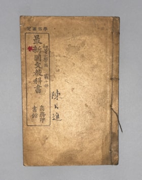
Authorized by the Education Ministry For Lower Division Primary School Use, Volume 10 New Chinese Language Textbook
https://search.heritageburnaby.ca/link/museumlibrary616
- Repository
- Burnaby Village Museum
- Collection
- Special Collection
- Material Type
- Book
- Accession Code
- BV985.360.10
- Author
- Shang Wu Yin Shu Guan
- Place of Publication
- Shanghai
- Publisher
- Commercial Press, Limited
- Publication Date
- 1906
- Physical Description
- 61 p. : ill (some col.), ports, maps ; 22 cm
- Subjects
- Persons - Chinese Canadians
- Object History
- Some books in this accession are marked: "Mr. Chan Y. Leong, 111 Pender St. E., Vancouver B.C., Canada, North America, Western H."
- Sam Kee & Company merchants is the business located at 111 Pender St. E. Vancouver - originally owned by Chan Toy (many alternative names including Chang Toy) which was later run by Chang Yat Leong - presumably the same person as Chan Y. Leong.
- Notes
- Chinese language book
- On double leaves, East Asian binding
Images

![Bernard Hill farm, [190-] (date of original), copied 1986 thumbnail](/media/hpo/_Data/_Archives_Images/_Unrestricted/204/204-789.jpg?width=280)
Bernard Hill farm
https://search.heritageburnaby.ca/link/archivedescription35929
- Repository
- City of Burnaby Archives
- Date
- [190-] (date of original), copied 1986
- Collection/Fonds
- Burnaby Historical Society fonds
- Description Level
- Item
- Physical Description
- 1 photograph : b&w ; 12.7 x 17.8 cm print
- Scope and Content
- Photograph of the Hill brothers Frank, Claude and Gerry and their pet dog riding on hay wagon on their father's farm.
- Repository
- City of Burnaby Archives
- Date
- [190-] (date of original), copied 1986
- Collection/Fonds
- Burnaby Historical Society fonds
- Subseries
- Pioneer Tales subseries
- Physical Description
- 1 photograph : b&w ; 12.7 x 17.8 cm print
- Description Level
- Item
- Record No.
- 204-789
- Access Restriction
- No restrictions
- Reproduction Restriction
- No restrictions
- Accession Number
- BHS1988-03
- Scope and Content
- Photograph of the Hill brothers Frank, Claude and Gerry and their pet dog riding on hay wagon on their father's farm.
- Subjects
- Animals - Dogs
- Transportation - Horses
- Agriculture - Crops
- Agricultural Tools and Equipment
- Media Type
- Photograph
- Notes
- Title based on contents of photograph
- Geographic Access
- Douglas Road
- Canada Way
- Street Address
- 4990 Canada Way
- Historic Neighbourhood
- Burnaby Lake (Historic Neighbourhood)
- Planning Study Area
- Douglas-Gilpin Area
Images
![Bernard Hill farm, [190-] (date of original), copied 1986 thumbnail](/media/hpo/_Data/_Archives_Images/_Unrestricted/204/204-789.jpg)
![Bernard Hill's home, [1905] thumbnail](/media/hpo/_Data/_Archives_Images/_Unrestricted/477/477-863.jpg?width=280)
Bernard Hill's home
https://search.heritageburnaby.ca/link/archivedescription39544
- Repository
- City of Burnaby Archives
- Date
- [1905]
- Collection/Fonds
- Peers Family and Hill Family fonds
- Description Level
- Item
- Physical Description
- 1 photograph : b&w ; 7.5 x 10 cm on page 21.5 x 28 cm (pasted in album)
- Scope and Content
- Photograph of the house belonging to Bernard Hill in the Burnaby Lake area on what is now Canada Way. Douglas Road runs through the foreground.
- Repository
- City of Burnaby Archives
- Date
- [1905]
- Collection/Fonds
- Peers Family and Hill Family fonds
- Physical Description
- 1 photograph : b&w ; 7.5 x 10 cm on page 21.5 x 28 cm (pasted in album)
- Description Level
- Item
- Record No.
- 477-863
- Access Restriction
- No restrictions
- Reproduction Restriction
- No known restrictions
- Accession Number
- 2007-12
- Scope and Content
- Photograph of the house belonging to Bernard Hill in the Burnaby Lake area on what is now Canada Way. Douglas Road runs through the foreground.
- Subjects
- Buildings - Residential - Houses
- Media Type
- Photograph
- Notes
- Title based on caption accompanying photograph
- Geographic Access
- Douglas Road
- Canada Way
- Street Address
- 4990 Canada Way
- Historic Neighbourhood
- Burnaby Lake (Historic Neighbourhood)
- Planning Study Area
- Douglas-Gilpin Area
Images
![Bernard Hill's home, [1905] thumbnail](/media/hpo/_Data/_Archives_Images/_Unrestricted/477/477-863.jpg)
![Building plan, [c. 1900] thumbnail](/media/hpo/_Data/_BVM_Architectural_Drawings/1985_5331_0001_003%20.jpg?width=280)
Building plan
https://search.heritageburnaby.ca/link/museumdescription10552
- Repository
- Burnaby Village Museum
- Date
- [c. 1900]
- Collection/Fonds
- Way Sang Yuen Wat Kee & Co. fonds
- Description Level
- Item
- Physical Description
- 1 architectural drawing : blueprint on paper ; 36 x 48.5 cm
- Scope and Content
- Item consists of a building plan including a floorplan and front elevation for the Taishan/Toisan Middle School memorial pavilion, located in Taishan/Toisan county in Guangdong, China. The plan was issued to the Canada fundraising committee for the school construction project. All written informati…
- Repository
- Burnaby Village Museum
- Collection/Fonds
- Way Sang Yuen Wat Kee & Co. fonds
- Description Level
- Item
- Physical Description
- 1 architectural drawing : blueprint on paper ; 36 x 48.5 cm
- Scope and Content
- Item consists of a building plan including a floorplan and front elevation for the Taishan/Toisan Middle School memorial pavilion, located in Taishan/Toisan county in Guangdong, China. The plan was issued to the Canada fundraising committee for the school construction project. All written information on drawing is in Chinese characters, including signs on building.
- Accession Code
- BV985.5331.1
- Access Restriction
- No restrictions
- Reproduction Restriction
- No known restrictions
- Date
- [c. 1900]
- Media Type
- Architectural Drawing
- Scan Resolution
- 600
- Scan Date
- 2023-01-17
- Notes
- Title based on contents of item
Images
![Building plan, [c. 1900] thumbnail](/media/hpo/_Data/_BVM_Architectural_Drawings/1985_5331_0001_003%20.jpg)
, copied 1978 thumbnail](/media/hpo/_Data/_BVM_Images/1977/197800010016.jpg?width=280)
Cleared land
https://search.heritageburnaby.ca/link/museumdescription462
- Repository
- Burnaby Village Museum
- Date
- [190-](date of original), copied 1978
- Collection/Fonds
- Burnaby Village Museum Photograph collection
- Description Level
- Item
- Physical Description
- 1 photograph : b&w ; 20.2 x 25.2 cm print
- Scope and Content
- Photograph of the cleared land which appears to be the Sprott family property. There are stumps and felled trees on the lot. Across a small dirt road and behind a wooden fence, the Haszard house is visible to the extreme right of the photograph.
- Repository
- Burnaby Village Museum
- Collection/Fonds
- Burnaby Village Museum Photograph collection
- Description Level
- Item
- Physical Description
- 1 photograph : b&w ; 20.2 x 25.2 cm print
- Scope and Content
- Photograph of the cleared land which appears to be the Sprott family property. There are stumps and felled trees on the lot. Across a small dirt road and behind a wooden fence, the Haszard house is visible to the extreme right of the photograph.
- Subjects
- Land Clearing
- Plants - Trees
- Geographic Access
- Canada Way
- Accession Code
- HV978.1.16
- Access Restriction
- No restrictions
- Reproduction Restriction
- No known restrictions
- Date
- [190-](date of original), copied 1978
- Media Type
- Photograph
- Historic Neighbourhood
- Burnaby Lake (Historic Neighbourhood)
- Scan Resolution
- 600
- Scan Date
- 2023-08-01
- Notes
- Title based on contents of photograph
Images
, copied 1978 thumbnail](/media/hpo/_Data/_BVM_Images/1977/197800010016.jpg)
![Clearing Douglas Road, [190-?] (date of original), copied 1977 thumbnail](/media/hpo/_Data/_BVM_Images/1977/1977_0099_0002_001.jpg?width=280)
Clearing Douglas Road
https://search.heritageburnaby.ca/link/museumdescription560
- Repository
- Burnaby Village Museum
- Date
- [190-?] (date of original), copied 1977
- Collection/Fonds
- Burnaby Village Museum Photograph collection
- Description Level
- Item
- Physical Description
- 1 photograph : b&w ; 20.2 x 25.2 cm print
- Scope and Content
- Photograph of men in work clothes clearing Doulgas Road. A group of men to the right side of the photograph have shovels in their hands and are clearing rocks from the road. There is a small girl in a blouse and skirt standing beside two horses pulling a cart. Behind her is a group of men in wor…
- Repository
- Burnaby Village Museum
- Collection/Fonds
- Burnaby Village Museum Photograph collection
- Description Level
- Item
- Physical Description
- 1 photograph : b&w ; 20.2 x 25.2 cm print
- Scope and Content
- Photograph of men in work clothes clearing Doulgas Road. A group of men to the right side of the photograph have shovels in their hands and are clearing rocks from the road. There is a small girl in a blouse and skirt standing beside two horses pulling a cart. Behind her is a group of men in work clothes as well. There is fenced land to the right of the photograph, and electric power poles and trees line both sides of the road. The accession register and inscription on the photograph identify this as Douglas Road (later renamed in part Canada Way). An annotation on the back of the photo reads: "Working on Douglas Road on hill above Burnaby Lake. No Date."
- Geographic Access
- Douglas Road
- Canada Way
- Accession Code
- HV977.99.2
- Access Restriction
- No restrictions
- Reproduction Restriction
- May be restricted by third party rights
- Date
- [190-?] (date of original), copied 1977
- Media Type
- Photograph
- Historic Neighbourhood
- Burnaby Lake (Historic Neighbourhood)
- Scan Resolution
- 600
- Scan Date
- 2023-07-11
- Notes
- Title based on contents of photograph
Images
![Clearing Douglas Road, [190-?] (date of original), copied 1977 thumbnail](/media/hpo/_Data/_BVM_Images/1977/1977_0099_0002_001.jpg)
![Couple sitting on the steps, [190-?] (date of original), copied 1977 thumbnail](/media/hpo/_Data/_BVM_Images/1977/1977_0123_0004_001.jpg?width=280)
Couple sitting on the steps
https://search.heritageburnaby.ca/link/museumdescription598
- Repository
- Burnaby Village Museum
- Date
- [190-?] (date of original), copied 1977
- Collection/Fonds
- Burnaby Village Museum Photograph collection
- Description Level
- Item
- Physical Description
- 1 photograph : b&w ; 20.2 x 25.2 cm print
- Scope and Content
- Photograph of a young couple sitting together on the steps to a house that appears to be Bernard Hill home on Douglas Road near Deer Lake. The couple appears to be Arthur Rowe and his wife Winnie Hill Rowe (daughter of Bernard Hill). There is a person standing on the patio in the background.
- Repository
- Burnaby Village Museum
- Collection/Fonds
- Burnaby Village Museum Photograph collection
- Description Level
- Item
- Physical Description
- 1 photograph : b&w ; 20.2 x 25.2 cm print
- Scope and Content
- Photograph of a young couple sitting together on the steps to a house that appears to be Bernard Hill home on Douglas Road near Deer Lake. The couple appears to be Arthur Rowe and his wife Winnie Hill Rowe (daughter of Bernard Hill). There is a person standing on the patio in the background.
- Geographic Access
- Canada Way
- Street Address
- 4990 Canada Way
- Accession Code
- HV977.123.4
- Access Restriction
- No restrictions
- Reproduction Restriction
- No known restrictions
- Date
- [190-?] (date of original), copied 1977
- Media Type
- Photograph
- Historic Neighbourhood
- Burnaby Lake (Historic Neighbourhood)
- Planning Study Area
- Douglas-Gilpin Area
- Scan Resolution
- 600
- Scan Date
- 2023-07-18
- Notes
- Title based on contents of photograph
Images
![Couple sitting on the steps, [190-?] (date of original), copied 1977 thumbnail](/media/hpo/_Data/_BVM_Images/1977/1977_0123_0004_001.jpg)
![Crowd gathered at Sperling Avenue and Douglas Road, [1905] thumbnail](/media/hpo/_Data/_Archives_Images/_Unrestricted/477/477-176.jpg?width=280)
Crowd gathered at Sperling Avenue and Douglas Road
https://search.heritageburnaby.ca/link/archivedescription38857
- Repository
- City of Burnaby Archives
- Date
- [1905]
- Collection/Fonds
- Peers Family and Hill Family fonds
- Description Level
- Item
- Physical Description
- 1 photograph : sepia ; 6 x 10.5 cm on page 14 x 17.5 cm (pasted in album)
- Scope and Content
- Photograph of a crowd of people gathered near the corner of Sperling Avenue and Douglas Road (later Canada Way). A sign in the background reads: "Burnaby By the Lakes Business Sites."
- Repository
- City of Burnaby Archives
- Date
- [1905]
- Collection/Fonds
- Peers Family and Hill Family fonds
- Physical Description
- 1 photograph : sepia ; 6 x 10.5 cm on page 14 x 17.5 cm (pasted in album)
- Description Level
- Item
- Record No.
- 477-176
- Access Restriction
- No restrictions
- Reproduction Restriction
- No known restrictions
- Accession Number
- 2007-12
- Scope and Content
- Photograph of a crowd of people gathered near the corner of Sperling Avenue and Douglas Road (later Canada Way). A sign in the background reads: "Burnaby By the Lakes Business Sites."
- Media Type
- Photograph
- Notes
- Title based on contents of photograph
- Geographic Access
- Douglas Road
- Sperling Avenue
- Canada Way
- Historic Neighbourhood
- Burnaby Lake (Historic Neighbourhood)
- Planning Study Area
- Morley-Buckingham Area
Images
![Crowd gathered at Sperling Avenue and Douglas Road, [1905] thumbnail](/media/hpo/_Data/_Archives_Images/_Unrestricted/477/477-176.jpg)
![Douglas Road, Burnaby, [1908] thumbnail](/media/hpo/_Data/_Archives_Images/_Unrestricted/371/449-009.jpg?width=280)
Douglas Road, Burnaby
https://search.heritageburnaby.ca/link/archivedescription38514
- Repository
- City of Burnaby Archives
- Date
- [1908]
- Collection/Fonds
- Burnaby Historical Society fonds
- Description Level
- Item
- Physical Description
- 1 photograph : sepia postcard ; 8.8 x 14 cm
- Scope and Content
- Photographic postcard taken looking northwest along Douglas Road (now Canada Way) near Stanley Street. Two unidentified people are standing next to a wooden fence running alongside the road (above Lubbock's Creek) and a number of houses (including the Sprott house) are visible in the background. To…
- Repository
- City of Burnaby Archives
- Date
- [1908]
- Collection/Fonds
- Burnaby Historical Society fonds
- Subseries
- Photographs subseries
- Physical Description
- 1 photograph : sepia postcard ; 8.8 x 14 cm
- Description Level
- Item
- Record No.
- 449-009
- Access Restriction
- No restrictions
- Reproduction Restriction
- No known restrictions
- Accession Number
- BHS2007-04
- Scope and Content
- Photographic postcard taken looking northwest along Douglas Road (now Canada Way) near Stanley Street. Two unidentified people are standing next to a wooden fence running alongside the road (above Lubbock's Creek) and a number of houses (including the Sprott house) are visible in the background. To the right is Burnaby Lake. Stamped at the top of the postcard is "Douglas Road, Burnaby / New Westminster BC."
- Subjects
- Geographic Features - Lakes and Ponds
- Documentary Artifacts - Postcards
- Geographic Features - Roads
- Media Type
- Photograph
- Geographic Access
- Douglas Road
- Stanley Street
- Canada Way
- Deer Lake
- Historic Neighbourhood
- Burnaby Lake (Historic Neighbourhood)
- Planning Study Area
- Lakeview-Mayfield Area
Images
![Douglas Road, Burnaby, [1908] thumbnail](/media/hpo/_Data/_Archives_Images/_Unrestricted/371/449-009.jpg)

Douglas Road School
https://search.heritageburnaby.ca/link/landmark754
- Repository
- Burnaby Heritage Planning
- Geographic Access
- Canada Way
- Associated Dates
- 1908
- Heritage Value
- This school was the fifth to open in Burnaby and was initially known as Lake View School. In 1913, names of Burnaby Schools were changed to reflect their location and thus Lake View became Douglas Road. The first building on the site was torn down in the 1950s but the main building, which was constructed in 1928, remains although it had additions and renovations done in 1950, 1954, 1960, 1961, 1967 and 1973.
- Historic Neighbourhood
- Burnaby Lake (Historic Neighbourhood)
- Planning Study Area
- Douglas-Gilpin Area
- Street Address
- 4861 Canada Way
- Street View URL
- Google Maps Street View
Images


Duncan & Margaret McGregor Estate 'Glen-Lyon' Mansion
https://search.heritageburnaby.ca/link/landmark518
- Repository
- Burnaby Heritage Planning
- Description
- Overlooking the rich farmland of the Fraser River floodplain, 'Glen-Lyon' is an Edwardian era rural estate, with a tall, two and one-half storey plus basement wood-frame mansion, set in a pastoral and formal landscape with an associated barn and early log pond, located near a ravine and forested ar…
- Associated Dates
- 1902
- Formal Recognition
- Heritage Designation, Community Heritage Register
- Street View URL
- Google Maps Street View
- Repository
- Burnaby Heritage Planning
- Geographic Access
- Marine Drive
- Associated Dates
- 1902
- Formal Recognition
- Heritage Designation, Community Heritage Register
- Enactment Type
- Bylaw No. 12183
- Enactment Date
- 11/12/2006
- Description
- Overlooking the rich farmland of the Fraser River floodplain, 'Glen-Lyon' is an Edwardian era rural estate, with a tall, two and one-half storey plus basement wood-frame mansion, set in a pastoral and formal landscape with an associated barn and early log pond, located near a ravine and forested area adjacent to Marine Drive in South Burnaby.
- Heritage Value
- ‘Glen-Lyon’ is valued as an excellent example of a privately-owned Edwardian era country estate built at the turn of the nineteenth century. The property retains significant heritage features including the Edwardian era mansion with rustic Arts and Crafts features, and elements of a working agricultural landscape. The property was originally the Royal City Mills logging camp, and in 1900 was purchased by Duncan Campbell McGregor (1853-1929) and Margaret Jane McGregor (1875-1960), who named their estate ‘Glen-Lyon’ after Duncan McGregor’s birthplace in Perthshire, Scotland. The McGregors were active in municipal affairs and social activities, and played a significant role in the early development of Burnaby. Duncan McGregor served as a city councillor from 1909 to 1912 and was elected reeve of Burnaby in 1913. Margaret McGregor was instrumental in the formation and fundraising activities of the Victoria Order of Nurses in Burnaby. Additionally, the site is historically significant for its association with early social welfare and correctional reform. The estate was sold in 1926 to an inter-denominational religious organization called the Home of the Friendless, which used it as their B.C. headquarters. The organization was charged with several cases of abuse and neglect in 1937, after which a Royal Commission was formed that led to new legislation to regulate and license all private welfare institutions. 'Glen-Lyon' was sold to the provincial government, and was dedicated in 1939 by the Lt.-Gov. E.W. Hamber for use as the New Haven Borstal Home for Boys and Youthful Offenders (later renamed the New Haven Correction Centre). The Borstal movement originated in England in the late nineteenth century, as an alternative to sending young offenders and runaways to prisons by providing reformatories that focused on discipline and vocational skill. This site’s role as the first North American institution devoted to the Borstal School philosophy was historic, and influenced corrections programs across Canada. The site retains significant features from its development in 1939 as the Borstal School, including a large gambrel-roofed barn designed by Chief Provincial Architect Henry Whittaker of the Department of Public Works that is the only remaining structure of its kind in Burnaby. Between 1941 and 1945 the mansion housed the Provincial School for the Deaf and Blind when the Borstal School was closed temporarily as a war measure during the Second World War.
- Defining Elements
- Key elements that define the heritage character of 'Glen-Lyon' Mansion include its: - location on a sloping site with expansive southern exposure, adjacent to Marine Drive - residential form, scale and massing of the house as exemplified by its two and one-half storey height, above-ground basement and rectangular plan - Arts and Crafts elements of the house such as its stone foundation, multi-gabled roof line with steep central hipped roof, symmetrical cross-gables, side shed dormers, bellcast upper walls sheathed in cedar shingles and lower walls sheathed in narrow clapboard - original exterior features of the house such as the full width front verandah with square columns, central staircase on the southern elevation, original doors and stained glass windows; and the irregular fenestration such as double-hung 1-over-1 wooden-sash windows, bay windows, and projecting windows in the gable ends - original interior features of the house such as the U-shaped main stair designed around two symmetrically placed Ionic columns, and interior trim on the main floor including boxed beams and fireplaces - gambrel-roofed barn with roof vent with finial, sliding hay loft and access doors, small multi-pane windows, and lapped wooden siding - associated landscape features such as the original garden plantings with some exotic and many native specimen trees; the original log pond and its concrete Marine Drive causeway and culvert; rockeries and a rose garden
- Historic Neighbourhood
- Fraser Arm (Historic Neighbourhood)
- Planning Study Area
- Big Bend Area
- Architect
- Henry Whittaker
- Function
- Primary Historic--Estate
- Community
- Burnaby
- Cadastral Identifier
- 003-004-661
- Boundaries
- 'Glen-Lyon' is comprised of a single residential lot located at 4250 Marine Drive, Burnaby.
- Area
- 230873.18
- Contributing Resource
- Building
- Ownership
- Private
- Names
- McGregor, Duncan C. (1853-1929)
- Whittaker, Henry
- Home of the Friendless
- Borstal School
- New Haven Correction Centre
- Subjects
- Buildings - Heritage
- Buildings - Residential - Houses
- Buildings - Public - Detention Facilities
- Buildings - Residential
- Street Address
- 4250 Marine Drive
- Street View URL
- Google Maps Street View
Images


![Farm workers, [1905] thumbnail](/media/hpo/_Data/_Archives_Images/_Unrestricted/477/477-175.jpg?width=280)
Farm workers
https://search.heritageburnaby.ca/link/archivedescription38856
- Repository
- City of Burnaby Archives
- Date
- [1905]
- Collection/Fonds
- Peers Family and Hill Family fonds
- Description Level
- Item
- Physical Description
- 1 photograph : b&w ; 6 x 10.5 cm on page 14 x 17.5 cm (pasted in album)
- Scope and Content
- Photograph of workers in the field picking crops on the farm belonging to F.J. Hart. The property was on the corner of Douglas Road (later Canada Way) and Sperling Avenue although the Hart House was located at 6664 Deer Lake Avenue.
- Repository
- City of Burnaby Archives
- Date
- [1905]
- Collection/Fonds
- Peers Family and Hill Family fonds
- Physical Description
- 1 photograph : b&w ; 6 x 10.5 cm on page 14 x 17.5 cm (pasted in album)
- Description Level
- Item
- Record No.
- 477-175
- Access Restriction
- No restrictions
- Reproduction Restriction
- No known restrictions
- Accession Number
- 2007-12
- Scope and Content
- Photograph of workers in the field picking crops on the farm belonging to F.J. Hart. The property was on the corner of Douglas Road (later Canada Way) and Sperling Avenue although the Hart House was located at 6664 Deer Lake Avenue.
- Subjects
- Agriculture - Crops
- Occupations - Agricultural Labourers
- Agriculture - Farms
- Agriculture - Fruit and Berries
- Media Type
- Photograph
- Notes
- Title based on contents of photograph
- Geographic Access
- Douglas Road
- Sperling Avenue
- Canada Way
- Deer Lake Avenue
- Historic Neighbourhood
- Burnaby Lake (Historic Neighbourhood)
- Planning Study Area
- Morley-Buckingham Area
Images
![Farm workers, [1905] thumbnail](/media/hpo/_Data/_Archives_Images/_Unrestricted/477/477-175.jpg)
![From Brookfield, [1904] thumbnail](/media/hpo/_Data/_Archives_Images/_Unrestricted/477/477-152.jpg?width=280)
From Brookfield
https://search.heritageburnaby.ca/link/archivedescription38833
- Repository
- City of Burnaby Archives
- Date
- [1904]
- Collection/Fonds
- Peers Family and Hill Family fonds
- Description Level
- Item
- Physical Description
- 1 photograph : sepia ; 5.5 x 5.5 cm on page 11.5 x 14 cm (pasted in album)
- Scope and Content
- Photograph taken looking north from the home of Claude Hill (known as Brookfield). Claude can be seen at the far right of the photograph. A road (probably Douglas Road) can be seen in the background. This property is currently the site of the Burnaby Village Museum.
- Repository
- City of Burnaby Archives
- Date
- [1904]
- Collection/Fonds
- Peers Family and Hill Family fonds
- Physical Description
- 1 photograph : sepia ; 5.5 x 5.5 cm on page 11.5 x 14 cm (pasted in album)
- Description Level
- Item
- Record No.
- 477-152
- Access Restriction
- No restrictions
- Reproduction Restriction
- No known restrictions
- Accession Number
- 2007-12
- Scope and Content
- Photograph taken looking north from the home of Claude Hill (known as Brookfield). Claude can be seen at the far right of the photograph. A road (probably Douglas Road) can be seen in the background. This property is currently the site of the Burnaby Village Museum.
- Media Type
- Photograph
- Notes
- Title based on contents of photograph
- Geographic Access
- Douglas Road
- Deer Lake Avenue
- Canada Way
- Street Address
- 6501 Deer Lake Avenue
- Historic Neighbourhood
- Burnaby Lake (Historic Neighbourhood)
- Planning Study Area
- Morley-Buckingham Area
Images
![From Brookfield, [1904] thumbnail](/media/hpo/_Data/_Archives_Images/_Unrestricted/477/477-152.jpg)
![From Brookfield, [1904] thumbnail](/media/hpo/_Data/_Archives_Images/_Unrestricted/477/477-164.jpg?width=280)
From Brookfield
https://search.heritageburnaby.ca/link/archivedescription38845
- Repository
- City of Burnaby Archives
- Date
- [1904]
- Collection/Fonds
- Peers Family and Hill Family fonds
- Description Level
- Item
- Physical Description
- 1 photograph : sepia ; 5 x 7.5 cm on page 11.5 x 14 cm (pasted in album)
- Scope and Content
- Photograph taken looking north from the home of Claude Hill. This house, known as Brookfield, was in the Burnaby Lake area and was home to the Hill family until about 1906. The property is the current site of the Burnaby Village Museum. To the right can be seen a road which is most likely Douglas R…
- Repository
- City of Burnaby Archives
- Date
- [1904]
- Collection/Fonds
- Peers Family and Hill Family fonds
- Physical Description
- 1 photograph : sepia ; 5 x 7.5 cm on page 11.5 x 14 cm (pasted in album)
- Description Level
- Item
- Record No.
- 477-164
- Access Restriction
- No restrictions
- Reproduction Restriction
- No known restrictions
- Accession Number
- 2007-12
- Scope and Content
- Photograph taken looking north from the home of Claude Hill. This house, known as Brookfield, was in the Burnaby Lake area and was home to the Hill family until about 1906. The property is the current site of the Burnaby Village Museum. To the right can be seen a road which is most likely Douglas Road (later Canada Way).
- Subjects
- Plants - Trees
- Media Type
- Photograph
- Notes
- Title based on contents of photograph
- Geographic Access
- Douglas Road
- Deer Lake Avenue
- Street Address
- 6501 Deer Lake Avenue
- Historic Neighbourhood
- Burnaby Lake (Historic Neighbourhood)
- Planning Study Area
- Morley-Buckingham Area
Images
![From Brookfield, [1904] thumbnail](/media/hpo/_Data/_Archives_Images/_Unrestricted/477/477-164.jpg)
![Gathering by a house, [190-?] (date of original), copied 1977 thumbnail](/media/hpo/_Data/_BVM_Images/1977/1977_0123_0028_001.jpg?width=280)
Gathering by a house
https://search.heritageburnaby.ca/link/museumdescription622
- Repository
- Burnaby Village Museum
- Date
- [190-?] (date of original), copied 1977
- Collection/Fonds
- Burnaby Village Museum Photograph collection
- Description Level
- Item
- Physical Description
- 1 photograph : b&w ; 20.2 x 25.2 cm print
- Scope and Content
- Photograph of a large gathering of people, men, women and children, in fine dresses and suits by a house with a picket fence. An accompanying note in the accession file identifies the photograph as taken on "sister's wedding" (possibly Winnie Hill Rowe) waiting to go into reception at B.R. Hill's (…
- Repository
- Burnaby Village Museum
- Collection/Fonds
- Burnaby Village Museum Photograph collection
- Description Level
- Item
- Physical Description
- 1 photograph : b&w ; 20.2 x 25.2 cm print
- Scope and Content
- Photograph of a large gathering of people, men, women and children, in fine dresses and suits by a house with a picket fence. An accompanying note in the accession file identifies the photograph as taken on "sister's wedding" (possibly Winnie Hill Rowe) waiting to go into reception at B.R. Hill's (Bernard Richard Hill) house.
- Subjects
- Ceremonies - Weddings
- Geographic Access
- Douglas Road
- Canada Way
- Street Address
- 4990 Canada Way
- Accession Code
- HV977.123.28
- Access Restriction
- No restrictions
- Reproduction Restriction
- No known restrictions
- Date
- [190-?] (date of original), copied 1977
- Media Type
- Photograph
- Historic Neighbourhood
- Burnaby Lake (Historic Neighbourhood)
- Planning Study Area
- Douglas-Gilpin Area
- Scan Resolution
- 600
- Scan Date
- 2023-07-25
- Notes
- Title based on contents of photograph
Images
![Gathering by a house, [190-?] (date of original), copied 1977 thumbnail](/media/hpo/_Data/_BVM_Images/1977/1977_0123_0028_001.jpg)