Narrow Results By
Decade
- 2020s 55
- 2010s 75
- 2000s 166
- 1990s 240
- 1980s 210
- 1970s 573
- 1960s 289
- 1950s 289
- 1940s 235
- 1930s 215
- 1920s 344
- 1910s 139
- 1900s
- 1890s
- 1880s 11
- 1870s 6
- 1860s 6
- 1850s 4
- 1840s 2
- 1830s 2
- 1820s 2
- 1810s 3
- 1800s 3
- 1790s 3
- 1780s 3
- 1770s 3
- 1760s 3
- 1750s 3
- 1740s 3
- 1730s 3
- 1720s 3
- 1710s 3
- 1700s 3
- 1690s 3
- 1680s 3
- 1670s 2
- 1660s 2
- 1650s 2
- 1640s 2
- 1630s 2
- 1620s 2
- 1610s 2
- 1600s 2
- 1590s 1
- 1580s 1
- 1570s 1
- 1560s 1
- 1550s 1
- 1540s 1
- 1530s 1
- 1520s 2
- 1510s 1
- 1500s 1
- 1490s 1
- 1480s 1
Subject
- Agricultural Tools and Equipment 2
- Agriculture 1
- Agriculture - Crops 4
- Agriculture - Farms 8
- Agriculture - Fruit and Berries 1
- Animals - Cats 1
- Animals - Dogs 2
- Animals - Horses 1
- Buildings - Commercial - Grocery Stores 2
- Buildings - Commercial - Hardware Stores 1
- Buildings - Industrial - Factories 1
- Buildings - Industrial - Saw Mills 2

Alfred Bingham's writings - Track 1
https://search.heritageburnaby.ca/link/oralhistory251
- Repository
- City of Burnaby Archives
- Date Range
- 1865-1919
- Length
- 0:10:18
- Summary
- This portion of the recording includes Alfred Bingham's essay entitled Stump Rangers, a listing of early settlers that includes addresses and short descriptions, essays on Confederation Park, land clearing and on Burnaby's first Council meeting.
- Repository
- City of Burnaby Archives
- Summary
- This portion of the recording includes Alfred Bingham's essay entitled Stump Rangers, a listing of early settlers that includes addresses and short descriptions, essays on Confederation Park, land clearing and on Burnaby's first Council meeting.
- Date Range
- 1865-1919
- Photo Info
- Alfred Bingham, April 20, 1947. Item no. 010-066
- Length
- 0:10:18
- Scope and Content
- Recording is of Alfred Bingham's writings, as read by Alfred Bingham. Major themes discussed are: Pioneers, early days in Burnaby and the Co-op Movement. To view "Narrow By" terms for each track expand this description and see "Notes".
- Biographical Notes
- Alfred "Alf" Bingham was born in England in 1892 and moved to Canada in 1912. His first job in Canada was laying track for the Grand Trunk Pacific Railway (GTPR) from Edmonton to McBride in 1912. His second was in Vancouver at the Rat Portage Mill on False Creek, working on the Resaw machine. He quit after one week due to poor working conditions. After taking part in the 1919 Winnipeg General Strike as a delegate of the Retail and Mailorder Union (A.F.L.) on the Winnipeg Trades and Labour Council, Alfred moved to Burnaby where he and fellow Burnaby residents Aungus McLean and Percy Little worked ten hour days to build a Shingle Mill on the edge of Burnaby Lake for Simpson & Giberson. George Green, carpenter and millwright (author of “The History of Burnaby”) also helped in the construction of the mill. Alfred built his own home from lumber cut from the mill in the Lochdale area on Sherlock Street between Curtis Street and Kitchener Street. On April 10, 1920 Alfred married Mary Jane “Ada” Reynolds. Alfred and Ada often took in foster children during their marriage. Due to her nursing experience, Ada was often called upon to deliver babies in the Burnaby area. Alfred and Ada Bingham were instrumental members of the Army of the Common Good, collecting vegetables and grains from growers in the area and even producing over 125 tons of vegetables from its own gardens to feed children and youth suffering from the lack of resources during the Depression years. The army was in operation for ten years and during that time the members organised the Credit Union movement of British Columbia and drew up the Credit Union act thorough the Vancouver Co-operative Council. They also started Co-Op stores and the Co-Op Wholesale Society. Alfred was also Secretary of the Burnaby Housing committee and in 1946 he became the Secretary of the North Burnaby Labour Progressive Party (LPP). Mary Jane “Ada” (Reynolds) Bingham died on August 9, 1969. Her husband Alfred died on April 29, 1979.
- Total Tracks
- 12
- Total Length
- 1:38:06
- Interviewee Name
- Bingham, Alfred "Alf"
- Collection/Fonds
- Burnaby Historical Society fonds
- Subseries
- Oral history subseries
- Transcript Available
- MSS142-001 contains transcripts for each of the short stories
- Media Type
- Sound Recording
- Web Notes
- Interview was digitized in 2010 allowing it to be accessible on Heritage Burnaby. The digitization project was initiated by the Community Heritage Commission with support from City of Burnaby Council and the BC History Digitization Program of the Irving K. Barber Learning Centre, University of British Columbia. It was recognized by the Heritage Society of BC with an award in 2012.
Images

Audio Tracks
Track one of recording of Alfred Bingham's writings
Track one of recording of Alfred Bingham's writings
https://search.heritageburnaby.ca/media/hpo/_Data/_Archives_Oral_Histories/_Unrestricted/100-13-20-2/100-13-20-2_Track_1.mp3
Alfred Bingham's writings - Track 3
https://search.heritageburnaby.ca/link/oralhistory253
- Repository
- City of Burnaby Archives
- Date Range
- 1903-1940
- Length
- 0:09:46
- Summary
- This portion of the recording includes Alfred Bingham's descriptions of road construction in Burnaby, including the names of the settlers and logging companies involved in their construction. Alfred discusses the changes that took place during World War I, along with municipal Relief work that he t…
- Repository
- City of Burnaby Archives
- Summary
- This portion of the recording includes Alfred Bingham's descriptions of road construction in Burnaby, including the names of the settlers and logging companies involved in their construction. Alfred discusses the changes that took place during World War I, along with municipal Relief work that he took part in at Burnaby Mountain. Alfred also discusses early schools and mentions his wife, Ada Bingham.
- Date Range
- 1903-1940
- Photo Info
- Alfred Bingham, April 20, 1947. Item no. 010-066
- Length
- 0:09:46
- Planning Study Area
- Burnaby Mountain Area
- Scope and Content
- Recording is of Alfred Bingham's writings, as read by Alfred Bingham. Major themes discussed are: Pioneers, early days in Burnaby and the Co-op Movement. To view "Narrow By" terms for each track expand this description and see "Notes".
- Biographical Notes
- Alfred "Alf" Bingham was born in England in 1892 and moved to Canada in 1912. His first job in Canada was laying track for the Grand Trunk Pacific Railway (GTPR) from Edmonton to McBride in 1912. His second was in Vancouver at the Rat Portage Mill on False Creek, working on the Resaw machine. He quit after one week due to poor working conditions. After taking part in the 1919 Winnipeg General Strike as a delegate of the Retail and Mailorder Union (A.F.L.) on the Winnipeg Trades and Labour Council, Alfred moved to Burnaby where he and fellow Burnaby residents Aungus McLean and Percy Little worked ten hour days to build a Shingle Mill on the edge of Burnaby Lake for Simpson & Giberson. George Green, carpenter and millwright (author of “The History of Burnaby”) also helped in the construction of the mill. Alfred built his own home from lumber cut from the mill in the Lochdale area on Sherlock Street between Curtis Street and Kitchener Street. On April 10, 1920 Alfred married Mary Jane “Ada” Reynolds. Alfred and Ada often took in foster children during their marriage. Due to her nursing experience, Ada was often called upon to deliver babies in the Burnaby area. Alfred and Ada Bingham were instrumental members of the Army of the Common Good, collecting vegetables and grains from growers in the area and even producing over 125 tons of vegetables from its own gardens to feed children and youth suffering from the lack of resources during the Depression years. The army was in operation for ten years and during that time the members organised the Credit Union movement of British Columbia and drew up the Credit Union act thorough the Vancouver Co-operative Council. They also started Co-Op stores and the Co-Op Wholesale Society. Alfred was also Secretary of the Burnaby Housing committee and in 1946 he became the Secretary of the North Burnaby Labour Progressive Party (LPP). Mary Jane “Ada” (Reynolds) Bingham died on August 9, 1969. Her husband Alfred died on April 29, 1979.
- Total Tracks
- 12
- Total Length
- 1:38:06
- Interviewee Name
- Bingham, Alfred "Alf"
- Collection/Fonds
- Burnaby Historical Society fonds
- Subseries
- Oral history subseries
- Transcript Available
- MSS142-001 contains transcripts for each of the short stories
- Media Type
- Sound Recording
- Web Notes
- Interview was digitized in 2010 allowing it to be accessible on Heritage Burnaby. The digitization project was initiated by the Community Heritage Commission with support from City of Burnaby Council and the BC History Digitization Program of the Irving K. Barber Learning Centre, University of British Columbia. It was recognized by the Heritage Society of BC with an award in 2012.
Images
Audio Tracks
Track three of recording of Alfred Bingham's writings
Track three of recording of Alfred Bingham's writings
https://search.heritageburnaby.ca/media/hpo/_Data/_Archives_Oral_Histories/_Unrestricted/100-13-20-2/100-13-20-2_Track_3.mp3
Alfred Bingham's writings - Track 4
https://search.heritageburnaby.ca/link/oralhistory254
- Repository
- City of Burnaby Archives
- Date Range
- 1892-1955
- Length
- 0:07:38
- Summary
- This portion of the recording includes Alfred Bingham's reading of an essay written by Captain Thomas S. Guns describing the Lozells district, as well as quoting single sentences of various other writers on the topic of Deer Lake and the Burnaby Lake District. Alfred mentions the first schools of B…
- Repository
- City of Burnaby Archives
- Summary
- This portion of the recording includes Alfred Bingham's reading of an essay written by Captain Thomas S. Guns describing the Lozells district, as well as quoting single sentences of various other writers on the topic of Deer Lake and the Burnaby Lake District. Alfred mentions the first schools of Burnaby Lake and the "pleasure walk" along Douglas Road, from Vancouver to New Westminster.
- Date Range
- 1892-1955
- Photo Info
- Alfred Bingham, April 20, 1947. Item no. 010-066
- Length
- 0:07:38
- Historic Neighbourhood
- Lozells (Historic Neighbourhood)
- Burnaby Lake (Historic Neighbourhood)
- Scope and Content
- Recording is of Alfred Bingham's writings, as read by Alfred Bingham. Major themes discussed are: Pioneers, early days in Burnaby and the Co-op Movement. To view "Narrow By" terms for each track expand this description and see "Notes".
- Biographical Notes
- Alfred "Alf" Bingham was born in England in 1892 and moved to Canada in 1912. His first job in Canada was laying track for the Grand Trunk Pacific Railway (GTPR) from Edmonton to McBride in 1912. His second was in Vancouver at the Rat Portage Mill on False Creek, working on the Resaw machine. He quit after one week due to poor working conditions. After taking part in the 1919 Winnipeg General Strike as a delegate of the Retail and Mailorder Union (A.F.L.) on the Winnipeg Trades and Labour Council, Alfred moved to Burnaby where he and fellow Burnaby residents Aungus McLean and Percy Little worked ten hour days to build a Shingle Mill on the edge of Burnaby Lake for Simpson & Giberson. George Green, carpenter and millwright (author of “The History of Burnaby”) also helped in the construction of the mill. Alfred built his own home from lumber cut from the mill in the Lochdale area on Sherlock Street between Curtis Street and Kitchener Street. On April 10, 1920 Alfred married Mary Jane “Ada” Reynolds. Alfred and Ada often took in foster children during their marriage. Due to her nursing experience, Ada was often called upon to deliver babies in the Burnaby area. Alfred and Ada Bingham were instrumental members of the Army of the Common Good, collecting vegetables and grains from growers in the area and even producing over 125 tons of vegetables from its own gardens to feed children and youth suffering from the lack of resources during the Depression years. The army was in operation for ten years and during that time the members organised the Credit Union movement of British Columbia and drew up the Credit Union act thorough the Vancouver Co-operative Council. They also started Co-Op stores and the Co-Op Wholesale Society. Alfred was also Secretary of the Burnaby Housing committee and in 1946 he became the Secretary of the North Burnaby Labour Progressive Party (LPP). Mary Jane “Ada” (Reynolds) Bingham died on August 9, 1969. Her husband Alfred died on April 29, 1979.
- Total Tracks
- 12
- Total Length
- 1:38:06
- Interviewee Name
- Bingham, Alfred "Alf"
- Collection/Fonds
- Burnaby Historical Society fonds
- Subseries
- Oral history subseries
- Transcript Available
- MSS142-001 contains transcripts for each of the short stories
- Media Type
- Sound Recording
- Web Notes
- Interview was digitized in 2010 allowing it to be accessible on Heritage Burnaby. The digitization project was initiated by the Community Heritage Commission with support from City of Burnaby Council and the BC History Digitization Program of the Irving K. Barber Learning Centre, University of British Columbia. It was recognized by the Heritage Society of BC with an award in 2012.
Images
Audio Tracks
Track four of recording of Alfred Bingham's writings
Track four of recording of Alfred Bingham's writings
https://search.heritageburnaby.ca/media/hpo/_Data/_Archives_Oral_Histories/_Unrestricted/100-13-20-2/100-13-20-2_Track_4.mp3
Alfred Bingham's writings - Track 8
https://search.heritageburnaby.ca/link/oralhistory258
- Repository
- City of Burnaby Archives
- Date Range
- 1892-1963
- Length
- 0:07:05
- Summary
- This portion of the recording includes Alfred Bingham's continuation of reading his series of short stories. He reads; "THE RUM RUNNERS AND BOOTLEG WHISKY IN BURNABY" and "BURNABY. NORTH. SOUTH. EAST? AND WEST 1892---1943" both written in 1963.
- Repository
- City of Burnaby Archives
- Summary
- This portion of the recording includes Alfred Bingham's continuation of reading his series of short stories. He reads; "THE RUM RUNNERS AND BOOTLEG WHISKY IN BURNABY" and "BURNABY. NORTH. SOUTH. EAST? AND WEST 1892---1943" both written in 1963.
- Date Range
- 1892-1963
- Photo Info
- Alfred Bingham, April 20, 1947. Item no. 010-066
- Length
- 0:07:05
- Names
- Hawthorn, Mary
- Scope and Content
- Recording is of Alfred Bingham's writings, as read by Alfred Bingham. Major themes discussed are: Pioneers, early days in Burnaby and the Co-op Movement. To view "Narrow By" terms for each track expand this description and see "Notes".
- Biographical Notes
- Alfred "Alf" Bingham was born in England in 1892 and moved to Canada in 1912. His first job in Canada was laying track for the Grand Trunk Pacific Railway (GTPR) from Edmonton to McBride in 1912. His second was in Vancouver at the Rat Portage Mill on False Creek, working on the Resaw machine. He quit after one week due to poor working conditions. After taking part in the 1919 Winnipeg General Strike as a delegate of the Retail and Mailorder Union (A.F.L.) on the Winnipeg Trades and Labour Council, Alfred moved to Burnaby where he and fellow Burnaby residents Aungus McLean and Percy Little worked ten hour days to build a Shingle Mill on the edge of Burnaby Lake for Simpson & Giberson. George Green, carpenter and millwright (author of “The History of Burnaby”) also helped in the construction of the mill. Alfred built his own home from lumber cut from the mill in the Lochdale area on Sherlock Street between Curtis Street and Kitchener Street. On April 10, 1920 Alfred married Mary Jane “Ada” Reynolds. Alfred and Ada often took in foster children during their marriage. Due to her nursing experience, Ada was often called upon to deliver babies in the Burnaby area. Alfred and Ada Bingham were instrumental members of the Army of the Common Good, collecting vegetables and grains from growers in the area and even producing over 125 tons of vegetables from its own gardens to feed children and youth suffering from the lack of resources during the Depression years. The army was in operation for ten years and during that time the members organised the Credit Union movement of British Columbia and drew up the Credit Union act thorough the Vancouver Co-operative Council. They also started Co-Op stores and the Co-Op Wholesale Society. Alfred was also Secretary of the Burnaby Housing committee and in 1946 he became the Secretary of the North Burnaby Labour Progressive Party (LPP). Mary Jane “Ada” (Reynolds) Bingham died on August 9, 1969. Her husband Alfred died on April 29, 1979.
- Total Tracks
- 12
- Total Length
- 1:38:06
- Interviewee Name
- Bingham, Alfred "Alf"
- Collection/Fonds
- Burnaby Historical Society fonds
- Subseries
- Oral history subseries
- Transcript Available
- MSS142-001 contains transcripts for each of the short stories
- Media Type
- Sound Recording
- Web Notes
- Interview was digitized in 2010 allowing it to be accessible on Heritage Burnaby. The digitization project was initiated by the Community Heritage Commission with support from City of Burnaby Council and the BC History Digitization Program of the Irving K. Barber Learning Centre, University of British Columbia. It was recognized by the Heritage Society of BC with an award in 2012.
Images
Audio Tracks
Track eight of recording of Alfred Bingham's writings
Track eight of recording of Alfred Bingham's writings
https://search.heritageburnaby.ca/media/hpo/_Data/_Archives_Oral_Histories/_Unrestricted/100-13-20-2/100-13-20-2_Track_8.mp3![Bernard Hill farm, [190-] (date of original), copied 1986 thumbnail](/media/hpo/_Data/_Archives_Images/_Unrestricted/204/204-789.jpg?width=280)
Bernard Hill farm
https://search.heritageburnaby.ca/link/archivedescription35929
- Repository
- City of Burnaby Archives
- Date
- [190-] (date of original), copied 1986
- Collection/Fonds
- Burnaby Historical Society fonds
- Description Level
- Item
- Physical Description
- 1 photograph : b&w ; 12.7 x 17.8 cm print
- Scope and Content
- Photograph of the Hill brothers Frank, Claude and Gerry and their pet dog riding on hay wagon on their father's farm.
- Repository
- City of Burnaby Archives
- Date
- [190-] (date of original), copied 1986
- Collection/Fonds
- Burnaby Historical Society fonds
- Subseries
- Pioneer Tales subseries
- Physical Description
- 1 photograph : b&w ; 12.7 x 17.8 cm print
- Description Level
- Item
- Record No.
- 204-789
- Access Restriction
- No restrictions
- Reproduction Restriction
- No restrictions
- Accession Number
- BHS1988-03
- Scope and Content
- Photograph of the Hill brothers Frank, Claude and Gerry and their pet dog riding on hay wagon on their father's farm.
- Subjects
- Animals - Dogs
- Transportation - Horses
- Agriculture - Crops
- Agricultural Tools and Equipment
- Media Type
- Photograph
- Notes
- Title based on contents of photograph
- Geographic Access
- Douglas Road
- Canada Way
- Street Address
- 4990 Canada Way
- Historic Neighbourhood
- Burnaby Lake (Historic Neighbourhood)
- Planning Study Area
- Douglas-Gilpin Area
Images
![Bernard Hill farm, [190-] (date of original), copied 1986 thumbnail](/media/hpo/_Data/_Archives_Images/_Unrestricted/204/204-789.jpg)
![Bernard Hill's home, [1905] thumbnail](/media/hpo/_Data/_Archives_Images/_Unrestricted/477/477-863.jpg?width=280)
Bernard Hill's home
https://search.heritageburnaby.ca/link/archivedescription39544
- Repository
- City of Burnaby Archives
- Date
- [1905]
- Collection/Fonds
- Peers Family and Hill Family fonds
- Description Level
- Item
- Physical Description
- 1 photograph : b&w ; 7.5 x 10 cm on page 21.5 x 28 cm (pasted in album)
- Scope and Content
- Photograph of the house belonging to Bernard Hill in the Burnaby Lake area on what is now Canada Way. Douglas Road runs through the foreground.
- Repository
- City of Burnaby Archives
- Date
- [1905]
- Collection/Fonds
- Peers Family and Hill Family fonds
- Physical Description
- 1 photograph : b&w ; 7.5 x 10 cm on page 21.5 x 28 cm (pasted in album)
- Description Level
- Item
- Record No.
- 477-863
- Access Restriction
- No restrictions
- Reproduction Restriction
- No known restrictions
- Accession Number
- 2007-12
- Scope and Content
- Photograph of the house belonging to Bernard Hill in the Burnaby Lake area on what is now Canada Way. Douglas Road runs through the foreground.
- Subjects
- Buildings - Residential - Houses
- Media Type
- Photograph
- Notes
- Title based on caption accompanying photograph
- Geographic Access
- Douglas Road
- Canada Way
- Street Address
- 4990 Canada Way
- Historic Neighbourhood
- Burnaby Lake (Historic Neighbourhood)
- Planning Study Area
- Douglas-Gilpin Area
Images
![Bernard Hill's home, [1905] thumbnail](/media/hpo/_Data/_Archives_Images/_Unrestricted/477/477-863.jpg)
![Building plan, [c. 1900] thumbnail](/media/hpo/_Data/_BVM_Architectural_Drawings/1985_5331_0001_003%20.jpg?width=280)
Building plan
https://search.heritageburnaby.ca/link/museumdescription10552
- Repository
- Burnaby Village Museum
- Date
- [c. 1900]
- Collection/Fonds
- Way Sang Yuen Wat Kee & Co. fonds
- Description Level
- Item
- Physical Description
- 1 architectural drawing : blueprint on paper ; 36 x 48.5 cm
- Scope and Content
- Item consists of a building plan including a floorplan and front elevation for the Taishan/Toisan Middle School memorial pavilion, located in Taishan/Toisan county in Guangdong, China. The plan was issued to the Canada fundraising committee for the school construction project. All written informati…
- Repository
- Burnaby Village Museum
- Collection/Fonds
- Way Sang Yuen Wat Kee & Co. fonds
- Description Level
- Item
- Physical Description
- 1 architectural drawing : blueprint on paper ; 36 x 48.5 cm
- Scope and Content
- Item consists of a building plan including a floorplan and front elevation for the Taishan/Toisan Middle School memorial pavilion, located in Taishan/Toisan county in Guangdong, China. The plan was issued to the Canada fundraising committee for the school construction project. All written information on drawing is in Chinese characters, including signs on building.
- Accession Code
- BV985.5331.1
- Access Restriction
- No restrictions
- Reproduction Restriction
- No known restrictions
- Date
- [c. 1900]
- Media Type
- Architectural Drawing
- Scan Resolution
- 600
- Scan Date
- 2023-01-17
- Notes
- Title based on contents of item
Images
![Building plan, [c. 1900] thumbnail](/media/hpo/_Data/_BVM_Architectural_Drawings/1985_5331_0001_003%20.jpg)

Burnaby's first Public School
https://search.heritageburnaby.ca/link/archivedescription35881
- Repository
- City of Burnaby Archives
- Date
- February 1894 (date of original), copied 1986
- Collection/Fonds
- Burnaby Historical Society fonds
- Description Level
- Item
- Physical Description
- 1 photograph : b&w ; 12.7 x 17.8 cm print
- Scope and Content
- Photograph of school officials standing on the steps of the first public school in Burnaby, Douglas Road and Edmonds Street. Left to right: William McDermott (school trustee), Ethel Lepage (first teacher), Lancelot Grimmer (school trustee), and Bernard Hill (school board chairman and secretary). Th…
- Repository
- City of Burnaby Archives
- Date
- February 1894 (date of original), copied 1986
- Collection/Fonds
- Burnaby Historical Society fonds
- Subseries
- Pioneer Tales subseries
- Physical Description
- 1 photograph : b&w ; 12.7 x 17.8 cm print
- Description Level
- Item
- Record No.
- 204-740
- Access Restriction
- No restrictions
- Reproduction Restriction
- No known restrictions
- Accession Number
- BHS1988-03
- Scope and Content
- Photograph of school officials standing on the steps of the first public school in Burnaby, Douglas Road and Edmonds Street. Left to right: William McDermott (school trustee), Ethel Lepage (first teacher), Lancelot Grimmer (school trustee), and Bernard Hill (school board chairman and secretary). The school was called Burnaby School from 1894 to 1896, and then East Burnaby School from 1896 to 1907. The present day address of the site is 7376 Canada Way.
- Subjects
- Officials
- Occupations - Teachers
- Media Type
- Photograph
- Notes
- Title based on contents of photograph
- Geographic Access
- Canada Way
- Street Address
- 7376 Canada Way
- Historic Neighbourhood
- Edmonds (Historic Neighbourhood)
- Planning Study Area
- Edmonds Area
Images

![Central Park siding of Westminster and Vancouver Tramway Co., [between 1891 and 1894] thumbnail](/media/hpo/_Data/_BVM_Images/2021/2021_0029_0001_001.jpg?width=280)
Central Park siding of Westminster and Vancouver Tramway Co.
https://search.heritageburnaby.ca/link/museumdescription17430
- Repository
- Burnaby Village Museum
- Date
- [between 1891 and 1894]
- Collection/Fonds
- Burnaby Village Museum Photograph collection
- Description Level
- Item
- Physical Description
- 1 photograph : b&w albumen print on card ; 20 x 25 cm
- Scope and Content
- Photograph of two streetcars at the Central Park siding of Westminster and Vancouver Tramway Co. Conductors, engineers and riders are posing with the streetcars. The fronts of the streetcars include painted signage reading "12" and "13" and the sides of the streetcars read "WESTMINSTER AND VANCOUVE…
- Repository
- Burnaby Village Museum
- Collection/Fonds
- Burnaby Village Museum Photograph collection
- Description Level
- Item
- Physical Description
- 1 photograph : b&w albumen print on card ; 20 x 25 cm
- Scope and Content
- Photograph of two streetcars at the Central Park siding of Westminster and Vancouver Tramway Co. Conductors, engineers and riders are posing with the streetcars. The fronts of the streetcars include painted signage reading "12" and "13" and the sides of the streetcars read "WESTMINSTER AND VANCOUVER TRAMWAY CO. LTD.".
- History
- Photographers Richard H. Trueman and Norman Caple operated out of Vancouver between 1891 and 1894. The photographers worked between Winnipeg and the west coast of Canada specializing in mountain and railway views, ranch scenes and Indigenous peoples. In 1890, two companies started building electric rail; the Westminster and Vancouver Tramway Co., which undertook the ambitious project of building the first real interurban line from New Westminster to Vancouver, and the Westminster Street Railway. By April 20, 1891, both companies merged to form the Westminster and Vancouver Tramway Company. Streetcar service began in June 1891, travelling on twelve miles of track between New Westminster and eastern Vancouver and running through Burnaby. The line was taken over by the B.C. Electric Railway Company in 1897 until the line was closed in October 1953.
- Accession Code
- BV021.29.1
- Access Restriction
- No restrictions
- Reproduction Restriction
- No known restrictions
- Date
- [between 1891 and 1894]
- Media Type
- Photograph
- Historic Neighbourhood
- Central Park (Historic Neighbourhood)
- Planning Study Area
- Maywood Area
- Scan Resolution
- 600
- Scan Date
- 2021-09-24
- Scale
- 100
- Photographer
- Trueman & Caple
- Notes
- Title taken from recto of photograph
- Inscription on recto of photograph reads: "1138_Central Parkk Sideing of Westminster and Vancouver Tramway Co. _Trueman and Caple. Photo. Vancouver B.C."
- Inscription in gold ink on board reads: "Trueman & Caple_Vancouver, B.C."
Images
![Central Park siding of Westminster and Vancouver Tramway Co., [between 1891 and 1894] thumbnail](/media/hpo/_Data/_BVM_Images/2021/2021_0029_0001_001.jpg)
, copied 1978 thumbnail](/media/hpo/_Data/_BVM_Images/1977/197800010016.jpg?width=280)
Cleared land
https://search.heritageburnaby.ca/link/museumdescription462
- Repository
- Burnaby Village Museum
- Date
- [190-](date of original), copied 1978
- Collection/Fonds
- Burnaby Village Museum Photograph collection
- Description Level
- Item
- Physical Description
- 1 photograph : b&w ; 20.2 x 25.2 cm print
- Scope and Content
- Photograph of the cleared land which appears to be the Sprott family property. There are stumps and felled trees on the lot. Across a small dirt road and behind a wooden fence, the Haszard house is visible to the extreme right of the photograph.
- Repository
- Burnaby Village Museum
- Collection/Fonds
- Burnaby Village Museum Photograph collection
- Description Level
- Item
- Physical Description
- 1 photograph : b&w ; 20.2 x 25.2 cm print
- Scope and Content
- Photograph of the cleared land which appears to be the Sprott family property. There are stumps and felled trees on the lot. Across a small dirt road and behind a wooden fence, the Haszard house is visible to the extreme right of the photograph.
- Subjects
- Land Clearing
- Plants - Trees
- Geographic Access
- Canada Way
- Accession Code
- HV978.1.16
- Access Restriction
- No restrictions
- Reproduction Restriction
- No known restrictions
- Date
- [190-](date of original), copied 1978
- Media Type
- Photograph
- Historic Neighbourhood
- Burnaby Lake (Historic Neighbourhood)
- Scan Resolution
- 600
- Scan Date
- 2023-08-01
- Notes
- Title based on contents of photograph
Images
, copied 1978 thumbnail](/media/hpo/_Data/_BVM_Images/1977/197800010016.jpg)
![Clearing Douglas Road, [190-?] (date of original), copied 1977 thumbnail](/media/hpo/_Data/_BVM_Images/1977/1977_0099_0002_001.jpg?width=280)
Clearing Douglas Road
https://search.heritageburnaby.ca/link/museumdescription560
- Repository
- Burnaby Village Museum
- Date
- [190-?] (date of original), copied 1977
- Collection/Fonds
- Burnaby Village Museum Photograph collection
- Description Level
- Item
- Physical Description
- 1 photograph : b&w ; 20.2 x 25.2 cm print
- Scope and Content
- Photograph of men in work clothes clearing Doulgas Road. A group of men to the right side of the photograph have shovels in their hands and are clearing rocks from the road. There is a small girl in a blouse and skirt standing beside two horses pulling a cart. Behind her is a group of men in wor…
- Repository
- Burnaby Village Museum
- Collection/Fonds
- Burnaby Village Museum Photograph collection
- Description Level
- Item
- Physical Description
- 1 photograph : b&w ; 20.2 x 25.2 cm print
- Scope and Content
- Photograph of men in work clothes clearing Doulgas Road. A group of men to the right side of the photograph have shovels in their hands and are clearing rocks from the road. There is a small girl in a blouse and skirt standing beside two horses pulling a cart. Behind her is a group of men in work clothes as well. There is fenced land to the right of the photograph, and electric power poles and trees line both sides of the road. The accession register and inscription on the photograph identify this as Douglas Road (later renamed in part Canada Way). An annotation on the back of the photo reads: "Working on Douglas Road on hill above Burnaby Lake. No Date."
- Geographic Access
- Douglas Road
- Canada Way
- Accession Code
- HV977.99.2
- Access Restriction
- No restrictions
- Reproduction Restriction
- May be restricted by third party rights
- Date
- [190-?] (date of original), copied 1977
- Media Type
- Photograph
- Historic Neighbourhood
- Burnaby Lake (Historic Neighbourhood)
- Scan Resolution
- 600
- Scan Date
- 2023-07-11
- Notes
- Title based on contents of photograph
Images
![Clearing Douglas Road, [190-?] (date of original), copied 1977 thumbnail](/media/hpo/_Data/_BVM_Images/1977/1977_0099_0002_001.jpg)
![Couple sitting on the steps, [190-?] (date of original), copied 1977 thumbnail](/media/hpo/_Data/_BVM_Images/1977/1977_0123_0004_001.jpg?width=280)
Couple sitting on the steps
https://search.heritageburnaby.ca/link/museumdescription598
- Repository
- Burnaby Village Museum
- Date
- [190-?] (date of original), copied 1977
- Collection/Fonds
- Burnaby Village Museum Photograph collection
- Description Level
- Item
- Physical Description
- 1 photograph : b&w ; 20.2 x 25.2 cm print
- Scope and Content
- Photograph of a young couple sitting together on the steps to a house that appears to be Bernard Hill home on Douglas Road near Deer Lake. The couple appears to be Arthur Rowe and his wife Winnie Hill Rowe (daughter of Bernard Hill). There is a person standing on the patio in the background.
- Repository
- Burnaby Village Museum
- Collection/Fonds
- Burnaby Village Museum Photograph collection
- Description Level
- Item
- Physical Description
- 1 photograph : b&w ; 20.2 x 25.2 cm print
- Scope and Content
- Photograph of a young couple sitting together on the steps to a house that appears to be Bernard Hill home on Douglas Road near Deer Lake. The couple appears to be Arthur Rowe and his wife Winnie Hill Rowe (daughter of Bernard Hill). There is a person standing on the patio in the background.
- Geographic Access
- Canada Way
- Street Address
- 4990 Canada Way
- Accession Code
- HV977.123.4
- Access Restriction
- No restrictions
- Reproduction Restriction
- No known restrictions
- Date
- [190-?] (date of original), copied 1977
- Media Type
- Photograph
- Historic Neighbourhood
- Burnaby Lake (Historic Neighbourhood)
- Planning Study Area
- Douglas-Gilpin Area
- Scan Resolution
- 600
- Scan Date
- 2023-07-18
- Notes
- Title based on contents of photograph
Images
![Couple sitting on the steps, [190-?] (date of original), copied 1977 thumbnail](/media/hpo/_Data/_BVM_Images/1977/1977_0123_0004_001.jpg)
![Crowd gathered at Sperling Avenue and Douglas Road, [1905] thumbnail](/media/hpo/_Data/_Archives_Images/_Unrestricted/477/477-176.jpg?width=280)
Crowd gathered at Sperling Avenue and Douglas Road
https://search.heritageburnaby.ca/link/archivedescription38857
- Repository
- City of Burnaby Archives
- Date
- [1905]
- Collection/Fonds
- Peers Family and Hill Family fonds
- Description Level
- Item
- Physical Description
- 1 photograph : sepia ; 6 x 10.5 cm on page 14 x 17.5 cm (pasted in album)
- Scope and Content
- Photograph of a crowd of people gathered near the corner of Sperling Avenue and Douglas Road (later Canada Way). A sign in the background reads: "Burnaby By the Lakes Business Sites."
- Repository
- City of Burnaby Archives
- Date
- [1905]
- Collection/Fonds
- Peers Family and Hill Family fonds
- Physical Description
- 1 photograph : sepia ; 6 x 10.5 cm on page 14 x 17.5 cm (pasted in album)
- Description Level
- Item
- Record No.
- 477-176
- Access Restriction
- No restrictions
- Reproduction Restriction
- No known restrictions
- Accession Number
- 2007-12
- Scope and Content
- Photograph of a crowd of people gathered near the corner of Sperling Avenue and Douglas Road (later Canada Way). A sign in the background reads: "Burnaby By the Lakes Business Sites."
- Media Type
- Photograph
- Notes
- Title based on contents of photograph
- Geographic Access
- Douglas Road
- Sperling Avenue
- Canada Way
- Historic Neighbourhood
- Burnaby Lake (Historic Neighbourhood)
- Planning Study Area
- Morley-Buckingham Area
Images
![Crowd gathered at Sperling Avenue and Douglas Road, [1905] thumbnail](/media/hpo/_Data/_Archives_Images/_Unrestricted/477/477-176.jpg)
![Douglas Road, [1897] (date of original), copied 1978 thumbnail](/media/hpo/_Data/_BVM_Images/1978/1978_0001_0001_001.jpg?width=280)
Douglas Road
https://search.heritageburnaby.ca/link/museumdescription447
- Repository
- Burnaby Village Museum
- Date
- [1897] (date of original), copied 1978
- Collection/Fonds
- Burnaby Village Museum Photograph collection
- Description Level
- Item
- Physical Description
- 1 photograph : b&w ; 20.2 x 25.2 cm print
- Scope and Content
- Photograph of Douglas Road (later renamed in part Canada Way), near Stanley Street. To the right is the Sprott family property, where a few wooden buildings are visible in the cleared area. Charles Sprott, head of the Sprott family, was an important Burnaby politician who was continuously elected t…
- Repository
- Burnaby Village Museum
- Collection/Fonds
- Burnaby Village Museum Photograph collection
- Description Level
- Item
- Physical Description
- 1 photograph : b&w ; 20.2 x 25.2 cm print
- Scope and Content
- Photograph of Douglas Road (later renamed in part Canada Way), near Stanley Street. To the right is the Sprott family property, where a few wooden buildings are visible in the cleared area. Charles Sprott, head of the Sprott family, was an important Burnaby politician who was continuously elected to serve in the municiality as councillor from 1895 to 1903 and as Reeve from 1904 to 1905.
- Subjects
- Geographic Features - Roads
- Land Clearing
- Geographic Access
- Douglas Road
- Canada Way
- Stanley Street
- Accession Code
- HV978.1.1
- Access Restriction
- No restrictions
- Reproduction Restriction
- No known restrictions
- Date
- [1897] (date of original), copied 1978
- Media Type
- Photograph
- Historic Neighbourhood
- Burnaby Lake (Historic Neighbourhood)
- Planning Study Area
- Lakeview-Mayfield Area
- Scan Resolution
- 600
- Scan Date
- 2023-07-25
- Notes
- Title based on contents of photograph
Images
![Douglas Road, [1897] (date of original), copied 1978 thumbnail](/media/hpo/_Data/_BVM_Images/1978/1978_0001_0001_001.jpg)
![Douglas Road, Burnaby, [1908] thumbnail](/media/hpo/_Data/_Archives_Images/_Unrestricted/371/449-009.jpg?width=280)
Douglas Road, Burnaby
https://search.heritageburnaby.ca/link/archivedescription38514
- Repository
- City of Burnaby Archives
- Date
- [1908]
- Collection/Fonds
- Burnaby Historical Society fonds
- Description Level
- Item
- Physical Description
- 1 photograph : sepia postcard ; 8.8 x 14 cm
- Scope and Content
- Photographic postcard taken looking northwest along Douglas Road (now Canada Way) near Stanley Street. Two unidentified people are standing next to a wooden fence running alongside the road (above Lubbock's Creek) and a number of houses (including the Sprott house) are visible in the background. To…
- Repository
- City of Burnaby Archives
- Date
- [1908]
- Collection/Fonds
- Burnaby Historical Society fonds
- Subseries
- Photographs subseries
- Physical Description
- 1 photograph : sepia postcard ; 8.8 x 14 cm
- Description Level
- Item
- Record No.
- 449-009
- Access Restriction
- No restrictions
- Reproduction Restriction
- No known restrictions
- Accession Number
- BHS2007-04
- Scope and Content
- Photographic postcard taken looking northwest along Douglas Road (now Canada Way) near Stanley Street. Two unidentified people are standing next to a wooden fence running alongside the road (above Lubbock's Creek) and a number of houses (including the Sprott house) are visible in the background. To the right is Burnaby Lake. Stamped at the top of the postcard is "Douglas Road, Burnaby / New Westminster BC."
- Subjects
- Geographic Features - Lakes and Ponds
- Documentary Artifacts - Postcards
- Geographic Features - Roads
- Media Type
- Photograph
- Geographic Access
- Douglas Road
- Stanley Street
- Canada Way
- Deer Lake
- Historic Neighbourhood
- Burnaby Lake (Historic Neighbourhood)
- Planning Study Area
- Lakeview-Mayfield Area
Images
![Douglas Road, Burnaby, [1908] thumbnail](/media/hpo/_Data/_Archives_Images/_Unrestricted/371/449-009.jpg)
![Farm workers, [1905] thumbnail](/media/hpo/_Data/_Archives_Images/_Unrestricted/477/477-175.jpg?width=280)
Farm workers
https://search.heritageburnaby.ca/link/archivedescription38856
- Repository
- City of Burnaby Archives
- Date
- [1905]
- Collection/Fonds
- Peers Family and Hill Family fonds
- Description Level
- Item
- Physical Description
- 1 photograph : b&w ; 6 x 10.5 cm on page 14 x 17.5 cm (pasted in album)
- Scope and Content
- Photograph of workers in the field picking crops on the farm belonging to F.J. Hart. The property was on the corner of Douglas Road (later Canada Way) and Sperling Avenue although the Hart House was located at 6664 Deer Lake Avenue.
- Repository
- City of Burnaby Archives
- Date
- [1905]
- Collection/Fonds
- Peers Family and Hill Family fonds
- Physical Description
- 1 photograph : b&w ; 6 x 10.5 cm on page 14 x 17.5 cm (pasted in album)
- Description Level
- Item
- Record No.
- 477-175
- Access Restriction
- No restrictions
- Reproduction Restriction
- No known restrictions
- Accession Number
- 2007-12
- Scope and Content
- Photograph of workers in the field picking crops on the farm belonging to F.J. Hart. The property was on the corner of Douglas Road (later Canada Way) and Sperling Avenue although the Hart House was located at 6664 Deer Lake Avenue.
- Subjects
- Agriculture - Crops
- Occupations - Agricultural Labourers
- Agriculture - Farms
- Agriculture - Fruit and Berries
- Media Type
- Photograph
- Notes
- Title based on contents of photograph
- Geographic Access
- Douglas Road
- Sperling Avenue
- Canada Way
- Deer Lake Avenue
- Historic Neighbourhood
- Burnaby Lake (Historic Neighbourhood)
- Planning Study Area
- Morley-Buckingham Area
Images
![Farm workers, [1905] thumbnail](/media/hpo/_Data/_Archives_Images/_Unrestricted/477/477-175.jpg)
![From Brookfield, [1904] thumbnail](/media/hpo/_Data/_Archives_Images/_Unrestricted/477/477-152.jpg?width=280)
From Brookfield
https://search.heritageburnaby.ca/link/archivedescription38833
- Repository
- City of Burnaby Archives
- Date
- [1904]
- Collection/Fonds
- Peers Family and Hill Family fonds
- Description Level
- Item
- Physical Description
- 1 photograph : sepia ; 5.5 x 5.5 cm on page 11.5 x 14 cm (pasted in album)
- Scope and Content
- Photograph taken looking north from the home of Claude Hill (known as Brookfield). Claude can be seen at the far right of the photograph. A road (probably Douglas Road) can be seen in the background. This property is currently the site of the Burnaby Village Museum.
- Repository
- City of Burnaby Archives
- Date
- [1904]
- Collection/Fonds
- Peers Family and Hill Family fonds
- Physical Description
- 1 photograph : sepia ; 5.5 x 5.5 cm on page 11.5 x 14 cm (pasted in album)
- Description Level
- Item
- Record No.
- 477-152
- Access Restriction
- No restrictions
- Reproduction Restriction
- No known restrictions
- Accession Number
- 2007-12
- Scope and Content
- Photograph taken looking north from the home of Claude Hill (known as Brookfield). Claude can be seen at the far right of the photograph. A road (probably Douglas Road) can be seen in the background. This property is currently the site of the Burnaby Village Museum.
- Media Type
- Photograph
- Notes
- Title based on contents of photograph
- Geographic Access
- Douglas Road
- Deer Lake Avenue
- Canada Way
- Street Address
- 6501 Deer Lake Avenue
- Historic Neighbourhood
- Burnaby Lake (Historic Neighbourhood)
- Planning Study Area
- Morley-Buckingham Area
Images
![From Brookfield, [1904] thumbnail](/media/hpo/_Data/_Archives_Images/_Unrestricted/477/477-152.jpg)
![From Brookfield, [1904] thumbnail](/media/hpo/_Data/_Archives_Images/_Unrestricted/477/477-164.jpg?width=280)
From Brookfield
https://search.heritageburnaby.ca/link/archivedescription38845
- Repository
- City of Burnaby Archives
- Date
- [1904]
- Collection/Fonds
- Peers Family and Hill Family fonds
- Description Level
- Item
- Physical Description
- 1 photograph : sepia ; 5 x 7.5 cm on page 11.5 x 14 cm (pasted in album)
- Scope and Content
- Photograph taken looking north from the home of Claude Hill. This house, known as Brookfield, was in the Burnaby Lake area and was home to the Hill family until about 1906. The property is the current site of the Burnaby Village Museum. To the right can be seen a road which is most likely Douglas R…
- Repository
- City of Burnaby Archives
- Date
- [1904]
- Collection/Fonds
- Peers Family and Hill Family fonds
- Physical Description
- 1 photograph : sepia ; 5 x 7.5 cm on page 11.5 x 14 cm (pasted in album)
- Description Level
- Item
- Record No.
- 477-164
- Access Restriction
- No restrictions
- Reproduction Restriction
- No known restrictions
- Accession Number
- 2007-12
- Scope and Content
- Photograph taken looking north from the home of Claude Hill. This house, known as Brookfield, was in the Burnaby Lake area and was home to the Hill family until about 1906. The property is the current site of the Burnaby Village Museum. To the right can be seen a road which is most likely Douglas Road (later Canada Way).
- Subjects
- Plants - Trees
- Media Type
- Photograph
- Notes
- Title based on contents of photograph
- Geographic Access
- Douglas Road
- Deer Lake Avenue
- Street Address
- 6501 Deer Lake Avenue
- Historic Neighbourhood
- Burnaby Lake (Historic Neighbourhood)
- Planning Study Area
- Morley-Buckingham Area
Images
![From Brookfield, [1904] thumbnail](/media/hpo/_Data/_Archives_Images/_Unrestricted/477/477-164.jpg)
![Gathering by a house, [190-?] (date of original), copied 1977 thumbnail](/media/hpo/_Data/_BVM_Images/1977/1977_0123_0028_001.jpg?width=280)
Gathering by a house
https://search.heritageburnaby.ca/link/museumdescription622
- Repository
- Burnaby Village Museum
- Date
- [190-?] (date of original), copied 1977
- Collection/Fonds
- Burnaby Village Museum Photograph collection
- Description Level
- Item
- Physical Description
- 1 photograph : b&w ; 20.2 x 25.2 cm print
- Scope and Content
- Photograph of a large gathering of people, men, women and children, in fine dresses and suits by a house with a picket fence. An accompanying note in the accession file identifies the photograph as taken on "sister's wedding" (possibly Winnie Hill Rowe) waiting to go into reception at B.R. Hill's (…
- Repository
- Burnaby Village Museum
- Collection/Fonds
- Burnaby Village Museum Photograph collection
- Description Level
- Item
- Physical Description
- 1 photograph : b&w ; 20.2 x 25.2 cm print
- Scope and Content
- Photograph of a large gathering of people, men, women and children, in fine dresses and suits by a house with a picket fence. An accompanying note in the accession file identifies the photograph as taken on "sister's wedding" (possibly Winnie Hill Rowe) waiting to go into reception at B.R. Hill's (Bernard Richard Hill) house.
- Subjects
- Ceremonies - Weddings
- Geographic Access
- Douglas Road
- Canada Way
- Street Address
- 4990 Canada Way
- Accession Code
- HV977.123.28
- Access Restriction
- No restrictions
- Reproduction Restriction
- No known restrictions
- Date
- [190-?] (date of original), copied 1977
- Media Type
- Photograph
- Historic Neighbourhood
- Burnaby Lake (Historic Neighbourhood)
- Planning Study Area
- Douglas-Gilpin Area
- Scan Resolution
- 600
- Scan Date
- 2023-07-25
- Notes
- Title based on contents of photograph
Images
![Gathering by a house, [190-?] (date of original), copied 1977 thumbnail](/media/hpo/_Data/_BVM_Images/1977/1977_0123_0028_001.jpg)
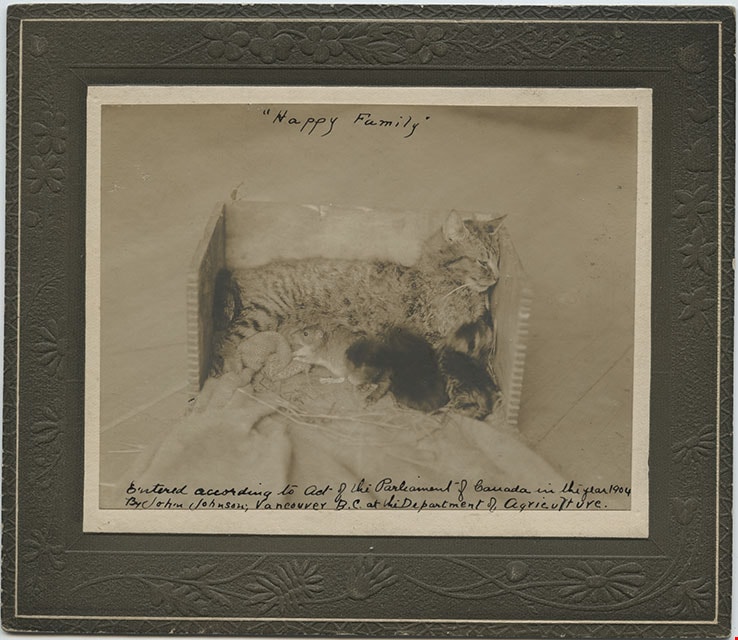
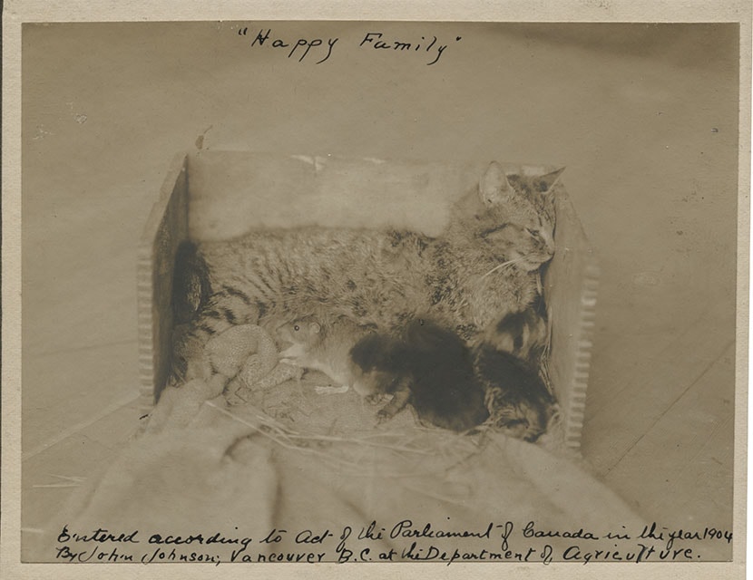
"Happy Family" Cat Diorama
https://search.heritageburnaby.ca/link/museumdescription1092
- Repository
- Burnaby Village Museum
- Date
- [1904]
- Collection/Fonds
- Burnaby Village Museum Photograph collection
- Description Level
- Item
- Physical Description
- 1 photograph : sepia ; 9.8 x 12.4 cm mounted on cardboard 13.8 x 16.0 cm
- Scope and Content
- Photograph of a cat in a diorama box, with a mouse and two kittens cuddling by her side. Annotations on the front of the photo read: "Happy Family" and "Entered according to Act of the Parliament of Canada in the year 1904 by John Johnson; Vancouver B.C. at the Department of Agriculture."
- Repository
- Burnaby Village Museum
- Collection/Fonds
- Burnaby Village Museum Photograph collection
- Description Level
- Item
- Physical Description
- 1 photograph : sepia ; 9.8 x 12.4 cm mounted on cardboard 13.8 x 16.0 cm
- Scope and Content
- Photograph of a cat in a diorama box, with a mouse and two kittens cuddling by her side. Annotations on the front of the photo read: "Happy Family" and "Entered according to Act of the Parliament of Canada in the year 1904 by John Johnson; Vancouver B.C. at the Department of Agriculture."
- Subjects
- Animals - Cats
- Accession Code
- HV972.117.9
- Access Restriction
- No restrictions
- Reproduction Restriction
- No known restrictions
- Date
- [1904]
- Media Type
- Photograph
- Scan Resolution
- 600
- Scan Date
- 2023-04-18
- Notes
- Title based on contents of photograph
Images