Narrow Results By
Decade
- 2020s 40
- 2010s 25
- 2000s 145
- 1990s 157
- 1980s 145
- 1970s 549
- 1960s 250
- 1950s 254
- 1940s 187
- 1930s 166
- 1920s 317
- 1910s 140
- 1900s 62
- 1890s 27
- 1880s 10
- 1870s 5
- 1860s 6
- 1850s 3
- 1840s 1
- 1830s 1
- 1820s 1
- 1810s 2
- 1800s 2
- 1790s 2
- 1780s 2
- 1770s 2
- 1760s 2
- 1750s 2
- 1740s 2
- 1730s 2
- 1720s 2
- 1710s 2
- 1700s 2
- 1690s 2
- 1680s 2
- 1670s 1
- 1660s 1
- 1650s 1
- 1640s 1
- 1630s 1
- 1620s 1
- 1610s 1
- 1600s 1
- 1590s 1
- 1580s 1
- 1570s 1
- 1560s 1
- 1550s 1
- 1540s 1
- 1530s 1
- 1520s 2
- 1510s 1
- 1500s 1
- 1490s 1
- 1480s 1
Subject
- Accidents 1
- Accidents - Automobile Accidents 4
- Adornment 22
- Adornment - Lapel Pins 24
- Advertising Medium 43
- Advertising Medium - Business Cards 8
- Advertising Medium - Flyer 24
- Advertising Medium - Poster 1
- Advertising Medium - Signs and Signboards 29
- Aerial Photographs 12
- Agricultural Tools and Equipment 4
- Agriculture 4
![Claude Hill, the son of Bernard and Marian Hill, [1888]. Item no. 477-933 thumbnail](/media/hpo/_Data/_Archives_Images/_Unrestricted/477/477-933.jpg?width=280)
Interview with Claude Hill and Marion Hill November 7, 1977 - Track 4
https://search.heritageburnaby.ca/link/oralhistory250
- Repository
- City of Burnaby Archives
- Date Range
- 1892-1905
- Length
- 0:04:58
- Summary
- This portion of the interview pertains to A. Claude Hill's memories of how his father cleared land to build a house, including the equipment that was used.
- Repository
- City of Burnaby Archives
- Summary
- This portion of the interview pertains to A. Claude Hill's memories of how his father cleared land to build a house, including the equipment that was used.
- Date Range
- 1892-1905
- Photo Info
- Claude Hill, the son of Bernard and Marian Hill, [1888]. Item no. 477-933
- Length
- 0:04:58
- Names
- Hill, Bernard R
- Subjects
- Land Clearing
- Geographic Access
- Douglas Road
- Canada Way
- Historic Neighbourhood
- Burnaby Lake (Historic Neighbourhood)
- Planning Study Area
- Douglas-Gilpin Area
- Interviewer
- Stevens, Colin
- Interview Date
- November 7, 1977
- Scope and Content
- Recording is of an interview with A. Claude Hill and his wife Marion Hill, conducted by Colin Stevens, November 7, 1977. Major themes discussed are: Christmas traditions and his Deer Lake neighbourhood.
- Biographical Notes
- Claude Hill was born in England about 1885, the eldest son of Marian (Berkeley) and Bernard R. Hill. His younger sibling were Frank, Winnie and Minard Gerald “Gerry.” Claude Hill was named after Bernard’s older brother, Louis Claude Hill. Claude's father, Bernard R. Hill was born in Bengal, India while his father worked for the East Indian Railway. He and his older brother Uncle Claude became strawberry farmers in Burnaby despite their years of training as engineers. Between them, the Hill brothers owned all the land between Burnaby Lake and Deer Lake where Deer Creek runs, and half way around Deer Lake. After the decline in the strawberry industry, Bernard worked as a surveyor for the municipality. He also served as Burnaby Councillor and School Trustee. Bernard built his family home at Douglas Road near Deer Lake in 1892. His oldest child, Claude was seven years old at the time and his first years of school in Burnaby were at Douglas Road. Later, Claude rode a horse and buggy with his younger brother to travel to school in New Westminster. A.Claude Hill married Marion "Mamie" in his early twenties.
- Total Tracks
- 4
- Total Length
- 0:30:00
- Interviewee Name
- Hill, Claude
- Hill, Marion
- Collection/Fonds
- Burnaby Historical Society fonds
- Subseries
- Oral history subseries
- Media Type
- Sound Recording
- Web Notes
- Interview was digitized in 2010 allowing it to be accessible on Heritage Burnaby. The digitization project was initiated by the Community Heritage Commission with support from City of Burnaby Council and the BC History Digitization Program of the Irving K. Barber Learning Centre, University of British Columbia. It was recognized by the Heritage Society of BC with an award in 2012.
Images
![Claude Hill, the son of Bernard and Marian Hill, [1888]. Item no. 477-933 thumbnail](/media/hpo/_Data/_Archives_Images/_Unrestricted/477/477-933.jpg)
Audio Tracks
Track four of interview with Claude Hill and Marion Hill
Track four of interview with Claude Hill and Marion Hill
https://search.heritageburnaby.ca/media/hpo/_Data/_Archives_Oral_Histories/_Unrestricted/MSS137-019-1/MSS137-019-1_Track_4.mp3![Sprott sisters sitting together on a long tressle. Helen Sprott is seated on the right, wearing glasses [1906]. Item no. HV978.1.10 thumbnail](/media/hpo/_Data/_Archives_Images/_Unrestricted/1977/197800010010.jpg?width=280)
Interview with Helen Sprott August 10, 1977 - Track 1
https://search.heritageburnaby.ca/link/oralhistory207
- Repository
- City of Burnaby Archives
- Date Range
- 1900-1908
- Length
- 0:05:47
- Summary
- This portion of the interview pertains to Helen Fanny Sprott's memories of her family's first years of living in Burnaby. She mentions the Hazard House and Mayfield Farms.
- Repository
- City of Burnaby Archives
- Summary
- This portion of the interview pertains to Helen Fanny Sprott's memories of her family's first years of living in Burnaby. She mentions the Hazard House and Mayfield Farms.
- Date Range
- 1900-1908
- Photo Info
- Sprott sisters sitting together on a long tressle. Helen Sprott is seated on the right, wearing glasses [1906]. Item no. HV978.1.10
- Length
- 0:05:47
- Subjects
- Buildings - Residences - Houses
- Geographic Access
- Canada Way
- Burnaby Lake
- Historic Neighbourhood
- Burnaby Lake (Historic Neighbourhood)
- Planning Study Area
- Morley-Buckingham Area
- Interview Date
- August 10, 1977
- Scope and Content
- Recording is of an interview with Helen Sprott, August 10, 1977. Major themes discussed are: the Sprott home.
- Biographical Notes
- Helen Sprott was born in Burnaby on June 22, 1902. Her father, Louis Edgar Sprott and younger brother came out to Burnaby from England, following their older brother Charles F. Sprott. The two younger brothers were in the Merchant Marines together prior to arriving in to Burnaby and learning to farm. Louis Edgar Sprott and Helen Louise F. Nicholls were married June 30, 1900 and stayed at the Haszard House while their own house was being built. By 1902, "the Dovecote" was built and Helen was born. The house was added on to and later renamed "Mayfield Farms." Helen's grandmother and aunt on her mother's side came to live at Mayfield Farms in 1907 or 1908. Helen Sprott was living in Penticton at the time of her death, April 8, 1978 at the age of seventy-five.
- Total Tracks
- 2
- Total Length
- 0:08:57
- Interviewee Name
- Sprott, Helen
- Collection/Fonds
- Burnaby Historical Society fonds
- Subseries
- Oral history subseries
- Media Type
- Sound Recording
Images
![Sprott sisters sitting together on a long tressle. Helen Sprott is seated on the right, wearing glasses [1906]. Item no. HV978.1.10 thumbnail](/media/hpo/_Data/_Archives_Images/_Unrestricted/1977/197800010010.jpg)
Audio Tracks
Track one of interview with Helen Sprott
Track one of interview with Helen Sprott
https://search.heritageburnaby.ca/media/hpo/_Data/_Archives_Oral_Histories/_Unrestricted/MSS137-019-2/MSS137-019-2_Track_1.mp3
Interview with Minard Hill February 9, 1978 - Track 3
https://search.heritageburnaby.ca/link/oralhistory196
- Repository
- City of Burnaby Archives
- Date Range
- 1880-1914
- Length
- 0:10:09
- Summary
- This portion of the interview pertains to Minard Gerald "Gerry" Hill's relatives in England, his father's early life as well as life on the strawberry farm in Burnaby.
- Repository
- City of Burnaby Archives
- Summary
- This portion of the interview pertains to Minard Gerald "Gerry" Hill's relatives in England, his father's early life as well as life on the strawberry farm in Burnaby.
- Date Range
- 1880-1914
- Photo Info
- Minard Gerald Hill in uniform, 1914. Item no. 477-926
- Length
- 0:10:09
- Names
- Hill, Bernard R
- Geographic Access
- Douglas Road
- Canada Way
- Historic Neighbourhood
- Burnaby Lake (Historic Neighbourhood)
- Planning Study Area
- Douglas-Gilpin Area
- Interviewer
- Stevens, Colin
- Interview Date
- February 9, 1978
- Scope and Content
- Recording is of an interview with Minard Gerald "Gerry" Hill conducted by Colin Stevens, February 9, 1978. Major themes discussed are: the Burnaby Lake Neighbourhood, Gilley Brothers Logging Company and his father, Bernard Hill.
- Biographical Notes
- Minard Gerald “Gerry” Hill was born in Burnaby on July 31, 1893 to Marian (Berkeley) and Bernard Richard Hill. He was the youngest child in the family with older siblings Frank, Claude and Winnie. Bernard R. Hill was born in Bengal, India while his father worked for the East Indian Railway. He and his older brother Claude became strawberry farmers in Burnaby despite their years of training as engineers. Between them, the Hill brothers owned all the land between Burnaby Lake and Deer Lake where Deer Creek runs, and half way around Deer Lake. Bernard built his family home at Douglas Road near Deer Lake in 1892. After the decline in the strawberry industry, Bernard worked as a surveyor for the municipality. He also served as Burnaby Councillor and School Trustee. Gerry attended Miss Harriet Woodward’s kindergarten class, and went on to Edmonds School with Miss Ellen Lister as his teacher. He later went to Central high school in New Westminster, often on horseback. Gerry served in World War I, signing his recruitment papers November 9, 1914. When he returned home, he worked felling trees, then as an apprentice surveyor and finally as a carpenter. Minard Gerald “Gerry” Hill married Charlotte Elizabeth “Elizabeth” Vidal on September 28, 1920 and single-handedly built a house for him and his wife about a thousand feet from his parents’ home. He also bought property at Yellow Point, Vancouver Island around this time. By the early 1930s Gerry had moved to Yellow Point permanently and begun work building the lodge. Elizabeth and Gerry’s child, Richard Grant McEwan Hill was born at Ladysmith hospital. Charlotte Elizabeth “Elizabeth” (Vidal) Hill died February 11, 1984 at the age of eighty-seven. Minard Gerald “Gerry” Hill died January 30, 1988 at the age of ninety-three.
- Total Tracks
- 8
- Total Length
- 1:13:56
- Interviewee Name
- Hill, Minard Gerald "Gerry"
- Interview Location
- Yellow Point, Vancouver Island
- Collection/Fonds
- Burnaby Historical Society fonds
- Subseries
- Oral history subseries
- Media Type
- Sound Recording
- Web Notes
- Interview was digitized in 2010 allowing it to be accessible on Heritage Burnaby. The digitization project was initiated by the Community Heritage Commission with support from City of Burnaby Council and the BC History Digitization Program of the Irving K. Barber Learning Centre, University of British Columbia. It was recognized by the Heritage Society of BC with an award in 2012.
Images

Audio Tracks
Track three of interview with Minard Hill
Track three of interview with Minard Hill
https://search.heritageburnaby.ca/media/hpo/_Data/_Archives_Oral_Histories/_Unrestricted/MSS137-018-1/MSS137-018-1_Track_3.mp3![John Barker Lubbock and James Henry Jones, [1930] thumbnail](/media/hpo/_Data/_Archives_Images/_Unrestricted/316/342-005.jpg?width=280)
John Barker Lubbock and James Henry Jones
https://search.heritageburnaby.ca/link/archivedescription37231
- Repository
- City of Burnaby Archives
- Date
- [1930]
- Collection/Fonds
- Burnaby Historical Society fonds
- Description Level
- Item
- Physical Description
- 1 photograph : sepia ; 5.5 x 8 cm
- Scope and Content
- Photograph of John Barker Lubbock, father of the Lubbock children, and his friend, James Henry Jones smoking cigars in the yard at the Lubbock family farm house.
- Repository
- City of Burnaby Archives
- Date
- [1930]
- Collection/Fonds
- Burnaby Historical Society fonds
- Subseries
- Lubbock family subseries
- Physical Description
- 1 photograph : sepia ; 5.5 x 8 cm
- Description Level
- Item
- Record No.
- 342-005
- Access Restriction
- No restrictions
- Reproduction Restriction
- No known restrictions
- Accession Number
- BHS1994-02
- Scope and Content
- Photograph of John Barker Lubbock, father of the Lubbock children, and his friend, James Henry Jones smoking cigars in the yard at the Lubbock family farm house.
- Media Type
- Photograph
- Notes
- Title based on contents of photograph
- Geographic Access
- Grandview Highway
- Canada Way
- Burris Street
- Street Address
- 7803 Burris Street
- Historic Neighbourhood
- Burnaby Lake (Historic Neighbourhood)
- Planning Study Area
- Morley-Buckingham Area
Images
![John Barker Lubbock and James Henry Jones, [1930] thumbnail](/media/hpo/_Data/_Archives_Images/_Unrestricted/316/342-005.jpg)
![John Lubbock with two horses, [1930] thumbnail](/media/hpo/_Data/_Archives_Images/_Unrestricted/316/342-024.jpg?width=280)
John Lubbock with two horses
https://search.heritageburnaby.ca/link/archivedescription37250
- Repository
- City of Burnaby Archives
- Date
- [1930]
- Collection/Fonds
- Burnaby Historical Society fonds
- Description Level
- Item
- Physical Description
- 1 photograph : sepia ; 5 x 7.5 cm
- Scope and Content
- Photograph of John Lubbock with a horse on either side of him, standing in front of his family's farmhouse. He is holding both horses by their halters.
- Repository
- City of Burnaby Archives
- Date
- [1930]
- Collection/Fonds
- Burnaby Historical Society fonds
- Subseries
- Lubbock family subseries
- Physical Description
- 1 photograph : sepia ; 5 x 7.5 cm
- Description Level
- Item
- Record No.
- 342-024
- Access Restriction
- No restrictions
- Reproduction Restriction
- No known restrictions
- Accession Number
- BHS1994-02
- Scope and Content
- Photograph of John Lubbock with a horse on either side of him, standing in front of his family's farmhouse. He is holding both horses by their halters.
- Subjects
- Animals - Horses
- Names
- Lubbock, John
- Media Type
- Photograph
- Notes
- Title based on contents of photograph
- Geographic Access
- Grandview Highway
- Canada Way
- Burris Street
- Street Address
- 7803 Burris Street
- Historic Neighbourhood
- Burnaby Lake (Historic Neighbourhood)
- Planning Study Area
- Morley-Buckingham Area
Images
![John Lubbock with two horses, [1930] thumbnail](/media/hpo/_Data/_Archives_Images/_Unrestricted/316/342-024.jpg)
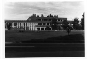
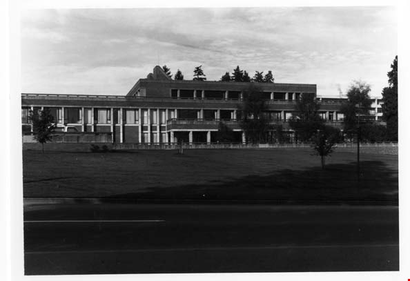
Justice Building
https://search.heritageburnaby.ca/link/archivedescription93616
- Repository
- City of Burnaby Archives
- Date
- October 9, 1977
- Collection/Fonds
- Burnaby Public Library Contemporary Visual Archive Project
- Description Level
- Item
- Physical Description
- 1 photograph : b&w ; 12.5 x 17.5 cm
- Scope and Content
- Photograph of a lawn and the exterior of the Justice Building at the Burnaby Municipal Hall complex. The photograph is taken facing west.
- Repository
- City of Burnaby Archives
- Date
- October 9, 1977
- Collection/Fonds
- Burnaby Public Library Contemporary Visual Archive Project
- Physical Description
- 1 photograph : b&w ; 12.5 x 17.5 cm
- Description Level
- Item
- Record No.
- 556-573
- Access Restriction
- No restrictions
- Reproduction Restriction
- Reproduce for fair dealing purposes only
- Accession Number
- 2017-57
- Scope and Content
- Photograph of a lawn and the exterior of the Justice Building at the Burnaby Municipal Hall complex. The photograph is taken facing west.
- Media Type
- Photograph
- Photographer
- Olsen, John
- Notes
- Title taken from project information form
- Accompanied by a project information form and 1 photograph (b&w negative ; 9.5 x 12.5 cm)
- BPL no. 19
- Geographic Access
- Canada Way
- Street Address
- 6355 Kingsway
- Historic Neighbourhood
- Burnaby Lake (Historic Neighbourhood)
- Planning Study Area
- Douglas-Gilpin Area
Images

Kitty, M. Sprott and Mr. Nicholson
https://search.heritageburnaby.ca/link/archivedescription39433
- Repository
- City of Burnaby Archives
- Date
- 1905
- Collection/Fonds
- Peers Family and Hill Family fonds
- Description Level
- Item
- Physical Description
- 1 photograph : b&w ; 5.5 x 8.1 cm
- Scope and Content
- Photograph of (l t r): Muriel Sprott, Kitty Hill and Malcolm Nicholson. This photograph was likely taken at the home of Mr. Nicholson, on Douglas Road (now Canada Way).
- Repository
- City of Burnaby Archives
- Date
- 1905
- Collection/Fonds
- Peers Family and Hill Family fonds
- Physical Description
- 1 photograph : b&w ; 5.5 x 8.1 cm
- Description Level
- Item
- Record No.
- 477-752
- Access Restriction
- No restrictions
- Reproduction Restriction
- No known restrictions
- Accession Number
- 2007-12
- Scope and Content
- Photograph of (l t r): Muriel Sprott, Kitty Hill and Malcolm Nicholson. This photograph was likely taken at the home of Mr. Nicholson, on Douglas Road (now Canada Way).
- Subjects
- Agriculture - Farms
- Media Type
- Photograph
- Notes
- Title based on caption accompanying photograph
- Geographic Access
- Canada Way
- Historic Neighbourhood
- Burnaby Lake (Historic Neighbourhood)
- Planning Study Area
- Morley-Buckingham Area
Images


Land being cleared for Saint Theresa's Roman Catholic Church
https://search.heritageburnaby.ca/link/museumdescription902
- Repository
- Burnaby Village Museum
- Date
- 1929
- Collection/Fonds
- Burnaby Village Museum Photograph collection
- Description Level
- Item
- Physical Description
- 1 photograph : b&w ; 6.7 x 11.4 cm
- Scope and Content
- Photograph of three unidentified men standing on Douglas Road (later renamed in part Canada Way) with Laurel Street in the background on the left and the site of Saint Theresa's Roman Catholic Church as a lot with blackened stumps. The church was located at the southeast corner of Canada Way and L…
- Repository
- Burnaby Village Museum
- Collection/Fonds
- Burnaby Village Museum Photograph collection
- Description Level
- Item
- Physical Description
- 1 photograph : b&w ; 6.7 x 11.4 cm
- Scope and Content
- Photograph of three unidentified men standing on Douglas Road (later renamed in part Canada Way) with Laurel Street in the background on the left and the site of Saint Theresa's Roman Catholic Church as a lot with blackened stumps. The church was located at the southeast corner of Canada Way and Laurel Street. According to an accompanying note located with the photograph, the first church building burned to the ground the night before it was to be blessed. Insurance for the church had been arranged for by Colonel Dorrell only hours before it was burned and even though signatures had not been affixed to the policy, the insurance company honoured the claim. The second building was smaller and had no basement. Father Trainer was the first priest. This church was torn down in 1974 and a new church building was erected across the road on Canada Way.
- Subjects
- Land Clearing
- Geographic Access
- Douglas Road
- Canada Way
- Laurel Street
- Accession Code
- HV975.105.1
- Access Restriction
- No restrictions
- Reproduction Restriction
- No known restrictions
- Date
- 1929
- Media Type
- Photograph
- Historic Neighbourhood
- Burnaby Lake (Historic Neighbourhood)
- Planning Study Area
- Douglas-Gilpin Area
- Scan Resolution
- 600
- Scan Date
- 2023-06-06
- Notes
- Title based on contents of photograph
- Information on the scope and content of the photograph is taken from an acquisition record from the time of the accession
Images

![Land clearing, [190-] (date of original), copied 1978 thumbnail](/media/hpo/_Data/_BVM_Images/1977/197800010007.jpg?width=280)
Land clearing
https://search.heritageburnaby.ca/link/museumdescription453
- Repository
- Burnaby Village Museum
- Date
- [190-] (date of original), copied 1978
- Collection/Fonds
- Burnaby Village Museum Photograph collection
- Description Level
- Item
- Physical Description
- 1 photograph : b&w ; 20.2 x 25.2 cm print
- Scope and Content
- Photograph of a cleared property with a thick wooded area just behind it. There is a house in the back to the extreme left of the photograph that has been identified as the Haszard house where the Sprott family stayed while building their farmhouse known as "Dovecote." There are unidentified men i…
- Repository
- Burnaby Village Museum
- Collection/Fonds
- Burnaby Village Museum Photograph collection
- Description Level
- Item
- Physical Description
- 1 photograph : b&w ; 20.2 x 25.2 cm print
- Scope and Content
- Photograph of a cleared property with a thick wooded area just behind it. There is a house in the back to the extreme left of the photograph that has been identified as the Haszard house where the Sprott family stayed while building their farmhouse known as "Dovecote." There are unidentified men in the cleared field.
- Subjects
- Land Clearing
- Geographic Access
- Canada Way
- Accession Code
- HV978.1.7
- Access Restriction
- No restrictions
- Reproduction Restriction
- No known restrictions
- Date
- [190-] (date of original), copied 1978
- Media Type
- Photograph
- Historic Neighbourhood
- Burnaby Lake (Historic Neighbourhood)
- Scan Resolution
- 600
- Scan Date
- 2023-08-01
- Notes
- Title based on contents of photograph
Images
![Land clearing, [190-] (date of original), copied 1978 thumbnail](/media/hpo/_Data/_BVM_Images/1977/197800010007.jpg)
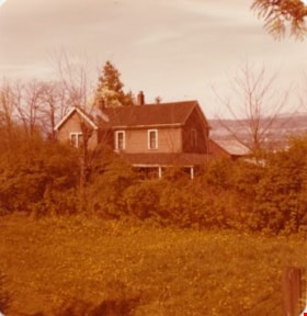
Lewis house
https://search.heritageburnaby.ca/link/archivedescription34855
- Repository
- City of Burnaby Archives
- Date
- March 31, 1985
- Collection/Fonds
- Burnaby Historical Society fonds
- Description Level
- Item
- Physical Description
- 1 photograph : col. ; 8.8 x 11.3 cm
- Scope and Content
- Photograph of the exterior of the house the belonged to the Lewis family on Canada Way.
- Repository
- City of Burnaby Archives
- Date
- March 31, 1985
- Collection/Fonds
- Burnaby Historical Society fonds
- Subseries
- Evelyn Salisbury subseries
- Physical Description
- 1 photograph : col. ; 8.8 x 11.3 cm
- Description Level
- Item
- Record No.
- 145-003
- Access Restriction
- No restrictions
- Reproduction Restriction
- Reproduce for fair dealing purposes only
- Accession Number
- BHS1985-15
- Scope and Content
- Photograph of the exterior of the house the belonged to the Lewis family on Canada Way.
- Subjects
- Buildings - Residential - Houses
- Media Type
- Photograph
- Notes
- Title based on contents of photograph
- Geographic Access
- Canada Way
Images
![Looking down north Poleline Hill, [1908] thumbnail](/media/hpo/_Data/_BVM_Images/1976/1976_0139_0047_001.jpg?width=280)
Looking down north Poleline Hill
https://search.heritageburnaby.ca/link/museumdescription796
- Repository
- Burnaby Village Museum
- Date
- [1908]
- Collection/Fonds
- Burnaby Village Museum Photograph collection
- Description Level
- Item
- Physical Description
- 1 photograph : b&w ; 20.32 x 25.4 cm print
- Scope and Content
- Photograph looking north along the Pole Line Road (later Sperling Avenue). To the far left is Deer Lake and at the top right is Burnaby Lake. The smoke and debris from land clearing is a result of logging operations being carried out by the Doran Brothers logging company, the Deer Lake Mill Company…
- Repository
- Burnaby Village Museum
- Collection/Fonds
- Burnaby Village Museum Photograph collection
- Description Level
- Item
- Physical Description
- 1 photograph : b&w ; 20.32 x 25.4 cm print
- Material Details
- inscribed in pencil, verso, l.l. "Looking down north Poleline Hill (now Sperling) Deer Lake at left. "
- Scope and Content
- Photograph looking north along the Pole Line Road (later Sperling Avenue). To the far left is Deer Lake and at the top right is Burnaby Lake. The smoke and debris from land clearing is a result of logging operations being carried out by the Doran Brothers logging company, the Deer Lake Mill Company. Above Deer Lake, Douglas Road is visible with Claude Hill's Brookfield property (later 6501 Deer Lake Avenue) on the south side of the road and Bernard Hill's home on the north side (later 4990 Canada Way). Just northeast of Brookfield is the George Every-Clayton farm (amongst the trees) on what would later become the Henry and Grace Ceperley estate grounds known as Fairacres. The house in the centre of the picture is the Walker house (later 5255 Sperling Avenue). Mountains can be seen to the north.
- Subjects
- Land Clearing
- Geographic Features - Roads
- Industries - Forestry
- Industries - Logging/lumber
- Geographic Access
- Sperling Avenue
- Deer Lake
- Douglas Road
- Canada Way
- Accession Code
- HV976.139.47
- Access Restriction
- No restrictions
- Reproduction Restriction
- No known restrictions
- Date
- [1908]
- Media Type
- Photograph
- Historic Neighbourhood
- Burnaby Lake (Historic Neighbourhood)
- Planning Study Area
- Morley-Buckingham Area
- Scan Resolution
- 600
- Scan Date
- 2023-06-27
- Notes
- Title based on contents of photograph
Images
![Looking down north Poleline Hill, [1908] thumbnail](/media/hpo/_Data/_BVM_Images/1976/1976_0139_0047_001.jpg)
![Lubbock barnyard, [1958 or 1959] thumbnail](/media/hpo/_Data/_Archives_Images/_Unrestricted/316/342-004.jpg?width=280)
Lubbock barnyard
https://search.heritageburnaby.ca/link/archivedescription37230
- Repository
- City of Burnaby Archives
- Date
- [1958 or 1959]
- Collection/Fonds
- Burnaby Historical Society fonds
- Description Level
- Item
- Physical Description
- 1 photograph : b&w ; 6.5 x 9.5 cm
- Scope and Content
- Photograph of the Lubbock barnyard, with cars from the 1930s and the 1950s parked along the side of the paddock and in front of the barn. Horses are visible in the background.
- Repository
- City of Burnaby Archives
- Date
- [1958 or 1959]
- Collection/Fonds
- Burnaby Historical Society fonds
- Subseries
- Lubbock family subseries
- Physical Description
- 1 photograph : b&w ; 6.5 x 9.5 cm
- Description Level
- Item
- Record No.
- 342-004
- Access Restriction
- No restrictions
- Reproduction Restriction
- Reproduce for fair dealing purposes only
- Accession Number
- BHS1994-02
- Scope and Content
- Photograph of the Lubbock barnyard, with cars from the 1930s and the 1950s parked along the side of the paddock and in front of the barn. Horses are visible in the background.
- Media Type
- Photograph
- Notes
- Title based on contents of photograph
- Geographic Access
- Grandview Highway
- Canada Way
- Burris Street
- Street Address
- 7803 Burris Street
- Historic Neighbourhood
- Burnaby Lake (Historic Neighbourhood)
- Planning Study Area
- Morley-Buckingham Area
Images
![Lubbock barnyard, [1958 or 1959] thumbnail](/media/hpo/_Data/_Archives_Images/_Unrestricted/316/342-004.jpg)
![Lubbock family home and farm, [197-] (date of original), copied 1986 thumbnail](/media/hpo/_Data/_Archives_Images/_Unrestricted/204/204-720.jpg?width=280)
Lubbock family home and farm
https://search.heritageburnaby.ca/link/archivedescription35861
- Repository
- City of Burnaby Archives
- Date
- [197-] (date of original), copied 1986
- Collection/Fonds
- Burnaby Historical Society fonds
- Description Level
- Item
- Physical Description
- 1 photograph : b&w ; 12.7 x 17.8 cm print
- Scope and Content
- Photograph of the Lubbock family home and farm, built in 1898 by Edgar Sprott, brother of former Reeve, Charles F. Sprott. The Lubbock family moved into the house in 1915.
- Repository
- City of Burnaby Archives
- Date
- [197-] (date of original), copied 1986
- Collection/Fonds
- Burnaby Historical Society fonds
- Subseries
- Pioneer Tales subseries
- Physical Description
- 1 photograph : b&w ; 12.7 x 17.8 cm print
- Description Level
- Item
- Record No.
- 204-720
- Access Restriction
- No restrictions
- Reproduction Restriction
- Reproduce for fair dealing purposes only
- Accession Number
- BHS1988-03
- Scope and Content
- Photograph of the Lubbock family home and farm, built in 1898 by Edgar Sprott, brother of former Reeve, Charles F. Sprott. The Lubbock family moved into the house in 1915.
- Media Type
- Photograph
- Notes
- Title based on contents of photograph.
- A note with the photograph indicated that the old street address of this farm was 1 Arbor Lane.
- Geographic Access
- Grandview Highway
- Canada Way
- Burris Street
- Street Address
- 7803 Burris Street
- Historic Neighbourhood
- Burnaby Lake (Historic Neighbourhood)
- Planning Study Area
- Morley-Buckingham Area
Images
![Lubbock family home and farm, [197-] (date of original), copied 1986 thumbnail](/media/hpo/_Data/_Archives_Images/_Unrestricted/204/204-720.jpg)
![Lubbock family home and farm, [197-] (date of original), copied 1986 thumbnail](/media/hpo/_Data/_Archives_Images/_Unrestricted/204/204-721.jpg?width=280)
Lubbock family home and farm
https://search.heritageburnaby.ca/link/archivedescription35862
- Repository
- City of Burnaby Archives
- Date
- [197-] (date of original), copied 1986
- Collection/Fonds
- Burnaby Historical Society fonds
- Description Level
- Item
- Physical Description
- 1 photograph : b&w ; 12.7 x 17.8 cm print
- Scope and Content
- Photograph of cows grazing on the Lubbock farm with the family home seen in the background. The house was built in 1898 by Edgar Sprott, brother of former Reeve, Charles F. Sprott. The Lubbock family moved into the house in 1915.
- Repository
- City of Burnaby Archives
- Date
- [197-] (date of original), copied 1986
- Collection/Fonds
- Burnaby Historical Society fonds
- Subseries
- Pioneer Tales subseries
- Physical Description
- 1 photograph : b&w ; 12.7 x 17.8 cm print
- Description Level
- Item
- Record No.
- 204-721
- Access Restriction
- No restrictions
- Reproduction Restriction
- Reproduce for fair dealing purposes only
- Accession Number
- BHS1988-03
- Scope and Content
- Photograph of cows grazing on the Lubbock farm with the family home seen in the background. The house was built in 1898 by Edgar Sprott, brother of former Reeve, Charles F. Sprott. The Lubbock family moved into the house in 1915.
- Media Type
- Photograph
- Notes
- Title based on contents of photograph.
- A note with this photograph indicated that the old street address of this property was 1 Arbor Lane.
- Geographic Access
- Grandview Highway
- Canada Way
- Burris Street
- Street Address
- 7803 Burris Street
- Historic Neighbourhood
- Burnaby Lake (Historic Neighbourhood)
- Planning Study Area
- Morley-Buckingham Area
Images
![Lubbock family home and farm, [197-] (date of original), copied 1986 thumbnail](/media/hpo/_Data/_Archives_Images/_Unrestricted/204/204-721.jpg)

Lubbock farm
https://search.heritageburnaby.ca/link/archivedescription37248
- Repository
- City of Burnaby Archives
- Date
- April 1976
- Collection/Fonds
- Burnaby Historical Society fonds
- Description Level
- Item
- Physical Description
- 1 photograph : b&w ; 11.5 x 16.5 cm
- Scope and Content
- Photograph of the Lubbock farm and riding stable.
- Repository
- City of Burnaby Archives
- Date
- April 1976
- Collection/Fonds
- Burnaby Historical Society fonds
- Subseries
- Lubbock family subseries
- Physical Description
- 1 photograph : b&w ; 11.5 x 16.5 cm
- Description Level
- Item
- Record No.
- 342-022
- Access Restriction
- No restrictions
- Reproduction Restriction
- Reproduce for fair dealing purposes only
- Accession Number
- BHS1994-02
- Scope and Content
- Photograph of the Lubbock farm and riding stable.
- Subjects
- Agriculture - Farms
- Media Type
- Photograph
- Notes
- Title based on contents of photograph
- Note on verso of photograph reads: "COLUMBIAN 1976 APRIL"
- Geographic Access
- Grandview Highway
- Canada Way
- Burris Street
- Street Address
- 7803 Burris Street
- Historic Neighbourhood
- Burnaby Lake (Historic Neighbourhood)
- Planning Study Area
- Morley-Buckingham Area
Images

![Lubbock farmhouse, [1935] thumbnail](/media/hpo/_Data/_Archives_Images/_Unrestricted/316/342-001.jpg?width=280)
Lubbock farmhouse
https://search.heritageburnaby.ca/link/archivedescription37227
- Repository
- City of Burnaby Archives
- Date
- [1935]
- Collection/Fonds
- Burnaby Historical Society fonds
- Description Level
- Item
- Physical Description
- 1 photograph : sepia ; 5.5 x 8 cm
- Scope and Content
- Photograph of the exterior of the Lubbock farmhouse at Canada Way and Burris.
- Repository
- City of Burnaby Archives
- Date
- [1935]
- Collection/Fonds
- Burnaby Historical Society fonds
- Subseries
- Lubbock family subseries
- Physical Description
- 1 photograph : sepia ; 5.5 x 8 cm
- Description Level
- Item
- Record No.
- 342-001
- Access Restriction
- No restrictions
- Reproduction Restriction
- No known restrictions
- Accession Number
- BHS1994-02
- Scope and Content
- Photograph of the exterior of the Lubbock farmhouse at Canada Way and Burris.
- Media Type
- Photograph
- Notes
- Title based on contents of photograph
- Geographic Access
- Grandview Highway
- Canada Way
- Burris Street
- Street Address
- 7803 Burris Street
- Historic Neighbourhood
- Burnaby Lake (Historic Neighbourhood)
- Planning Study Area
- Morley-Buckingham Area
Images
![Lubbock farmhouse, [1935] thumbnail](/media/hpo/_Data/_Archives_Images/_Unrestricted/316/342-001.jpg)
![Lubbock farmhouse, [1935] thumbnail](/media/hpo/_Data/_Archives_Images/_Unrestricted/316/342-002.jpg?width=280)
Lubbock farmhouse
https://search.heritageburnaby.ca/link/archivedescription37228
- Repository
- City of Burnaby Archives
- Date
- [1935]
- Collection/Fonds
- Burnaby Historical Society fonds
- Description Level
- Item
- Physical Description
- 1 photograph : sepia ; 5.5 x 8 cm
- Scope and Content
- Photograph of the Lubbock family farmhouse at Burris Street and Canada Way.
- Repository
- City of Burnaby Archives
- Date
- [1935]
- Collection/Fonds
- Burnaby Historical Society fonds
- Subseries
- Lubbock family subseries
- Physical Description
- 1 photograph : sepia ; 5.5 x 8 cm
- Description Level
- Item
- Record No.
- 342-002
- Access Restriction
- No restrictions
- Reproduction Restriction
- No known restrictions
- Accession Number
- BHS1994-02
- Scope and Content
- Photograph of the Lubbock family farmhouse at Burris Street and Canada Way.
- Media Type
- Photograph
- Notes
- Title based on contents of photograph
- Geographic Access
- Grandview Highway
- Canada Way
- Burris Street
- Street Address
- 7803 Burris Street
- Historic Neighbourhood
- Burnaby Lake (Historic Neighbourhood)
- Planning Study Area
- Morley-Buckingham Area
Images
![Lubbock farmhouse, [1935] thumbnail](/media/hpo/_Data/_Archives_Images/_Unrestricted/316/342-002.jpg)
![Lubbock farmhouse, [1935] thumbnail](/media/hpo/_Data/_Archives_Images/_Unrestricted/316/342-003.jpg?width=280)
Lubbock farmhouse
https://search.heritageburnaby.ca/link/archivedescription37229
- Repository
- City of Burnaby Archives
- Date
- [1935]
- Collection/Fonds
- Burnaby Historical Society fonds
- Description Level
- Item
- Physical Description
- 1 photograph : sepia ; 5.5 x 8 cm
- Scope and Content
- Photograph of the Lubbock family farmhouse and garden at Burris Street and Canada Way.
- Repository
- City of Burnaby Archives
- Date
- [1935]
- Collection/Fonds
- Burnaby Historical Society fonds
- Subseries
- Lubbock family subseries
- Physical Description
- 1 photograph : sepia ; 5.5 x 8 cm
- Description Level
- Item
- Record No.
- 342-003
- Access Restriction
- No restrictions
- Reproduction Restriction
- No known restrictions
- Accession Number
- BHS1994-02
- Scope and Content
- Photograph of the Lubbock family farmhouse and garden at Burris Street and Canada Way.
- Media Type
- Photograph
- Notes
- Title based on contents of photograph
- Geographic Access
- Grandview Highway
- Canada Way
- Burris Street
- Street Address
- 7803 Burris Street
- Historic Neighbourhood
- Burnaby Lake (Historic Neighbourhood)
- Planning Study Area
- Morley-Buckingham Area
Images
![Lubbock farmhouse, [1935] thumbnail](/media/hpo/_Data/_Archives_Images/_Unrestricted/316/342-003.jpg)

Lubbock's farm
https://search.heritageburnaby.ca/link/archivedescription36517
- Repository
- City of Burnaby Archives
- Date
- 1977
- Collection/Fonds
- Burnaby Historical Society fonds
- Description Level
- Item
- Physical Description
- 1 photograph : col. ; 9 x 8.5 cm
- Scope and Content
- Copyright holder and creator are unknown. Copyright expires in 2053.
- Repository
- City of Burnaby Archives
- Date
- 1977
- Collection/Fonds
- Burnaby Historical Society fonds
- Subseries
- Lubbock family subseries
- Physical Description
- 1 photograph : col. ; 9 x 8.5 cm
- Description Level
- Item
- Record No.
- 289-006
- Access Restriction
- No restrictions
- Reproduction Restriction
- Reproduce for fair dealing purposes only
- Accession Number
- BHS1992-24
- Scope and Content
- Copyright holder and creator are unknown. Copyright expires in 2053.
- Media Type
- Photograph
- Notes
- Title based on contents of photograph
- Geographic Access
- Grandview Highway
- Canada Way
- Burris Street
- Street Address
- 7803 Burris Street
- Historic Neighbourhood
- Burnaby Lake (Historic Neighbourhood)
- Planning Study Area
- Morley-Buckingham Area
Images

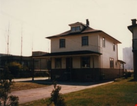
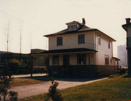
Lubbock's farm house
https://search.heritageburnaby.ca/link/archivedescription36513
- Repository
- City of Burnaby Archives
- Date
- 1977
- Collection/Fonds
- Burnaby Historical Society fonds
- Description Level
- Item
- Physical Description
- 1 photograph : col. ; 9 x 8.5 cm
- Scope and Content
- Photograph of Lubbock's farm house and surrounding trees.
- Repository
- City of Burnaby Archives
- Date
- 1977
- Collection/Fonds
- Burnaby Historical Society fonds
- Subseries
- Lubbock family subseries
- Physical Description
- 1 photograph : col. ; 9 x 8.5 cm
- Description Level
- Item
- Record No.
- 289-002
- Access Restriction
- No restrictions
- Reproduction Restriction
- Reproduce for fair dealing purposes only
- Accession Number
- BHS1992-24
- Scope and Content
- Photograph of Lubbock's farm house and surrounding trees.
- Subjects
- Buildings - Residential - Houses
- Media Type
- Photograph
- Notes
- Title based on contents of photograph
- Geographic Access
- Grandview Highway
- Canada Way
- Burris Street
- Street Address
- 7803 Burris Street
- Historic Neighbourhood
- Burnaby Lake (Historic Neighbourhood)
- Planning Study Area
- Morley-Buckingham Area
Images
