Narrow Results By
Subject
- Buildings - Industrial - Mills 1
- Buildings - Industrial - Saw Mills 1
- Buildings - Recreational - Sports 4
- Buildings - Residential 4
- Buildings - Schools - Universities and Colleges 8
- Ceremonies 3
- Construction 2
- Events 2
- Events - Festivals 1
- Geographic Features - Beaches 1
- Geographic Features - Inlets 2
- Geographic Features - Lakes and Ponds 1
![Velodrome, [2000] thumbnail](/media/hpo/_Data/_Archives_Images/_Unrestricted/535/535-2942-1.jpg?width=280)
Velodrome
https://search.heritageburnaby.ca/link/archivedescription97646
- Repository
- City of Burnaby Archives
- Date
- [2000]
- Collection/Fonds
- Burnaby NewsLeader photograph collection
- Description Level
- File
- Physical Description
- 2 photographs (tiff) : col.
- Scope and Content
- File contains photographs of cyclists and bicycles in the velodrome at the Harry Jerome Sports Centre.
- Repository
- City of Burnaby Archives
- Date
- [2000]
- Collection/Fonds
- Burnaby NewsLeader photograph collection
- Physical Description
- 2 photographs (tiff) : col.
- Description Level
- File
- Record No.
- 535-2942
- Access Restriction
- No restrictions
- Reproduction Restriction
- No restrictions
- Accession Number
- 2018-12
- Scope and Content
- File contains photographs of cyclists and bicycles in the velodrome at the Harry Jerome Sports Centre.
- Media Type
- Photograph
- Notes
- Title based on original file name
- Collected by editorial for use in a November 2001 issue of the Burnaby NewsLeader
- Caption from metadata for 535-2942-1: "The lightweight, high-tech track bikes have only one gear, and no brakes."
- Caption from metadata for 535-2942-2: "Staying in a paceline allows trailing riders to conserve energy while the lead runner bears the brunt of wind resistance."
- Geographic Access
- Barnet Road
- Street Address
- 7564 Barnet Road
- Historic Neighbourhood
- Barnet (Historic Neighbourhood)
- Planning Study Area
- Burnaby Mountain Area
Images
![Velodrome, [2000] thumbnail](/media/hpo/_Data/_Archives_Images/_Unrestricted/535/535-2942-1.jpg)
![SFU soccer game, [2000] thumbnail](/media/hpo/_Data/_Archives_Images/_Unrestricted/535/535-1669-1.jpg?width=280)
SFU soccer game
https://search.heritageburnaby.ca/link/archivedescription95869
- Repository
- City of Burnaby Archives
- Date
- [2000]
- Collection/Fonds
- Burnaby NewsLeader photograph collection
- Description Level
- File
- Physical Description
- 2 photographs (tiff) : col.
- Scope and Content
- File contains photographs of a NAIA Region 1 championship soccer game between Simon Fraser University and Albertson College.
- Repository
- City of Burnaby Archives
- Date
- [2000]
- Collection/Fonds
- Burnaby NewsLeader photograph collection
- Physical Description
- 2 photographs (tiff) : col.
- Description Level
- File
- Record No.
- 535-1669
- Access Restriction
- No restrictions
- Reproduction Restriction
- No restrictions
- Accession Number
- 2018-12
- Scope and Content
- File contains photographs of a NAIA Region 1 championship soccer game between Simon Fraser University and Albertson College.
- Subjects
- Sports - Soccer
- Names
- Simon Fraser University
- Media Type
- Photograph
- Photographer
- Bartel, Mario
- Notes
- Title based on caption
- Collected by editorial for use in a November 2000 issue of the Burnaby NewsLeader
- Caption from metadata for 535-1668-1: "SFU mid-fielder Kevin Todd has to leap high to avoid the sliding tackle by Albertson College defender Pete Arpin, in the championship game of the 2000 NAIA Region 1 playoffs."
- Caption from metadata for 535-1668-2: "SFU's Oystein Ostergren and Albertson College mid-fielder, Ryan Masingill, lunge for the ball in the championship game of the NAIA Region 1 Playoffs, at Terry Fox Field."
- Geographic Access
- Burnaby Mountain Conservation Area
- University Drive
- Street Address
- 8888 University Drive
- Planning Study Area
- Burnaby Mountain Area
Images
![SFU soccer game, [2000] thumbnail](/media/hpo/_Data/_Archives_Images/_Unrestricted/535/535-1669-1.jpg)
![Simon Fraser University graduation, [1999] thumbnail](/media/hpo/_Data/_Archives_Images/_Unrestricted/535/535-3207-1.jpg?width=280)
Simon Fraser University graduation
https://search.heritageburnaby.ca/link/archivedescription98128
- Repository
- City of Burnaby Archives
- Date
- [1999]
- Collection/Fonds
- Burnaby NewsLeader photograph collection
- Description Level
- File
- Physical Description
- 3 photographs (tiff) : col.
- Scope and Content
- File contains photographs of graduating Simon Fraser University students, in caps and gowns, walking in a procession on the footbridge over the pond by the Academic Quadrangle.
- Repository
- City of Burnaby Archives
- Date
- [1999]
- Collection/Fonds
- Burnaby NewsLeader photograph collection
- Physical Description
- 3 photographs (tiff) : col.
- Description Level
- File
- Record No.
- 535-3207
- Access Restriction
- No restrictions
- Reproduction Restriction
- No restrictions
- Accession Number
- 2018-12
- Scope and Content
- File contains photographs of graduating Simon Fraser University students, in caps and gowns, walking in a procession on the footbridge over the pond by the Academic Quadrangle.
- Names
- Simon Fraser University
- Media Type
- Photograph
- Notes
- Title based on contents of file
- Collected by editorial for use in a June 1999 issue of the Burnaby NewsLeader
- Geographic Access
- University Drive
- Burnaby Mountain Conservation Area
- Street Address
- 8888 University Drive
- Planning Study Area
- Burnaby Mountain Area
Images
![Simon Fraser University graduation, [1999] thumbnail](/media/hpo/_Data/_Archives_Images/_Unrestricted/535/535-3207-1.jpg)
![Bagpiper Rob MacNeil, [1999] thumbnail](/media/hpo/_Data/_Archives_Images/_Unrestricted/535/535-3364-1.jpg?width=280)
Bagpiper Rob MacNeil
https://search.heritageburnaby.ca/link/archivedescription98354
- Repository
- City of Burnaby Archives
- Date
- [1999]
- Collection/Fonds
- Burnaby NewsLeader photograph collection
- Description Level
- File
- Physical Description
- 2 photographs (tiff) : col.
- Scope and Content
- File contains photographs of Rob MacNeil, the manager of the Simon Fraser University Pipe Band. Photographs depict MacNeil in silhouette, playing bagpipes on top of Burnaby Mountain with the cityscape visible in the distance, and posing for a portrait.
- Repository
- City of Burnaby Archives
- Date
- [1999]
- Collection/Fonds
- Burnaby NewsLeader photograph collection
- Physical Description
- 2 photographs (tiff) : col.
- Description Level
- File
- Record No.
- 535-3364
- Access Restriction
- No restrictions
- Reproduction Restriction
- No restrictions
- Accession Number
- 2018-12
- Scope and Content
- File contains photographs of Rob MacNeil, the manager of the Simon Fraser University Pipe Band. Photographs depict MacNeil in silhouette, playing bagpipes on top of Burnaby Mountain with the cityscape visible in the distance, and posing for a portrait.
- Media Type
- Photograph
- Photographer
- Bartel, Mario
- Notes
- Title based on caption
- Collected by editorial for use in an October 1999 issue of the Burnaby NewsLeader
- Caption from metadata for 535-3364-1: "Rob MacNeil, the manager of the SFU Pipe Band, plays a lonely lament for the loss of the band's practice field atop Burnaby Mountain, because of a complaint to the Parks Board."
- Geographic Access
- Burnaby Mountain Conservation Area
- Planning Study Area
- Burnaby Mountain Area
Images
![Bagpiper Rob MacNeil, [1999] thumbnail](/media/hpo/_Data/_Archives_Images/_Unrestricted/535/535-3364-1.jpg)

Barnet Marine Park
https://search.heritageburnaby.ca/link/archivedescription91696
- Repository
- City of Burnaby Archives
- Date
- August 25, 1999
- Collection/Fonds
- Doreen Lawson fonds
- Description Level
- File
- Physical Description
- 20 photographs : col. slides ; 35 mm
- Scope and Content
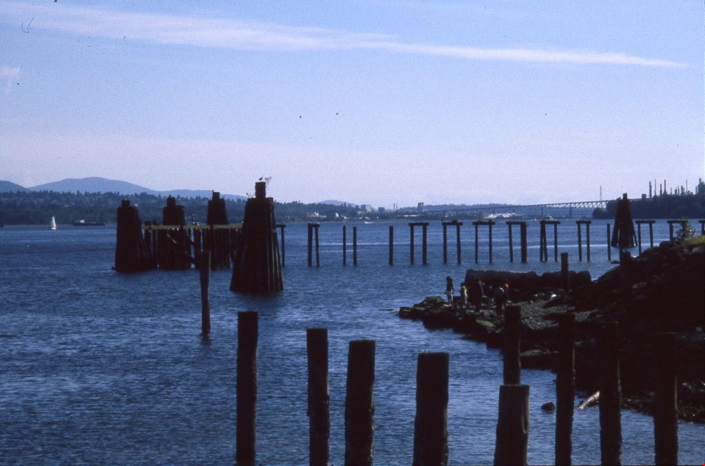
- File consists of photographs of Barnet Marine Park, including the Barnet Beach pilings, people exploring the rocky shoreline and a woman sitting on a bench in the park.
- Repository
- City of Burnaby Archives
- Date
- August 25, 1999
- Collection/Fonds
- Doreen Lawson fonds
- Physical Description
- 20 photographs : col. slides ; 35 mm
- Description Level
- File
- Record No.
- 618-014
- Access Restriction
- No restrictions
- Reproduction Restriction
- No restrictions
- Accession Number
- 2015-15
- Scope and Content
- File consists of photographs of Barnet Marine Park, including the Barnet Beach pilings, people exploring the rocky shoreline and a woman sitting on a bench in the park.
- Media Type
- Photograph
- Photographer
- Lawson, Doreen A.
- Notes
- Title based on contents of photographs
- Geographic Access
- Barnet Marine Park
- Historic Neighbourhood
- Barnet (Historic Neighbourhood)
- Planning Study Area
- Burnaby Mountain Area
Images

Barnet Marine Park
https://search.heritageburnaby.ca/link/archivedescription91581
- Repository
- City of Burnaby Archives
- Date
- August 9, 1996
- Collection/Fonds
- Doreen Lawson fonds
- Description Level
- File
- Physical Description
- 18 photographs : col. slides ; 35 mm
- Scope and Content
- File consists of photographs of Barnet Marine Park, including Barnet Beach pilings, overpass and people preparing kayaks on the shore.
- Repository
- City of Burnaby Archives
- Date
- August 9, 1996
- Collection/Fonds
- Doreen Lawson fonds
- Physical Description
- 18 photographs : col. slides ; 35 mm
- Description Level
- File
- Record No.
- 605-014
- Access Restriction
- No restrictions
- Reproduction Restriction
- No restrictions
- Accession Number
- 2003-30
- Scope and Content
- File consists of photographs of Barnet Marine Park, including Barnet Beach pilings, overpass and people preparing kayaks on the shore.
- Names
- Lawson, Doreen A.
- Media Type
- Photograph
- Photographer
- Lawson, Doreen A.
- Notes
- Title based on contents of photographs
- Note in black in on recto of slide frames of photographs 605-014-1 : 605-014-7, 605-014-9 : 605-014-11, and 605-014-13 reads: "Barnet Beach Pilings"
- Note in black ink on recto of slide frames of photographs 605-014-8 and 605-014-12 reads: "Barnet Beach Kayaks"
- Note in black ink on recto of slide frames of photographs 605-014-14 : 605-014-18 reads: "Barnet Beach Overpass"
- Geographic Access
- Barnet Marine Park
- Historic Neighbourhood
- Barnet (Historic Neighbourhood)
- Planning Study Area
- Burnaby Mountain Area
Images

SFU Rez, Burnaby
https://search.heritageburnaby.ca/link/archivedescription94328
- Repository
- City of Burnaby Archives
- Date
- February 1995
- Collection/Fonds
- Grover, Elliott & Co. Ltd. fonds
- Description Level
- File
- Physical Description
- 24 photographs : col. negatives ; 35 mm
- Scope and Content
- Photographs of the exteriors of Simon Fraser University campus residences, including Shell House, Hamilton Hall, and Townhouses.
- Repository
- City of Burnaby Archives
- Date
- February 1995
- Collection/Fonds
- Grover, Elliott & Co. Ltd. fonds
- Physical Description
- 24 photographs : col. negatives ; 35 mm
- Description Level
- File
- Record No.
- 622-113
- Access Restriction
- No restrictions
- Reproduction Restriction
- No restrictions
- Accession Number
- 2017-39
- Scope and Content
- Photographs of the exteriors of Simon Fraser University campus residences, including Shell House, Hamilton Hall, and Townhouses.
- Names
- Simon Fraser University
- Media Type
- Photograph
- Notes
- Transcribed title
- Title transcribed from envelope photographs were originally housed in
- File no. 95-010-B
- Photographer identified as "J.C."
- Geographic Access
- University Drive
- Street Address
- 8888 University Drive
- Planning Study Area
- Burnaby Mountain Area
SFU Campus/Residential
https://search.heritageburnaby.ca/link/archivedescription93881
- Repository
- City of Burnaby Archives
- Date
- February 1993
- Collection/Fonds
- Grover, Elliott & Co. Ltd. fonds
- Description Level
- File
- Physical Description
- 24 photographs : col. negatives ; 35 mm
- Scope and Content
- Photographs of the exteriors of four Simon Fraser Univeristy (SFU) campus residences.
- Repository
- City of Burnaby Archives
- Date
- February 1993
- Collection/Fonds
- Grover, Elliott & Co. Ltd. fonds
- Physical Description
- 24 photographs : col. negatives ; 35 mm
- Description Level
- File
- Record No.
- 622-064
- Access Restriction
- No restrictions
- Reproduction Restriction
- No restrictions
- Accession Number
- 2017-39
- Scope and Content
- Photographs of the exteriors of four Simon Fraser Univeristy (SFU) campus residences.
- Names
- Simon Fraser University
- Media Type
- Photograph
- Notes
- Transcribed title
- Title transcribed from envelope photographs were originally housed in
- File no. 93-050-B
- Geographic Access
- Burnaby Mountain Conservation Area
- Planning Study Area
- Burnaby Mountain Area
SFU Residence
https://search.heritageburnaby.ca/link/archivedescription93721
- Repository
- City of Burnaby Archives
- Date
- 1989
- Collection/Fonds
- Grover, Elliott & Co. Ltd. fonds
- Description Level
- File
- Physical Description
- 25 photographs : col. negatives ; 35 mm
- Scope and Content
- Photographs of the exteriors of four Simon Fraser University (SFU) residences: Shell House, Madge Hogarth House, Louis Riel House, and McTaggart-Cowan Hall
- Repository
- City of Burnaby Archives
- Date
- 1989
- Collection/Fonds
- Grover, Elliott & Co. Ltd. fonds
- Physical Description
- 25 photographs : col. negatives ; 35 mm
- Description Level
- File
- Record No.
- 622-010
- Access Restriction
- No restrictions
- Reproduction Restriction
- No restrictions
- Accession Number
- 2017-39
- Scope and Content
- Photographs of the exteriors of four Simon Fraser University (SFU) residences: Shell House, Madge Hogarth House, Louis Riel House, and McTaggart-Cowan Hall
- Names
- Simon Fraser University
- Media Type
- Photograph
- Notes
- Transcribed title
- Title transcribed from original print envelope
- Photographs 622-010-1 : 622-010-6 depict Madge Hogarth House
- Photographs 622-010-7 : 622-010-12 depict Shell House
- Photographs 622-010-13 : 622-010-15 and 622-010-19 : 622-010-21 depict Louis Riel Hous
- Photographs 622-010-16 : 622-010-18 and 622-010-22 : 622-010-25 depict McTaggart-Cowan Hall
- Residences were identified using notes on verso of accompanying prints
- Geographic Access
- Burnaby Mountain Conservation Area
- Planning Study Area
- Burnaby Mountain Area

Municipality of Burnaby - Volume XVI and Volume XVII
https://search.heritageburnaby.ca/link/museumdescription8684
- Repository
- Burnaby Village Museum
- Date
- May 1927
- Collection/Fonds
- Burnaby Village Museum Map collection
- Description Level
- File
- Physical Description
- 4 plans on 4 sheets : col. lithographic prints ; 63.5 x 53.5 cm folded to 53 x 31.5 cm
- Scope and Content
- File consists of four pages of plans removed from a bound book containing a series of fire insurance plans of the Municipality of Burnaby. Page "D" is titled: "GREATER VANCOUVER B.C. / VOLUME XVI / Surveyed _ May 1927 / MUNICIPALITY OF / BURNABY / PLAN DEPT. FIRE BRANCH _ B.C. INSURANCE UNDERWRITE…
- Repository
- Burnaby Village Museum
- Collection/Fonds
- Burnaby Village Museum Map collection
- Description Level
- File
- Physical Description
- 4 plans on 4 sheets : col. lithographic prints ; 63.5 x 53.5 cm folded to 53 x 31.5 cm
- Material Details
- Scale [1:1200] and [1:6000]
- Scope and Content
- File consists of four pages of plans removed from a bound book containing a series of fire insurance plans of the Municipality of Burnaby. Page "D" is titled: "GREATER VANCOUVER B.C. / VOLUME XVI / Surveyed _ May 1927 / MUNICIPALITY OF / BURNABY / PLAN DEPT. FIRE BRANCH _ B.C. INSURANCE UNDERWRITERS ASSN." / KEY PLAN". Plans covered in this "Key Plan" are numbered 1601 to 1626, 1632 and 1651 covering District Lots: 15; 31; 100 to 102; 114; 141 to 144; 147 and 148; 209 to 214. Plan "E" is part of "GREATER VANCOUVER B.C. / VOLUME XVII / Municipality of Burnaby / May 1927" and covers plans: 1701 to 1705; 1711 to 1715; 1723 to 1727; 1729 to 1733; 1737 to 1742 and District Lots: 68 to 74; 80 to 84; 32 to 35 and 38 to 39. Plan marked "F" is a key plan titled: "GREATER VANCOUVER B.C. / VOLUME XVII / Surveyed _ May 1927 / MUNICIPALITY OF / BURNABY and covers plans: 1706 to 1710; 1716 to 1722; 1734 and 1735; 1743 to 1752 and District Lots: 42 to 44; 59; 75 to 80; 83 to 87; 89 to 93 and 130. Plan "1729" is part of "GREATER VANCOUVER B.C. / VOLUME XVII / Municipality of Burnaby / May 1927" and covers District Lots 34 and 35.
- Responsibility
- British Columbia Underwriters' Association
- Accession Code
- HV972.111.6
- Access Restriction
- No restrictions
- Reproduction Restriction
- May be restricted by third party rights
- Date
- May 1927
- Media Type
- Cartographic Material
- Historic Neighbourhood
- Barnet (Historic Neighbourhood)
- Burquitlam (Historic Neighbourhood)
- Central Park (Historic Neighbourhood)
- Burnaby Lake (Historic Neighbourhood)
- Broadview (Historic Neighbourhood)
- Planning Study Area
- Burnaby Mountain Area
- Lyndhurst Area
- Lake City Area
- Cascade-Schou Area
- Garden Village Area
- Douglas-Gilpin Area
- Oakalla Area
- Scan Resolution
- 400
- Scan Date
- 2021-11-18
- Notes
- Title based on content of plans
- See also BV987.1.70d for revised versions of plans
- Scale is measured 1 inch = 500 feet


