Narrow Results By
Subject
- Accidents - Automobile Accidents 2
- Advertising Medium 1
- Advertising Medium - Signs and Signboards 12
- Aerial Photographs 15
- Agricultural Tools and Equipment 9
- Agricultural Tools and Equipment - Gardening Equipment 1
- Agricultural Tools and Equipment - Plows 6
- Agriculture 2
- Agriculture - Crops 12
- Agriculture - Farms 110
- Agriculture - Fruit and Berries 9
- Agriculture - Poultry 1

1982 - Moving the Roberts House
https://search.heritageburnaby.ca/link/archivedescription91891
- Repository
- City of Burnaby Archives
- Date
- 1982
- Collection/Fonds
- Small family fonds
- Description Level
- Item
- Physical Description
- 1 photograph : col. ; 10 cm x 15 cm
- Scope and Content
- Photograph of an excavator clearing the land between 5496 Dominion Street and Douglas Road. The three lots in this area were subdivided into six 33 foot lots and cleared for the construction of six new houses.
- Repository
- City of Burnaby Archives
- Date
- 1982
- Collection/Fonds
- Small family fonds
- Physical Description
- 1 photograph : col. ; 10 cm x 15 cm
- Description Level
- Item
- Record No.
- 620-072
- Access Restriction
- No restrictions
- Reproduction Restriction
- No reproduction permitted
- Accession Number
- 2017-01
- Scope and Content
- Photograph of an excavator clearing the land between 5496 Dominion Street and Douglas Road. The three lots in this area were subdivided into six 33 foot lots and cleared for the construction of six new houses.
- Media Type
- Photograph
- Notes
- Transcribed title
- Title transcribed from donor's notes
- Note in blue ink on verso of photograph reads: "P.14"
- Note in pencil on verso of photograph reads: "13"
- Street Address
- 5496 Dominion Street
- Historic Neighbourhood
- Burnaby Lake (Historic Neighbourhood)
- Planning Study Area
- Ardingley-Sprott Area
Images


1982 - Moving the Roberts House
https://search.heritageburnaby.ca/link/archivedescription91892
- Repository
- City of Burnaby Archives
- Date
- 1982
- Collection/Fonds
- Small family fonds
- Description Level
- Item
- Physical Description
- 1 photograph : col. ; 15 cm x 10 cm
- Scope and Content
- Photograph of a labourer removing the old foundation and boulders from the 5496 Dominion Street property with a jackhammer. The house located at 5511 Norfolk Street is visible in the background.
- Repository
- City of Burnaby Archives
- Date
- 1982
- Collection/Fonds
- Small family fonds
- Physical Description
- 1 photograph : col. ; 15 cm x 10 cm
- Description Level
- Item
- Record No.
- 620-073
- Access Restriction
- No restrictions
- Reproduction Restriction
- No reproduction permitted
- Accession Number
- 2017-01
- Scope and Content
- Photograph of a labourer removing the old foundation and boulders from the 5496 Dominion Street property with a jackhammer. The house located at 5511 Norfolk Street is visible in the background.
- Media Type
- Photograph
- Notes
- Transcribed title
- Title transcribed from donor's notes
- Note in blue ink on verso of photograph reads: "P.15"
- Note in pencil on verso of photograph reads: "14"
- 5511 Norfolk Street was previously numbered 3149 Norfolk Street. It was later subdivided into two lots: 5503 and 5521 Norfolk Street.
- Street Address
- 5511 Norfolk Street
- 5496 Dominion Street
- Historic Neighbourhood
- Burnaby Lake (Historic Neighbourhood)
- Planning Study Area
- Ardingley-Sprott Area
Images


1982 - Moving the Roberts House
https://search.heritageburnaby.ca/link/archivedescription91893
- Repository
- City of Burnaby Archives
- Date
- 1982 (date of original), copied 2017
- Collection/Fonds
- Small family fonds
- Description Level
- Item
- Physical Description
- 1 photograph : col. copy print ; 10 cm x 15 cm
- Scope and Content
- Photograph of new houses being constructed on the 33 foot lots between 5496 Dominion Street and Douglas Road. Framing is complete and the houses' roofs and windows are installed.
- Repository
- City of Burnaby Archives
- Date
- 1982 (date of original), copied 2017
- Collection/Fonds
- Small family fonds
- Physical Description
- 1 photograph : col. copy print ; 10 cm x 15 cm
- Description Level
- Item
- Record No.
- 620-074
- Access Restriction
- No restrictions
- Reproduction Restriction
- No reproduction permitted
- Accession Number
- 2017-01
- Scope and Content
- Photograph of new houses being constructed on the 33 foot lots between 5496 Dominion Street and Douglas Road. Framing is complete and the houses' roofs and windows are installed.
- Media Type
- Photograph
- Notes
- Transcribed title
- Title transcribed from donor's notes
- Note in blue ink on verso of photograph reads: "P.16"
- Geographic Access
- Dominion Street
- Street Address
- 5496 Dominion Street
- Historic Neighbourhood
- Burnaby Lake (Historic Neighbourhood)
- Planning Study Area
- Ardingley-Sprott Area
Images

![Mayor Lewarne and Council Members, [between 1981 and 1983] thumbnail](/media/hpo/_Data/_Archives_Images/_Unrestricted/316/351-001.jpg?width=280)
Mayor Lewarne and Council Members
https://search.heritageburnaby.ca/link/archivedescription37331
- Repository
- City of Burnaby Archives
- Date
- [between 1981 and 1983]
- Collection/Fonds
- Burnaby Historical Society fonds
- Description Level
- Item
- Physical Description
- 1 photograph : col. ; 20 x 25 cm
- Scope and Content
- Photograph of Mayor William Lewarne and Council members, 1981-1983. Back row (l to r): Alan Emmott, Egon Nikolai, Vic Stusiak, Donald Brown, Doug Drummond. Front row (l to r) George McLean, Tom Constable, William Lewarne, and Doreen Lawson. The photograph was taken in Council Chambers at Burnaby…
- Repository
- City of Burnaby Archives
- Date
- [between 1981 and 1983]
- Collection/Fonds
- Burnaby Historical Society fonds
- Subseries
- Municipal record subseries
- Physical Description
- 1 photograph : col. ; 20 x 25 cm
- Description Level
- Item
- Record No.
- 351-001
- Access Restriction
- No restrictions
- Reproduction Restriction
- Reproduce for fair dealing purposes only
- Accession Number
- BHS1997-11
- Scope and Content
- Photograph of Mayor William Lewarne and Council members, 1981-1983. Back row (l to r): Alan Emmott, Egon Nikolai, Vic Stusiak, Donald Brown, Doug Drummond. Front row (l to r) George McLean, Tom Constable, William Lewarne, and Doreen Lawson. The photograph was taken in Council Chambers at Burnaby Municipal Hall.
- Subjects
- Officials - Alderman and Councillors
- Buildings - Civic - City Halls
- Officials - Mayors and Reeves
- Names
- Emmott, Alan H.
- Nikolai, Egon
- Stusiak, Victor V. "Vic"
- Brown, Donald N. "Don"
- Drummond, Douglas P. "Doug"
- McLean, George H.F.
- Constable, Thomas W. "Tom"
- Lewarne, William A. "Bill"
- Lawson, Doreen A.
- Burnaby City Hall
- Media Type
- Photograph
- Notes
- Title based on contents of photograph
- Geographic Access
- Canada Way
- Street Address
- 4949 Canada Way
- Historic Neighbourhood
- Burnaby Lake (Historic Neighbourhood)
- Planning Study Area
- Douglas-Gilpin Area
Images
![Mayor Lewarne and Council Members, [between 1981 and 1983] thumbnail](/media/hpo/_Data/_Archives_Images/_Unrestricted/316/351-001.jpg)
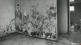
Mold and watermarks
https://search.heritageburnaby.ca/link/archivedescription45406
- Repository
- City of Burnaby Archives
- Date
- August 31, 1981
- Collection/Fonds
- Columbian Newspaper collection
- Description Level
- Item
- Physical Description
- 1 photograph : b&w ; 12.5 x 22.5 cm
- Scope and Content
- Photograph of mold growing on a wall in a basement on Norland Avenue in Burnaby. The owner of the house, Jocelan Wise blames the mold and watermarks on a faulty storm sewer put in by the municipality in 1977.
- Repository
- City of Burnaby Archives
- Date
- August 31, 1981
- Collection/Fonds
- Columbian Newspaper collection
- Physical Description
- 1 photograph : b&w ; 12.5 x 22.5 cm
- Description Level
- Item
- Record No.
- 480-301
- Access Restriction
- No restrictions
- Reproduction Restriction
- No restrictions
- Accession Number
- 2003-02
- Scope and Content
- Photograph of mold growing on a wall in a basement on Norland Avenue in Burnaby. The owner of the house, Jocelan Wise blames the mold and watermarks on a faulty storm sewer put in by the municipality in 1977.
- Media Type
- Photograph
- Photographer
- Battistoni, Peter
- Notes
- Title based on contents of photograph
- Geographic Access
- Norland Avenue
- Historic Neighbourhood
- Burnaby Lake (Historic Neighbourhood)
- Planning Study Area
- Ardingley-Sprott Area
Images

Schedule "G" - Heritage Village Museum: Area covered by agreement with Century Park Museum Association
https://search.heritageburnaby.ca/link/museumdescription3868
- Repository
- Burnaby Village Museum
- Date
- June 1981
- Collection/Fonds
- Donald Copan collection
- Description Level
- Item
- Physical Description
- 1 architectural drawing : ink on paper ; 36 x 22 cm
- Scope and Content
- Item consists of a one page schedule from an unidentified document, showing a plan drawing of the Heritage Village site and indicating areas covered by agreement with the Century Park Museum Association (CPMA) and areas for potential future expansion of the village.
- Repository
- Burnaby Village Museum
- Collection/Fonds
- Donald Copan collection
- Description Level
- Item
- Physical Description
- 1 architectural drawing : ink on paper ; 36 x 22 cm
- Scope and Content
- Item consists of a one page schedule from an unidentified document, showing a plan drawing of the Heritage Village site and indicating areas covered by agreement with the Century Park Museum Association (CPMA) and areas for potential future expansion of the village.
- Names
- Burnaby Village Museum
- Accession Code
- BV005.54.785
- Access Restriction
- Subject to FIPPA
- Reproduction Restriction
- Reproductions subject to FIPPA
- Date
- June 1981
- Media Type
- Architectural Drawing
- Historic Neighbourhood
- Burnaby Lake (Historic Neighbourhood)
- Planning Study Area
- Morley-Buckingham Area
- Notes
- Title based on contents of drawing
![Looking northwest from Roberts' property, [1980] thumbnail](/media/hpo/_Data/_Archives_Images/_Unrestricted/600/620-033.jpg?width=280)
Looking northwest from Roberts' property
https://search.heritageburnaby.ca/link/archivedescription91852
- Repository
- City of Burnaby Archives
- Date
- [1980]
- Collection/Fonds
- Small family fonds
- Description Level
- Item
- Physical Description
- 1 photograph : col. copy print ; 10 cm x 15 cm
- Scope and Content
- Photograph of the Roberts' yard at 5538 Dominion Street covered in snow. The tennis court has been converted into a fruit and vegetable garden and the supports of a row of raspberry canes and small fruit free are visible to the right. The photograph was taken from the Roberts' property, looking n…
- Repository
- City of Burnaby Archives
- Date
- [1980]
- Collection/Fonds
- Small family fonds
- Physical Description
- 1 photograph : col. copy print ; 10 cm x 15 cm
- Description Level
- Item
- Record No.
- 620-033
- Access Restriction
- No restrictions
- Reproduction Restriction
- No reproduction permitted
- Accession Number
- 2017-01
- Scope and Content
- Photograph of the Roberts' yard at 5538 Dominion Street covered in snow. The tennis court has been converted into a fruit and vegetable garden and the supports of a row of raspberry canes and small fruit free are visible to the right. The photograph was taken from the Roberts' property, looking northwest.
- Subjects
- Natural Phenomena - Snow
- Media Type
- Photograph
- Notes
- Transcribed title
- Title transcribed from donor's notes
- Note in blue ink on verso of photograph reads: "P.33"
- Note in blue ink on verso of photograph reads: "Tennis Court in the Snow / Dec 1980 (?)"
- 5118 Douglas Road renumbered to 3131 Douglas Road in 1958 and to 5538 Dominion Street in 1970 or 1971
- Street Address
- 3131 Douglas Road
- 5118 Douglas Road
- 5538 Dominion Street
- Historic Neighbourhood
- Burnaby Lake (Historic Neighbourhood)
- Planning Study Area
- Ardingley-Sprott Area
Images
![Looking northwest from Roberts' property, [1980] thumbnail](/media/hpo/_Data/_Archives_Images/_Unrestricted/600/620-033.jpg)
![Burnaby Art Gallery, [1980] thumbnail](/media/hpo/_Data/_Archives_Images/_Unrestricted/316/349-002.jpg?width=280)
Burnaby Art Gallery
https://search.heritageburnaby.ca/link/archivedescription37306
- Repository
- City of Burnaby Archives
- Date
- [1980]
- Collection/Fonds
- Burnaby Historical Society fonds
- Description Level
- Item
- Physical Description
- 1 photograph : b&w ; 10 x 15 cm
- Scope and Content
- Photograph of the exterior of the Burnaby Art Gallery and parking lot. This building was formerly the H. Ceperley family's Fairacres estate, built in 1911.
- Repository
- City of Burnaby Archives
- Date
- [1980]
- Collection/Fonds
- Burnaby Historical Society fonds
- Subseries
- Jim Wolf subseries
- Physical Description
- 1 photograph : b&w ; 10 x 15 cm
- Description Level
- Item
- Record No.
- 349-002
- Access Restriction
- No restrictions
- Reproduction Restriction
- Reproduce for fair dealing purposes only
- Accession Number
- BHS1997-09
- Scope and Content
- Photograph of the exterior of the Burnaby Art Gallery and parking lot. This building was formerly the H. Ceperley family's Fairacres estate, built in 1911.
- Names
- Burnaby Art Gallery
- Media Type
- Photograph
- Photographer
- Houghtaling, Kim
- Notes
- Title based on contents of photograph
- Geographic Access
- Deer Lake Avenue
- Street Address
- 6344 Deer Lake Avenue
- Historic Neighbourhood
- Burnaby Lake (Historic Neighbourhood)
- Planning Study Area
- Douglas-Gilpin Area
Images
![Burnaby Art Gallery, [1980] thumbnail](/media/hpo/_Data/_Archives_Images/_Unrestricted/316/349-002.jpg)
![Parking Lot and Burnaby Art Gallery, [1980] thumbnail](/media/hpo/_Data/_Archives_Images/_Unrestricted/371/420-002.jpg?width=280)
Parking Lot and Burnaby Art Gallery
https://search.heritageburnaby.ca/link/archivedescription38368
- Repository
- City of Burnaby Archives
- Date
- [1980]
- Collection/Fonds
- Burnaby Historical Society fonds
- Description Level
- Item
- Physical Description
- 1 photograph : b&w ; 10 x 14.9 cm
- Scope and Content
- Photograph of the parking lot and entrance to the Burnaby Art Gallery (formerly the Ceperley House) in Deer Lake park.
- Repository
- City of Burnaby Archives
- Date
- [1980]
- Collection/Fonds
- Burnaby Historical Society fonds
- Subseries
- Municipal record subseries
- Physical Description
- 1 photograph : b&w ; 10 x 14.9 cm
- Description Level
- Item
- Record No.
- 420-002
- Access Restriction
- No restrictions
- Reproduction Restriction
- Reproduce for fair dealing purposes only
- Accession Number
- BHS2001-09
- Scope and Content
- Photograph of the parking lot and entrance to the Burnaby Art Gallery (formerly the Ceperley House) in Deer Lake park.
- Names
- Burnaby Art Gallery
- Media Type
- Photograph
- Notes
- Title based on contents of photograph.
- Geographic Access
- Deer Lake Avenue
- Street Address
- 6344 Deer Lake Avenue
- Historic Neighbourhood
- Burnaby Lake (Historic Neighbourhood)
- Planning Study Area
- Douglas-Gilpin Area
Images
![Parking Lot and Burnaby Art Gallery, [1980] thumbnail](/media/hpo/_Data/_Archives_Images/_Unrestricted/371/420-002.jpg)
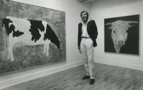
Robin Mayor
https://search.heritageburnaby.ca/link/archivedescription45168
- Repository
- City of Burnaby Archives
- Date
- August 20, 1980, published August 25, 1980
- Collection/Fonds
- Columbian Newspaper collection
- Description Level
- Item
- Physical Description
- 1 photograph : b&w ; 14 x 22.5 cm
- Scope and Content
- Photograph of Robin Mayor standing inbetween two of his paintings at the Burnaby Art Gallery. The painting of the jersey cow on the left is "Linda the Navigator" and the one on the right is "Curly". Both paintings are acrylic and mixed media on canvas.
- Repository
- City of Burnaby Archives
- Date
- August 20, 1980, published August 25, 1980
- Collection/Fonds
- Columbian Newspaper collection
- Physical Description
- 1 photograph : b&w ; 14 x 22.5 cm
- Description Level
- Item
- Record No.
- 480-064
- Access Restriction
- No restrictions
- Reproduction Restriction
- No restrictions
- Accession Number
- 2003-02
- Scope and Content
- Photograph of Robin Mayor standing inbetween two of his paintings at the Burnaby Art Gallery. The painting of the jersey cow on the left is "Linda the Navigator" and the one on the right is "Curly". Both paintings are acrylic and mixed media on canvas.
- Media Type
- Photograph
- Photographer
- Battistoni, Peter
- Notes
- Title based on contents of photograph
- Newspaper clipping attached to verso of photograph reads: "COWS ARE BEAUTIFUL...Artist Robin Mayor poses with two of his unique cattle pictures at the Burnaby Art Gallery. At left is Linda the Navigator; at right, Curly. Both are acrylics and mixed media on canvas."
- Geographic Access
- Deer Lake Avenue
- Street Address
- 6344 Deer Lake Avenue
- Historic Neighbourhood
- Burnaby Lake (Historic Neighbourhood)
- Planning Study Area
- Douglas-Gilpin Area
Images

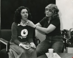
Margaret Aasen and Gaby Sander
https://search.heritageburnaby.ca/link/archivedescription45457
- Repository
- City of Burnaby Archives
- Date
- February 1980
- Collection/Fonds
- Columbian Newspaper collection
- Description Level
- Item
- Physical Description
- 1 photograph : b&w ; 19.5 x 24 cm
- Scope and Content
- Photograph of student actor Margaret Aasen acting out symptoms for psychiatric nursing student Gaby Sander to diagnose. This is part of the patient simulation teaching method designed to give student nurses more experience and confidence before they go out into the work force.
- Repository
- City of Burnaby Archives
- Date
- February 1980
- Collection/Fonds
- Columbian Newspaper collection
- Physical Description
- 1 photograph : b&w ; 19.5 x 24 cm
- Description Level
- Item
- Record No.
- 480-352
- Access Restriction
- No restrictions
- Reproduction Restriction
- Reproduce for fair dealing purposes only
- Accession Number
- 2003-02
- Scope and Content
- Photograph of student actor Margaret Aasen acting out symptoms for psychiatric nursing student Gaby Sander to diagnose. This is part of the patient simulation teaching method designed to give student nurses more experience and confidence before they go out into the work force.
- Subjects
- Occupations - Actors
- Occupations - Nurses
- Media Type
- Photograph
- Photographer
- Braid, Tom
- Notes
- Title based on contents of photograph
- Newspaper clipping attached to verso of photograph reads: "Student actor Margeret [sic] Aasen performs for student nurse Gaby Sander."
- Geographic Access
- Willingdon Avenue
- Street Address
- 3700 Willingdon Avenue
- Historic Neighbourhood
- Burnaby Lake (Historic Neighbourhood)
- Planning Study Area
- Douglas-Gilpin Area
Images

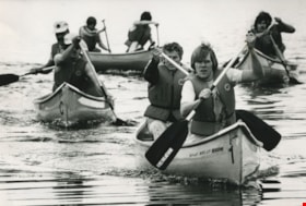
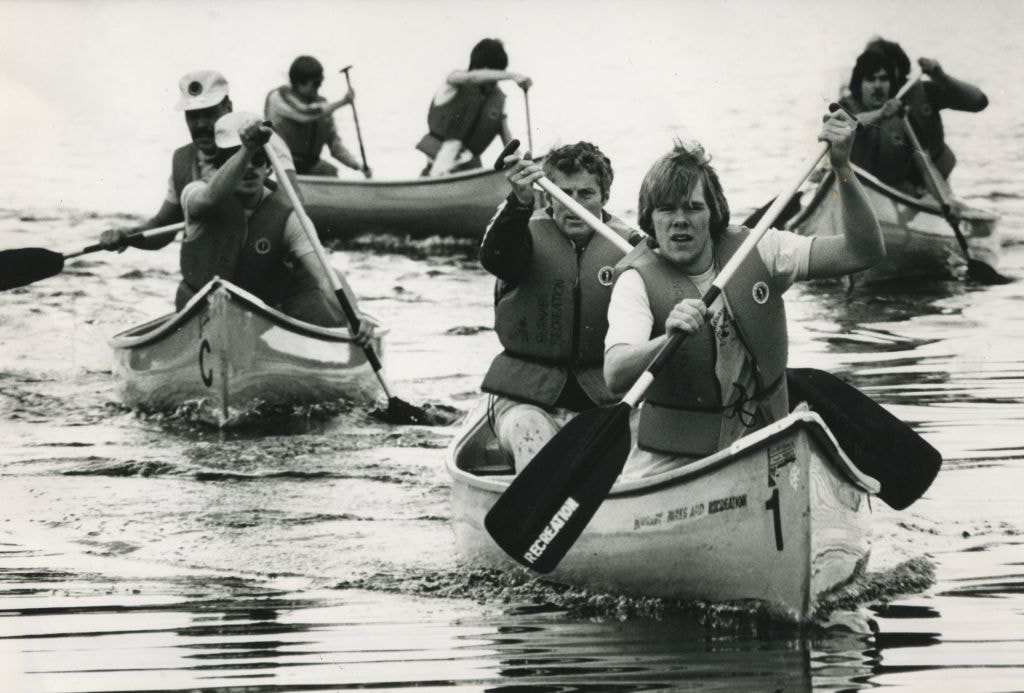
Canoeing on Deer Lake
https://search.heritageburnaby.ca/link/archivedescription45973
- Repository
- City of Burnaby Archives
- Date
- June 1980
- Collection/Fonds
- Columbian Newspaper collection
- Description Level
- Item
- Physical Description
- 1 photograph : b&w ; 17 x 24 cm
- Scope and Content
- Photograph of people canoeing on Deer Lake as part of the 10-kilometre "Great Explorer Race". This was the "Funfest" finale, and was won by the Burnaby Rugby Club.
- Repository
- City of Burnaby Archives
- Date
- June 1980
- Collection/Fonds
- Columbian Newspaper collection
- Physical Description
- 1 photograph : b&w ; 17 x 24 cm
- Description Level
- Item
- Record No.
- 480-868
- Access Restriction
- No restrictions
- Reproduction Restriction
- No restrictions
- Accession Number
- 2003-02
- Scope and Content
- Photograph of people canoeing on Deer Lake as part of the 10-kilometre "Great Explorer Race". This was the "Funfest" finale, and was won by the Burnaby Rugby Club.
- Media Type
- Photograph
- Photographer
- Hodge, Craig
- Notes
- Title based on contents of photograph
- Newspaper clipping attached to verso of photograph reads: "Canoeing along Burnaby Lake was just part of the gruelling 10-kilometre Great Explorer race held Sunday as Funfest finale and won by the Burnaby Rugby Club."
- Geographic Access
- Deer Lake
- Historic Neighbourhood
- Burnaby Lake (Historic Neighbourhood)
- Planning Study Area
- Morley-Buckingham Area
- Oakalla Area
Images
![Burnaby Lake, [198-] thumbnail](/media/hpo/_Data/_Archives_Images/_Unrestricted/480/480-873.jpg?width=280)
Burnaby Lake
https://search.heritageburnaby.ca/link/archivedescription45978
- Repository
- City of Burnaby Archives
- Date
- [198-]
- Collection/Fonds
- Columbian Newspaper collection
- Description Level
- Item
- Physical Description
- 1 photograph : b&w ; 12 x 23 cm
- Scope and Content
- Photograph of Burnaby Lake.
- Repository
- City of Burnaby Archives
- Date
- [198-]
- Collection/Fonds
- Columbian Newspaper collection
- Physical Description
- 1 photograph : b&w ; 12 x 23 cm
- Description Level
- Item
- Record No.
- 480-873
- Access Restriction
- No restrictions
- Reproduction Restriction
- Reproduce for fair dealing purposes only
- Accession Number
- 2003-02
- Scope and Content
- Photograph of Burnaby Lake.
- Media Type
- Photograph
- Photographer
- Donnelly, David
- Notes
- Title based on contents of photograph
- Geographic Access
- Burnaby Lake
- Historic Neighbourhood
- Burnaby Lake (Historic Neighbourhood)
- Planning Study Area
- Burnaby Lake Area
Images
![Burnaby Lake, [198-] thumbnail](/media/hpo/_Data/_Archives_Images/_Unrestricted/480/480-873.jpg)
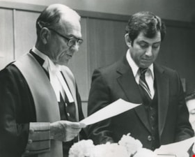
Justice G. L. Murray swearing in Mayor Dave Mercier
https://search.heritageburnaby.ca/link/archivedescription46289
- Repository
- City of Burnaby Archives
- Date
- March 11, 1980
- Collection/Fonds
- Columbian Newspaper collection
- Description Level
- Item
- Physical Description
- 1 photograph : b&w ; 19 x 24 cm
- Scope and Content
- Photograph of Justice G. L. Murray administrating the oath of office to Mayor Dave Mercier. Dave Mercier was a council member from 1968 to 1971, and from 1977 to 1981, serving as Mayor from 1979 to 1981.
- Repository
- City of Burnaby Archives
- Date
- March 11, 1980
- Collection/Fonds
- Columbian Newspaper collection
- Physical Description
- 1 photograph : b&w ; 19 x 24 cm
- Description Level
- Item
- Record No.
- 480-1177
- Access Restriction
- No restrictions
- Reproduction Restriction
- No restrictions
- Accession Number
- 2003-02
- Scope and Content
- Photograph of Justice G. L. Murray administrating the oath of office to Mayor Dave Mercier. Dave Mercier was a council member from 1968 to 1971, and from 1977 to 1981, serving as Mayor from 1979 to 1981.
- Media Type
- Photograph
- Photographer
- King, Basil
- Notes
- Title based on contents of photograph
- Geographic Access
- Canada Way
- Street Address
- 4949 Canada Way
- Historic Neighbourhood
- Burnaby Lake (Historic Neighbourhood)
- Planning Study Area
- Douglas-Gilpin Area
Images

![Framed panel of weapons and firing stances used in firearms training, [198-] thumbnail](/media/hpo/_Data/_BVM_Images/1991/1991_0045_0044_002.jpg?width=280)
Framed panel of weapons and firing stances used in firearms training
https://search.heritageburnaby.ca/link/museumdescription1115
- Repository
- Burnaby Village Museum
- Date
- [198-]
- Collection/Fonds
- Oakalla Prison collection
- Description Level
- Item
- Physical Description
- 1 photograph (tiff) ; 240 dpi
- Scope and Content
- Item consists of a documentation photograph of a framed panel of fourteen photographs of an unidentified correctional officer demonstrating weapon and firing stances used in firearms training. Photographs within panel are arranged in three rows with various positions of stances identified under eac…
- Repository
- Burnaby Village Museum
- Collection/Fonds
- Oakalla Prison collection
- Description Level
- Item
- Physical Description
- 1 photograph (tiff) ; 240 dpi
- Scope and Content
- Item consists of a documentation photograph of a framed panel of fourteen photographs of an unidentified correctional officer demonstrating weapon and firing stances used in firearms training. Photographs within panel are arranged in three rows with various positions of stances identified under each (from left to right, top row) "Port Arms"; "Easy Ready" ; "Kneeling"; "Standing"; "Hip"; (from left to right middle row) "Easy Ready"; "Standing"; "Unloading"; "Instinctive "Chest""; "Instinctive Hip"; (from left to right bottom row)"Kneeling Tradional"; "Kneeling Variation"; "Kneeling Variation"; "Sitting".
- Geographic Access
- Oakmount Crescent
- Street Address
- 5220 Oakmount Crescent
- Accession Code
- BV991.45.44
- Access Restriction
- No restrictions
- Reproduction Restriction
- May be restricted by third party rights
- Date
- [198-]
- Media Type
- Photograph
- Historic Neighbourhood
- Burnaby Lake (Historic Neighbourhood)
- Planning Study Area
- Oakalla Area
- Notes
- Title based on contents of photograph
- Panel with 14 photographs was originally enclosed within a thin wood frame with glass (60 x 74 cm) with photographs adhered to a blue sheet of poster board (56.2 x 70.8 cm - poster board was extremely faded; original colour can be seen as residue on backs of photographs); 14 colour photographs : 8.89 x 12.7 cm. Frame, glass and poster board disposed of due to poor condition. A reference photograph was created prior to destruction of frame and dismantling of photographs on board.
- Individual photographs were removed from board and described at item level BV991.45.595 to .BV991.45.606
Images
![Framed panel of weapons and firing stances used in firearms training, [198-] thumbnail](/media/hpo/_Data/_BVM_Images/1991/1991_0045_0044_002.jpg)
![Back gate entrance to east wing kitchen of Oakalla, [198-] thumbnail](/media/hpo/_Data/_BVM_Images/1991/1991_0045_0275_001.jpg?width=280)
Back gate entrance to east wing kitchen of Oakalla
https://search.heritageburnaby.ca/link/museumdescription1116
- Repository
- Burnaby Village Museum
- Date
- [198-]
- Collection/Fonds
- Oakalla Prison collection
- Description Level
- Item
- Physical Description
- 1 photgraph : b&w ; 12.5 x 13 cm
- Scope and Content
- Photograph of back gate entrance to east wing kitchen of Oakalla Prison. A tall chain link gate stands at the entrance in front of a one storey brick building.
- Repository
- Burnaby Village Museum
- Collection/Fonds
- Oakalla Prison collection
- Description Level
- Item
- Physical Description
- 1 photgraph : b&w ; 12.5 x 13 cm
- Scope and Content
- Photograph of back gate entrance to east wing kitchen of Oakalla Prison. A tall chain link gate stands at the entrance in front of a one storey brick building.
- History
- Salvaged from Oakalla Prison Farm site in October 1991
- Subjects
- Public Services - Correctional
- Geographic Access
- Oakmount Crescent
- Street Address
- 5220 Oakmount Crescent
- Accession Code
- BV991.45.275
- Access Restriction
- No restrictions
- Reproduction Restriction
- May be restricted by third party rights
- Date
- [198-]
- Media Type
- Photograph
- Historic Neighbourhood
- Burnaby Lake (Historic Neighbourhood)
- Planning Study Area
- Oakalla Area
- Scan Resolution
- 600
- Scan Date
- June 7, 2021
- Scale
- 100
- Notes
- Title based on contents of photograph
- Note in blue ink on verso of photograph reads: "BACK GATE ENTRANCE / TO EAST WING KITCHEN"
- Photograph was stapled to sheet of white looseleaf paper, three holes on left side and removed
Images
![Back gate entrance to east wing kitchen of Oakalla, [198-] thumbnail](/media/hpo/_Data/_BVM_Images/1991/1991_0045_0275_001.jpg)
Oakalla prison staff 4192
https://search.heritageburnaby.ca/link/museumdescription1117
- Repository
- Burnaby Village Museum
- Date
- [198-]
- Collection/Fonds
- Oakalla Prison collection
- Description Level
- Item
- Physical Description
- 1 photograph : b&w ; 4.5 x 5 cm
- Scope and Content
- Photograph of an unidentified staff member of Oakalla Prison. Photograph may have been used to identification purposes. Staff member appears to be female with short hair, dressed in dark jacket and white shirt with the numbers "4192" displayed below (bottom half of numbers are not visible).
- Repository
- Burnaby Village Museum
- Collection/Fonds
- Oakalla Prison collection
- Description Level
- Item
- Physical Description
- 1 photograph : b&w ; 4.5 x 5 cm
- Scope and Content
- Photograph of an unidentified staff member of Oakalla Prison. Photograph may have been used to identification purposes. Staff member appears to be female with short hair, dressed in dark jacket and white shirt with the numbers "4192" displayed below (bottom half of numbers are not visible).
- History
- Salvaged from Oakalla Prison Farm site in October 1991
- Subjects
- Public Services - Correctional
- Geographic Access
- Oakmount Crescent
- Street Address
- 5220 Oakmount Crescent
- Accession Code
- BV991.45.416
- Access Restriction
- Restricted access
- Reproduction Restriction
- May be restricted by third party rights
- Date
- [198-]
- Media Type
- Photograph
- Historic Neighbourhood
- Burnaby Lake (Historic Neighbourhood)
- Planning Study Area
- Oakalla Area
- Scan Resolution
- 1000
- Scan Date
- June 7, 2021
- Scale
- 100
- Notes
- Title based on contents of photograph
![Oakalla Prison Farm buildings and grounds, [198-] thumbnail](/media/hpo/_Data/_BVM_Images/1991/1991_0045_0505_001.jpg?width=280)
Oakalla Prison Farm buildings and grounds
https://search.heritageburnaby.ca/link/museumdescription3126
- Repository
- Burnaby Village Museum
- Date
- [198-]
- Collection/Fonds
- Oakalla Prison collection
- Description Level
- Item
- Physical Description
- 1 photograph : b&w negative ; 10 x 12.5 cm
- Scope and Content
- Photograph of the grounds and buildings of Oakalla Prison Farm looking north towards Deer Lake. An open field is visible in the foreground with a barn and other other farm buildings located down the slope towards the lake.
- Repository
- Burnaby Village Museum
- Collection/Fonds
- Oakalla Prison collection
- Description Level
- Item
- Physical Description
- 1 photograph : b&w negative ; 10 x 12.5 cm
- Scope and Content
- Photograph of the grounds and buildings of Oakalla Prison Farm looking north towards Deer Lake. An open field is visible in the foreground with a barn and other other farm buildings located down the slope towards the lake.
- History
- Salvaged from Oakalla Prison Farm site in October, 1991
- Subjects
- Public Services - Correctional
- Geographic Access
- Oakmount Crescent
- Street Address
- 5220 Oakmount Crescent
- Accession Code
- BV991.45.505
- Access Restriction
- No restrictions
- Reproduction Restriction
- May be restricted by third party rights
- Date
- [198-]
- Media Type
- Photograph
- Historic Neighbourhood
- Burnaby Lake (Historic Neighbourhood)
- Planning Study Area
- Oakalla Area
- Scan Resolution
- 1200
- Scan Date
- 2022-01-10
- Notes
- Title based on contents of photograph
Images
![Oakalla Prison Farm buildings and grounds, [198-] thumbnail](/media/hpo/_Data/_BVM_Images/1991/1991_0045_0505_001.jpg)
![Antique cars on Hill Street, [198-] thumbnail](/media/hpo/_Data/_BVM_Images/2020/2020_0005_0934_001.jpg?width=280)
Antique cars on Hill Street
https://search.heritageburnaby.ca/link/museumdescription13743
- Repository
- Burnaby Village Museum
- Date
- [198-]
- Collection/Fonds
- Century Park Museum Association fonds
- Description Level
- Item
- Physical Description
- 1 photograph : col. ; 10 x 15 cm
- Scope and Content
- Photograph of Hill Street inside Heritage Village Museum. Visitors are gathered along the street to view antique cars and buildings are decorated with red, white and blue bunting.
- Repository
- Burnaby Village Museum
- Collection/Fonds
- Century Park Museum Association fonds
- Description Level
- Item
- Physical Description
- 1 photograph : col. ; 10 x 15 cm
- Scope and Content
- Photograph of Hill Street inside Heritage Village Museum. Visitors are gathered along the street to view antique cars and buildings are decorated with red, white and blue bunting.
- Names
- Burnaby Village Museum
- Geographic Access
- Deer Lake Avenue
- Accession Code
- BV020.5.934
- Access Restriction
- No restrictions
- Reproduction Restriction
- No known restrictions
- Date
- [198-]
- Media Type
- Photograph
- Historic Neighbourhood
- Burnaby Lake (Historic Neighbourhood)
- Planning Study Area
- Morley-Buckingham Area
- Scan Resolution
- 600
- Scan Date
- 22-Sep-2020
- Scale
- 100
- Notes
- Title based on contents of photograph
Images
![Antique cars on Hill Street, [198-] thumbnail](/media/hpo/_Data/_BVM_Images/2020/2020_0005_0934_001.jpg)
Oakalla prison correctional officer 4214
https://search.heritageburnaby.ca/link/museumdescription16688
- Repository
- Burnaby Village Museum
- Date
- [198-]
- Collection/Fonds
- Oakalla Prison collection
- Description Level
- Item
- Physical Description
- 1 photograph : b&w ; 4.5 x 5 cm
- Scope and Content
- Photograph of an unidentified correctional officer of Oakalla Prison. Photograph may have been used to identification purposes. Officer has short hair and mustache, dressed in uniform with the numbers "4214" displayed below.
- Repository
- Burnaby Village Museum
- Collection/Fonds
- Oakalla Prison collection
- Description Level
- Item
- Physical Description
- 1 photograph : b&w ; 4.5 x 5 cm
- Scope and Content
- Photograph of an unidentified correctional officer of Oakalla Prison. Photograph may have been used to identification purposes. Officer has short hair and mustache, dressed in uniform with the numbers "4214" displayed below.
- History
- Salvaged from Oakalla Prison Farm site in October 1991
- Subjects
- Public Services - Correctional
- Geographic Access
- Oakmount Crescent
- Street Address
- 5220 Oakmount Crescent
- Accession Code
- BV991.45.417
- Access Restriction
- Restricted access
- Reproduction Restriction
- May be restricted by third party rights
- Date
- [198-]
- Media Type
- Photograph
- Historic Neighbourhood
- Burnaby Lake (Historic Neighbourhood)
- Planning Study Area
- Oakalla Area
- Scan Resolution
- 1000
- Scan Date
- June 7, 2021
- Scale
- 100
- Notes
- Title based on contents of photograph
- Note in pencil on verso of photograph reads: "Pohl"