Pond in front of the Baldwin house
https://search.heritageburnaby.ca/link/archivedescription37349
- Repository
- City of Burnaby Archives
- Date
- 1966
- Collection/Fonds
- Burnaby Historical Society fonds
- Description Level
- Item
- Physical Description
- 1 photograph : b&w ; 19 x 25.5 cm
- Scope and Content
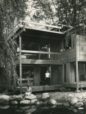
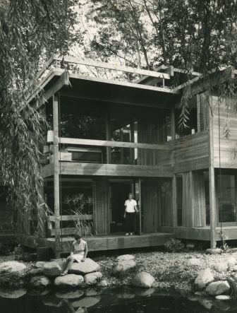
- Photograph of two women, one standing in the doorway and another seated on a rock at the edge of the water, outside the Dr. William and Ruth Baldwin House at Deer Lake. A note on the back of the photograph indicates that one of the women may be Susan Baldwin.
- Repository
- City of Burnaby Archives
- Date
- 1966
- Collection/Fonds
- Burnaby Historical Society fonds
- Subseries
- Baldwin family subseries
- Physical Description
- 1 photograph : b&w ; 19 x 25.5 cm
- Description Level
- Item
- Record No.
- 357-004
- Access Restriction
- No restrictions
- Reproduction Restriction
- Reproduce for fair dealing purposes only
- Accession Number
- BHS1998-03
- Scope and Content
- Photograph of two women, one standing in the doorway and another seated on a rock at the edge of the water, outside the Dr. William and Ruth Baldwin House at Deer Lake. A note on the back of the photograph indicates that one of the women may be Susan Baldwin.
- Names
- Baldwin, Susan
- Media Type
- Photograph
- Photographer
- King, Basil
- Notes
- Title based on contents of photograph.
- This photograph is the same as item no. 357-006
- Geographic Access
- Deer Lake Drive
- Street Address
- 6543 Deer Lake Drive
- Historic Neighbourhood
- Burnaby Lake (Historic Neighbourhood)
- Planning Study Area
- Morley-Buckingham Area
Images
Sailboats on Deer Lake
https://search.heritageburnaby.ca/link/archivedescription58902
- Repository
- City of Burnaby Archives
- Date
- ca.1965
- Collection/Fonds
- Columbian Newspaper collection
- Description Level
- Item
- Physical Description
- 1 photograph : b&w ; 19.5 x 20.5 cm
- Scope and Content
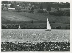
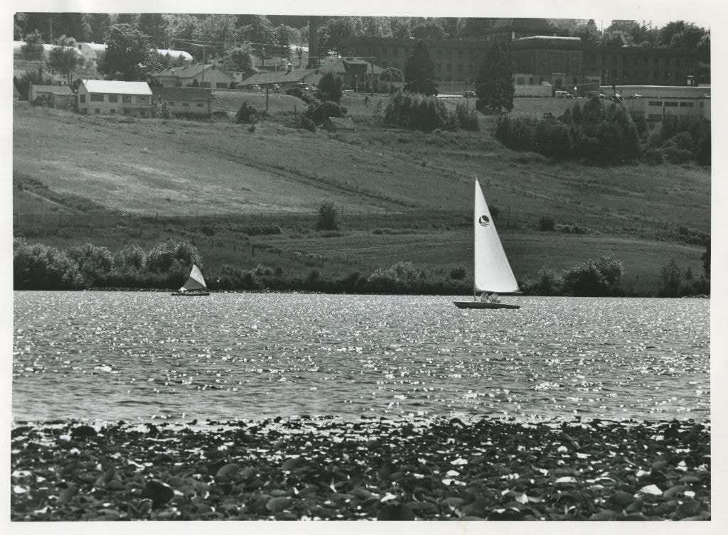
- Photograph of sailboats on Deer Lake. Oakalla Prison Farm is visible on the hill in the background.
- Repository
- City of Burnaby Archives
- Date
- ca.1965
- Collection/Fonds
- Columbian Newspaper collection
- Physical Description
- 1 photograph : b&w ; 19.5 x 20.5 cm
- Description Level
- Item
- Record No.
- 480-1359
- Access Restriction
- No restrictions
- Reproduction Restriction
- May be restricted by third party rights
- Accession Number
- 2009-01
- Scope and Content
- Photograph of sailboats on Deer Lake. Oakalla Prison Farm is visible on the hill in the background.
- Subjects
- Recreational Activities - Boating
- Names
- Oakalla Prison Farm
- Media Type
- Photograph
- Photographer
- Battistoni, Peter
- Notes
- Title based on contents of photograph
- Photographer's stamp on verso
- Note on verso reads: "PMT 100% / page 12 / Burnaby Today"
- Geographic Access
- Deer Lake
- Historic Neighbourhood
- Burnaby Lake (Historic Neighbourhood)
- Planning Study Area
- Oakalla Area
Images
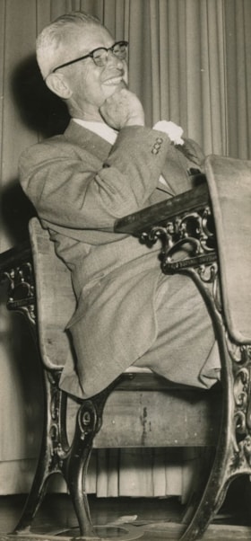
School Principal Burwell Brown
https://search.heritageburnaby.ca/link/archivedescription45177
- Repository
- City of Burnaby Archives
- Date
- 1960, published June 4, 1960
- Collection/Fonds
- Columbian Newspaper collection
- Description Level
- Item
- Physical Description
- 1 photograph : b&w ; 20 x 9.5 cm
- Scope and Content
- Photograph of Burwell Brown, Cascade Heights Elementary School Principal, taken the night of his retirement party at Burnaby Central High School. He is sitting in the "prisoner's box" at a mock trial that found him guilty of being an outstanding principal and teacher in Burnaby. He was the principa…
- Repository
- City of Burnaby Archives
- Date
- 1960, published June 4, 1960
- Collection/Fonds
- Columbian Newspaper collection
- Physical Description
- 1 photograph : b&w ; 20 x 9.5 cm
- Description Level
- Item
- Record No.
- 480-073
- Access Restriction
- No restrictions
- Reproduction Restriction
- Reproduce for fair dealing purposes only
- Accession Number
- 2003-02
- Scope and Content
- Photograph of Burwell Brown, Cascade Heights Elementary School Principal, taken the night of his retirement party at Burnaby Central High School. He is sitting in the "prisoner's box" at a mock trial that found him guilty of being an outstanding principal and teacher in Burnaby. He was the principal of Schou Street School from 1927 to 1953, before taking the same position at Cascade Heights Elementary School.
- Names
- Brown, Burwell
- Burnaby Central Secondary School
- Schou Street School
- Cascade Heights Elementary School
- Media Type
- Photograph
- Notes
- Title based on contents of photograph
- Geographic Access
- Canada Way
- Street Address
- 4939 Canada Way
- Historic Neighbourhood
- Burnaby Lake (Historic Neighbourhood)
- Planning Study Area
- Douglas-Gilpin Area
Images

![Sleigh ride, [between 1890 and 1909] thumbnail](/media/hpo/_Data/_BVM_Images/2000/200300610001.jpg?width=280)
Sleigh ride
https://search.heritageburnaby.ca/link/museumdescription1675
- Repository
- Burnaby Village Museum
- Date
- [between 1890 and 1909]
- Collection/Fonds
- Burnaby Village Museum Photograph collection
- Description Level
- Item
- Physical Description
- 1 photograph : sepia ; 5 x 7.5 cm, mounted on card 10 x 12.5 cm
- Scope and Content
- Photograph of an unidentified man and woman riding through the snow on a horse-drawn sleigh on Park Row in New Westminster.
- Repository
- Burnaby Village Museum
- Collection/Fonds
- Burnaby Village Museum Photograph collection
- Description Level
- Item
- Physical Description
- 1 photograph : sepia ; 5 x 7.5 cm, mounted on card 10 x 12.5 cm
- Scope and Content
- Photograph of an unidentified man and woman riding through the snow on a horse-drawn sleigh on Park Row in New Westminster.
- Geographic Access
- Burnaby Lake
- Accession Code
- BV003.61.1
- Access Restriction
- No restrictions
- Date
- [between 1890 and 1909]
- Media Type
- Photograph
- Historic Neighbourhood
- Burnaby Lake (Historic Neighbourhood)
- Planning Study Area
- Burnaby Lake Area
- Scan Resolution
- 600
- Scan Date
- 09-Jun-09
- Scale
- 100
- Notes
- Title based on contents of photograph
- Note in pencil on verso of card mount reads: "NEAR BURNABY LAKE,/ Burnaby, B.C."
Images
![Sleigh ride, [between 1890 and 1909] thumbnail](/media/hpo/_Data/_BVM_Images/2000/200300610001.jpg)
![Subdivision plans in New Westminster District Group 1 – Burnaby
, [1893-1910] thumbnail](/media/hpo/_Data/_BVM_Cartographic_Material/1977/1977_0093_0016a_001.jpg?width=280)
Subdivision plans in New Westminster District Group 1 – Burnaby
https://search.heritageburnaby.ca/link/museumdescription6985
- Repository
- Burnaby Village Museum
- Date
- [1893-1910]
- Collection/Fonds
- Burnaby Village Museum Map collection
- Description Level
- File
- Physical Description
- 4 plans : blueprint ink on paper mounted on 2 sides of cardboard 76 x 102 cm
- Scope and Content
- Item consists of a large board of two New Westminster District Gp 1 - subdivision plans mounted on one side and two New Westminster District Gp 1 - subdivision plans mounted on the other side. Side A: 1. Blueprint "Plan / of Subdivision / of / Lot 6 / Group One / New Westminster District / Scale…
- Repository
- Burnaby Village Museum
- Collection/Fonds
- Burnaby Village Museum Map collection
- Description Level
- File
- Physical Description
- 4 plans : blueprint ink on paper mounted on 2 sides of cardboard 76 x 102 cm
- Material Details
- Scales [between 1:1584 and 1:3960]
- Index number on edge of board reads: "16"
- Scope and Content
- Item consists of a large board of two New Westminster District Gp 1 - subdivision plans mounted on one side and two New Westminster District Gp 1 - subdivision plans mounted on the other side. Side A: 1. Blueprint "Plan / of Subdivision / of / Lot 6 / Group One / New Westminster District / Scale 5 chs = 1 in. / Map No 748" (Geographic location: Burnaby) 2. Blueprint "Plan / of Subdivision / of a Portion / of / Lot 29 / Group One / New Westminster Dist. / Scale 2 chs = 1 in. / Map No." Name identified in Block H is "Reichenbach" (Geographic location: Burnaby) Side B: 1. Blueprint "Plan / of Subdivision / of North 1/2 of Lot 80 / Group One / New Westminster District / Scale 3 chs = 1 in. / Map No 719" Plan is signed by: "Garden, Hermon & Burwell P.L.S. / Vancouver Jan. 23rd, 1893" (Geographic location: Burnaby) 2. Blueprint "Plan / of Subdivision / of Lot 79, Gr.1 / New Westminster Dist. / Scale 4 chas = 1 in. / Map No 536" Plan is signed by "Garden Hermon & Burwell / Provincial Land Surveyors". (Geographic location: Burnaby)
- Creator
- Garden, Hermon and Burwell
- Accession Code
- HV977.93.16
- Access Restriction
- No restrictions
- Reproduction Restriction
- No known restrictions
- Date
- [1893-1910]
- Media Type
- Cartographic Material
- Historic Neighbourhood
- Edmonds (Historic Neighbourhood)
- Burnaby Lake (Historic Neighbourhood)
- Planning Study Area
- Douglas-Gilpin Area
- Edmonds Area
- Cameron Area
- Scan Resolution
- 300
- Scale
- 72
- Notes
- Title based on contents of file
- Scale is measured in chains. (One chain equals 792 inches)
- The term "Lot" can also refer to a "District Lot”
Images
![Subdivision plans in New Westminster District Group 1 – Burnaby
, [1893-1910] thumbnail](/media/hpo/_Data/_BVM_Cartographic_Material/1977/1977_0093_0016a_001.jpg)

![Survey and Subdivision plans in New Westminster District Group 1 – Burnaby, Port Moody, [1862-1908] thumbnail](/media/hpo/_Data/_BVM_Cartographic_Material/1977/1977_0093_0026a_001.jpg?width=280)
Survey and Subdivision plans in New Westminster District Group 1 – Burnaby, Port Moody
https://search.heritageburnaby.ca/link/museumdescription6995
- Repository
- Burnaby Village Museum
- Date
- [1862-1908]
- Collection/Fonds
- Burnaby Village Museum Map collection
- Description Level
- File
- Physical Description
- 9 plans : 6 plans : black ink on paper ; 57 x 36.5 cm or smaller + 1 plan : black ink and grahite on paper ; 46.5 x 49 cm + 1 plan : blueprint on paper ; 15.5 x 19.5 cm + cm + 1 plan : graphite on paper ; 25 x 17 cm ; mounted on both sides of board 76 x 102 cm
- Scope and Content
- Item consists of a large board of four New Westminster District subdivision plans mounted on one side and five New Westminster District subdivision plans mounted on the other side. Side A: 1. "Plan / of Subdivision / of a Portion / of / Lot 87 / Group One / New Westminster District / Scale 4 chs…
- Repository
- Burnaby Village Museum
- Collection/Fonds
- Burnaby Village Museum Map collection
- Description Level
- File
- Physical Description
- 9 plans : 6 plans : black ink on paper ; 57 x 36.5 cm or smaller + 1 plan : black ink and grahite on paper ; 46.5 x 49 cm + 1 plan : blueprint on paper ; 15.5 x 19.5 cm + cm + 1 plan : graphite on paper ; 25 x 17 cm ; mounted on both sides of board 76 x 102 cm
- Material Details
- Scales [between 1:792 and 1:3600]
- Index number on edge of board reads: "26"
- Scope and Content
- Item consists of a large board of four New Westminster District subdivision plans mounted on one side and five New Westminster District subdivision plans mounted on the other side. Side A: 1. "Plan / of Subdivision / of a Portion / of / Lot 87 / Group One / New Westminster District / Scale 4 chs = 1 in". Plan is stamped: "Albert J. Hill, Civil Engineer / and / Provincial Land Surveyor, / New Westminster, / B.C." and intialed by: "RB" [sic] (in blue pencil crayon). Names two of the subdivisons of District Lot 87 are identified as, "L.E. Sprott" and "John Ledger". (Geographic location: Burnaby) 2. "Plan of Subdivision / of / Portions of / Lot 136, 131 and Lots 44 and 78 Gr.1 / New Westminster District / Scale 300 ft = 1 inch". Annotation above title reads: "No. 901 / Deposited in Land Registry Office / New Westminster / Aug. 19th 1905 / Charles S. Keith D. Reg." Annotations and signatures at bottom of plan read: "I, William Nelson Draper, / W.H.R. Collister / Charles E. Perkins / E.B. Morgan / make / Surveys / correct / representation / upon / the / Land Registry Act / (sgd) W.N. Draper, P.L.S.". Plan includes a handwritten title: "Lots 136, 131, 44 & 78" and is initialed: "RB" [sic] (in blue pencil crayon) (Geographic location: Burnaby) 3. "Survey / of / a Portion / of / Lot 95, Gr.1 / Scale 1 ch = 1in." Plan is stamped: "Albert J. Hill, Civil Engineer / and / Provincial Land Surveyor, / New Westminster, / B.C." and is initialed : "RB" [sic] (in blue pencil crayon) (Geographic location: Burnaby) 4. Blueprint plan of "Lot 396. Group One." with Scale : 3 chs = 1 in. A two acre portion of District Lot 396 is filled in with red ink." Plan is signed by "Albert J. Hill / B.C.L.S." (Geographic location: Port Moody) Side B: 1. Plan titled "District Lot 92 / Burnaby / Municipality / for sale by / Mahon / McFarland & / Mahon Ltd. / Vancouver, B.C. / Scale : 4 chains to one inch". District Lot 92 is subdivided into 161 lots and identifies roads: Norwich Road, Pole Line Road, Oakland Road, Stanley Road, Burford Road, Dalhousie Road, Brantford Road, Colborne Road, Roberts Road, Vancouver & Westminster Road, B.C. Electric Railway, Gilley Stn. and Burnaby (Power House). The bottom of the plan reads: "G.S. Dawson, P.LS. Vancouver, B.C." (Geographic location: Burnaby) 2. "Plan / of Subdivision / of a Portion / of / Lot 29 / Group 1 / New Westminster District / Scale 2 chs = 1 in". Plan is stamped: "Albert J. Hill, Civil Engineer / and / Provincial Land Surveyor, / New Westminster, / B.C." and is initialed by: "RB" [sic] (in blue pencil crayon) (Geographic location: Burnaby) 3. Small handrawn plan (no title) identifying "Lot 84 / Hydes, Claim" at the centre surrounded by lots and features identified as: "Lot 85", "Lot 93", "Lot 94", "Lot 32", "Lot 82", "Lot 83", "Lot 79", "swamp" and a "Small Lake" (Burnaby Lake). Identifying marks in the right corner of the plan read: "Page 13 / Surveyed by G. Turner / May 62". Plan also includes surveyor's bearing measurements and trails to "Small Lake" (Burnaby Lake). (Geographic location: Burnaby) 4. Untitled plan showing District Lots west of North Road and north of Burnaby Lake including: Lots 2, 4, 6, 8, 15, 10, 56, 148, 57, 58, 40. and Lots 3, 5, 7 east of North Road (Coquitlam). Lots in Burnaby are identifed for timber including: "Heavily Timbered" (Lot 57), " "Some Fir and Cedar" (Lot 40), "Splendid Fir and Cedar" (Lot 143), "Heavy Fir etc" (Lots 143 and 148), " "Fine Cedar" (Lot 15), "Rough Light Timber" (Lot 56). Other features identified at the lower portion of the plan include "Burnaby Lake" and "Brunette River". (Geographic location: Burnaby) 5. Untitled plan drawn in graphite showing sections of District Lot 85 south of Burnaby Lake and north of Hazsard Road. Plan is signed: "Albert J. Hill / B.C.L.S." and dated "12/26/08". Plan is initialed by: "RB" [sic] (in blue pencil crayon) (Geographic location: Burnaby)
- Publisher
- Mahon, McFarland & Mahon Ltd
- Accession Code
- HV977.93.26
- Access Restriction
- No restrictions
- Reproduction Restriction
- No known restrictions
- Date
- [1862-1908]
- Media Type
- Cartographic Material
- Historic Neighbourhood
- Burnaby Lake (Historic Neighbourhood)
- Burquitlam (Historic Neighbourhood)
- Planning Study Area
- Burnaby Lake Area
- Scan Resolution
- 300
- Scale
- 72
- Notes
- Title based on contents of file
- Scale is measured in chains and feet. (One chain equals 792 inches)
- The term "Lot" can also refer to a "District Lot”
Images
![Survey and Subdivision plans in New Westminster District Group 1 – Burnaby, Port Moody, [1862-1908] thumbnail](/media/hpo/_Data/_BVM_Cartographic_Material/1977/1977_0093_0026a_001.jpg)


![Tea at the Kincaid house, [196-] (date of original), copied 1995 thumbnail](/media/Hpo/_Data/_Archives_Images/_Unrestricted/316/324-002.jpg?width=280)
Tea at the Kincaid house
https://search.heritageburnaby.ca/link/archivedescription37125
- Repository
- City of Burnaby Archives
- Date
- [196-] (date of original), copied 1995
- Collection/Fonds
- Burnaby Historical Society fonds
- Description Level
- Item
- Physical Description
- 1 photograph : b&w ; 8.5 x 12.5 cm print
- Scope and Content
- Photograph of three people sitting outside on lawn chairs having tea together at the Kincaid house on Glencarin Drive. There is a dog and a tricycle on the lawn.
- Repository
- City of Burnaby Archives
- Date
- [196-] (date of original), copied 1995
- Collection/Fonds
- Burnaby Historical Society fonds
- Subseries
- Photographs subseries
- Physical Description
- 1 photograph : b&w ; 8.5 x 12.5 cm print
- Description Level
- Item
- Record No.
- 324-002
- Access Restriction
- No restrictions
- Reproduction Restriction
- Reproduce for fair dealing purposes only
- Accession Number
- BHS1995-18
- Scope and Content
- Photograph of three people sitting outside on lawn chairs having tea together at the Kincaid house on Glencarin Drive. There is a dog and a tricycle on the lawn.
- Media Type
- Photograph
- Notes
- Title based on contents of photograph
- Geographic Access
- Glencarin Drive
- Historic Neighbourhood
- Burnaby Lake (Historic Neighbourhood)
- Planning Study Area
- Burnaby Lake Area
Images
![Tea at the Kincaid house, [196-] (date of original), copied 1995 thumbnail](/media/Hpo/_Data/_Archives_Images/_Unrestricted/316/324-002.jpg)
![Tea at the Kincaid house, [196-] (date of original), copied 1995 thumbnail](/media/Hpo/_Data/_Archives_Images/_Unrestricted/316/324-003.jpg?width=280)
Tea at the Kincaid house
https://search.heritageburnaby.ca/link/archivedescription37126
- Repository
- City of Burnaby Archives
- Date
- [196-] (date of original), copied 1995
- Collection/Fonds
- Burnaby Historical Society fonds
- Description Level
- Item
- Physical Description
- 1 photograph : b&w ; 8.5 x 12.5 cm print
- Scope and Content
- Photograph of three people sitting outside on lawn chairs having tea together at the Kincaid house on Glencarin Drive.
- Repository
- City of Burnaby Archives
- Date
- [196-] (date of original), copied 1995
- Collection/Fonds
- Burnaby Historical Society fonds
- Subseries
- Photographs subseries
- Physical Description
- 1 photograph : b&w ; 8.5 x 12.5 cm print
- Description Level
- Item
- Record No.
- 324-003
- Access Restriction
- No restrictions
- Reproduction Restriction
- Reproduce for fair dealing purposes only
- Accession Number
- BHS1995-18
- Scope and Content
- Photograph of three people sitting outside on lawn chairs having tea together at the Kincaid house on Glencarin Drive.
- Subjects
- Buildings - Residential - Houses
- Media Type
- Photograph
- Notes
- Title based on contents of photograph
- Geographic Access
- Glencarin Drive
- Historic Neighbourhood
- Burnaby Lake (Historic Neighbourhood)
- Planning Study Area
- Burnaby Lake Area
Images
![Tea at the Kincaid house, [196-] (date of original), copied 1995 thumbnail](/media/Hpo/_Data/_Archives_Images/_Unrestricted/316/324-003.jpg)
![Tom Cornforth measuring peas, [196-] (date of original), copied 1992 thumbnail](/media/hpo/_Data/_Archives_Images/_Unrestricted/315/315-264.jpg?width=280)
Tom Cornforth measuring peas
https://search.heritageburnaby.ca/link/archivedescription36806
- Repository
- City of Burnaby Archives
- Date
- [196-] (date of original), copied 1992
- Collection/Fonds
- Burnaby Historical Society fonds
- Description Level
- Item
- Physical Description
- 1 photograph : b&w ; 8.7 x 10.5 cm print
- Scope and Content
- Photograph of Tom Cornforth measuring the pea plants in the garden at his house on Royal Oak Avenue.
- Repository
- City of Burnaby Archives
- Date
- [196-] (date of original), copied 1992
- Collection/Fonds
- Burnaby Historical Society fonds
- Subseries
- Burnaby Centennial Anthology subseries
- Physical Description
- 1 photograph : b&w ; 8.7 x 10.5 cm print
- Description Level
- Item
- Record No.
- 315-264
- Access Restriction
- No restrictions
- Reproduction Restriction
- Reproduce for fair dealing purposes only
- Accession Number
- BHS1994-04
- Scope and Content
- Photograph of Tom Cornforth measuring the pea plants in the garden at his house on Royal Oak Avenue.
- Subjects
- Geographic Features - Gardens
- Names
- Cornforth, Tom
- Media Type
- Photograph
- Notes
- Title based on contents of photograph
- Geographic Access
- Royal Oak Avenue
- Historic Neighbourhood
- Burnaby Lake (Historic Neighbourhood)
- Planning Study Area
- Douglas-Gilpin Area
Images
![Tom Cornforth measuring peas, [196-] (date of original), copied 1992 thumbnail](/media/hpo/_Data/_Archives_Images/_Unrestricted/315/315-264.jpg)
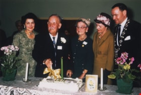
Tom Irvine on his one hundredth birthday
https://search.heritageburnaby.ca/link/museumdescription1867
- Repository
- Burnaby Village Museum
- Date
- March 7, 1964
- Collection/Fonds
- Century Park Museum Association fonds
- Description Level
- Item
- Physical Description
- 1 photograph : col. ; 9 x 13.5 cm
- Scope and Content
- Photograph of (from left); Olive Procter, Tom Irvine, Mrs. H. Clarke, Mrs. Emmott and Reeve Alan Emmott at Tom Irvine's one hundredth birthday celebration at Deer Lake United Church. Tom Irvine was a member of the Deer Lake Golden Age Club.
- Repository
- Burnaby Village Museum
- Collection/Fonds
- Century Park Museum Association fonds
- Description Level
- Item
- Physical Description
- 1 photograph : col. ; 9 x 13.5 cm
- Material Details
- .
- Scope and Content
- Photograph of (from left); Olive Procter, Tom Irvine, Mrs. H. Clarke, Mrs. Emmott and Reeve Alan Emmott at Tom Irvine's one hundredth birthday celebration at Deer Lake United Church. Tom Irvine was a member of the Deer Lake Golden Age Club.
- Subjects
- Celebrations
- Names
- Irvine, Tom
- Proctor, Olive
- Clarke, Mrs. H.
- Emmott, Alan H.
- Emmott, Mrs.
- Deer Lake United Church
- Geographic Access
- Sperling Avenue
- Street Address
- 5135 Sperling Avenue
- Accession Code
- BV005.14.20
- Access Restriction
- Restricted access
- Reproduction Restriction
- May be restricted by third party rights
- Date
- March 7, 1964
- Media Type
- Photograph
- Historic Neighbourhood
- Burnaby Lake (Historic Neighbourhood)
- Planning Study Area
- Morley-Buckingham Area
- Scan Resolution
- 600
- Scan Date
- 11-Jun-09
- Scale
- 100
- Notes
- Title based on contents of photograph
- Note in black ink on verso of photograph reads: "(Left to right) Olive Procter, Tom Irvine, Mrs. H. Clarke, Mrs Emmott, Reeve Alan Emmott. Taken at Deer Lake United Church - on Tom's 100th birthday March 7, 1964. He was a member of the Deer Lake Golden Age Club."
Images

![Top floor of the Burnaby Art Gallery, [between 1960 and 1969] thumbnail](/media/hpo/_Data/_Archives_Images/_Unrestricted/205/242-011.jpg?width=280)
Top floor of the Burnaby Art Gallery
https://search.heritageburnaby.ca/link/archivedescription36261
- Repository
- City of Burnaby Archives
- Date
- [between 1960 and 1969]
- Collection/Fonds
- Burnaby Historical Society fonds
- Description Level
- Item
- Physical Description
- 1 photograph : b&w ; 19 x 19 cm
- Scope and Content
- Photograph of the top floor of the Burnaby Art Gallery. There is a wooden railing on the right and artwork hung salon-style on the wall on the left.
- Repository
- City of Burnaby Archives
- Date
- [between 1960 and 1969]
- Collection/Fonds
- Burnaby Historical Society fonds
- Subseries
- Burnaby Art Gallery subseries
- Physical Description
- 1 photograph : b&w ; 19 x 19 cm
- Description Level
- Item
- Record No.
- 242-011
- Access Restriction
- No restrictions
- Reproduction Restriction
- Reproduce for fair dealing purposes only
- Accession Number
- BHS1990-05
- Scope and Content
- Photograph of the top floor of the Burnaby Art Gallery. There is a wooden railing on the right and artwork hung salon-style on the wall on the left.
- Subjects
- Buildings - Civic - Art Galleries
- Names
- Burnaby Art Gallery
- Media Type
- Photograph
- Notes
- Title based on contents of photograph
- Geographic Access
- Deer Lake Avenue
- Street Address
- 6344 Deer Lake Avenue
- Historic Neighbourhood
- Burnaby Lake (Historic Neighbourhood)
- Planning Study Area
- Douglas-Gilpin Area
Images
![Top floor of the Burnaby Art Gallery, [between 1960 and 1969] thumbnail](/media/hpo/_Data/_Archives_Images/_Unrestricted/205/242-011.jpg)
![Valerie Shantz with her bicycle, [1960] (date of original), copied 1991 thumbnail](/media/hpo/_Data/_Archives_Images/_Unrestricted/370/370-169.jpg?width=280)
Valerie Shantz with her bicycle
https://search.heritageburnaby.ca/link/archivedescription37581
- Repository
- City of Burnaby Archives
- Date
- [1960] (date of original), copied 1991
- Collection/Fonds
- Burnaby Historical Society fonds
- Description Level
- Item
- Physical Description
- 1 photograph : b&w ; 3.1 x 4.6 cm print on contact sheet 20.2 x 25.3 cm
- Scope and Content
- Photograph of Valerie Shantz, about age nine, standing beside a bicycle at the back of 5987 Malvern Avenue.
- Repository
- City of Burnaby Archives
- Date
- [1960] (date of original), copied 1991
- Collection/Fonds
- Burnaby Historical Society fonds
- Subseries
- Burnaby Image Bank subseries
- Physical Description
- 1 photograph : b&w ; 3.1 x 4.6 cm print on contact sheet 20.2 x 25.3 cm
- Description Level
- Item
- Record No.
- 370-169
- Access Restriction
- No restrictions
- Reproduction Restriction
- No restrictions
- Accession Number
- BHS1999-03
- Scope and Content
- Photograph of Valerie Shantz, about age nine, standing beside a bicycle at the back of 5987 Malvern Avenue.
- Subjects
- Transportation - Bicycles
- Names
- Shantz, Valerie
- Media Type
- Photograph
- Notes
- Title based on contents of photograph
- 1 b&w copy negative accompanying
- Negative has a pink cast
- Geographic Access
- Malvern Avenue
- Street Address
- 5987 Malvern Avenue
- Historic Neighbourhood
- Burnaby Lake (Historic Neighbourhood)
- Planning Study Area
- Morley-Buckingham Area
Images
![Valerie Shantz with her bicycle, [1960] (date of original), copied 1991 thumbnail](/media/hpo/_Data/_Archives_Images/_Unrestricted/370/370-169.jpg)
![Violet Eagles with delphiniums, [1960] (date of original), copied 1996 thumbnail](/media/hpo/_Data/_Archives_Images/_Unrestricted/316/331-009.jpg?width=280)
Violet Eagles with delphiniums
https://search.heritageburnaby.ca/link/archivedescription37191
- Repository
- City of Burnaby Archives
- Date
- [1960] (date of original), copied 1996
- Collection/Fonds
- Burnaby Historical Society fonds
- Description Level
- Item
- Physical Description
- 1 photograph : b&w ; 10 x 17 cm print
- Scope and Content
- Photograph of Violet Eagles standing amongst the delphiniums in her garden.
- Repository
- City of Burnaby Archives
- Date
- [1960] (date of original), copied 1996
- Collection/Fonds
- Burnaby Historical Society fonds
- Subseries
- Eagles family subseries
- Physical Description
- 1 photograph : b&w ; 10 x 17 cm print
- Description Level
- Item
- Record No.
- 331-009
- Access Restriction
- No restrictions
- Reproduction Restriction
- Reproduce for fair dealing purposes only
- Accession Number
- BHS1996-21
- Scope and Content
- Photograph of Violet Eagles standing amongst the delphiniums in her garden.
- Subjects
- Geographic Features - Gardens
- Names
- Eagles, Dr. Violet
- Media Type
- Photograph
- Notes
- Title based on contents of photograph
- Geographic Access
- Sperling Avenue
- Street Address
- 5655 Sperling Avenue
- Historic Neighbourhood
- Burnaby Lake (Historic Neighbourhood)
- Planning Study Area
- Morley-Buckingham Area
Images
![Violet Eagles with delphiniums, [1960] (date of original), copied 1996 thumbnail](/media/hpo/_Data/_Archives_Images/_Unrestricted/316/331-009.jpg)
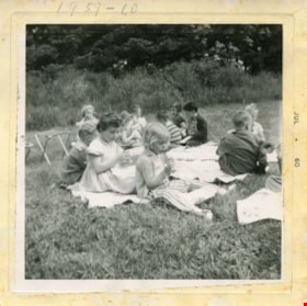
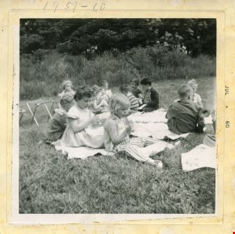
Visit to Deer lake
https://search.heritageburnaby.ca/link/archivedescription52976
- Repository
- City of Burnaby Archives
- Date
- July 1960
- Collection/Fonds
- Burnaby Historical Society fonds
- Description Level
- Item
- Physical Description
- 1 photograph : b&w ; 7.5 x 7.5 cm, mounted on heavy-weight paper 17.5 x 27.5 cm
- Scope and Content
- Photograph of the Tinkerbell Cooperative Kindergarten class on a field trip to Deer lake. They are sitting on blankets, eating a snack.
- Repository
- City of Burnaby Archives
- Date
- July 1960
- Collection/Fonds
- Burnaby Historical Society fonds
- Subseries
- Tinkerbell Kindergarten subseries
- Physical Description
- 1 photograph : b&w ; 7.5 x 7.5 cm, mounted on heavy-weight paper 17.5 x 27.5 cm
- Description Level
- Item
- Record No.
- 246-016
- Access Restriction
- No restrictions
- Reproduction Restriction
- Reproduce for fair dealing purposes only
- Accession Number
- BHS1990-12
- Scope and Content
- Photograph of the Tinkerbell Cooperative Kindergarten class on a field trip to Deer lake. They are sitting on blankets, eating a snack.
- Media Type
- Photograph
- Notes
- Title based on contents of photograph
- Handwritten note on paper mount reads: " Visit to Deer lake / 1960 - 1961 / CLIFFORD / Deborra / Blake / Donna / Stevie / Mrs. Brown / Kindergarten Group"
- Note on recto of photograph reads: "1959 - 60"
- Stamp on recto of photograph reads: "JUL 1960"
- Geographic Access
- Deer Lake
- Deer Lake Park
- Deer Lake Avenue
- Historic Neighbourhood
- Burnaby Lake (Historic Neighbourhood)
- Planning Study Area
- Douglas-Gilpin Area
Images
![Vocational School complex, [between 1963 and 1965] thumbnail](/media/hpo/_Data/_Archives_Images/_Unrestricted/480/480-340.jpg?width=280)
Vocational School complex
https://search.heritageburnaby.ca/link/archivedescription45445
- Repository
- City of Burnaby Archives
- Date
- [between 1963 and 1965]
- Collection/Fonds
- Columbian Newspaper collection
- Description Level
- Item
- Physical Description
- 1 photograph : b&w ; 19 x 23 cm
- Scope and Content
- Photograph of the British Columbia Vocational School complex on Willingdon, next door to the British Columbia Institute of Technology. It would be renamed the Pacific Vocational Institute in 1978, and in 1986, would merge with the British Columbia Institute of Technology and remain a part of that i…
- Repository
- City of Burnaby Archives
- Date
- [between 1963 and 1965]
- Collection/Fonds
- Columbian Newspaper collection
- Physical Description
- 1 photograph : b&w ; 19 x 23 cm
- Description Level
- Item
- Record No.
- 480-340
- Access Restriction
- No restrictions
- Reproduction Restriction
- No restrictions
- Accession Number
- 2003-02
- Scope and Content
- Photograph of the British Columbia Vocational School complex on Willingdon, next door to the British Columbia Institute of Technology. It would be renamed the Pacific Vocational Institute in 1978, and in 1986, would merge with the British Columbia Institute of Technology and remain a part of that institution to the present.
- Media Type
- Photograph
- Photographer
- King, Basil
- Notes
- Title based on contents of photograph
- Geographic Access
- Willingdon Avenue
- Street Address
- 3700 Willingdon Avenue
- Historic Neighbourhood
- Burnaby Lake (Historic Neighbourhood)
- Planning Study Area
- Douglas-Gilpin Area
Images
![Vocational School complex, [between 1963 and 1965] thumbnail](/media/hpo/_Data/_Archives_Images/_Unrestricted/480/480-340.jpg)
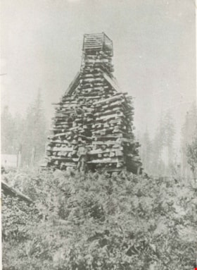
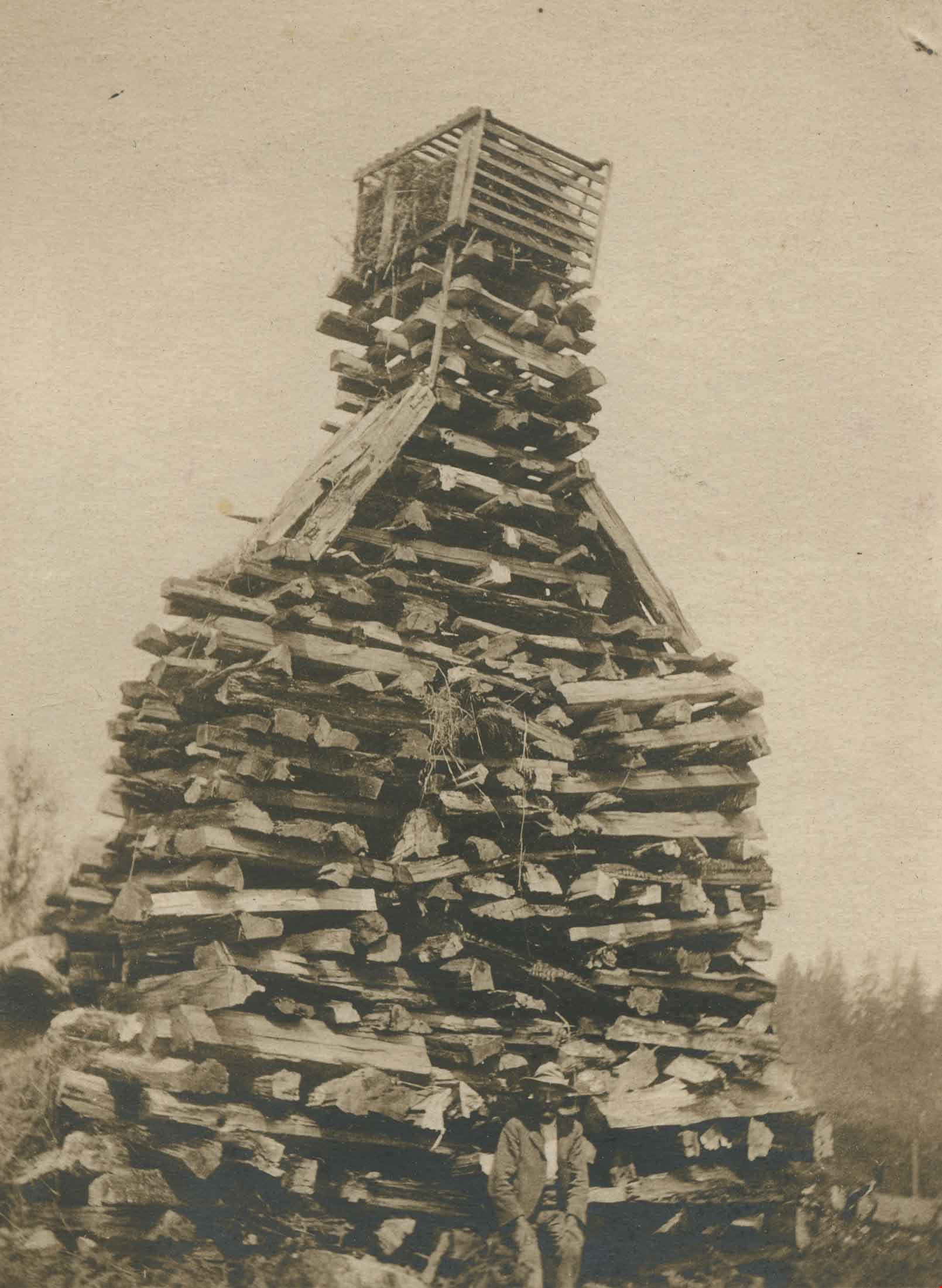
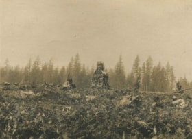
Wood stacked for a bonfire
https://search.heritageburnaby.ca/link/archivedescription35910
- Repository
- City of Burnaby Archives
- Date
- 1897 (date of original), copied 1986
- Collection/Fonds
- Burnaby Historical Society fonds
- Description Level
- Item
- Physical Description
- 1 photograph : b&w ; 12.7 x 17.8 cm print
- Scope and Content
- Photograph of a structure prepared by Claude Hill for a bonfire at Deer Lake celebrating Queen Victoria's Jubilee. The bonfire could be seen for miles around.
- Repository
- City of Burnaby Archives
- Date
- 1897 (date of original), copied 1986
- Collection/Fonds
- Burnaby Historical Society fonds
- Subseries
- Pioneer Tales subseries
- Physical Description
- 1 photograph : b&w ; 12.7 x 17.8 cm print
- Description Level
- Item
- Record No.
- 204-769
- Access Restriction
- No restrictions
- Reproduction Restriction
- No known restrictions
- Accession Number
- BHS1988-03
- Scope and Content
- Photograph of a structure prepared by Claude Hill for a bonfire at Deer Lake celebrating Queen Victoria's Jubilee. The bonfire could be seen for miles around.
- Subjects
- Celebrations - Jubilee
- Media Type
- Photograph
- Notes
- Title based on contents of photograph
- Geographic Access
- Deer Lake Avenue
- Street Address
- 6501 Deer Lake Avenue
- Historic Neighbourhood
- Burnaby Lake (Historic Neighbourhood)
- Planning Study Area
- Morley-Buckingham Area
Images
Wood stacked for a bonfire
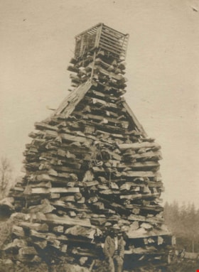
https://search.heritageburnaby.ca/link/archivedescription38852
- Repository
- City of Burnaby Archives
- Date
- 1897
- Collection/Fonds
- Peers Family and Hill Family fonds
- Description Level
- Item
- Physical Description
- 1 photograph : b&w ; 8.5 x 11 cm
- Scope and Content
- Photograph of Claude Hill standing in front of the log pile that he built for a bonfire celebrating Queen Victoria's Diamond jubilee in 1897. The location is near Deer Lake and it was said that the flames from the fire could be seen for miles.
- Repository
- City of Burnaby Archives
- Date
- 1897
- Collection/Fonds
- Peers Family and Hill Family fonds
- Physical Description
- 1 photograph : b&w ; 8.5 x 11 cm
- Description Level
- Item
- Record No.
- 477-171
- Access Restriction
- No restrictions
- Reproduction Restriction
- No known restrictions
- Accession Number
- 2007-12
- Scope and Content
- Photograph of Claude Hill standing in front of the log pile that he built for a bonfire celebrating Queen Victoria's Diamond jubilee in 1897. The location is near Deer Lake and it was said that the flames from the fire could be seen for miles.
- Subjects
- Celebrations - Jubilee
- Media Type
- Photograph
- Notes
- Title based on contents of photograph
- Historic Neighbourhood
- Burnaby Lake (Historic Neighbourhood)
Images
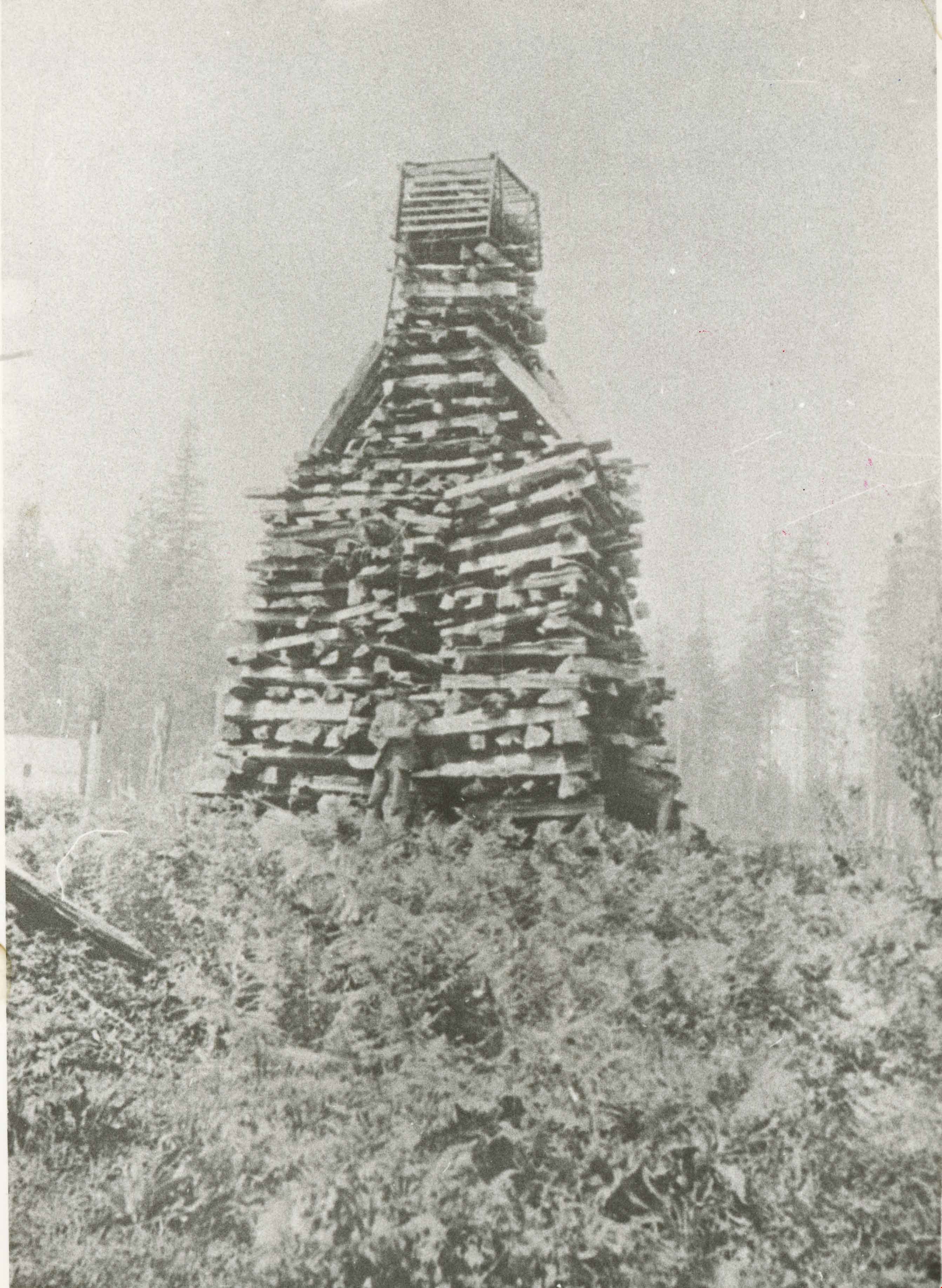
Wood stacked for a bonfire
https://search.heritageburnaby.ca/link/archivedescription39528
- Repository
- City of Burnaby Archives
- Date
- 1897
- Collection/Fonds
- Peers Family and Hill Family fonds
- Description Level
- Item
- Physical Description
- 1 photograph : b&w ; 7 x 9.5 cm on page 21.5 x 28 cm (pasted in album)
- Scope and Content
- Photograph of a large stack of wood, piled up to create a pyre for a bonfire celebrating Queen Victoria's Diamond Jubilee in June, 1897. Claude Hill built this structure near Deer Lake and it was reported that when lit, the fire could be seen for miles.
- Repository
- City of Burnaby Archives
- Date
- 1897
- Collection/Fonds
- Peers Family and Hill Family fonds
- Physical Description
- 1 photograph : b&w ; 7 x 9.5 cm on page 21.5 x 28 cm (pasted in album)
- Description Level
- Item
- Record No.
- 477-847
- Access Restriction
- No restrictions
- Reproduction Restriction
- No known restrictions
- Accession Number
- 2007-12
- Scope and Content
- Photograph of a large stack of wood, piled up to create a pyre for a bonfire celebrating Queen Victoria's Diamond Jubilee in June, 1897. Claude Hill built this structure near Deer Lake and it was reported that when lit, the fire could be seen for miles.
- Subjects
- Celebrations - Jubilee
- Media Type
- Photograph
- Notes
- Title based on contents of photograph
- Geographic Access
- Deer Lake
- Historic Neighbourhood
- Burnaby Lake (Historic Neighbourhood)
Images

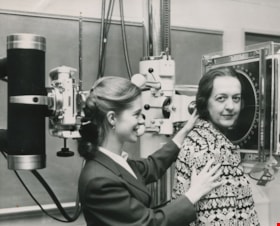
X-ray equipment
https://search.heritageburnaby.ca/link/archivedescription45452
- Repository
- City of Burnaby Archives
- Date
- 1964, published October 6, 1964
- Collection/Fonds
- Columbian Newspaper collection
- Description Level
- Item
- Physical Description
- 1 photograph : b&w ; 15 x 18.5 cm
- Scope and Content
- Photograph of P. M. Boisvert "having her head examined" at the opening of the British Columbia Institute of Technology's opening ceremony. Dianne Modsell of Royal Jubilee hospital in Victoria (then taking a course on radiology at BCIT) is helping her into the "head unit" (x-ray equipment).
- Repository
- City of Burnaby Archives
- Date
- 1964, published October 6, 1964
- Collection/Fonds
- Columbian Newspaper collection
- Physical Description
- 1 photograph : b&w ; 15 x 18.5 cm
- Description Level
- Item
- Record No.
- 480-347
- Access Restriction
- No restrictions
- Reproduction Restriction
- Reproduce for fair dealing purposes only
- Accession Number
- 2003-02
- Scope and Content
- Photograph of P. M. Boisvert "having her head examined" at the opening of the British Columbia Institute of Technology's opening ceremony. Dianne Modsell of Royal Jubilee hospital in Victoria (then taking a course on radiology at BCIT) is helping her into the "head unit" (x-ray equipment).
- Media Type
- Photograph
- Notes
- Title based on contents of photograph
- Geographic Access
- Willingdon Avenue
- Street Address
- 3700 Willingdon Avenue
- Historic Neighbourhood
- Burnaby Lake (Historic Neighbourhood)
- Planning Study Area
- Douglas-Gilpin Area
Images
