Narrow Results By
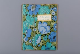
L.A. scrapbook 1964
https://search.heritageburnaby.ca/link/museumdescription4578
- Repository
- Burnaby Village Museum
- Date
- 1962-1971 (date of original), copied 2016
- Collection/Fonds
- Burnaby Girl Guides fonds
- Description Level
- File
- Physical Description
- 1 scrapbook (2 digital files (pdfs) + 55 photographs (tiffs)
- Scope and Content
- File consists of images of a scrapbook containing newspaper clippings, a few original documents about a pet show, a newsletter from 1971 and twelve photographs. The cover of the scrapbook is titled "L.A. Scrapbook 1964" and the inside front page reads: "Lakeview_District_Girl_Guide_Association".
- Repository
- Burnaby Village Museum
- Collection/Fonds
- Burnaby Girl Guides fonds
- Description Level
- File
- Physical Description
- 1 scrapbook (2 digital files (pdfs) + 55 photographs (tiffs)
- Scope and Content
- File consists of images of a scrapbook containing newspaper clippings, a few original documents about a pet show, a newsletter from 1971 and twelve photographs. The cover of the scrapbook is titled "L.A. Scrapbook 1964" and the inside front page reads: "Lakeview_District_Girl_Guide_Association".
- Accession Code
- BV016.49.82
- Access Restriction
- No restrictions
- Reproduction Restriction
- No known restrictions
- Date
- 1962-1971 (date of original), copied 2016
- Media Type
- Textual Record
- Photograph
- Historic Neighbourhood
- Burnaby Lake (Historic Neighbourhood)
- Planning Study Area
- Lakeview-Mayfield Area
- Notes
- Transcribed title
- Selective retention of original records from scrapbook
- Four photographs from scrapbook are described at item level (BV016.49.107 to BV016.49.110)
- Three photographs within scrapbook were created by Bea Walker (BV016.49.107 to BV016.49.109)
Images

Documents
![North side of Burnaby Lake, January 1962 (date of original), copied [1985] thumbnail](/media/hpo/_Data/_BVM_Images/1985/1985_0457_0001_001.jpg?width=280)
North side of Burnaby Lake
https://search.heritageburnaby.ca/link/museumdescription10582
- Repository
- Burnaby Village Museum
- Date
- January 1962 (date of original), copied [1985]
- Collection/Fonds
- Burnaby Village Museum Photograph Collection
- Description Level
- Item
- Physical Description
- 1 photograph : b&w copy negative ; 10 x 12.5 cm
- Scope and Content
- Photograph of the north side of Burnaby Lake January 1962. Preparation for 36 water main crossing at Piper Avenue. The lake and ground are covered with snow.
- Repository
- Burnaby Village Museum
- Collection/Fonds
- Burnaby Village Museum Photograph Collection
- Description Level
- Item
- Physical Description
- 1 photograph : b&w copy negative ; 10 x 12.5 cm
- Scope and Content
- Photograph of the north side of Burnaby Lake January 1962. Preparation for 36 water main crossing at Piper Avenue. The lake and ground are covered with snow.
- Accession Code
- BV985.457.1
- Access Restriction
- No restrictions
- Reproduction Restriction
- May be restricted by third party rights
- Date
- January 1962 (date of original), copied [1985]
- Media Type
- Photograph
- Historic Neighbourhood
- Burnaby Lake (Historic Neighbourhood)
- Planning Study Area
- Burnaby Lake Area
- Scan Resolution
- 1200
- Scan Date
- 2022-06-07
- Photographer
- Lindsay, Jack
- Notes
- Title based on contents of photograph
- Photo by Jack Lindsay Ltd. Photographers, Vancouver. #D28833
Images
![North side of Burnaby Lake, January 1962 (date of original), copied [1985] thumbnail](/media/hpo/_Data/_BVM_Images/1985/1985_0457_0001_001.jpg)
Burnaby Central Secondary School yearbook : 1961-1962
https://search.heritageburnaby.ca/link/museumlibrary5242
- Repository
- Burnaby Village Museum
- Collection
- Special Collection
- Material Type
- Book
- Accession Code
- BV012.17.17
- Call Number
- 373.71 BUR 1962
- Place of Publication
- Burnaby, B.C.
- Publisher
- Burnaby Central Secondary School
- Publication Date
- 1962
- Physical Description
- 100 p. : ill., ports. ; 29 cm.
- Library Subject (LOC)
- School yearbooks--1960-1969
- Schools--British Columbia--Burnaby
- School yearbooks
- Historic Neighbourhood
- Burnaby Lake (Historic Neighbourhood)
- Planning Study Area
- Burnaby Lake Area
- Notes
- High school annual for Burnaby Central high school
Aerial photograph of Burnaby
https://search.heritageburnaby.ca/link/archivedescription84891
- Repository
- City of Burnaby Archives
- Date
- 1963
- Collection/Fonds
- Allan Amundsen collection
- Description Level
- Item
- Physical Description
- 1 photograph : b&w ; 22.5 x 22.5 cm
- Scope and Content
- Aerial photograph of Burnaby north of Lougheed Highway.
- Repository
- City of Burnaby Archives
- Date
- 1963
- Collection/Fonds
- Allan Amundsen collection
- Physical Description
- 1 photograph : b&w ; 22.5 x 22.5 cm
- Description Level
- Item
- Record No.
- 561-012
- Access Restriction
- In Archives only
- Reproduction Restriction
- No reproduction permitted
- Accession Number
- 2014-08
- Scope and Content
- Aerial photograph of Burnaby north of Lougheed Highway.
- Media Type
- Photograph
- Photographer
- Province of British Columbia
- Notes
- Title based on contents of photograph
- This photo is indentified as BC5061:117 and connects with B.C. air photograph BC5061:118 to the east
- Historic Neighbourhood
- Burnaby Lake (Historic Neighbourhood)
- Planning Study Area
- Parkcrest-Aubrey Area
- Ardingley-Sprott Area
Aerial photograph of Burnaby
https://search.heritageburnaby.ca/link/archivedescription84892
- Repository
- City of Burnaby Archives
- Date
- 1963
- Collection/Fonds
- Allan Amundsen collection
- Description Level
- Item
- Physical Description
- 1 photograph : b&w ; 22.5 x 22.5 cm
- Scope and Content
- Aerial photograph of Burnaby north of Lougheed Highway.
- Repository
- City of Burnaby Archives
- Date
- 1963
- Collection/Fonds
- Allan Amundsen collection
- Physical Description
- 1 photograph : b&w ; 22.5 x 22.5 cm
- Description Level
- Item
- Record No.
- 561-013
- Access Restriction
- In Archives only
- Reproduction Restriction
- No reproduction permitted
- Accession Number
- 2014-08
- Scope and Content
- Aerial photograph of Burnaby north of Lougheed Highway.
- Subjects
- Aerial Photographs
- Media Type
- Photograph
- Photographer
- Province of British Columbia
- Notes
- Title based on contents of photograph
- This photo is indentified as BC5061:118 and connects with B.C. air photograph BC5061:117 to the west and BC5061:119 to the east
- Historic Neighbourhood
- Burnaby Lake (Historic Neighbourhood)
- Lozells (Historic Neighbourhood)
- Planning Study Area
- Parkcrest-Aubrey Area
- Ardingley-Sprott Area
- Sperling-Broadway Area
- Government Road Area
Aerial photograph of Burnaby
https://search.heritageburnaby.ca/link/archivedescription84903
- Repository
- City of Burnaby Archives
- Date
- 1963
- Collection/Fonds
- Allan Amundsen collection
- Description Level
- Item
- Physical Description
- 1 photograph : b&w ; 22.5 x 22.5 cm
- Scope and Content
- Aerial photograph of Burnaby with the Trans Canada Highway running through and the Forest Lawn Cemetery to the south.
- Repository
- City of Burnaby Archives
- Date
- 1963
- Collection/Fonds
- Allan Amundsen collection
- Physical Description
- 1 photograph : b&w ; 22.5 x 22.5 cm
- Description Level
- Item
- Record No.
- 561-024
- Access Restriction
- In Archives only
- Reproduction Restriction
- No reproduction permitted
- Accession Number
- 2014-08
- Scope and Content
- Aerial photograph of Burnaby with the Trans Canada Highway running through and the Forest Lawn Cemetery to the south.
- Subjects
- Aerial Photographs
- Media Type
- Photograph
- Photographer
- Province of British Columbia
- Notes
- Title based on contents of photograph
- This photo is indentified as BC5062:27 and connects with B.C. air photograph BC5061:26 to the east
- Historic Neighbourhood
- Burnaby Lake (Historic Neighbourhood)
- Planning Study Area
- Douglas-Gilpin Area
- Ardingley-Sprott Area
- Dawson-Delta Area
Aerial photograph of Burnaby
https://search.heritageburnaby.ca/link/archivedescription84907
- Repository
- City of Burnaby Archives
- Date
- 1963
- Collection/Fonds
- Allan Amundsen collection
- Description Level
- Item
- Physical Description
- 1 photograph : b&w ; 22.5 x 22.5 cm
- Scope and Content
- Aerial photograph of Burnaby with the Trans Canada Highway running from through and Burnaby Lake in the south east corner.
- Repository
- City of Burnaby Archives
- Date
- 1963
- Collection/Fonds
- Allan Amundsen collection
- Physical Description
- 1 photograph : b&w ; 22.5 x 22.5 cm
- Description Level
- Item
- Record No.
- 561-025
- Access Restriction
- In Archives only
- Reproduction Restriction
- No reproduction permitted
- Accession Number
- 2014-08
- Scope and Content
- Aerial photograph of Burnaby with the Trans Canada Highway running from through and Burnaby Lake in the south east corner.
- Subjects
- Aerial Photographs
- Media Type
- Photograph
- Photographer
- Province of British Columbia
- Notes
- Title based on contents of photograph
- This photo is indentified as BC5062:26 and connects with B.C. air photograph BC5062:27 to the west and B.C. air photograph BC5062:25 to the east
- Historic Neighbourhood
- Burnaby Lake (Historic Neighbourhood)
- Planning Study Area
- Douglas-Gilpin Area
- Ardingley-Sprott Area
- Burnaby Lake Area
Aerial photograph of Burnaby Lake Area
https://search.heritageburnaby.ca/link/archivedescription84908
- Repository
- City of Burnaby Archives
- Date
- 1963
- Collection/Fonds
- Allan Amundsen collection
- Description Level
- Item
- Physical Description
- 1 photograph : b&w ; 22.5 x 22.5 cm
- Scope and Content
- Aerial photograph of Burnaby with Lougheed Highway in the north west corner, the Trans Canada Highway in the south east corner and Burnaby Lake appearing from the west.
- Repository
- City of Burnaby Archives
- Date
- 1963
- Collection/Fonds
- Allan Amundsen collection
- Physical Description
- 1 photograph : b&w ; 22.5 x 22.5 cm
- Description Level
- Item
- Record No.
- 561-026
- Access Restriction
- In Archives only
- Reproduction Restriction
- No reproduction permitted
- Accession Number
- 2014-08
- Scope and Content
- Aerial photograph of Burnaby with Lougheed Highway in the north west corner, the Trans Canada Highway in the south east corner and Burnaby Lake appearing from the west.
- Subjects
- Aerial Photographs
- Media Type
- Photograph
- Photographer
- Province of British Columbia
- Notes
- Title based on contents of photograph
- This photo is indentified as BC5062:25 and connects with B.C. air photograph BC5062:26 to the west and B.C. air photograph BC5062:24 to the east
- Historic Neighbourhood
- Burnaby Lake (Historic Neighbourhood)
- Lozells (Historic Neighbourhood)
- Planning Study Area
- Douglas-Gilpin Area
- Sperling-Broadway Area
- Government Road Area
- Burnaby Lake Area
Aerial photograph of Burnaby Lake Area
https://search.heritageburnaby.ca/link/archivedescription84909
- Repository
- City of Burnaby Archives
- Date
- 1963
- Collection/Fonds
- Allan Amundsen collection
- Description Level
- Item
- Physical Description
- 1 photograph : b&w ; 22.5 x 22.5 cm
- Scope and Content
- Aerial photograph of Burnaby with Lougheed Highway to the north and Burnaby Lake to the south.
- Repository
- City of Burnaby Archives
- Date
- 1963
- Collection/Fonds
- Allan Amundsen collection
- Physical Description
- 1 photograph : b&w ; 22.5 x 22.5 cm
- Description Level
- Item
- Record No.
- 561-027
- Access Restriction
- In Archives only
- Reproduction Restriction
- No reproduction permitted
- Accession Number
- 2014-08
- Scope and Content
- Aerial photograph of Burnaby with Lougheed Highway to the north and Burnaby Lake to the south.
- Subjects
- Aerial Photographs
- Media Type
- Photograph
- Photographer
- Province of British Columbia
- Notes
- Title based on contents of photograph
- This photo is indentified as BC5062:24 and connects with B.C. air photograph BC5062:25 to the west and B.C. air photograph BC5062:23 to the east
- Historic Neighbourhood
- Burnaby Lake (Historic Neighbourhood)
- Lozells (Historic Neighbourhood)
- Planning Study Area
- Douglas-Gilpin Area
- Sperling-Broadway Area
- Government Road Area
- Burnaby Lake Area
Aerial photograph of Burnaby Lake Area
https://search.heritageburnaby.ca/link/archivedescription84910
- Repository
- City of Burnaby Archives
- Date
- 1963
- Collection/Fonds
- Allan Amundsen collection
- Description Level
- Item
- Physical Description
- 1 photograph : b&w ; 22.5 x 22.5 cm
- Scope and Content
- Aerial photograph of Burnaby with Burnaby Lake to the south and Broadway to the north.
- Repository
- City of Burnaby Archives
- Date
- 1963
- Collection/Fonds
- Allan Amundsen collection
- Physical Description
- 1 photograph : b&w ; 22.5 x 22.5 cm
- Description Level
- Item
- Record No.
- 561-028
- Access Restriction
- In Archives only
- Reproduction Restriction
- No reproduction permitted
- Accession Number
- 2014-08
- Scope and Content
- Aerial photograph of Burnaby with Burnaby Lake to the south and Broadway to the north.
- Subjects
- Aerial Photographs
- Media Type
- Photograph
- Photographer
- Province of British Columbia
- Notes
- Title based on contents of photograph
- This photo is indentified as BC5062:23 and connects with B.C. air photograph BC5062:24 to the west and B.C. air photograph BC5062:22 to the east
- Historic Neighbourhood
- Burnaby Lake (Historic Neighbourhood)
- Lozells (Historic Neighbourhood)
- Planning Study Area
- Lake City Area
- Government Road Area
- Burnaby Lake Area
![Burnaby Winter Club, [1963] thumbnail](/media/hpo/_Data/_Archives_Images/_Unrestricted/001/068-001.jpg?width=280)
Burnaby Winter Club
https://search.heritageburnaby.ca/link/archivedescription34632
- Repository
- City of Burnaby Archives
- Date
- [1963]
- Collection/Fonds
- Burnaby Historical Society fonds
- Description Level
- Item
- Physical Description
- 1 photograph : b&w ; 17.5 x 19.7 cm
- Scope and Content
- Photograph of the Burnaby Winter Club at 4990 Canada Way. Three sheep and a horse are standing in a field by a building.
- Repository
- City of Burnaby Archives
- Date
- [1963]
- Collection/Fonds
- Burnaby Historical Society fonds
- Subseries
- Photographs subseries
- Physical Description
- 1 photograph : b&w ; 17.5 x 19.7 cm
- Description Level
- Item
- Record No.
- 068-001
- Access Restriction
- No restrictions
- Reproduction Restriction
- Reproduce for fair dealing purposes only
- Accession Number
- BHS2007-04
- Scope and Content
- Photograph of the Burnaby Winter Club at 4990 Canada Way. Three sheep and a horse are standing in a field by a building.
- Names
- Burnaby Winter Club
- Media Type
- Photograph
- Notes
- Title based on contents of photograph
- Geographic Access
- Canada Way
- Street Address
- 4990 Canada Way
- Historic Neighbourhood
- Burnaby Lake (Historic Neighbourhood)
- Planning Study Area
- Douglas-Gilpin Area
Images
![Burnaby Winter Club, [1963] thumbnail](/media/hpo/_Data/_Archives_Images/_Unrestricted/001/068-001.jpg)

Madelaine Anderson
https://search.heritageburnaby.ca/link/archivedescription37452
- Repository
- City of Burnaby Archives
- Date
- 1963 (date of original), copied 1991
- Collection/Fonds
- Burnaby Historical Society fonds
- Description Level
- Item
- Physical Description
- 1 photograph : b&w ; 3.2 x 3.2 cm print on contact sheet 20.2 x 25.4 cm
- Scope and Content
- Photograph of Madelaine Anderson at the back of her home at 3908 Norland Avenue (previously numbered 4437 Norland Avenue), facing northwest. The Sprott overpass over the Trans Canada Highway can be seen under construction in the background.
- Repository
- City of Burnaby Archives
- Date
- 1963 (date of original), copied 1991
- Collection/Fonds
- Burnaby Historical Society fonds
- Subseries
- Burnaby Image Bank subseries
- Physical Description
- 1 photograph : b&w ; 3.2 x 3.2 cm print on contact sheet 20.2 x 25.4 cm
- Description Level
- Item
- Record No.
- 370-040
- Access Restriction
- No restrictions
- Reproduction Restriction
- No restrictions
- Accession Number
- BHS1999-03
- Scope and Content
- Photograph of Madelaine Anderson at the back of her home at 3908 Norland Avenue (previously numbered 4437 Norland Avenue), facing northwest. The Sprott overpass over the Trans Canada Highway can be seen under construction in the background.
- Media Type
- Photograph
- Notes
- Title based on contents of photograph
- 1 b&w copy negative accompanying
- Photo is missing pieces at centre and bottom left
- Geographic Access
- Norland Avenue
- Street Address
- 3908 Norland Avenue
- Historic Neighbourhood
- Burnaby Lake (Historic Neighbourhood)
- Planning Study Area
- Douglas-Gilpin Area
Images

Janet and Cliff Anderson
https://search.heritageburnaby.ca/link/archivedescription37453
- Repository
- City of Burnaby Archives
- Date
- 1963 (date of original), copied 1991
- Collection/Fonds
- Burnaby Historical Society fonds
- Description Level
- Item
- Physical Description
- 1 photograph : b&w ; 4.1 x 3.4 cm print on contact sheet 20.2 x 25.4 cm
- Scope and Content
- Photograph of siblings Janet and Cliff Anderson standing beside a small pond behind their home at 3908 Norland Avenue (previously numbered 4437 Norland Avenue). The photograph was taken facing northwest. The Sprott overpass over the Trans Canada Highway can be seen under construction in the backgr…
- Repository
- City of Burnaby Archives
- Date
- 1963 (date of original), copied 1991
- Collection/Fonds
- Burnaby Historical Society fonds
- Subseries
- Burnaby Image Bank subseries
- Physical Description
- 1 photograph : b&w ; 4.1 x 3.4 cm print on contact sheet 20.2 x 25.4 cm
- Description Level
- Item
- Record No.
- 370-041
- Access Restriction
- No restrictions
- Reproduction Restriction
- No restrictions
- Accession Number
- BHS1999-03
- Scope and Content
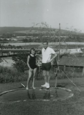
- Photograph of siblings Janet and Cliff Anderson standing beside a small pond behind their home at 3908 Norland Avenue (previously numbered 4437 Norland Avenue). The photograph was taken facing northwest. The Sprott overpass over the Trans Canada Highway can be seen under construction in the background
- Media Type
- Photograph
- Notes
- Title based on contents of photograph
- 1 b&w copy negative accompanying
- Geographic Access
- Norland Avenue
- Street Address
- 3908 Norland Avenue
- Historic Neighbourhood
- Burnaby Lake (Historic Neighbourhood)
- Planning Study Area
- Douglas-Gilpin Area
Images

![Vocational School complex, [between 1963 and 1965] thumbnail](/media/hpo/_Data/_Archives_Images/_Unrestricted/480/480-340.jpg?width=280)
Vocational School complex
https://search.heritageburnaby.ca/link/archivedescription45445
- Repository
- City of Burnaby Archives
- Date
- [between 1963 and 1965]
- Collection/Fonds
- Columbian Newspaper collection
- Description Level
- Item
- Physical Description
- 1 photograph : b&w ; 19 x 23 cm
- Scope and Content
- Photograph of the British Columbia Vocational School complex on Willingdon, next door to the British Columbia Institute of Technology. It would be renamed the Pacific Vocational Institute in 1978, and in 1986, would merge with the British Columbia Institute of Technology and remain a part of that i…
- Repository
- City of Burnaby Archives
- Date
- [between 1963 and 1965]
- Collection/Fonds
- Columbian Newspaper collection
- Physical Description
- 1 photograph : b&w ; 19 x 23 cm
- Description Level
- Item
- Record No.
- 480-340
- Access Restriction
- No restrictions
- Reproduction Restriction
- No restrictions
- Accession Number
- 2003-02
- Scope and Content
- Photograph of the British Columbia Vocational School complex on Willingdon, next door to the British Columbia Institute of Technology. It would be renamed the Pacific Vocational Institute in 1978, and in 1986, would merge with the British Columbia Institute of Technology and remain a part of that institution to the present.
- Media Type
- Photograph
- Photographer
- King, Basil
- Notes
- Title based on contents of photograph
- Geographic Access
- Willingdon Avenue
- Street Address
- 3700 Willingdon Avenue
- Historic Neighbourhood
- Burnaby Lake (Historic Neighbourhood)
- Planning Study Area
- Douglas-Gilpin Area
Images
![Vocational School complex, [between 1963 and 1965] thumbnail](/media/hpo/_Data/_Archives_Images/_Unrestricted/480/480-340.jpg)
Burnaby Central Secondary School yearbook : 1962-1963
https://search.heritageburnaby.ca/link/museumlibrary5239
- Repository
- Burnaby Village Museum
- Collection
- Special Collection
- Material Type
- Book
- Accession Code
- BV012.17.16
- Call Number
- 373.71 BUR 1963
- Place of Publication
- Burnaby, B.C.
- Publisher
- Burnaby Central Secondary School
- Publication Date
- 1963
- Physical Description
- 1 v. (unpaged) : ill., ports. ; 29 cm.
- Library Subject (LOC)
- School yearbooks--1960-1969
- Schools--British Columbia--Burnaby
- School yearbooks
- Historic Neighbourhood
- Burnaby Lake (Historic Neighbourhood)
- Planning Study Area
- Burnaby Lake Area
- Notes
- High school annual for Burnaby Central high school
Douglas Road
https://search.heritageburnaby.ca/link/archivedescription36053
- Repository
- City of Burnaby Archives
- Date
- 1964
- Collection/Fonds
- Burnaby Historical Society fonds
- Description Level
- Item
- Physical Description
- 1 photograph : b&w ; 11.5 x 16 cm
- Scope and Content
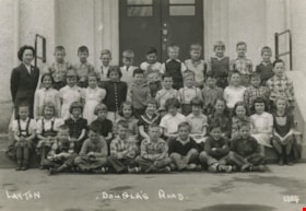
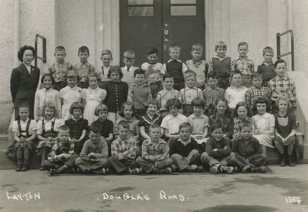
- Photograph of Marietta Ketchum (far left) and her class at Douglas Road School lined up in rows on the steps of the school.
- Repository
- City of Burnaby Archives
- Date
- 1964
- Collection/Fonds
- Burnaby Historical Society fonds
- Subseries
- Grace Dickie subseries
- Physical Description
- 1 photograph : b&w ; 11.5 x 16 cm
- Material Details
- Photographer wrote their name and the date on the negative, making both white on the photograph
- Description Level
- Item
- Record No.
- 215-011
- Access Restriction
- No restrictions
- Reproduction Restriction
- Reproduce for fair dealing purposes only
- Accession Number
- BHS1989-03
- Scope and Content
- Photograph of Marietta Ketchum (far left) and her class at Douglas Road School lined up in rows on the steps of the school.
- Subjects
- Occupations - Teachers
- Media Type
- Photograph
- Notes
- Photographer identified as "Layton"
- Geographic Access
- Canada Way
- Street Address
- 4861 Canada Way
- Historic Neighbourhood
- Burnaby Lake (Historic Neighbourhood)
- Planning Study Area
- Douglas-Gilpin Area
Images
![British Columbia Institute of Technology campus, [1964] published February 5, 1964 thumbnail](/media/hpo/_Data/_Archives_Images/_Unrestricted/480/480-332.jpg?width=280)
British Columbia Institute of Technology campus
https://search.heritageburnaby.ca/link/archivedescription45437
- Repository
- City of Burnaby Archives
- Date
- [1964] published February 5, 1964
- Collection/Fonds
- Columbian Newspaper collection
- Description Level
- Item
- Physical Description
- 1 photograph : b&w ; 7.5 x 23 cm
- Scope and Content
- Photograph of the British Columbia Institute of Technology campus.
- Repository
- City of Burnaby Archives
- Date
- [1964] published February 5, 1964
- Collection/Fonds
- Columbian Newspaper collection
- Physical Description
- 1 photograph : b&w ; 7.5 x 23 cm
- Description Level
- Item
- Record No.
- 480-332
- Access Restriction
- No restrictions
- Reproduction Restriction
- No restrictions
- Accession Number
- 2003-02
- Scope and Content
- Photograph of the British Columbia Institute of Technology campus.
- Media Type
- Photograph
- Photographer
- King, Basil
- Notes
- Title based on contents of photograph
- Geographic Access
- Willingdon Avenue
- Street Address
- 3700 Willingdon Avenue
- Historic Neighbourhood
- Burnaby Lake (Historic Neighbourhood)
- Planning Study Area
- Douglas-Gilpin Area
Images
![British Columbia Institute of Technology campus, [1964] published February 5, 1964 thumbnail](/media/hpo/_Data/_Archives_Images/_Unrestricted/480/480-332.jpg)
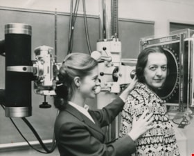
X-ray equipment
https://search.heritageburnaby.ca/link/archivedescription45452
- Repository
- City of Burnaby Archives
- Date
- 1964, published October 6, 1964
- Collection/Fonds
- Columbian Newspaper collection
- Description Level
- Item
- Physical Description
- 1 photograph : b&w ; 15 x 18.5 cm
- Scope and Content
- Photograph of P. M. Boisvert "having her head examined" at the opening of the British Columbia Institute of Technology's opening ceremony. Dianne Modsell of Royal Jubilee hospital in Victoria (then taking a course on radiology at BCIT) is helping her into the "head unit" (x-ray equipment).
- Repository
- City of Burnaby Archives
- Date
- 1964, published October 6, 1964
- Collection/Fonds
- Columbian Newspaper collection
- Physical Description
- 1 photograph : b&w ; 15 x 18.5 cm
- Description Level
- Item
- Record No.
- 480-347
- Access Restriction
- No restrictions
- Reproduction Restriction
- Reproduce for fair dealing purposes only
- Accession Number
- 2003-02
- Scope and Content
- Photograph of P. M. Boisvert "having her head examined" at the opening of the British Columbia Institute of Technology's opening ceremony. Dianne Modsell of Royal Jubilee hospital in Victoria (then taking a course on radiology at BCIT) is helping her into the "head unit" (x-ray equipment).
- Media Type
- Photograph
- Notes
- Title based on contents of photograph
- Geographic Access
- Willingdon Avenue
- Street Address
- 3700 Willingdon Avenue
- Historic Neighbourhood
- Burnaby Lake (Historic Neighbourhood)
- Planning Study Area
- Douglas-Gilpin Area
Images

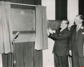
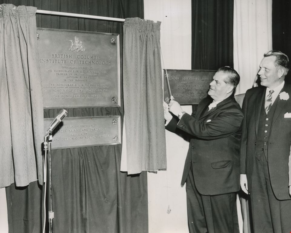
Official opening by Premier W. A. C. Bennett
https://search.heritageburnaby.ca/link/archivedescription45453
- Repository
- City of Burnaby Archives
- Date
- October 5, 1964
- Collection/Fonds
- Columbian Newspaper collection
- Description Level
- Item
- Physical Description
- 1 photograph : b&w ; 15 x 18.5 cm
- Scope and Content
- Photograph of W.A.C. Bennett pulling back the curtain to unveil the plaque at the official opening of the British Columbia Institute of Technology.
- Repository
- City of Burnaby Archives
- Date
- October 5, 1964
- Collection/Fonds
- Columbian Newspaper collection
- Physical Description
- 1 photograph : b&w ; 15 x 18.5 cm
- Description Level
- Item
- Record No.
- 480-348
- Access Restriction
- No restrictions
- Reproduction Restriction
- Reproduce for fair dealing purposes only
- Accession Number
- 2003-02
- Scope and Content
- Photograph of W.A.C. Bennett pulling back the curtain to unveil the plaque at the official opening of the British Columbia Institute of Technology.
- Subjects
- Events - Openings
- Officials - Premiers
- Media Type
- Photograph
- Notes
- Title based on contents of photograph
- Geographic Access
- Willingdon Avenue
- Street Address
- 3700 Willingdon Avenue
- Historic Neighbourhood
- Burnaby Lake (Historic Neighbourhood)
- Planning Study Area
- Douglas-Gilpin Area
Images
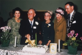
Tom Irvine on his one hundredth birthday
https://search.heritageburnaby.ca/link/museumdescription1867
- Repository
- Burnaby Village Museum
- Date
- March 7, 1964
- Collection/Fonds
- Century Park Museum Association fonds
- Description Level
- Item
- Physical Description
- 1 photograph : col. ; 9 x 13.5 cm
- Scope and Content
- Photograph of (from left); Olive Procter, Tom Irvine, Mrs. H. Clarke, Mrs. Emmott and Reeve Alan Emmott at Tom Irvine's one hundredth birthday celebration at Deer Lake United Church. Tom Irvine was a member of the Deer Lake Golden Age Club.
- Repository
- Burnaby Village Museum
- Collection/Fonds
- Century Park Museum Association fonds
- Description Level
- Item
- Physical Description
- 1 photograph : col. ; 9 x 13.5 cm
- Material Details
- .
- Scope and Content
- Photograph of (from left); Olive Procter, Tom Irvine, Mrs. H. Clarke, Mrs. Emmott and Reeve Alan Emmott at Tom Irvine's one hundredth birthday celebration at Deer Lake United Church. Tom Irvine was a member of the Deer Lake Golden Age Club.
- Subjects
- Celebrations
- Names
- Irvine, Tom
- Proctor, Olive
- Clarke, Mrs. H.
- Emmott, Alan H.
- Emmott, Mrs.
- Deer Lake United Church
- Geographic Access
- Sperling Avenue
- Street Address
- 5135 Sperling Avenue
- Accession Code
- BV005.14.20
- Access Restriction
- Restricted access
- Reproduction Restriction
- May be restricted by third party rights
- Date
- March 7, 1964
- Media Type
- Photograph
- Historic Neighbourhood
- Burnaby Lake (Historic Neighbourhood)
- Planning Study Area
- Morley-Buckingham Area
- Scan Resolution
- 600
- Scan Date
- 11-Jun-09
- Scale
- 100
- Notes
- Title based on contents of photograph
- Note in black ink on verso of photograph reads: "(Left to right) Olive Procter, Tom Irvine, Mrs. H. Clarke, Mrs Emmott, Reeve Alan Emmott. Taken at Deer Lake United Church - on Tom's 100th birthday March 7, 1964. He was a member of the Deer Lake Golden Age Club."
Images
