Narrow Results By
Creator
- Adams, John 2
- British Columbia Underwriters' Association 1
- Burnaby Village Museum 7
- Burnett & McGugan, Engineers and Surveyors 1
- Canadian Broadcasting Corporation 1
- Carr, William Harold 1
- City of Burnaby 4
- Columbian Photo Limited 5
- Cooksley, William Thomas 2
- Crawford, T. James (Thomas James) 1
- Damer, Eric 3
- Debbie Liang 1

Bird's Eye View of the Burnaby Lake Area
https://search.heritageburnaby.ca/link/museumdescription15144
- Repository
- Burnaby Village Museum
- Date
- 1977
- Collection/Fonds
- Century Park Museum Association fonds
- Description Level
- Item
- Physical Description
- 1 map : b&w print on paper ; 43 x 63.5 cm
- Scope and Content
- Item consists of a map titled "Birds Eye View of the Burnaby Lake Area Circa 1910". The overview of the Burnaby Lake area was compiled and drawn at Heritage Village by curator John Adams and artist, Carol Swan. The map identifies the Burnaby Lake inter-urban tram line; roads including: Sperling Ave…
- Repository
- Burnaby Village Museum
- Collection/Fonds
- Century Park Museum Association fonds
- Description Level
- Item
- Physical Description
- 1 map : b&w print on paper ; 43 x 63.5 cm
- Material Details
- Scale indeterminable
- Scope and Content
- Item consists of a map titled "Birds Eye View of the Burnaby Lake Area Circa 1910". The overview of the Burnaby Lake area was compiled and drawn at Heritage Village by curator John Adams and artist, Carol Swan. The map identifies the Burnaby Lake inter-urban tram line; roads including: Sperling Avenue (Pole Line Road); Gilpin Avenue; Douglas Road; trail to Vancouver Westminster Road (Kingsway); Buckingham Avenue; Haszard Street; various farms and residences including: Charles Sprott "Norland"; H.T. Ceperley "Fairacres"; Claude Hill's "Brookfield farm" and "Broadview"; F.J. Hart's "Avalon"; Miss Woodward's former and new home, school and post office; Councillor Edgar's hunting cabin; Edgar Sprott's "Mayfield farm" and "Mayfield Lodge"; F.J. Peers "Greyfriars"; Arthur de Windt Haszard; Bernard Hill's boathouse as well as other landmarks including: Doran's Mill; tram stations; Burnaby Lake Store; logging camps; wood cutter's shacks; ice houses; cranberry bog; Still Creek; Deer Lake; Burnaby Lake; Deer Lake Creek; Provincial Government Reserve Proposed Hospital (later Oakalla Prison).
- Creator
- Adams, John
- Swan, Carol
- Names
- Hill, Arthur Claude
- Sprott, Charles Frederick
- Sprott, Louis "Edgar"
- Hart, Frederick John, 1884-1945
- Ceperley, H.T.
- Woodward, Maude
- Woodward, Harriet
- Peers, Francis J.
- Haszard, Arthur de Windt
- Hill, Bernard R.
- Geographic Access
- Deer Lake Avenue
- Sperling Avenue
- Haszard Street
- Buckingham Avenue
- Accession Code
- BV021.1.3
- Access Restriction
- No restrictions
- Reproduction Restriction
- No known restrictions
- Date
- 1977
- Media Type
- Cartographic Material
- Historic Neighbourhood
- Burnaby Lake (Historic Neighbourhood)
- Planning Study Area
- Burnaby Lake Area
- Related Material
- See also: Life with the Moores of Hart House : pioneer days on Burnaby's Deer Lake
- Scan Resolution
- 600
- Scan Date
- 2021-11-12
- Scale
- 100
- Notes
- Transcribed title
- Compiled by John Adams; illustration by Carol Swan
- The map depicts the Burnaby Lake Tram Line as being double tracked, whereas in reality it was single tracked.
- Map is part of the book "Life with the Moores of Hart House : pioneer days on Burnaby's Deer Lake https://search.heritageburnaby.ca/permalink/museumlibrary6314-102
Images


Bird's Eye View of the Burnaby Lake Area
https://search.heritageburnaby.ca/link/museumdescription17543
- Repository
- Burnaby Village Museum
- Date
- 1977
- Collection/Fonds
- Century Park Museum Association fonds
- Description Level
- Item
- Physical Description
- 1 map : b&w print with watercolour ; 43 x 63.5 cm
- Scope and Content
- Item consists of a map titled "Birds Eye View of the Burnaby Lake Area Circa 1910". The overview of the Burnaby Lake area was compiled and drawn at Heritage Village by curator John Adams and artist, Carol Swan. The map identifies the Burnaby Lake inter-urban tram line; roads including: Sperling Ave…
- Repository
- Burnaby Village Museum
- Collection/Fonds
- Century Park Museum Association fonds
- Description Level
- Item
- Physical Description
- 1 map : b&w print with watercolour ; 43 x 63.5 cm
- Material Details
- Scale indeterminable
- Scope and Content
- Item consists of a map titled "Birds Eye View of the Burnaby Lake Area Circa 1910". The overview of the Burnaby Lake area was compiled and drawn at Heritage Village by curator John Adams and artist, Carol Swan. The map identifies the Burnaby Lake inter-urban tram line; roads including: Sperling Avenue (Pole Line Road); Gilpin Avenue; Douglas Road; trail to Vancouver Westminster Road (Kingsway); Buckingham Avenue; Haszard Street; various farms and residences including: Charles Sprott "Norland"; H.T. Ceperley "Fairacres"; Claude Hill's "Brookfield farm" and "Broadview"; F.J. Hart's "Avalon"; Miss Woodward's former and new home, school and post office; Councillor Edgar's hunting cabin; Edgar Sprott's "Mayfield farm" and "Mayfield Lodge"; F.J. Peers "Greyfriars"; Arthur de Windt Haszard; Bernard Hill's boathouse as well as other landmarks including: Doran's Mill; tram stations; Burnaby Lake Store; logging camps; wood cutter's shacks; ice houses; cranberry bog; Still Creek; Deer Lake; Burnaby Lake; Deer Lake Creek; Provincial Government Reserve Proposed Hospital (later Oakalla Prison).
- Creator
- Adams, John
- Swan, Carol
- Names
- Hill, Arthur Claude
- Sprott, Charles Frederick
- Sprott, Louis "Edgar"
- Hart, Frederick John, 1884-1945
- Ceperley, H.T.
- Woodward, Maude
- Woodward, Harriet
- Peers, Francis J.
- Haszard, Arthur de Windt
- Hill, Bernard R.
- Geographic Access
- Deer Lake Avenue
- Sperling Avenue
- Haszard Street
- Buckingham Avenue
- Accession Code
- BV021.1.4
- Access Restriction
- No restrictions
- Reproduction Restriction
- No known restrictions
- Date
- 1977
- Media Type
- Cartographic Material
- Historic Neighbourhood
- Burnaby Lake (Historic Neighbourhood)
- Planning Study Area
- Burnaby Lake Area
- Related Material
- See also: Life with the Moores of Hart House : pioneer days on Burnaby's Deer Lake
- Scan Resolution
- 600
- Scan Date
- 2021-11-12
- Scale
- 100
- Notes
- Transcribed title
- Compiled by John Adams; illustration by Carol Swan
- The map depicts the Burnaby Lake Tram Line as being double tracked, whereas in reality it was single tracked.
- Map is part of the book "Life with the Moores of Hart House : pioneer days on Burnaby's Deer Lake https://search.heritageburnaby.ca/permalink/museumlibrary6314-102
- This is a print made from original illustration and appears to be hand-coloured with watercolour at a later date.
Images

Blacksmith shop building at Oakalla Prison Farm
https://search.heritageburnaby.ca/link/museumdescription17852
- Repository
- Burnaby Village Museum
- Date
- 1991
- Collection/Fonds
- Oakalla Prison collection
- Description Level
- Item
- Physical Description
- 1 photograph : col. negative ; 35 mm
- Scope and Content
- Photograph of old blacksmith shop building at Oakalla Prison Farm (Lower Mainland Regional Correctional Centre). Acccording to photographer, this building was later used as a "Doukhobor hut". Photograph was taken during Oakalla Prison Open House event.
- Repository
- Burnaby Village Museum
- Collection/Fonds
- Oakalla Prison collection
- Description Level
- Item
- Physical Description
- 1 photograph : col. negative ; 35 mm
- Scope and Content
- Photograph of old blacksmith shop building at Oakalla Prison Farm (Lower Mainland Regional Correctional Centre). Acccording to photographer, this building was later used as a "Doukhobor hut". Photograph was taken during Oakalla Prison Open House event.
- Subjects
- Public Services - Correctional
- Geographic Access
- Oakmount Crescent
- Street Address
- 5220 Oakmount Crescent
- Accession Code
- BV991.45.636
- Access Restriction
- No restrictions
- Reproduction Restriction
- No known restrictions
- Date
- 1991
- Media Type
- Photograph
- Historic Neighbourhood
- Burnaby Lake (Historic Neighbourhood)
- Planning Study Area
- Oakalla Area
- Photographer
- Stevens, Colin
- Notes
- Title based on contents of photograph
- Photograph negative #17 from Roll 91-8
- 1 col. copy print accompanying
- Note in black ink on verso of accompanying copy print reads: "P91-8-17"
- Note in blue in ink on verso of accompanying copy print reads: "OLD BLACKSMITH SHOP / LATER DUKABOR HUT"
Images
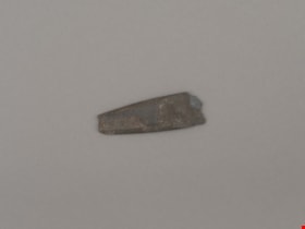
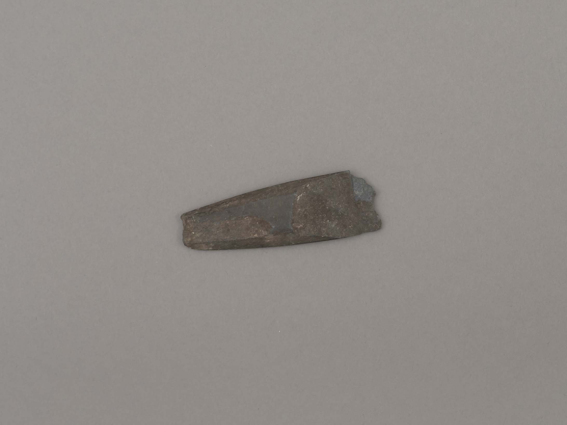
blade or projectile
https://search.heritageburnaby.ca/link/museumartifact44879
- Repository
- Burnaby Village Museum
- Accession Code
- BV002.57.30
- Description
- Ground slate point
- Object History
- The donor inherited this artifact from his mother, Katherine Maude (Kitty) Peers, who inherited them from her father, Louis Claude Hill. The artifacts were found on his farm, Brookfield Farm, at Douglas Road and Sperling Avenue (now site of Burnaby Village Museum).
- Culture Phase: Locarno Beach phase (3520-2200 Before Present)
- Historic Neighbourhood
- Burnaby Lake (Historic Neighbourhood)
Images
Documents
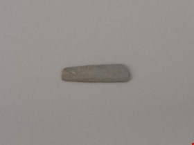
blade or projectile point
https://search.heritageburnaby.ca/link/museumartifact44878
- Repository
- Burnaby Village Museum
- Accession Code
- BV002.57.29
- Description
- Ground and faceted stone point
- Object History
- The donor inherited this artifact from his mother, Katherine Maude (Kitty) Peers, who inherited them from her father, Louis Claude Hill. The artifacts were found on his farm, Brookfield Farm, at Douglas Road and Sperling Avenue (now site of Burnaby Village Museum).
- Culture Phase: Locarno Beach phase (3520-2200 Before Present)
- Historic Neighbourhood
- Burnaby Lake (Historic Neighbourhood)
Images

Documents
![Boal family home, [1938 or 1939] thumbnail](/media/hpo/_Data/_BVM_Images/2017/201700280020_001.jpg?width=280)
Boal family home
https://search.heritageburnaby.ca/link/museumdescription4213
- Repository
- Burnaby Village Museum
- Date
- [1938 or 1939]
- Collection/Fonds
- Burnaby Village Museum Photograph collection
- Description Level
- Item
- Physical Description
- 1 photograph : b&w ; 8 x 12 cm
- Scope and Content
- Photograph of the Boal home at 4319 Norland Ave in Burnaby. The photo is face on to the house looking west(?), the whole house is shown. Mr and Mrs Boal (William Ewart Boal and Ethel May Boal, nee Jackson) are standing on the front porch.
- Repository
- Burnaby Village Museum
- Collection/Fonds
- Burnaby Village Museum Photograph collection
- Description Level
- Item
- Physical Description
- 1 photograph : b&w ; 8 x 12 cm
- Material Details
- Stamped numeral on back of photograph reads: "305".
- Scope and Content
- Photograph of the Boal home at 4319 Norland Ave in Burnaby. The photo is face on to the house looking west(?), the whole house is shown. Mr and Mrs Boal (William Ewart Boal and Ethel May Boal, nee Jackson) are standing on the front porch.
- History
- Material belonged to Glen and Ann Boal (nee Lockhart), who grew up in Burnaby and attended Burnaby South High School. They met and became engaged and married in 1954.
- Geographic Access
- Norland Avenue
- Street Address
- 4319 Norland Avenue
- Accession Code
- BV017.28.20
- Access Restriction
- No restrictions
- Reproduction Restriction
- No known restrictions
- Date
- [1938 or 1939]
- Media Type
- Photograph
- Historic Neighbourhood
- Burnaby Lake (Historic Neighbourhood)
- Planning Study Area
- Burnaby Lake Area
- Scan Resolution
- 600
- Scan Date
- 06-Mar-2018
- Notes
- Title based on contents of photograph
Images
![Boal family home, [1938 or 1939] thumbnail](/media/hpo/_Data/_BVM_Images/2017/201700280020_001.jpg)
![Boal family home, [1938 or 1939] thumbnail](/media/hpo/_Data/_BVM_Images/2017/201700280021_001.jpg?width=280)
Boal family home
https://search.heritageburnaby.ca/link/museumdescription4214
- Repository
- Burnaby Village Museum
- Date
- [1938 or 1939]
- Collection/Fonds
- Burnaby Village Museum Photograph collection
- Description Level
- Item
- Physical Description
- 1 photograph : b&w ; 8 x 12 cm
- Scope and Content
- Photograph of the Boal home at 4319 Norland Ave in Burnaby. The photo is face on to the house looking west(?), the whole house is shown. Mr and Mrs Boal (William Ewart Boal and Ethel May Boal, nee Jackson) are standing on the front porch.
- Repository
- Burnaby Village Museum
- Collection/Fonds
- Burnaby Village Museum Photograph collection
- Description Level
- Item
- Physical Description
- 1 photograph : b&w ; 8 x 12 cm
- Material Details
- Stamped numeral on back of photograph reads: "51".
- Scope and Content
- Photograph of the Boal home at 4319 Norland Ave in Burnaby. The photo is face on to the house looking west(?), the whole house is shown. Mr and Mrs Boal (William Ewart Boal and Ethel May Boal, nee Jackson) are standing on the front porch.
- History
- Material belonged to Glen and Ann Boal (nee Lockhart), who grew up in Burnaby and attended Burnaby South High School. They met and became engaged and married in 1954.
- Geographic Access
- Norland Avenue
- Street Address
- 4319 Norland Avenue
- Accession Code
- BV017.28.21
- Access Restriction
- No restrictions
- Reproduction Restriction
- No known restrictions
- Date
- [1938 or 1939]
- Media Type
- Photograph
- Historic Neighbourhood
- Burnaby Lake (Historic Neighbourhood)
- Planning Study Area
- Burnaby Lake Area
- Scan Resolution
- 600
- Scan Date
- 06-Mar-2018
- Notes
- Title based on contents of photograph
Images
![Boal family home, [1938 or 1939] thumbnail](/media/hpo/_Data/_BVM_Images/2017/201700280021_001.jpg)
![Boal family home, [1950] thumbnail](/media/hpo/_Data/_BVM_Images/2017/201700280022_001.jpg?width=280)
Boal family home
https://search.heritageburnaby.ca/link/museumdescription4215
- Repository
- Burnaby Village Museum
- Date
- [1950]
- Collection/Fonds
- Burnaby Village Museum Photograph collection
- Description Level
- Item
- Physical Description
- 1 photograph : b&w ; 6.5 x 9 cm
- Scope and Content
- Photograph of the Boal home at 4319 Norland Ave in Burnaby. This is a three-quarter shot of the house which has new, light coloured siding (white?) and a garage in the back. A man is mowing the lawn next to the house.
- Repository
- Burnaby Village Museum
- Collection/Fonds
- Burnaby Village Museum Photograph collection
- Description Level
- Item
- Physical Description
- 1 photograph : b&w ; 6.5 x 9 cm
- Material Details
- Handwritten text in ink on front of photograph reads: "1950".
- Stamped numeral on back of photograph reads: "452".
- Handwritten text on back of photograph reads: "summer, 1950 / Boals' house".
- Scope and Content
- Photograph of the Boal home at 4319 Norland Ave in Burnaby. This is a three-quarter shot of the house which has new, light coloured siding (white?) and a garage in the back. A man is mowing the lawn next to the house.
- History
- Material belonged to Glen and Ann Boal (nee Lockhart), who grew up in Burnaby and attended Burnaby South High School. They met and became engaged and married in 1954.
- Geographic Access
- Norland Avenue
- Street Address
- 4319 Norland Avenue
- Accession Code
- BV017.28.22
- Access Restriction
- No restrictions
- Reproduction Restriction
- No known restrictions
- Date
- [1950]
- Media Type
- Photograph
- Historic Neighbourhood
- Burnaby Lake (Historic Neighbourhood)
- Planning Study Area
- Burnaby Lake Area
- Scan Resolution
- 600
- Scan Date
- 06-Mar-2018
- Notes
- Title based on contents of photograph
Images
![Boal family home, [1950] thumbnail](/media/hpo/_Data/_BVM_Images/2017/201700280022_001.jpg)
![Boal family home, [195-] thumbnail](/media/hpo/_Data/_BVM_Images/2017/201700280023_001.jpg?width=280)
Boal family home
https://search.heritageburnaby.ca/link/museumdescription4216
- Repository
- Burnaby Village Museum
- Date
- [195-]
- Collection/Fonds
- Burnaby Village Museum Photograph collection
- Description Level
- Item
- Physical Description
- 1 photograph : col. ; 9 x 13 cm
- Scope and Content
- Photograph of the Boal home at 4319 Norland Ave in Burnaby. This is a three-quarter shot of the house. The house has been altered by enclosing the front porch and lowering the front door to ground level. Doors and window sills are painted light blue. Window shutters have been added. The house is wh…
- Repository
- Burnaby Village Museum
- Collection/Fonds
- Burnaby Village Museum Photograph collection
- Description Level
- Item
- Physical Description
- 1 photograph : col. ; 9 x 13 cm
- Scope and Content
- Photograph of the Boal home at 4319 Norland Ave in Burnaby. This is a three-quarter shot of the house. The house has been altered by enclosing the front porch and lowering the front door to ground level. Doors and window sills are painted light blue. Window shutters have been added. The house is white. There are trees in full leaf around the house.
- History
- Material belonged to Glen and Ann Boal (nee Lockhart), who grew up in Burnaby and attended Burnaby South High School. They met and became engaged and married in 1954.
- Geographic Access
- Norland Avenue
- Street Address
- 4319 Norland Avenue
- Accession Code
- BV017.28.23
- Access Restriction
- No restrictions
- Reproduction Restriction
- No known restrictions
- Date
- [195-]
- Media Type
- Photograph
- Historic Neighbourhood
- Burnaby Lake (Historic Neighbourhood)
- Planning Study Area
- Burnaby Lake Area
- Scan Resolution
- 600
- Scan Date
- 06-Mar-2018
- Notes
- Title based on contents of photograph
Images
![Boal family home, [195-] thumbnail](/media/hpo/_Data/_BVM_Images/2017/201700280023_001.jpg)
bottle
https://search.heritageburnaby.ca/link/museumartifact10433
- Repository
- Burnaby Village Museum
- Accession Code
- BV999.41.1
- Description
- Bottle, ceramic, Chinese Tiger Whiskey; "Ta-Ga-Napi"; brown; globe shape tapers to narrow neck, which flares out around opening; no stopper; inside is light brown; ridged area near bottom; bottom and part of side broken off; some cracks, crazing, two chips on rim; soil adhering to surface
- Object History
- This artifact was found during construction of replacement foundations of Estate Cottage building at Fairacres (now Burnaby Art Gallery). It was found in 1998 during the restoration project.
- Category
- 04.Tools & Equipment for Materials
- Classification
- Food Service T&E - - Drinking Vessels
- Object Term
- Bottle, Drinking
- Subjects
- Persons - Chinese Canadians
- Historic Neighbourhood
- Burnaby Lake (Historic Neighbourhood)
- Planning Study Area
- Douglas-Gilpin Area
Images


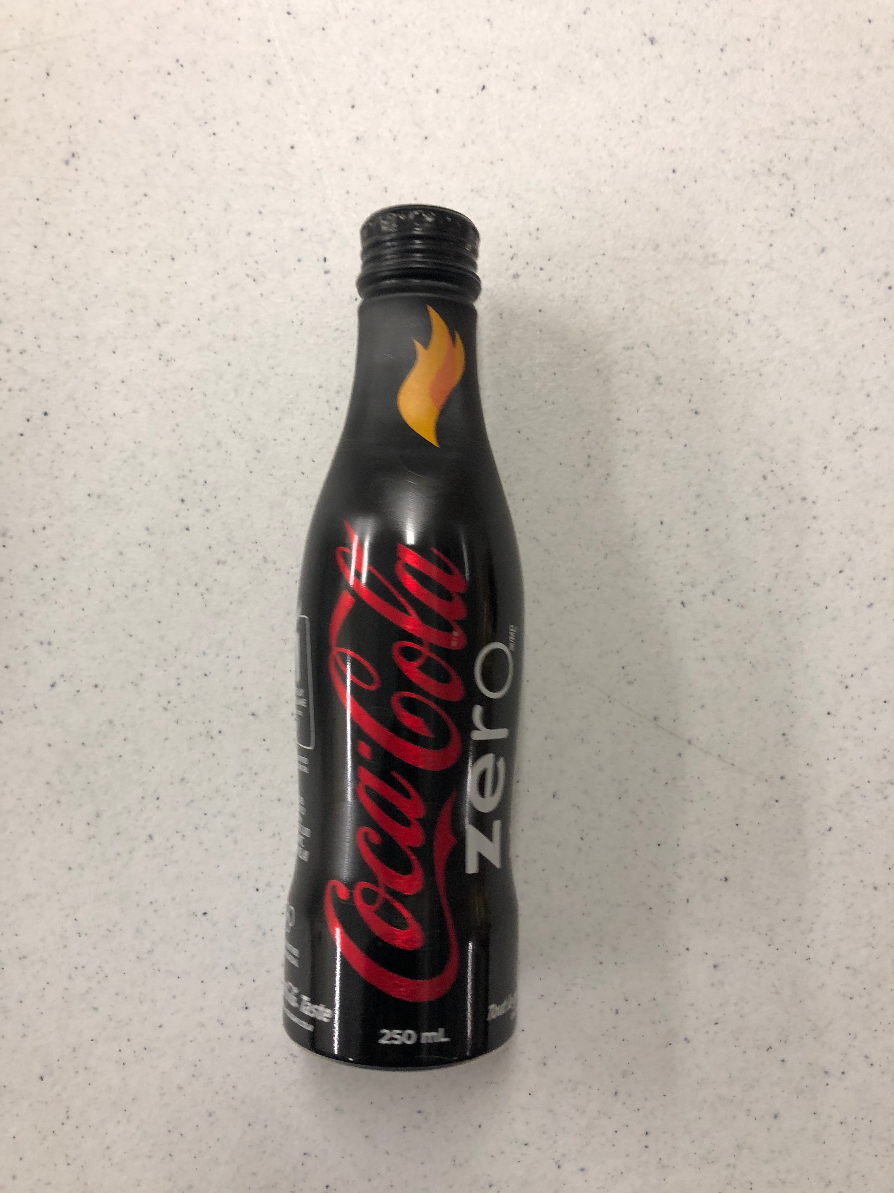
Bottle
https://search.heritageburnaby.ca/link/museumartifact90814
- Repository
- Burnaby Village Museum
- Accession Code
- BV020.40.5
- Description
- A matte black 250ml smooth glass bottle of Coca-cola. The liquid is still inside. The Coca-cola logo is in red, and "ZERO" is in white. There is a yellow and orange flame on the bottle neck. The lid is aluminum and still sealed.
- Object History
- This was a free giveaway from Coca-cola during the 2010 Olympic Torch Relay held in Burnaby's Cultural Complex.
- Classification
- Advertising Media
- Object Term
- Bottle, Sample
- Marks/Labels
- Coca-cola
- Colour
- Black
- White
- Red
- Yellow
- Measurements
- 8 inches high
- Maker
- Coca-cola
- Subjects
- Advertising Medium
- Beverages
- Events
- Historic Neighbourhood
- Burnaby Lake (Historic Neighbourhood)
- Planning Study Area
- Douglas-Gilpin Area
Images

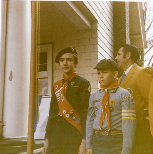
Boy Scouts at Heritage Village sod-turning
https://search.heritageburnaby.ca/link/museumdescription13661
- Repository
- Burnaby Village Museum
- Date
- 11 April 1971
- Collection/Fonds
- Donald Copan collection
- Description Level
- Item
- Physical Description
- 1 photograph : col. ; 10 x 10 cm
- Scope and Content
- Photograph of two Boy Scouts at the official sod-turning for Heritage Village (now Burnaby Village Museum), April 11, 1971. The Boy Scouts are standing next to a flag pole outside of Elworth house. A member of the Burnaby Centennial '71 Committee is standing behind them.
- Repository
- Burnaby Village Museum
- Collection/Fonds
- Donald Copan collection
- Series
- Copan album series
- Description Level
- Item
- Physical Description
- 1 photograph : col. ; 10 x 10 cm
- Scope and Content
- Photograph of two Boy Scouts at the official sod-turning for Heritage Village (now Burnaby Village Museum), April 11, 1971. The Boy Scouts are standing next to a flag pole outside of Elworth house. A member of the Burnaby Centennial '71 Committee is standing behind them.
- Subjects
- Buildings - Civic - Museums
- Celebrations - Centennials
- Organizations - Boys' Societies and Clubs
- Accession Code
- BV005.54.564
- Access Restriction
- No restrictions
- Reproduction Restriction
- May be restricted by third party rights
- Date
- 11 April 1971
- Media Type
- Photograph
- Historic Neighbourhood
- Burnaby Lake (Historic Neighbourhood)
- Planning Study Area
- Morley-Buckingham Area
- Scan Resolution
- 600
- Scan Date
- August 18, 2020
- Scale
- 100
- Notes
- Title based on contents of photograph
Images
![B.R. Hill house, [1910] thumbnail](/media/hpo/_Data/_BVM_Images/1976/1976_0051_0001_001.jpg?width=280)
B.R. Hill house
https://search.heritageburnaby.ca/link/museumdescription740
- Repository
- Burnaby Village Museum
- Date
- [1910]
- Collection/Fonds
- Burnaby Village Museum Photograph collection
- Description Level
- Item
- Physical Description
- 1 photograph : b&w photogravure ; 8.1 x 10.7 cm
- Scope and Content
- Photograph is photogravure printed on paper of a house on the side of a path. The area appears wooded. The inscription and the accession register identify the house as the residence of Mr. and Mrs. B.R. Hill on Douglas Road, built about 1892, with an addition to the house built about 1905.
- Repository
- Burnaby Village Museum
- Collection/Fonds
- Burnaby Village Museum Photograph collection
- Description Level
- Item
- Physical Description
- 1 photograph : b&w photogravure ; 8.1 x 10.7 cm
- Material Details
- An annotation in pencil is written on the back of the photograph
- Scope and Content
- Photograph is photogravure printed on paper of a house on the side of a path. The area appears wooded. The inscription and the accession register identify the house as the residence of Mr. and Mrs. B.R. Hill on Douglas Road, built about 1892, with an addition to the house built about 1905.
- Subjects
- Buildings - Residential - Houses
- Geographic Access
- Canada Way
- Douglas Road
- Street Address
- 4990 Canada Way
- Accession Code
- HV976.51.1
- Access Restriction
- No restrictions
- Reproduction Restriction
- May be restricted by third party rights
- Date
- [1910]
- Media Type
- Photograph
- Historic Neighbourhood
- Burnaby Lake (Historic Neighbourhood)
- Planning Study Area
- Douglas-Gilpin Area
- Scan Resolution
- 600
- Scan Date
- 2023-06-20
- Notes
- Title based on contents of photograph
Images
![B.R. Hill house, [1910] thumbnail](/media/hpo/_Data/_BVM_Images/1976/1976_0051_0001_001.jpg)
![Brookfield, [1900] thumbnail](/media/hpo/_Data/_BVM_Images/1976/1976_0139_0005_001.jpg?width=280)
Brookfield
https://search.heritageburnaby.ca/link/museumdescription754
- Repository
- Burnaby Village Museum
- Date
- [1900]
- Collection/Fonds
- Burnaby Village Museum Photograph collection
- Description Level
- Item
- Physical Description
- 1 photograph : b&w ; 9.9 x 14.0 cm mounted on cardboard 17.8 x 23.0 cm
- Scope and Content
- Photograph of "Brookfield", the first home of Mr. and Mrs. Louis Claude Hill. The Hills, including the daughter Kitty Hill, are on the lawn on the lower right corner. The man sitting on the steps is identified by the inscription on the photograph card mount as Mr. Wetenhall. Annotations on the back…
- Repository
- Burnaby Village Museum
- Collection/Fonds
- Burnaby Village Museum Photograph collection
- Description Level
- Item
- Physical Description
- 1 photograph : b&w ; 9.9 x 14.0 cm mounted on cardboard 17.8 x 23.0 cm
- Scope and Content
- Photograph of "Brookfield", the first home of Mr. and Mrs. Louis Claude Hill. The Hills, including the daughter Kitty Hill, are on the lawn on the lower right corner. The man sitting on the steps is identified by the inscription on the photograph card mount as Mr. Wetenhall. Annotations on the back of the card read: "'Brookfield' / Burnaby Lake" and "L.C. Hill & Kitty M. Hill, Mr. Wetenhall." Another annotation reads: "App. 1900."
- Subjects
- Buildings - Residential - Houses
- Geographic Access
- Deer Lake Avenue
- Street Address
- 6501 Deer Lake Avenue
- Accession Code
- HV976.139.5
- Access Restriction
- No restrictions
- Reproduction Restriction
- No known restrictions
- Date
- [1900]
- Media Type
- Photograph
- Historic Neighbourhood
- Burnaby Lake (Historic Neighbourhood)
- Planning Study Area
- Morley-Buckingham Area
- Related Material
- For another view of Brookfield home, see HV976.139.53
- Scan Resolution
- 600
- Scan Date
- 2023-06-27
- Notes
- Title based on contents of photograph
Images
![Brookfield, [1900] thumbnail](/media/hpo/_Data/_BVM_Images/1976/1976_0139_0005_001.jpg)

![Brookfield, [1896] thumbnail](/media/hpo/_Data/_BVM_Images/1973/1973_0040_0001_001.jpg?width=280)
Brookfield
https://search.heritageburnaby.ca/link/museumdescription988
- Repository
- Burnaby Village Museum
- Date
- [1896]
- Collection/Fonds
- Burnaby Village Museum Photograph collection
- Description Level
- Item
- Physical Description
- 1 photograph : b&w ; 12.1 x 17.7 cm
- Scope and Content
- Photograph of the house built about 1894 that Louis Claud Hill called "Brookfield." Mr. Hill was married that year to Annie Sara Kendrick, and they took up residence in the house until 1906 when they sold the property and built a new home in the vicinity of Buckingham and Sperling. Brookfield was…
- Repository
- Burnaby Village Museum
- Collection/Fonds
- Burnaby Village Museum Photograph collection
- Description Level
- Item
- Physical Description
- 1 photograph : b&w ; 12.1 x 17.7 cm
- Scope and Content
- Photograph of the house built about 1894 that Louis Claud Hill called "Brookfield." Mr. Hill was married that year to Annie Sara Kendrick, and they took up residence in the house until 1906 when they sold the property and built a new home in the vicinity of Buckingham and Sperling. Brookfield was still on the property when the Burnaby Village Museum was planned in 1971 as Heritage Village, but it was torn down to make room for other buildings on the site. An acquisition record notes that this house stood immediately behind the Elworth House, and Colonel Peers' (the donor) mother was born in this house in 1898. Annotations on the back of the photo read, "1896 'Brookfield'" and "The residence of Mr.+Mrs. LC Hill, the first residence on the site of Heritage Court. It stood immediately behind what is now called the Manor House. Built about 1894."
- Subjects
- Buildings - Residential - Houses
- Geographic Access
- Deer Lake Avenue
- Street Address
- 6501 Deer Lake Avenue
- Accession Code
- HV973.40.1
- Access Restriction
- No restrictions
- Reproduction Restriction
- No known restrictions
- Date
- [1896]
- Media Type
- Photograph
- Historic Neighbourhood
- Burnaby Lake (Historic Neighbourhood)
- Planning Study Area
- Morley-Buckingham Area
- Scan Resolution
- 600
- Scan Date
- 2023-05-09
- Scale
- 100
- Notes
- Title based on contents of photograph
Images
![Brookfield, [1896] thumbnail](/media/hpo/_Data/_BVM_Images/1973/1973_0040_0001_001.jpg)
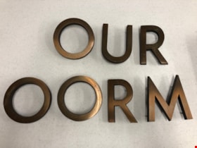
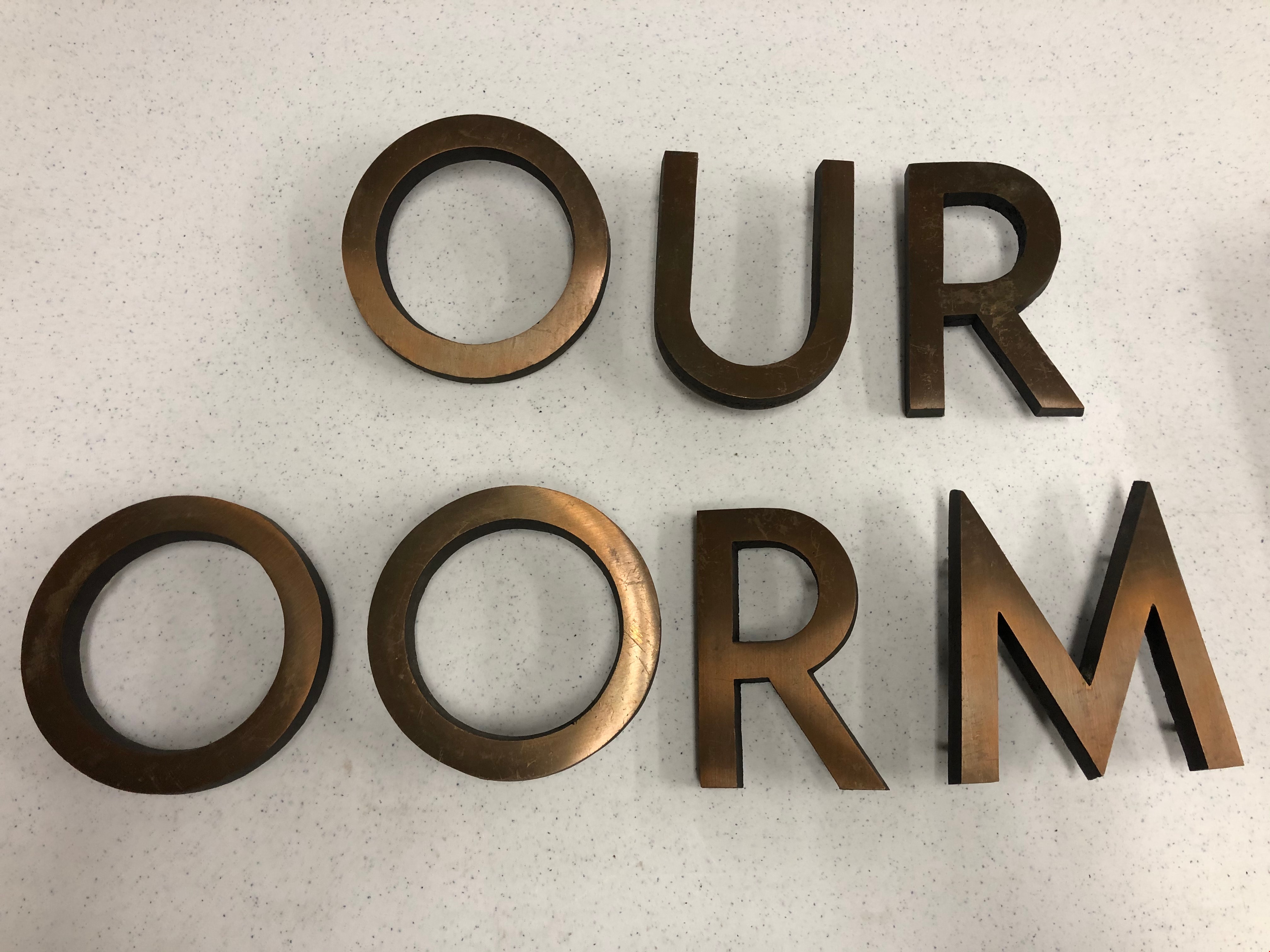
Building Letters
https://search.heritageburnaby.ca/link/museumartifact90803
- Repository
- Burnaby Village Museum
- Accession Code
- BV020.40.1
- Description
- Eight bronze capital letters: "OURT ROOM" Each letter has small protrusions on the backside where they were afixed to the exterior wall of Burnaby's Provincial courtroom.
- Object History
- The Court Room letters came from the 1965 Provincial Courthouse built adjacent to City Hall at 4949 Canada Way. This courtroom closed down in 2002.
- Object Term
- Sign, Identification
- Marks/Labels
- "OUR ROOM" is missing the C and the "T" to finish spelling courtroom.
- Colour
- Bronze
- Measurements
- 6" in height
- Subjects
- Building Components
- Buildings - Judicial - Courthouses
- Government - Provincial Government
- Officials - Judges
- Historic Neighbourhood
- Burnaby Lake (Historic Neighbourhood)
- Planning Study Area
- Douglas-Gilpin Area
Images

Buildings on Lubbock farm
https://search.heritageburnaby.ca/link/museumdescription12783
- Repository
- Burnaby Village Museum
- Date
- 1977
- Collection/Fonds
- Century Park Museum Association fonds
- Description Level
- Item
- Physical Description
- 1 photograph : col. slide ; 35 mm
- Scope and Content
- Photograph of the cedar shingled rooftops of the Lubbock barn and out buildings that were located at at 7803 Burris Street near Burnaby Lake. Bushes, trees and tall grasses surround the buildings.
- Repository
- Burnaby Village Museum
- Collection/Fonds
- Century Park Museum Association fonds
- Description Level
- Item
- Physical Description
- 1 photograph : col. slide ; 35 mm
- Scope and Content
- Photograph of the cedar shingled rooftops of the Lubbock barn and out buildings that were located at at 7803 Burris Street near Burnaby Lake. Bushes, trees and tall grasses surround the buildings.
- History
- In 1977, Century Park Museum was granted access to the Sprott-Lubbock farm to appraise the heritage buildings for preservation. Buildings that were saved included the old farrier shed (BV985.1240.2) which was also used as a blacksmith shop and the Vorce tram station building (BV985.1240.3) from the old Burnaby Lake Interurban line which was used as a grain storage shed on the property. Segments of the original farmhouse and other out buildings were retained. Other buildings on the site were demolished to make way for a new housing development.
- Subjects
- Agriculture - Farms
- Names
- Lubbock farm
- Geographic Access
- Grandview Highway
- Burris Street
- Street Address
- 7803 Burris Street
- Accession Code
- BV020.5.460
- Access Restriction
- No restrictions
- Reproduction Restriction
- No known restrictions
- Date
- 1977
- Media Type
- Photograph
- Historic Neighbourhood
- Burnaby Lake (Historic Neighbourhood)
- Planning Study Area
- Morley-Buckingham Area
- Scan Resolution
- 2400
- Scan Date
- 13-Mar-20
- Scale
- 100
- Notes
- Title based on contents of photograph
Images

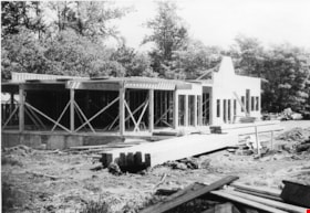
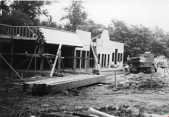
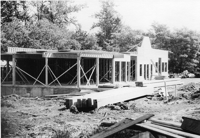
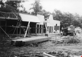
Buildings under construction in Heritage Village
https://search.heritageburnaby.ca/link/museumdescription13928
- Repository
- Burnaby Village Museum
- Date
- 1971
- Collection/Fonds
- Donald Copan collection
- Description Level
- Item
- Physical Description
- 1 photograph : b&w ; 8.8 x 12.5 cm
- Scope and Content
- Photograph of buildings under construction on what will be Hill Street inside Heritage Village.
- Repository
- Burnaby Village Museum
- Collection/Fonds
- Donald Copan collection
- Series
- Copan album series
- Description Level
- Item
- Physical Description
- 1 photograph : b&w ; 8.8 x 12.5 cm
- Scope and Content
- Photograph of buildings under construction on what will be Hill Street inside Heritage Village.
- Subjects
- Construction
- Names
- Burnaby Village Museum
- Accession Code
- BV005.54.818
- Access Restriction
- No restrictions
- Reproduction Restriction
- May be restricted by third party rights
- Date
- 1971
- Media Type
- Photograph
- Historic Neighbourhood
- Burnaby Lake (Historic Neighbourhood)
- Planning Study Area
- Morley-Buckingham Area
- Scan Resolution
- 600
- Scan Date
- 8-Sept-2020
- Scale
- 100
- Notes
- Title based on contents of photograph
Images
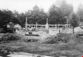
Buildings under construction in Heritage Village
https://search.heritageburnaby.ca/link/museumdescription13929
- Repository
- Burnaby Village Museum
- Date
- 1971
- Collection/Fonds
- Donald Copan collection
- Description Level
- Item
- Physical Description
- 1 photograph : b&w ; 8.8 x 12.5 cm
- Scope and Content
- Photograph of buildings under construction on what will be Hill Street inside Heritage Village.
- Repository
- Burnaby Village Museum
- Collection/Fonds
- Donald Copan collection
- Series
- Copan album series
- Description Level
- Item
- Physical Description
- 1 photograph : b&w ; 8.8 x 12.5 cm
- Scope and Content
- Photograph of buildings under construction on what will be Hill Street inside Heritage Village.
- Subjects
- Construction
- Names
- Burnaby Village Museum
- Accession Code
- BV005.54.819
- Access Restriction
- No restrictions
- Reproduction Restriction
- May be restricted by third party rights
- Date
- 1971
- Media Type
- Photograph
- Historic Neighbourhood
- Burnaby Lake (Historic Neighbourhood)
- Planning Study Area
- Morley-Buckingham Area
- Scan Resolution
- 600
- Scan Date
- 8-Sept-2020
- Scale
- 100
- Notes
- Title based on contents of photograph
Images
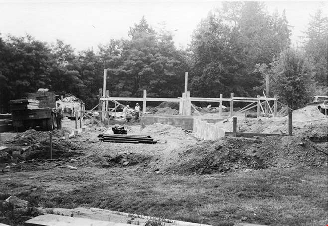
Buildings under construction in Heritage Village
https://search.heritageburnaby.ca/link/museumdescription13930
- Repository
- Burnaby Village Museum
- Date
- 1971
- Collection/Fonds
- Donald Copan collection
- Description Level
- Item
- Physical Description
- 1 photograph : b&w ; 8.8 x 12.5 cm
- Scope and Content
- Photograph of buildings under construction on what will be Hill Street inside Heritage Village.
- Repository
- Burnaby Village Museum
- Collection/Fonds
- Donald Copan collection
- Series
- Copan album series
- Description Level
- Item
- Physical Description
- 1 photograph : b&w ; 8.8 x 12.5 cm
- Scope and Content
- Photograph of buildings under construction on what will be Hill Street inside Heritage Village.
- Subjects
- Construction
- Names
- Burnaby Village Museum
- Accession Code
- BV005.54.820
- Access Restriction
- No restrictions
- Reproduction Restriction
- May be restricted by third party rights
- Date
- 1971
- Media Type
- Photograph
- Historic Neighbourhood
- Burnaby Lake (Historic Neighbourhood)
- Planning Study Area
- Morley-Buckingham Area
- Scan Resolution
- 600
- Scan Date
- 8-Sept-2020
- Scale
- 100
- Notes
- Title based on contents of photograph
Images