![Learning to Ride a Bike, [1904] thumbnail](/media/hpo/_Data/_Archives_Images/_Unrestricted/477/477-146.jpg?width=280)
Learning to Ride a Bike
https://search.heritageburnaby.ca/link/archivedescription38827
- Repository
- City of Burnaby Archives
- Date
- [1904]
- Collection/Fonds
- Peers Family and Hill Family fonds
- Description Level
- Item
- Physical Description
- 1 photograph : b&w ; 5.7 x 8.2 cm on page 11.5 x 14 cm (pasted in album)
- Scope and Content
- Photograph shows a young girl (probably Kitty Hill) being helped to ride a bicycle by Claude Hill, Kitty's father. The girl standing in the background is unidentified. Photograph appears to have been taken at the Hill family home, Brookfield, in the Burnaby Lake area.
- Repository
- City of Burnaby Archives
- Date
- [1904]
- Collection/Fonds
- Peers Family and Hill Family fonds
- Physical Description
- 1 photograph : b&w ; 5.7 x 8.2 cm on page 11.5 x 14 cm (pasted in album)
- Description Level
- Item
- Record No.
- 477-146
- Access Restriction
- No restrictions
- Reproduction Restriction
- No known restrictions
- Accession Number
- 2007-12
- Scope and Content
- Photograph shows a young girl (probably Kitty Hill) being helped to ride a bicycle by Claude Hill, Kitty's father. The girl standing in the background is unidentified. Photograph appears to have been taken at the Hill family home, Brookfield, in the Burnaby Lake area.
- Subjects
- Transportation - Bicycles
- Media Type
- Photograph
- Notes
- Title based on contents of photograph
- Geographic Access
- Deer Lake Avenue
- Street Address
- 6501 Deer Lake Avenue
- Historic Neighbourhood
- Burnaby Lake (Historic Neighbourhood)
- Planning Study Area
- Morley-Buckingham Area
Images
![Learning to Ride a Bike, [1904] thumbnail](/media/hpo/_Data/_Archives_Images/_Unrestricted/477/477-146.jpg)
![Looking down north Poleline Hill, [1908] thumbnail](/media/hpo/_Data/_BVM_Images/1976/1976_0139_0047_001.jpg?width=280)
Looking down north Poleline Hill
https://search.heritageburnaby.ca/link/museumdescription796
- Repository
- Burnaby Village Museum
- Date
- [1908]
- Collection/Fonds
- Burnaby Village Museum Photograph collection
- Description Level
- Item
- Physical Description
- 1 photograph : b&w ; 20.32 x 25.4 cm print
- Scope and Content
- Photograph looking north along the Pole Line Road (later Sperling Avenue). To the far left is Deer Lake and at the top right is Burnaby Lake. The smoke and debris from land clearing is a result of logging operations being carried out by the Doran Brothers logging company, the Deer Lake Mill Company…
- Repository
- Burnaby Village Museum
- Collection/Fonds
- Burnaby Village Museum Photograph collection
- Description Level
- Item
- Physical Description
- 1 photograph : b&w ; 20.32 x 25.4 cm print
- Material Details
- inscribed in pencil, verso, l.l. "Looking down north Poleline Hill (now Sperling) Deer Lake at left. "
- Scope and Content
- Photograph looking north along the Pole Line Road (later Sperling Avenue). To the far left is Deer Lake and at the top right is Burnaby Lake. The smoke and debris from land clearing is a result of logging operations being carried out by the Doran Brothers logging company, the Deer Lake Mill Company. Above Deer Lake, Douglas Road is visible with Claude Hill's Brookfield property (later 6501 Deer Lake Avenue) on the south side of the road and Bernard Hill's home on the north side (later 4990 Canada Way). Just northeast of Brookfield is the George Every-Clayton farm (amongst the trees) on what would later become the Henry and Grace Ceperley estate grounds known as Fairacres. The house in the centre of the picture is the Walker house (later 5255 Sperling Avenue). Mountains can be seen to the north.
- Subjects
- Land Clearing
- Geographic Features - Roads
- Industries - Forestry
- Industries - Logging/lumber
- Geographic Access
- Sperling Avenue
- Deer Lake
- Douglas Road
- Canada Way
- Accession Code
- HV976.139.47
- Access Restriction
- No restrictions
- Reproduction Restriction
- No known restrictions
- Date
- [1908]
- Media Type
- Photograph
- Historic Neighbourhood
- Burnaby Lake (Historic Neighbourhood)
- Planning Study Area
- Morley-Buckingham Area
- Scan Resolution
- 600
- Scan Date
- 2023-06-27
- Notes
- Title based on contents of photograph
Images
![Looking down north Poleline Hill, [1908] thumbnail](/media/hpo/_Data/_BVM_Images/1976/1976_0139_0047_001.jpg)
![Looking east from 5493 Dominion Street, [between 1965 and 1969] thumbnail](/media/hpo/_Data/_Archives_Images/_Unrestricted/600/620-023.jpg?width=280)
Looking east from 5493 Dominion Street
https://search.heritageburnaby.ca/link/archivedescription91842
- Repository
- City of Burnaby Archives
- Date
- [between 1965 and 1969]
- Collection/Fonds
- Small family fonds
- Description Level
- Item
- Physical Description
- 1 photograph : b&w copy print ; 12 cm x 12 cm
- Scope and Content
- Photograph of the Hardy family's house located at 3093 Douglas Road. The photograph was taken from 5493 (previously 3107) Dominion Street, looking east.
- Repository
- City of Burnaby Archives
- Date
- [between 1965 and 1969]
- Collection/Fonds
- Small family fonds
- Physical Description
- 1 photograph : b&w copy print ; 12 cm x 12 cm
- Description Level
- Item
- Record No.
- 620-023
- Access Restriction
- No restrictions
- Reproduction Restriction
- No reproduction permitted
- Accession Number
- 2017-01
- Scope and Content
- Photograph of the Hardy family's house located at 3093 Douglas Road. The photograph was taken from 5493 (previously 3107) Dominion Street, looking east.
- Subjects
- Buildings - Residential - Houses
- Media Type
- Photograph
- Notes
- Transcribed title
- Title transcribed from donor's notes
- Note in blue ink on verso of photograph reads: "3093 Douglas Rd / "The Hardy's house""
- Note in blue ink on verso of photograph reads: "P.23"
- Note in blue ink on verso of photograph reads: "Photo courtesy of [name]"
- Street Address
- 3093 Douglas Road
- Historic Neighbourhood
- Burnaby Lake (Historic Neighbourhood)
- Planning Study Area
- Ardingley-Sprott Area
Images
![Looking east from 5493 Dominion Street, [between 1965 and 1969] thumbnail](/media/hpo/_Data/_Archives_Images/_Unrestricted/600/620-023.jpg)
![Looking north from 5486 Dominion Street, [between 1960 and 1965] thumbnail](/media/hpo/_Data/_Archives_Images/_Unrestricted/600/620-029.jpg?width=280)
Looking north from 5486 Dominion Street
https://search.heritageburnaby.ca/link/archivedescription91848
- Repository
- City of Burnaby Archives
- Date
- [between 1960 and 1965]
- Collection/Fonds
- Small family fonds
- Description Level
- Item
- Physical Description
- 1 photograph : b&w copy print ; 5.5 cm x 15 cm on paper 10 cm x 15 cm
- Scope and Content
- Photograph of the Beech family's house under construction next door to the McLeans' house at 5493 Dominion Street. The McLeans sold the lot to the west of their house to the Beeches and the mushroom barns which were previously located on the lot were demolished. The photograph was taken from 5486…
- Repository
- City of Burnaby Archives
- Date
- [between 1960 and 1965]
- Collection/Fonds
- Small family fonds
- Physical Description
- 1 photograph : b&w copy print ; 5.5 cm x 15 cm on paper 10 cm x 15 cm
- Description Level
- Item
- Record No.
- 620-029
- Access Restriction
- No restrictions
- Reproduction Restriction
- No reproduction permitted
- Accession Number
- 2017-01
- Scope and Content
- Photograph of the Beech family's house under construction next door to the McLeans' house at 5493 Dominion Street. The McLeans sold the lot to the west of their house to the Beeches and the mushroom barns which were previously located on the lot were demolished. The photograph was taken from 5486 Dominion Street, looking north.
- Media Type
- Photograph
- Notes
- Transcribed title
- Title transcribed from donor's notes
- Note in blue ink on verso of photograph reads: "P.29"
- Note in blue ink on verso of photograph reads: "Probably 1960 / Beech's House under construction / Copy from a negative"
- 5493 Dominion Street was previously numbered 3107 Dominion Street and was later subdivided into two lots: 5491 and 5495 Dominion Street.
- Lot address for the Beechs' house is unconfirmed, but likely 5473 Dominion Street (later subdivided into 5473 and 5483 Dominion Street)
- Street Address
- 5493 Dominion Street
- 3107 Dominion Street
- Historic Neighbourhood
- Burnaby Lake (Historic Neighbourhood)
- Planning Study Area
- Ardingley-Sprott Area
Images
![Looking north from 5486 Dominion Street, [between 1960 and 1965] thumbnail](/media/hpo/_Data/_Archives_Images/_Unrestricted/600/620-029.jpg)
![Looking north from 5486 Dominion Street, [between 1965 and 1966] thumbnail](/media/hpo/_Data/_Archives_Images/_Unrestricted/600/620-030.jpg?width=280)
Looking north from 5486 Dominion Street
https://search.heritageburnaby.ca/link/archivedescription91849
- Repository
- City of Burnaby Archives
- Date
- [between 1965 and 1966]
- Collection/Fonds
- Small family fonds
- Description Level
- Item
- Physical Description
- 1 photograph : b&w ; 9 cm x 9.5 cm
- Scope and Content
- Photograph of the McLeans' house at 5493 Dominion Street (left) and the Brocklebank's house at 3071 Douglas Road (right). The photograph is taken from 5486 Dominion Street, looking north.
- Repository
- City of Burnaby Archives
- Date
- [between 1965 and 1966]
- Collection/Fonds
- Small family fonds
- Physical Description
- 1 photograph : b&w ; 9 cm x 9.5 cm
- Description Level
- Item
- Record No.
- 620-030
- Access Restriction
- No restrictions
- Reproduction Restriction
- No reproduction permitted
- Accession Number
- 2017-01
- Scope and Content
- Photograph of the McLeans' house at 5493 Dominion Street (left) and the Brocklebank's house at 3071 Douglas Road (right). The photograph is taken from 5486 Dominion Street, looking north.
- Subjects
- Buildings - Residential - Houses
- Media Type
- Photograph
- Notes
- Transcribed title
- Title transcribed from donor's notes
- Note in blue ink on verso of photograph reads: "P.30"
- Note in blue ink on verso of photograph reads: "McLean's, Kamberg's, Brocklebank's houses. / Prob. 1965 or '66"
- 5493 Dominion Street was previously numbered 3107 Dominion Street and was later subdivided into two lots: 5491 and 5495 Dominion Street.
- Street Address
- 3071 Douglas Road
- 5493 Dominion Street
- Historic Neighbourhood
- Burnaby Lake (Historic Neighbourhood)
- Planning Study Area
- Ardingley-Sprott Area
Images
![Looking north from 5486 Dominion Street, [between 1965 and 1966] thumbnail](/media/hpo/_Data/_Archives_Images/_Unrestricted/600/620-030.jpg)
![Looking north from 5486 Dominion Street, [1969] thumbnail](/media/hpo/_Data/_Archives_Images/_Unrestricted/600/620-031.jpg?width=280)
Looking north from 5486 Dominion Street
https://search.heritageburnaby.ca/link/archivedescription91850
- Repository
- City of Burnaby Archives
- Date
- [1969]
- Collection/Fonds
- Small family fonds
- Description Level
- Item
- Physical Description
- 1 photograph : b&w ; 9 cm x 12 cm
- Scope and Content
- Photograph of the McLeans' house at 5493 Dominion Street with a Volkswagon Beetle parked on the street in front. The Brocklebanks's backyard at 3071 Douglas Road is visible on the right. The photograph was taken from 5486 Dominion Street, looking north.
- Repository
- City of Burnaby Archives
- Date
- [1969]
- Collection/Fonds
- Small family fonds
- Physical Description
- 1 photograph : b&w ; 9 cm x 12 cm
- Description Level
- Item
- Record No.
- 620-031
- Access Restriction
- No restrictions
- Reproduction Restriction
- No reproduction permitted
- Accession Number
- 2017-01
- Scope and Content
- Photograph of the McLeans' house at 5493 Dominion Street with a Volkswagon Beetle parked on the street in front. The Brocklebanks's backyard at 3071 Douglas Road is visible on the right. The photograph was taken from 5486 Dominion Street, looking north.
- Media Type
- Photograph
- Notes
- Transcribed title
- Title transcribed from donor's notes
- Note in blue ink on verso of photograph reads: "P.31"
- Note in blue ink on verso of photograph reads: "(McLean's) / 5493 Domion [sic] St (left) (3071 Douglas Rd / Brocklebanks back yard / (right)"
- Note in blue ink of verso of photograph reads: "?-11-69 probably ?"
- 5493 Dominion Street was previously numbered 3107 Dominion Street and was later subdivided into two lots: 5491 and 5495 Dominion Street.
- Photograph 620-032 was taken from the same vantage point
- Street Address
- 3071 Douglas Road
- 5493 Dominion Street
- Historic Neighbourhood
- Burnaby Lake (Historic Neighbourhood)
- Planning Study Area
- Ardingley-Sprott Area
Images
![Looking north from 5486 Dominion Street, [1969] thumbnail](/media/hpo/_Data/_Archives_Images/_Unrestricted/600/620-031.jpg)
![Looking southeast from 5118 Douglas Road - The Roberts House, [between 1960 and 1975] thumbnail](/media/hpo/_Data/_Archives_Images/_Unrestricted/600/620-011.jpg?width=280)
Looking southeast from 5118 Douglas Road - The Roberts House
https://search.heritageburnaby.ca/link/archivedescription91830
- Repository
- City of Burnaby Archives
- Date
- [between 1960 and 1975]
- Collection/Fonds
- Small family fonds
- Description Level
- Item
- Physical Description
- 1 photograph : b&w ; 12.5 cm x 9 cm
- Scope and Content
- Photograph of the Manahan family's house, taken from 5118 Douglas Road, looking southeast. In the 1960s the Meyers sold a portion of their property at to the Manahan family and the house in the centre of the photograph was built. The address of the house is unknown. To the right, the Meyers' hou…
- Repository
- City of Burnaby Archives
- Date
- [between 1960 and 1975]
- Collection/Fonds
- Small family fonds
- Physical Description
- 1 photograph : b&w ; 12.5 cm x 9 cm
- Description Level
- Item
- Record No.
- 620-011
- Access Restriction
- No restrictions
- Reproduction Restriction
- No reproduction permitted
- Accession Number
- 2017-01
- Scope and Content
- Photograph of the Manahan family's house, taken from 5118 Douglas Road, looking southeast. In the 1960s the Meyers sold a portion of their property at to the Manahan family and the house in the centre of the photograph was built. The address of the house is unknown. To the right, the Meyers' house is partially visible.
- Subjects
- Buildings - Residential - Houses
- Media Type
- Photograph
- Notes
- Transcribed title
- Title transcribed from donor's notes
- 5106 Douglas Road later subdivided into 5539 and 5545 Norfolk Street
- Note in blue ink on verso of photograph reads: "(Meyers House on Right)"
- Note in blue ink on verso of photograph reads: "P11"
- Note in blue ink on verso of photograph reads: "Manahan's House"
- Note in blue ink on verso of photograph reads: "1960's or early 1970s"
- Street Address
- 5106 Douglas Road
- Historic Neighbourhood
- Burnaby Lake (Historic Neighbourhood)
- Planning Study Area
- Ardingley-Sprott Area
Images
![Looking southeast from 5118 Douglas Road - The Roberts House, [between 1960 and 1975] thumbnail](/media/hpo/_Data/_Archives_Images/_Unrestricted/600/620-011.jpg)

Looking south from Bernard Hill's house
https://search.heritageburnaby.ca/link/archivedescription39527
- Repository
- City of Burnaby Archives
- Date
- 1906
- Collection/Fonds
- Peers Family and Hill Family fonds
- Description Level
- Item
- Physical Description
- 1 photograph : b&w ; 11.8 x 17 cm on page 21.5 x 28 cm (pasted in album)
- Scope and Content
- Photograph of the fields and farmland looking southeast from the home of Bernard Hill down Douglas Road towards Deer Lake Brook. In the foreground view can be seen what is the present-day Kensington Avenue freeway entrance and No. 1 Firehall site on Sperling Avenue. The cabin that can be seen to …
- Repository
- City of Burnaby Archives
- Date
- 1906
- Collection/Fonds
- Peers Family and Hill Family fonds
- Physical Description
- 1 photograph : b&w ; 11.8 x 17 cm on page 21.5 x 28 cm (pasted in album)
- Description Level
- Item
- Record No.
- 477-846
- Access Restriction
- No restrictions
- Reproduction Restriction
- No known restrictions
- Accession Number
- 2007-12
- Scope and Content
- Photograph of the fields and farmland looking southeast from the home of Bernard Hill down Douglas Road towards Deer Lake Brook. In the foreground view can be seen what is the present-day Kensington Avenue freeway entrance and No. 1 Firehall site on Sperling Avenue. The cabin that can be seen to the left in the background is an unknown residence further along Douglas Road near Rayside Drive and the cabin that is just visible in the centre background of the photograph (between treeline split) belonged to Mr. Nicholson. It was later torn down when Bernard Hill's brother Claude Hill built his home, Broadview at that location. To the extreme right of the picture on the opposite side of Douglas Road is the property of Claude Hill's first Burnaby home also known as Brookfield (the current location of the Burnaby Village Museum).
- Subjects
- Agriculture - Farms
- Media Type
- Photograph
- Notes
- Title based on caption accompanying photograph
- Geographic Access
- Douglas Road
- Canada Way
- Deer Lake Brook
- Street Address
- 4990 Canada Way
- Historic Neighbourhood
- Burnaby Lake (Historic Neighbourhood)
- Planning Study Area
- Douglas-Gilpin Area
Images

Looking west from back yard of 5486 Dominion Street
https://search.heritageburnaby.ca/link/archivedescription91869
- Repository
- City of Burnaby Archives
- Date
- 1961
- Collection/Fonds
- Small family fonds
- Description Level
- Item
- Physical Description
- 1 photograph : sepia ; 8 cm x 6.5 cm
- Scope and Content
- Photograph of Martin and Charles Shaw playing the backyard at 5486 Dominion Street. The house at 5466 Dominion Street, which likely predates the Roberts' house, is visible in the background. The photograph was taken from the backyard of 5486 Dominion Street, looking west.
- Repository
- City of Burnaby Archives
- Date
- 1961
- Collection/Fonds
- Small family fonds
- Physical Description
- 1 photograph : sepia ; 8 cm x 6.5 cm
- Description Level
- Item
- Record No.
- 620-050
- Access Restriction
- No restrictions
- Reproduction Restriction
- No reproduction permitted
- Accession Number
- 2017-01
- Scope and Content
- Photograph of Martin and Charles Shaw playing the backyard at 5486 Dominion Street. The house at 5466 Dominion Street, which likely predates the Roberts' house, is visible in the background. The photograph was taken from the backyard of 5486 Dominion Street, looking west.
- Media Type
- Photograph
- Notes
- Transcribed title
- Title transcribed from donor's notes
- Note in blue ink on verso of photograph reads: "P12"
- Note in blue ink on verso of photograph reads: "Charles 7 / Martin 5"
- Note in blue ink on verso of photograph reads: "Between March and Jun 1961"
- 5486 Dominion Street later subdivided into two lots: 5480 and 5488 Dominion Street
- 5466 Dominion Street later subdivided into two lots: 5462 and 5468 Dominion Street
- Street Address
- 5466 Dominion Street
- 5486 Dominion Street
- Historic Neighbourhood
- Burnaby Lake (Historic Neighbourhood)
- Planning Study Area
- Ardingley-Sprott Area
Images


Looking west from Douglas Road
https://search.heritageburnaby.ca/link/archivedescription91832
- Repository
- City of Burnaby Archives
- Date
- 1969
- Collection/Fonds
- Small family fonds
- Description Level
- Item
- Physical Description
- 1 photograph : b&w ; 9 cm x 12.5 cm
- Scope and Content
- Photograph of Roberts' house and front lawn at 3131 Douglas Road (previously 5118 Douglas Road). The photograph was taken from Douglas Road, looking west.
- Repository
- City of Burnaby Archives
- Date
- 1969
- Collection/Fonds
- Small family fonds
- Physical Description
- 1 photograph : b&w ; 9 cm x 12.5 cm
- Description Level
- Item
- Record No.
- 620-013
- Access Restriction
- No restrictions
- Reproduction Restriction
- No reproduction permitted
- Accession Number
- 2017-01
- Scope and Content
- Photograph of Roberts' house and front lawn at 3131 Douglas Road (previously 5118 Douglas Road). The photograph was taken from Douglas Road, looking west.
- Subjects
- Buildings - Residential - Houses
- Media Type
- Photograph
- Notes
- Transcribed title
- Title transcribed from donor's notes
- Note in black ink on verso of photograph reads: "1969 / Roberts' house and front lawn"
- Note in blue ink on verso of photograph reads: "P.13"
- Stamp in black ink on verso of photograph reads: "11.8.69"
- 5118 Douglas Road renumbered to 3131 Douglas Road in 1958 and to 5538 Dominion Street in 1970 or 1971
- Street Address
- 3131 Douglas Road
- 5118 Douglas Road
- 5538 Dominion Street
- Historic Neighbourhood
- Burnaby Lake (Historic Neighbourhood)
- Planning Study Area
- Ardingley-Sprott Area
Images
![Louis Claude Hill's Farm, Burnaby, BC, [1909] thumbnail](/media/hpo/_Data/_BVM_Images/1973/1973_0040_0004_001.jpg?width=280)
Louis Claude Hill's Farm, Burnaby, BC
https://search.heritageburnaby.ca/link/museumdescription3064
- Repository
- Burnaby Village Museum
- Date
- [1909]
- Collection/Fonds
- Burnaby Village Museum Photograph collection
- Description Level
- Item
- Physical Description
- 1 photograph : b&w ; 12.2 x 17.6 cm mounted on cardboard 22.7 x 27.4 cm
- Scope and Content
- Photograph of a farm with men, a horse and wagon, and children in a field. An annotation on the back of one of the photos reads, "The foreground farm property stood at the corner of Sperling Avenue (formerly known as the Pole Line Road) and Buckingham. The white house in the left centre was the …
- Repository
- Burnaby Village Museum
- Collection/Fonds
- Burnaby Village Museum Photograph collection
- Description Level
- Item
- Physical Description
- 1 photograph : b&w ; 12.2 x 17.6 cm mounted on cardboard 22.7 x 27.4 cm
- Scope and Content
- Photograph of a farm with men, a horse and wagon, and children in a field. An annotation on the back of one of the photos reads, "The foreground farm property stood at the corner of Sperling Avenue (formerly known as the Pole Line Road) and Buckingham. The white house in the left centre was the residence of Miss Woodward, her mother and sister. It was the first post office at 'Burnaby Lake' and the site of the kindergarten school of Miss Harriet Woodward. It later became the United Church. / The open field in the distance above the horse's head and people in the field is the field in front of the 'Manor House' which was built by Mr. Bateman in the 1920's. To the right of and beyond the white house partly hidden by the trees can be seen some of the buildings associated with the Hill farm on Deer Lake Ave. which by the date (1909) of this photo had been sold. The distant tall trees (center) stand on the site of the Municipal Buildings (DesBirsays Woods)." An annotation on the back of the other photograph reads, "Formerly belonging to Malcom Nicolson / App. 1908." Annotations at the bottom front of the photograph read, "L. Claude Hill's Farm, Burnaby, BC."
- Subjects
- Agriculture - Crops
- Agricultural Tools and Equipment
- Animals - Horses
- Occupations - Farmers
- Agriculture - Farms
- Geographic Access
- Buckingham Avenue
- Sperling Avenue
- Accession Code
- HV973.40.4
- Access Restriction
- No restrictions
- Reproduction Restriction
- No known restrictions
- Date
- [1909]
- Media Type
- Photograph
- Historic Neighbourhood
- Burnaby Lake (Historic Neighbourhood)
- Planning Study Area
- Morley-Buckingham Area
- Scan Resolution
- 600
- Scan Date
- 2023-05-09
- Scale
- 100
- Notes
- Title based on contents of photograph
- 1 b&w duplicate photograph accompanying
- Text on first image "L Claude Hill's Farm, Burnaby B C", incorporated into the image at the bottom edge of the photograph. "app 1909" pencilled in following above on the bottom edge of the image "L. Claude / Hill / Broadview", pencilled on the matt below the image. "The foreground farm property stood at the / Corner of Sperling Ave. (formerly known as Pole Line Road) / and Buckingham. The white house in the left / centre was the residence of Miss Woodward, her mother / and sister. It was the first post ofice at "Burnaby Lake" / and the site of the kindergarten school of Miss / Harriet Woodward. It later became the United / Church. / The open field in the distance above / the horses head and people in the field is / the field in front of the "Manse House" which / was built by Mr. Bateman in the 1920's. To the / right of and beyond the white house partly hidden / by the trees can be seen some of the buildings / associated with the Hill farm on Deer Lake Ave. / which by the date (1909) of this photo had been / sold. The distant tall trees (center) stand on the site of / the Municipal Buildings (DesBirsays Woods)", hand written in blue ink on the reverse side of the matt. It is not indicated who wrote the note. "OR MASTER / 973.40.4", pencilled in the lower right corner of reverse side of matt. "W. T. COOKSLEY / NEW WESTMINSTER, B.C."printed with very little contrast on the gray mattboard, below the lower right corner of the photograph Text on second image. "L Claude Hill's Farm, Burnaby B C", incorporated into the image at the bottom edge of the photograph. "Claude surveying the haying", pencilled on the reverse side of the matt. "Formerly belonging to Malcolm Nicholson / app 1908", hand writen in blue ink on the reverse side of the matt. "H.V.973.40.4. OR. MASTER", hand printed on the bottom left corner of the reverse side of the matt. "W. T. COOKSLEY / NEW WESTMINSTER, B.C."printed with very little contrast on the gray mattboard, below the lower right corner of the photograph
Images
![Louis Claude Hill's Farm, Burnaby, BC, [1909] thumbnail](/media/hpo/_Data/_BVM_Images/1973/1973_0040_0004_001.jpg)


Louis Claude Hill's Strawberry Farm, Burnaby BC
https://search.heritageburnaby.ca/link/museumdescription991
- Repository
- Burnaby Village Museum
- Date
- 1902
- Collection/Fonds
- Burnaby Village Museum Photograph collection
- Description Level
- Item
- Physical Description
- 1 photograph : sepia ; 12.8 x 17.7 cm mounted on grey card 15.0 x 20.0 cm
- Scope and Content
- Photograph of immigrant workers in the field picking strawberries on the farm belonging to Claude Hill. On the left, the Hill family home, Brookfield, can be seen. Claude Hill's daughter, Kitty Hill, is sitting on the steps of the house. The property is the current site of the Burnaby Village Muse…
- Repository
- Burnaby Village Museum
- Collection/Fonds
- Burnaby Village Museum Photograph collection
- Description Level
- Item
- Physical Description
- 1 photograph : sepia ; 12.8 x 17.7 cm mounted on grey card 15.0 x 20.0 cm
- Scope and Content
- Photograph of immigrant workers in the field picking strawberries on the farm belonging to Claude Hill. On the left, the Hill family home, Brookfield, can be seen. Claude Hill's daughter, Kitty Hill, is sitting on the steps of the house. The property is the current site of the Burnaby Village Museum.
- Subjects
- Agriculture - Farms
- Occupations - Agricultural Labourers
- Agriculture - Fruit and Berries
- Buildings - Residential - Houses
- Persons - Chinese Canadians
- Accession Code
- HV973.40.5
- Access Restriction
- No restrictions
- Reproduction Restriction
- No known restrictions
- Date
- 1902
- Media Type
- Photograph
- Historic Neighbourhood
- Burnaby Lake (Historic Neighbourhood)
- Planning Study Area
- Morley-Buckingham Area
- Scan Resolution
- 600
- Scan Date
- 2023-05-09
- Scale
- 100
- Photographer
- Cooksley, William Thomas
- Notes
- Title based on caption accompanying photograph
- Inscribed on the negative and (therefore) printed on recto of photograph reads: "L.C. Hill's Strawberry Farm, Burnaby, B.C." and "W.T. Cooksley, New Westminster, B.C."
- Note written in red pencil on the card reads: "1902 - Grandview H.WAY"
Images


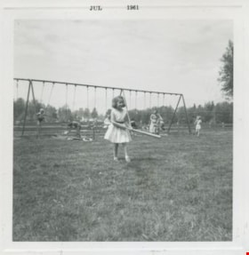
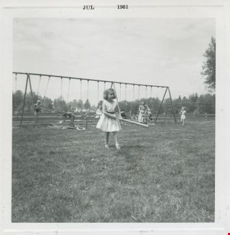
Louise Emmonds at Deer lake
https://search.heritageburnaby.ca/link/archivedescription52979
- Repository
- City of Burnaby Archives
- Date
- July 1961
- Collection/Fonds
- Burnaby Historical Society fonds
- Description Level
- Item
- Physical Description
- 1 photograph : b&w ; 7.5 x 7.5 cm, mounted on heavy-weight paper 17.5 x 27.5 cm
- Scope and Content
- Photograph of Louise Emmonds swinging a bat at Dear lake. She is wearing a white dress with a black belt. Children can be seen swinging on a large swing set (with the help of adults) in the background.
- Repository
- City of Burnaby Archives
- Date
- July 1961
- Collection/Fonds
- Burnaby Historical Society fonds
- Subseries
- Tinkerbell Kindergarten subseries
- Physical Description
- 1 photograph : b&w ; 7.5 x 7.5 cm, mounted on heavy-weight paper 17.5 x 27.5 cm
- Description Level
- Item
- Record No.
- 246-019
- Access Restriction
- No restrictions
- Reproduction Restriction
- Reproduce for fair dealing purposes only
- Accession Number
- BHS1990-12
- Scope and Content
- Photograph of Louise Emmonds swinging a bat at Dear lake. She is wearing a white dress with a black belt. Children can be seen swinging on a large swing set (with the help of adults) in the background.
- Media Type
- Photograph
- Notes
- Title based on contents of photograph
- Handwritten note on paper mount reads: "Deer Lake / 1960 - 1961 / mis [sic] Louise Emmonds"
- Geographic Access
- Deer Lake
- Deer Lake Park
- Deer Lake Avenue
- Historic Neighbourhood
- Burnaby Lake (Historic Neighbourhood)
- Planning Study Area
- Douglas-Gilpin Area
Images
Lubbock photographs from album
https://search.heritageburnaby.ca/link/archivedescription64493
- Repository
- City of Burnaby Archives
- Date
- 1945-1988
- Collection/Fonds
- Burnaby Historical Society fonds
- Description Level
- File
- Physical Description
- 130 photographs : b&w and col. ; 20.5 x 25.5 cm or smaller
- Scope and Content
- Photographs of the Lubbock family, including their riding stables and horses, family events, their pets, and landscape and travel photographs. These photographs were originally housed in a photographic album.
- Repository
- City of Burnaby Archives
- Date
- 1945-1988
- Collection/Fonds
- Burnaby Historical Society fonds
- Subseries
- Lubbock family subseries
- Physical Description
- 130 photographs : b&w and col. ; 20.5 x 25.5 cm or smaller
- Description Level
- File
- Record No.
- 342-046
- Access Restriction
- In Archives only
- Reproduction Restriction
- May be restricted by third party rights
- Accession Number
- BHS1994-02
- Scope and Content
- Photographs of the Lubbock family, including their riding stables and horses, family events, their pets, and landscape and travel photographs. These photographs were originally housed in a photographic album.
- Names
- Lubbock, Ainsly
- Lubbock, Beatrice "Bea"
- Lubbock, Elizabeth
- Lubbock, Gordon
- Lubbock, John
- Lubbock, John Barker
- Lubbock, Mina
- Media Type
- Photograph
- Notes
- Title based on contents of photograph
- Geographic Access
- Grandview Highway
- Canada Way
- Burris Street
- Street Address
- 7803 Burris Street
- Historic Neighbourhood
- Burnaby Lake (Historic Neighbourhood)
- Planning Study Area
- Morley-Buckingham Area

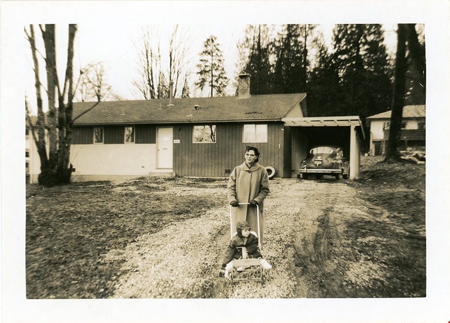
Lucy and Sjouke Hiemstra in front of house
https://search.heritageburnaby.ca/link/museumdescription19127
- Repository
- Burnaby Village Museum
- Date
- Feb. 1960
- Collection/Fonds
- Cornelius and Lucy Hiemstra family fonds
- Description Level
- Item
- Physical Description
- 1 photograph : b&w ; 8.5 x 11.5 cm
- Scope and Content
- Photograph of Lucy Hiemstra pushing her eldest child Sjouke Hiemstra in a stroller on the grass in front of their house located at 5636 Canada Way.
- Repository
- Burnaby Village Museum
- Collection/Fonds
- Cornelius and Lucy Hiemstra family fonds
- Description Level
- Item
- Physical Description
- 1 photograph : b&w ; 8.5 x 11.5 cm
- Scope and Content
- Photograph of Lucy Hiemstra pushing her eldest child Sjouke Hiemstra in a stroller on the grass in front of their house located at 5636 Canada Way.
- Geographic Access
- Canada Way
- Accession Code
- BV022.15.7
- Access Restriction
- No restrictions
- Reproduction Restriction
- May be restricted by third party rights
- Date
- Feb. 1960
- Media Type
- Photograph
- Historic Neighbourhood
- Burnaby Lake (Historic Neighbourhood)
- Planning Study Area
- Burnaby Lake Area
- Notes
- Title based on contents of photograph
- note in blue ink on verso of photograph reads: "Feb. 1960 / Sg. C. Hiemstra Jr."
- Stamp on verso of photograph reads: "919A"
Images

Madelaine Anderson
https://search.heritageburnaby.ca/link/archivedescription37452
- Repository
- City of Burnaby Archives
- Date
- 1963 (date of original), copied 1991
- Collection/Fonds
- Burnaby Historical Society fonds
- Description Level
- Item
- Physical Description
- 1 photograph : b&w ; 3.2 x 3.2 cm print on contact sheet 20.2 x 25.4 cm
- Scope and Content
- Photograph of Madelaine Anderson at the back of her home at 3908 Norland Avenue (previously numbered 4437 Norland Avenue), facing northwest. The Sprott overpass over the Trans Canada Highway can be seen under construction in the background.
- Repository
- City of Burnaby Archives
- Date
- 1963 (date of original), copied 1991
- Collection/Fonds
- Burnaby Historical Society fonds
- Subseries
- Burnaby Image Bank subseries
- Physical Description
- 1 photograph : b&w ; 3.2 x 3.2 cm print on contact sheet 20.2 x 25.4 cm
- Description Level
- Item
- Record No.
- 370-040
- Access Restriction
- No restrictions
- Reproduction Restriction
- No restrictions
- Accession Number
- BHS1999-03
- Scope and Content
- Photograph of Madelaine Anderson at the back of her home at 3908 Norland Avenue (previously numbered 4437 Norland Avenue), facing northwest. The Sprott overpass over the Trans Canada Highway can be seen under construction in the background.
- Media Type
- Photograph
- Notes
- Title based on contents of photograph
- 1 b&w copy negative accompanying
- Photo is missing pieces at centre and bottom left
- Geographic Access
- Norland Avenue
- Street Address
- 3908 Norland Avenue
- Historic Neighbourhood
- Burnaby Lake (Historic Neighbourhood)
- Planning Study Area
- Douglas-Gilpin Area
Images


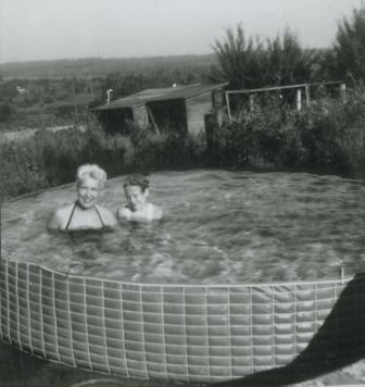
Madelaine and Janet Anderson in their pool
https://search.heritageburnaby.ca/link/archivedescription37445
- Repository
- City of Burnaby Archives
- Date
- 1961 (date of original), copied 1991
- Collection/Fonds
- Burnaby Historical Society fonds
- Description Level
- Item
- Physical Description
- 1 photograph : b&w ; 4.0 x 3.7 cm print on contact sheet 20.2 x 25.4 cm
- Scope and Content
- Photograph of mother and daughter Madelaine and Janet Anderson in the swimming pool behind their home at 3908 Norland Avenue (previously numbered 4437 Norland Avenue).
- Repository
- City of Burnaby Archives
- Date
- 1961 (date of original), copied 1991
- Collection/Fonds
- Burnaby Historical Society fonds
- Subseries
- Burnaby Image Bank subseries
- Physical Description
- 1 photograph : b&w ; 4.0 x 3.7 cm print on contact sheet 20.2 x 25.4 cm
- Description Level
- Item
- Record No.
- 370-033
- Access Restriction
- No restrictions
- Reproduction Restriction
- No restrictions
- Accession Number
- BHS1999-03
- Scope and Content
- Photograph of mother and daughter Madelaine and Janet Anderson in the swimming pool behind their home at 3908 Norland Avenue (previously numbered 4437 Norland Avenue).
- Media Type
- Photograph
- Notes
- Title based on contents of photograph
- 1 b&w copy negative accompanying
- Geographic Access
- Norland Avenue
- Street Address
- 3908 Norland Avenue
- Historic Neighbourhood
- Burnaby Lake (Historic Neighbourhood)
- Planning Study Area
- Douglas-Gilpin Area
Images
![The Maid of the Mist, [1902] thumbnail](/media/hpo/_Data/_Archives_Images/_Unrestricted/477/477-101.jpg?width=280)
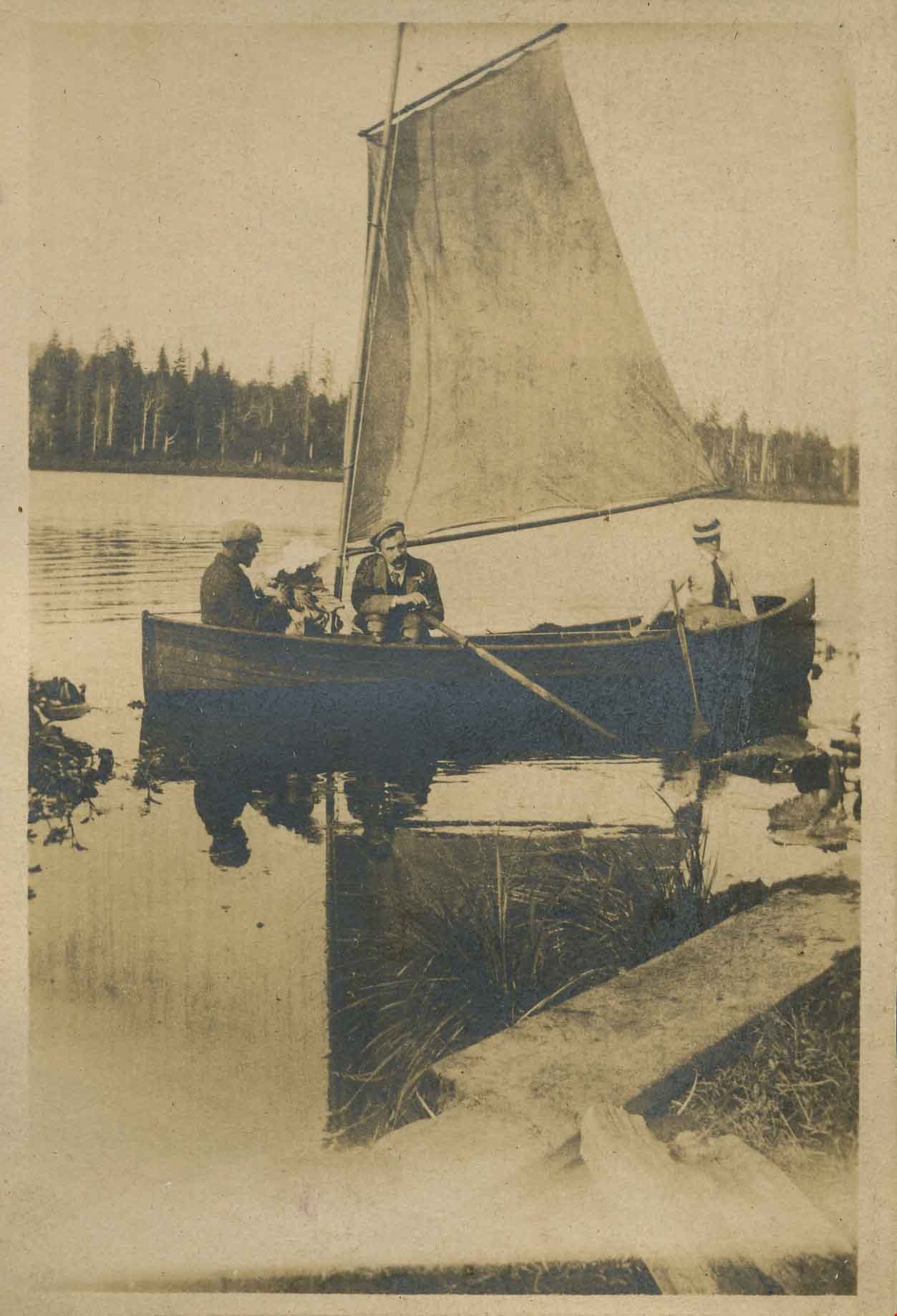
The Maid of the Mist
https://search.heritageburnaby.ca/link/archivedescription38782
- Repository
- City of Burnaby Archives
- Date
- [1902]
- Collection/Fonds
- Peers Family and Hill Family fonds
- Description Level
- Item
- Physical Description
- 1 photograph : b&w ; 6.5 x 10.5 cm on page 11.5 x 14 cm (pasted in album)
- Scope and Content
- Photograph of a group rowing a boat on a lake (most likely Deer Lake). The child with her hand in the water is Kitty Hill and the woman seated next to her (facing the camera) is Annie Hill, her mother. Her father, Claude Hill is pictured rowing (directly behind Kitty, wearing a white hat) and the…
- Repository
- City of Burnaby Archives
- Date
- [1902]
- Collection/Fonds
- Peers Family and Hill Family fonds
- Physical Description
- 1 photograph : b&w ; 6.5 x 10.5 cm on page 11.5 x 14 cm (pasted in album)
- Description Level
- Item
- Record No.
- 477-101
- Access Restriction
- No restrictions
- Reproduction Restriction
- No known restrictions
- Accession Number
- 2007-12
- Scope and Content
- Photograph of a group rowing a boat on a lake (most likely Deer Lake). The child with her hand in the water is Kitty Hill and the woman seated next to her (facing the camera) is Annie Hill, her mother. Her father, Claude Hill is pictured rowing (directly behind Kitty, wearing a white hat) and the man seated at the head of the boat (also wearing a white hat) is most likely Claude's brother, Bernard Hill. The other two people are unidentified.
- Names
- Hill, Annie Sara Kenrick
- Hill, Bernard R.
- Hill, Louis Claude "Claude"
- Peers, Katherine Maude Hill "Kitty"
- Media Type
- Photograph
- Notes
- Title based on caption written below photograph in album
- Geographic Access
- Deer Lake
- Historic Neighbourhood
- Burnaby Lake (Historic Neighbourhood)
Images
![The Maid of the Mist, [1902] thumbnail](/media/hpo/_Data/_Archives_Images/_Unrestricted/477/477-101.jpg)

The Maid of the Mist
https://search.heritageburnaby.ca/link/archivedescription38817
- Repository
- City of Burnaby Archives
- Date
- 1902
- Collection/Fonds
- Peers Family and Hill Family fonds
- Description Level
- Item
- Physical Description
- 1 photograph : sepia ; 5.5 x 8 cm on page 11.5 x 14 cm (pasted in album)
- Scope and Content
- Photograph of the "Maid of the Mist," the Hill family boat - most likely at Deer Lake. Seated on the far left (facing away from camera) is Claude Hill. His daughter Kitty is seated in front of him while an unidentified man is in the middle (facing camera) The woman is also unidentified.
- Repository
- City of Burnaby Archives
- Date
- 1902
- Collection/Fonds
- Peers Family and Hill Family fonds
- Physical Description
- 1 photograph : sepia ; 5.5 x 8 cm on page 11.5 x 14 cm (pasted in album)
- Description Level
- Item
- Record No.
- 477-136
- Access Restriction
- No restrictions
- Reproduction Restriction
- No known restrictions
- Accession Number
- 2007-12
- Scope and Content
- Photograph of the "Maid of the Mist," the Hill family boat - most likely at Deer Lake. Seated on the far left (facing away from camera) is Claude Hill. His daughter Kitty is seated in front of him while an unidentified man is in the middle (facing camera) The woman is also unidentified.
- Media Type
- Photograph
- Notes
- Title based on caption accompanying photograph
- Geographic Access
- Deer Lake
- Historic Neighbourhood
- Burnaby Lake (Historic Neighbourhood)
Images
![Man riding a horse, [1904] thumbnail](/media/hpo/_Data/_Archives_Images/_Unrestricted/477/477-154.jpg?width=280)
Man riding a horse
https://search.heritageburnaby.ca/link/archivedescription38835
- Repository
- City of Burnaby Archives
- Date
- [1904]
- Collection/Fonds
- Peers Family and Hill Family fonds
- Description Level
- Item
- Physical Description
- 1 photograph : b&w ; 5 x 7 cm on page 11.5 x 14 cm (pasted in album)
- Scope and Content
- Photograph of an unidentified man riding a horse - most likely taken at the home of Claude Hill in the Burnaby Lake area. The man may be E.B. Wetenhall, friend of the Hill family.
- Repository
- City of Burnaby Archives
- Date
- [1904]
- Collection/Fonds
- Peers Family and Hill Family fonds
- Physical Description
- 1 photograph : b&w ; 5 x 7 cm on page 11.5 x 14 cm (pasted in album)
- Description Level
- Item
- Record No.
- 477-154
- Access Restriction
- No restrictions
- Reproduction Restriction
- No known restrictions
- Accession Number
- 2007-12
- Scope and Content
- Photograph of an unidentified man riding a horse - most likely taken at the home of Claude Hill in the Burnaby Lake area. The man may be E.B. Wetenhall, friend of the Hill family.
- Subjects
- Animals - Horses
- Names
- Wetenhall, E.B.
- Media Type
- Photograph
- Notes
- Title based on contents of photograph
- Geographic Access
- Deer Lake Avenue
- Historic Neighbourhood
- Burnaby Lake (Historic Neighbourhood)
- Planning Study Area
- Morley-Buckingham Area
Images
![Man riding a horse, [1904] thumbnail](/media/hpo/_Data/_Archives_Images/_Unrestricted/477/477-154.jpg)