Narrow Results By
Subject
- Advertising Medium - Signs and Signboards 1
- Agriculture - Farms 5
- Agriculture - Fruit and Berries 1
- Animals - Cats 1
- Animals - Dogs 5
- Animals - Fowl 1
- Animals - Goats 1
- Animals - Horses 1
- Buildings - Civic - Museums 1
- Buildings - Commercial - Restaurants 1
- Buildings - Heritage 6
- Buildings - Industrial - Mills 1
Creator
- Alphonse J. Toebaert 1
- Bowman and Cullerne 1
- British Columbia Underwriters' Association 1
- Burnaby Village Museum 2
- Damer, Eric 1
- E. Evans and Son 1
- Enoch Evans 1
- Fong, Denise 1
- Lloyd, Frank Ernest 10
- Lloyd's Studio 5
- McCarter & Nairne 1
- Plan Department, British Columbia Insurance Underwriters' Association 1
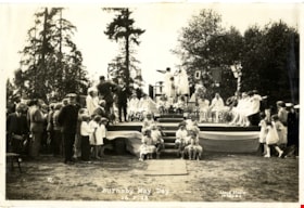
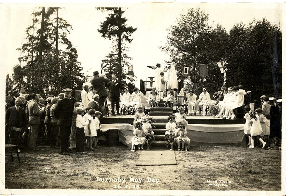
Burnaby May Day ceremony
https://search.heritageburnaby.ca/link/museumdescription4883
- Repository
- Burnaby Village Museum
- Date
- May 26, 1928
- Collection/Fonds
- Burnaby Girl Guides fonds
- Description Level
- Item
- Physical Description
- 1 photograph : sepia ;11.5 x 17 cm
- Scope and Content
- Photograph of the crowning of May Queen Sylvia Murley (later Sylvia Auvache) at Robert Burnaby Park. The May Queen and her suite are seated on chairs on a stage, with flower girls seated on the steps leading up to the stage. Men, women and children are gathered around the stage to watch the crownin…
- Repository
- Burnaby Village Museum
- Collection/Fonds
- Burnaby Girl Guides fonds
- Description Level
- Item
- Physical Description
- 1 photograph : sepia ;11.5 x 17 cm
- Scope and Content
- Photograph of the crowning of May Queen Sylvia Murley (later Sylvia Auvache) at Robert Burnaby Park. The May Queen and her suite are seated on chairs on a stage, with flower girls seated on the steps leading up to the stage. Men, women and children are gathered around the stage to watch the crowning of the May Queen.
- Subjects
- Events - May Day
- Geographic Access
- Robert Burnaby Park
- Accession Code
- BV015.35.241
- Access Restriction
- No restrictions
- Reproduction Restriction
- No known restrictions
- Date
- May 26, 1928
- Media Type
- Photograph
- Historic Neighbourhood
- Burnaby Lake (Historic Neighbourhood)
- Planning Study Area
- Lakeview-Mayfield Area
- Related Material
- See also photograph HV972.204.4
- Scan Resolution
- 600
- Scan Date
- January 4, 2021
- Scale
- 100
- Notes
- Title based on content of photograph
- Type script in white on bottom of photograph reads: "Burnaby May Day / 26. 5.28 / Lloyd Studio / McKay B.C."
- Stamp in black ink on verso of photograph reads: "Lloyd's Studio / 3966 Kingsway / McKay, B.C. Calr. 343R2"
- Photograph is a part of scrapbook (page 26) "Burnaby Girl Guides. -- [1914]-1969, predominant ca. 1920" (BV.015.35.164)
Images

Burnaby Park
https://search.heritageburnaby.ca/link/archivedescription34577
- Repository
- City of Burnaby Archives
- Date
- 1927
- Collection/Fonds
- Burnaby Historical Society fonds
- Description Level
- Item
- Physical Description
- 1 photograph : b&w ; 34.5 x 23.3 cm mounted on 49.5 x 35.1 cm cardboard
- Scope and Content
- Photograph taken from Burnaby Park, including trees and mountains in the distance.
- Repository
- City of Burnaby Archives
- Date
- 1927
- Collection/Fonds
- Burnaby Historical Society fonds
- Subseries
- Photographs subseries
- Physical Description
- 1 photograph : b&w ; 34.5 x 23.3 cm mounted on 49.5 x 35.1 cm cardboard
- Description Level
- Item
- Record No.
- 055-002
- Access Restriction
- No restrictions
- Reproduction Restriction
- No known restrictions
- Accession Number
- BHS2007-04
- Scope and Content
- Photograph taken from Burnaby Park, including trees and mountains in the distance.
- Media Type
- Photograph
- Photographer
- Lloyd's Studio
- Notes
- Title based on contents of photograph
- Annotation on bottom front of cardboard reads, "Burnaby Park / Officially Opened August 6th, 1927"
- Geographic Access
- Robert Burnaby Park
- Wedgewood Street
- Street Address
- 8155 Wedgewood Street
- Historic Neighbourhood
- Burnaby Lake (Historic Neighbourhood)
- Planning Study Area
- Lakeview-Mayfield Area
Images

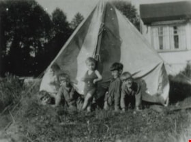
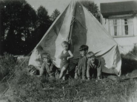
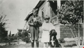
Children in a tent
https://search.heritageburnaby.ca/link/archivedescription37996
- Repository
- City of Burnaby Archives
- Date
- 1927 (date of original), copied 1991
- Collection/Fonds
- Burnaby Historical Society fonds
- Description Level
- Item
- Physical Description
- 1 photograph : b&w ; 3.0 x 4.0 cm print on contact sheet 20.5 x 26.4 cm
- Scope and Content
- Photograph of five children outside a tent in the yard of Hart House. Likely, left to right: John, Dinty, Anna, Sonny (Monty), and Harold Moore.
- Repository
- City of Burnaby Archives
- Date
- 1927 (date of original), copied 1991
- Collection/Fonds
- Burnaby Historical Society fonds
- Subseries
- Burnaby Image Bank subseries
- Physical Description
- 1 photograph : b&w ; 3.0 x 4.0 cm print on contact sheet 20.5 x 26.4 cm
- Description Level
- Item
- Record No.
- 370-583
- Access Restriction
- No restrictions
- Reproduction Restriction
- No known restrictions
- Accession Number
- BHS1999-03
- Scope and Content
- Photograph of five children outside a tent in the yard of Hart House. Likely, left to right: John, Dinty, Anna, Sonny (Monty), and Harold Moore.
- Subjects
- Structures - Tents
- Names
- Whittaker, Anna Marie Moore
- Moore, Montague Hutchings "Monty"
- Moore, Harold Frederick
- Moore, John Gifford
- Moore, William A. "Dinty"
- Media Type
- Photograph
- Notes
- Title based on contents of photograph
- 1 b&w copy negative accompanying
- Geographic Access
- Deer Lake Avenue
- Street Address
- 6664 Deer Lake Avenue
- Historic Neighbourhood
- Burnaby Lake (Historic Neighbourhood)
- Planning Study Area
- Morley-Buckingham Area
Images

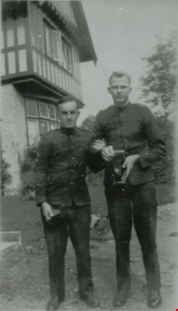
Chip and Roy at Hart House
https://search.heritageburnaby.ca/link/archivedescription38004
- Repository
- City of Burnaby Archives
- Date
- 1929 (date of original), copied 1991
- Collection/Fonds
- Burnaby Historical Society fonds
- Description Level
- Item
- Physical Description
- 1 photograph : b&w ; 4.6 x 2.6 cm print on contact sheet 20.5 x 26.4 cm
- Scope and Content
- Photograph of Chip and Roy, two Australian soldiers or sailors, at Hart House. They are in uniform, and one of them is holding a camera.
- Repository
- City of Burnaby Archives
- Date
- 1929 (date of original), copied 1991
- Collection/Fonds
- Burnaby Historical Society fonds
- Subseries
- Burnaby Image Bank subseries
- Physical Description
- 1 photograph : b&w ; 4.6 x 2.6 cm print on contact sheet 20.5 x 26.4 cm
- Description Level
- Item
- Record No.
- 370-591
- Access Restriction
- No restrictions
- Reproduction Restriction
- No known restrictions
- Accession Number
- BHS1999-03
- Scope and Content
- Photograph of Chip and Roy, two Australian soldiers or sailors, at Hart House. They are in uniform, and one of them is holding a camera.
- Subjects
- Photographic Tools and Equipment - Cameras
- Occupations - Military Personnel
- Clothing - Military Uniforms
- Media Type
- Photograph
- Notes
- Title based on contents of photograph
- 1 b&w copy negative accompanying
- Geographic Access
- Deer Lake Avenue
- Street Address
- 6664 Deer Lake Avenue
- Historic Neighbourhood
- Burnaby Lake (Historic Neighbourhood)
- Planning Study Area
- Morley-Buckingham Area
Images
Claude and Annie Hill's house
https://search.heritageburnaby.ca/link/archivedescription39222
- Repository
- City of Burnaby Archives
- Date
- 1923
- Collection/Fonds
- Peers Family and Hill Family fonds
- Description Level
- Item
- Physical Description
- 1 photograph : sepia ; 6.7 x 10.3 cm on page 24.5 x 32.5 cm (pasted in album)
- Scope and Content
- Photograph of Claude and Annie Hill's house. This was the third home the Hill's lived in that was in the Burnaby Lake area, the first two being known as Brookfield and Broadview.
- Repository
- City of Burnaby Archives
- Date
- 1923
- Collection/Fonds
- Peers Family and Hill Family fonds
- Physical Description
- 1 photograph : sepia ; 6.7 x 10.3 cm on page 24.5 x 32.5 cm (pasted in album)
- Description Level
- Item
- Record No.
- 477-541
- Access Restriction
- No restrictions
- Reproduction Restriction
- No known restrictions
- Accession Number
- 2007-12
- Scope and Content
- Photograph of Claude and Annie Hill's house. This was the third home the Hill's lived in that was in the Burnaby Lake area, the first two being known as Brookfield and Broadview.
- Subjects
- Buildings - Residential - Houses
- Media Type
- Photograph
- Notes
- Title based on caption accompanying photograph
- Geographic Access
- Deer Lake Avenue
- Street Address
- 6570 Deer Lake Avenue
- Historic Neighbourhood
- Burnaby Lake (Historic Neighbourhood)
- Planning Study Area
- Douglas-Gilpin Area
Images
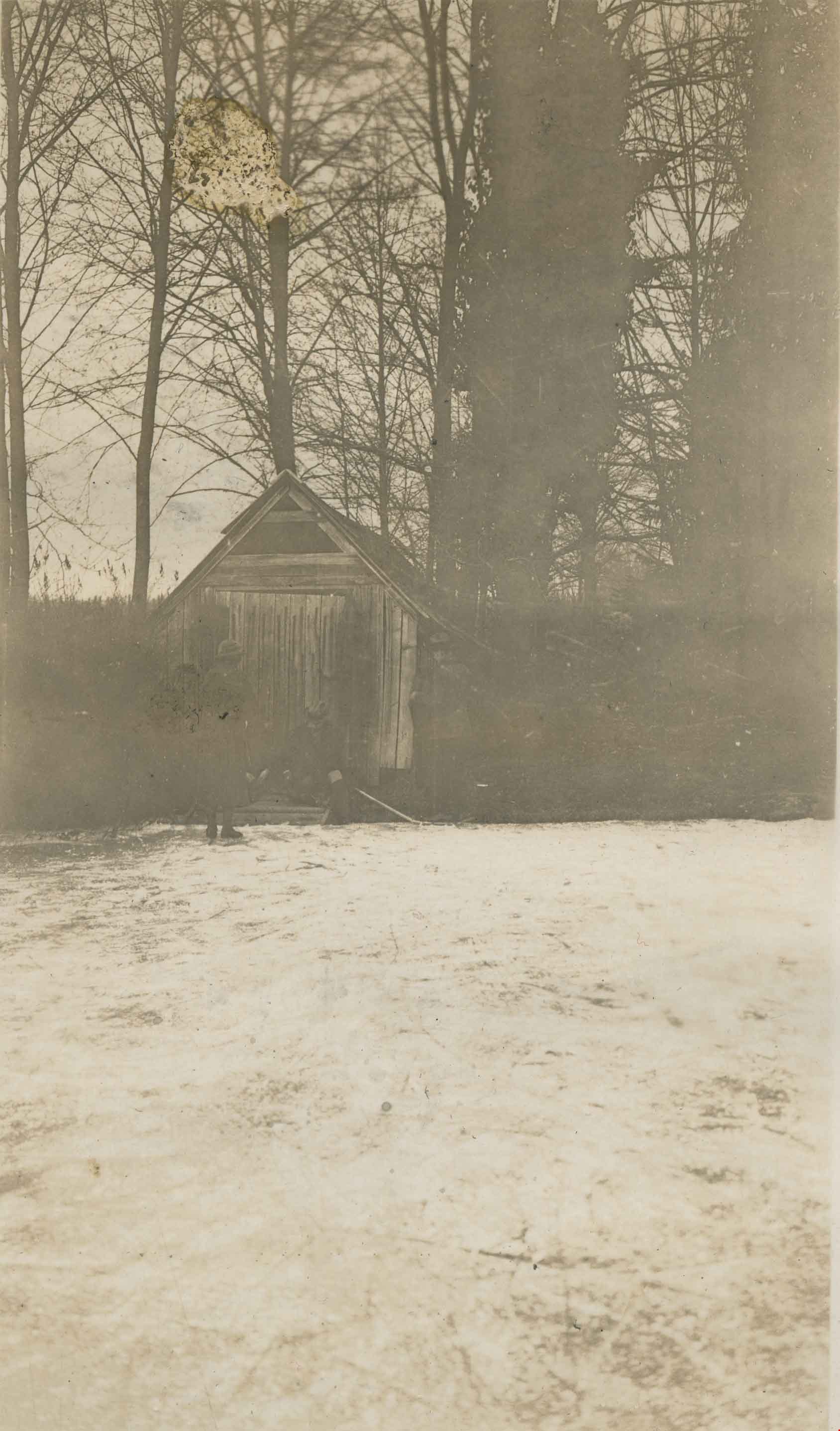
Claude Hill's Boathouse
https://search.heritageburnaby.ca/link/archivedescription34310
- Repository
- City of Burnaby Archives
- Date
- 1924
- Collection/Fonds
- Burnaby Historical Society fonds
- Description Level
- Item
- Physical Description
- 1 photograph : b&w ; 8 x 13.3 cm on page 17.5 x 24.5 cm
- Scope and Content
- Photograph of three people outside Claude Hill's boathouse - all unidentified. The boathouse was located at the mouth of Deer Lake Creek (historically known as Deer Lake Brook) This photograph was taken during the winter of 1924 and the water is frozen over with ice.
- Repository
- City of Burnaby Archives
- Date
- 1924
- Collection/Fonds
- Burnaby Historical Society fonds
- Subseries
- Peers family subseries
- Physical Description
- 1 photograph : b&w ; 8 x 13.3 cm on page 17.5 x 24.5 cm
- Description Level
- Item
- Record No.
- 020-017
- Access Restriction
- No restrictions
- Reproduction Restriction
- No known restrictions
- Accession Number
- BHS2007-04
- Scope and Content
- Photograph of three people outside Claude Hill's boathouse - all unidentified. The boathouse was located at the mouth of Deer Lake Creek (historically known as Deer Lake Brook) This photograph was taken during the winter of 1924 and the water is frozen over with ice.
- Media Type
- Photograph
- Notes
- Title based on caption accompanying photograph
- Geographic Access
- Deer Lake Brook
- Historic Neighbourhood
- Burnaby Lake (Historic Neighbourhood)
- Planning Study Area
- Morley-Buckingham Area
Images
![Climbing onto a diving platform, [between 1925 and 1939] thumbnail](/media/hpo/_Data/_BVM_Images/2000/200400220005.jpg?width=280)
Climbing onto a diving platform
https://search.heritageburnaby.ca/link/museumdescription1753
- Repository
- Burnaby Village Museum
- Date
- [between 1925 and 1939]
- Collection/Fonds
- Burnaby Village Museum Photograph collection
- Description Level
- Item
- Physical Description
- 1 photograph : sepia ; 13 x 8 cm
- Scope and Content
- Photograph of an unidentified woman in a tank-style swimsuit climbing onto a wooden diving platform in Deer Lake.
- Repository
- Burnaby Village Museum
- Collection/Fonds
- Burnaby Village Museum Photograph collection
- Description Level
- Item
- Physical Description
- 1 photograph : sepia ; 13 x 8 cm
- Scope and Content
- Photograph of an unidentified woman in a tank-style swimsuit climbing onto a wooden diving platform in Deer Lake.
- Geographic Access
- Deer Lake
- Accession Code
- BV004.22.5
- Access Restriction
- No restrictions
- Reproduction Restriction
- No known restrictions
- Date
- [between 1925 and 1939]
- Media Type
- Photograph
- Historic Neighbourhood
- Burnaby Lake (Historic Neighbourhood)
- Planning Study Area
- Morley-Buckingham Area
- Scan Resolution
- 600
- Scan Date
- 09-Jun-09
- Scale
- 100
- Notes
- Title based on contents of photograph
Images
![Climbing onto a diving platform, [between 1925 and 1939] thumbnail](/media/hpo/_Data/_BVM_Images/2000/200400220005.jpg)

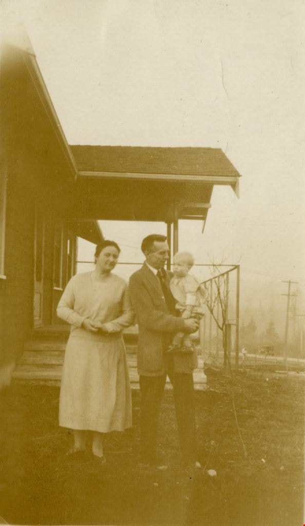
Close up of front of Roberts' house 5118 Douglas Road
https://search.heritageburnaby.ca/link/archivedescription91836
- Repository
- City of Burnaby Archives
- Date
- 1927
- Collection/Fonds
- Small family fonds
- Description Level
- Item
- Physical Description
- 1 photograph : sepia ; 10 cm x 6 cm
- Scope and Content
- Photograph of John W. and Mary Roberts (pregnant with son Roland) and their son Edward Roberts standing in front of their house at 5118 Douglas Road. The front steps and porch of the house are complete, but the pillars and sidewalk are not yet in place. In the background is the framework for nett…
- Repository
- City of Burnaby Archives
- Date
- 1927
- Collection/Fonds
- Small family fonds
- Physical Description
- 1 photograph : sepia ; 10 cm x 6 cm
- Description Level
- Item
- Record No.
- 620-017
- Access Restriction
- No restrictions
- Reproduction Restriction
- No known restrictions
- Accession Number
- 2017-01
- Scope and Content
- Photograph of John W. and Mary Roberts (pregnant with son Roland) and their son Edward Roberts standing in front of their house at 5118 Douglas Road. The front steps and porch of the house are complete, but the pillars and sidewalk are not yet in place. In the background is the framework for netting around the property's tennis court. To the right is Douglas Road, where the Roberts' mailbox and a car are visible in the distance.
- Media Type
- Photograph
- Notes
- Transcribed title
- Title transcribed from donor's notes
- Note in black ink on verso of photograph reads: "Aug, 1927 / Mother, father and Teddy / Please return"
- Note in black ink on verso of photograph reads: "How's this John?"
- Stamp on verso of photograph read: "56"
- Note in blue ink on verso of photograph reads: "P.17"
- 5118 Douglas Road renumbered to 3131 Douglas Road in 1958 and to 5538 Dominion Street in 1970 or 1971
- Street Address
- 3131 Douglas Road
- 5118 Douglas Road
- 5538 Dominion Street
- Historic Neighbourhood
- Burnaby Lake (Historic Neighbourhood)
- Planning Study Area
- Ardingley-Sprott Area
Images
![Construction of Elworth, [1922] thumbnail](/media/hpo/_Data/_BVM_Images/1976/1976_0037_0001_001.jpg?width=280)
Construction of Elworth
https://search.heritageburnaby.ca/link/museumdescription676
- Repository
- Burnaby Village Museum
- Date
- [1922]
- Collection/Fonds
- E.W. Bateman family fonds
- Description Level
- Item
- Physical Description
- 1 photograph : b&w ; 6.9 x 11.5 cm
- Scope and Content
- Phoptograph of the construction of Mr. and Mrs. Edwin W. and Mary Bateman's house "Elworth." The path in the garden to the front porch has already been established in the photograph, and the frames of the house are erected, with side panels being fitted for the first floor. At least three people …
- Repository
- Burnaby Village Museum
- Collection/Fonds
- E.W. Bateman family fonds
- Description Level
- Item
- Physical Description
- 1 photograph : b&w ; 6.9 x 11.5 cm
- Scope and Content
- Phoptograph of the construction of Mr. and Mrs. Edwin W. and Mary Bateman's house "Elworth." The path in the garden to the front porch has already been established in the photograph, and the frames of the house are erected, with side panels being fitted for the first floor. At least three people are sitting by the openings made for the windows. Stamped on the back of the photo: "216." The house is located at the site of what would become Burnaby Village Museum, 6501 Deer Lake Avenue.
- Geographic Access
- Deer Lake Avenue
- Street Address
- 6501 Deer Lake Avenue
- Accession Code
- HV976.37.1
- Access Restriction
- No restrictions
- Reproduction Restriction
- No known restrictions
- Date
- [1922]
- Media Type
- Photograph
- Historic Neighbourhood
- Burnaby Lake (Historic Neighbourhood)
- Planning Study Area
- Morley-Buckingham Area
- Scan Resolution
- 600
- Scan Date
- 2023-06-13
- Notes
- Title based on contents of photograph
Images
![Construction of Elworth, [1922] thumbnail](/media/hpo/_Data/_BVM_Images/1976/1976_0037_0001_001.jpg)

Construction of Saint Theresa's Roman Catholic Church
https://search.heritageburnaby.ca/link/museumdescription903
- Repository
- Burnaby Village Museum
- Date
- March 19, 1929
- Collection/Fonds
- Burnaby Village Museum Photograph collection
- Description Level
- Item
- Physical Description
- 1 photograph : sepia ; 6.9 x 11.5 cm
- Scope and Content
- Photograph of Douglas Road (later renamed in part Canada Way) with Laurel Street in the background on the left and the site of Saint Theresa's Roman Catholic Church as a lot with blackened stumps. The church was located at the southeast corner of Canada Way and Laurel Street. The photograph is ta…
- Repository
- Burnaby Village Museum
- Collection/Fonds
- Burnaby Village Museum Photograph collection
- Description Level
- Item
- Physical Description
- 1 photograph : sepia ; 6.9 x 11.5 cm
- Scope and Content
- Photograph of Douglas Road (later renamed in part Canada Way) with Laurel Street in the background on the left and the site of Saint Theresa's Roman Catholic Church as a lot with blackened stumps. The church was located at the southeast corner of Canada Way and Laurel Street. The photograph is taken from the same angle as HV975.105.1. There is a freight wagon loaded with lumber, pulled by two horses on Douglas Road. An annotation on the back of the photo reads, "March 19th 1929 / The first load of lumber taken for the construction of St St [sic] Therese [sic] Church on the Grandview Highway / Burnaby BC."
- Geographic Access
- Douglas Road
- Canada Way
- Laurel Street
- Accession Code
- HV975.105.2
- Access Restriction
- No restrictions
- Reproduction Restriction
- No known restrictions
- Date
- March 19, 1929
- Media Type
- Photograph
- Historic Neighbourhood
- Burnaby Lake (Historic Neighbourhood)
- Planning Study Area
- Douglas-Gilpin Area
- Scan Resolution
- 600
- Scan Date
- 2023-06-13
- Notes
- Title based on contents of photograph
- Information on the scope and content of the photograph is taken from an acquisition record from the time of the accession
Images

![Creek at Deer Lake, [1928] (date of original), copied 1991 thumbnail](/media/hpo/_Data/_Archives_Images/_Unrestricted/370/370-586.jpg?width=280)
Creek at Deer Lake
https://search.heritageburnaby.ca/link/archivedescription37999
- Repository
- City of Burnaby Archives
- Date
- [1928] (date of original), copied 1991
- Collection/Fonds
- Burnaby Historical Society fonds
- Description Level
- Item
- Physical Description
- 1 photograph : b&w ; 2.6 x 4.6 cm print on contact sheet 20.5 x 26.4 cm
- Scope and Content
- Photograph of a creek at Deer Lake.
- Repository
- City of Burnaby Archives
- Date
- [1928] (date of original), copied 1991
- Collection/Fonds
- Burnaby Historical Society fonds
- Subseries
- Burnaby Image Bank subseries
- Physical Description
- 1 photograph : b&w ; 2.6 x 4.6 cm print on contact sheet 20.5 x 26.4 cm
- Description Level
- Item
- Record No.
- 370-586
- Access Restriction
- No restrictions
- Reproduction Restriction
- No known restrictions
- Accession Number
- BHS1999-03
- Scope and Content
- Photograph of a creek at Deer Lake.
- Subjects
- Geographic Features - Creeks
- Media Type
- Photograph
- Notes
- Title based on contents of photograph
- 1 b&w copy negative accompanying
- Geographic Access
- Deer Lake
- Historic Neighbourhood
- Burnaby Lake (Historic Neighbourhood)
Images
![Creek at Deer Lake, [1928] (date of original), copied 1991 thumbnail](/media/hpo/_Data/_Archives_Images/_Unrestricted/370/370-586.jpg)
Dawkins Children
https://search.heritageburnaby.ca/link/archivedescription35201
- Repository
- City of Burnaby Archives
- Date
- 1923 (date of original), copied 1986
- Collection/Fonds
- Burnaby Historical Society fonds
- Description Level
- Item
- Physical Description
- 1 photograph : b&w ; 12.7 x 17.8 cm print
- Scope and Content
- Photograph of Albert Dawkins, 9 years old, and Elsie Dawkins, 5. Taken in front of the Dawkins family home on Balfour Avenue.
- Repository
- City of Burnaby Archives
- Date
- 1923 (date of original), copied 1986
- Collection/Fonds
- Burnaby Historical Society fonds
- Subseries
- Pioneer Tales subseries
- Physical Description
- 1 photograph : b&w ; 12.7 x 17.8 cm print
- Description Level
- Item
- Record No.
- 204-058
- Access Restriction
- No restrictions
- Reproduction Restriction
- No known restrictions
- Accession Number
- BHS1988-03
- Scope and Content
- Photograph of Albert Dawkins, 9 years old, and Elsie Dawkins, 5. Taken in front of the Dawkins family home on Balfour Avenue.
- Media Type
- Photograph
- Notes
- Title based on contents of photograph
- Geographic Access
- Atlee Avenue
- Historic Neighbourhood
- Burnaby Lake (Historic Neighbourhood)
- Planning Study Area
- Douglas-Gilpin Area
Images

![Dawkins family, [192-] (date of original), copied 1986 thumbnail](/media/hpo/_Data/_Archives_Images/_Unrestricted/204/204-059.jpg?width=280)
Dawkins family
https://search.heritageburnaby.ca/link/archivedescription35202
- Repository
- City of Burnaby Archives
- Date
- [192-] (date of original), copied 1986
- Collection/Fonds
- Burnaby Historical Society fonds
- Description Level
- Item
- Physical Description
- 1 photograph : b&w ; 12.7 x 17.8 cm print
- Scope and Content
- Photograph of Elsie and Albert Dawkins with their father, John Dawkins, in front of the wood shed at the family home on Balfour Avenue.
- Repository
- City of Burnaby Archives
- Date
- [192-] (date of original), copied 1986
- Collection/Fonds
- Burnaby Historical Society fonds
- Subseries
- Pioneer Tales subseries
- Physical Description
- 1 photograph : b&w ; 12.7 x 17.8 cm print
- Description Level
- Item
- Record No.
- 204-059
- Access Restriction
- No restrictions
- Reproduction Restriction
- No known restrictions
- Accession Number
- BHS1988-03
- Scope and Content
- Photograph of Elsie and Albert Dawkins with their father, John Dawkins, in front of the wood shed at the family home on Balfour Avenue.
- Media Type
- Photograph
- Notes
- Title based on contents of photograph
- Geographic Access
- Atlee Avenue
- Historic Neighbourhood
- Burnaby Lake (Historic Neighbourhood)
- Planning Study Area
- Douglas-Gilpin Area
Images
![Dawkins family, [192-] (date of original), copied 1986 thumbnail](/media/hpo/_Data/_Archives_Images/_Unrestricted/204/204-059.jpg)
![Dawkins family, [1925] (date of original), copied 1991 thumbnail](/media/hpo/_Data/_Archives_Images/_Unrestricted/370/370-279.jpg?width=280)
Dawkins family
https://search.heritageburnaby.ca/link/archivedescription37691
- Repository
- City of Burnaby Archives
- Date
- [1925] (date of original), copied 1991
- Collection/Fonds
- Burnaby Historical Society fonds
- Description Level
- Item
- Physical Description
- 1 photograph : b&w ; 4.3 x 2.6 cm print on contact sheet 20.2 x 25.3 cm
- Scope and Content
- Photograph of the Dawkins father and children standing outside the woodshed at their home on Balfour Avenue (later renamed Atlee Avenue). Left to right: Elsie Dawkins, John Dawkins, and Albert Dawkins.
- Repository
- City of Burnaby Archives
- Date
- [1925] (date of original), copied 1991
- Collection/Fonds
- Burnaby Historical Society fonds
- Subseries
- Burnaby Image Bank subseries
- Physical Description
- 1 photograph : b&w ; 4.3 x 2.6 cm print on contact sheet 20.2 x 25.3 cm
- Description Level
- Item
- Record No.
- 370-279
- Access Restriction
- No restrictions
- Reproduction Restriction
- No known restrictions
- Accession Number
- BHS1999-03
- Scope and Content
- Photograph of the Dawkins father and children standing outside the woodshed at their home on Balfour Avenue (later renamed Atlee Avenue). Left to right: Elsie Dawkins, John Dawkins, and Albert Dawkins.
- Media Type
- Photograph
- Notes
- Title based on contents of photograph
- 1 b&w copy negative accompanying
- Geographic Access
- Atlee Avenue
- Historic Neighbourhood
- Burnaby Lake (Historic Neighbourhood)
- Planning Study Area
- Douglas-Gilpin Area
Images
![Dawkins family, [1925] (date of original), copied 1991 thumbnail](/media/hpo/_Data/_Archives_Images/_Unrestricted/370/370-279.jpg)

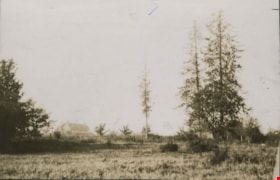
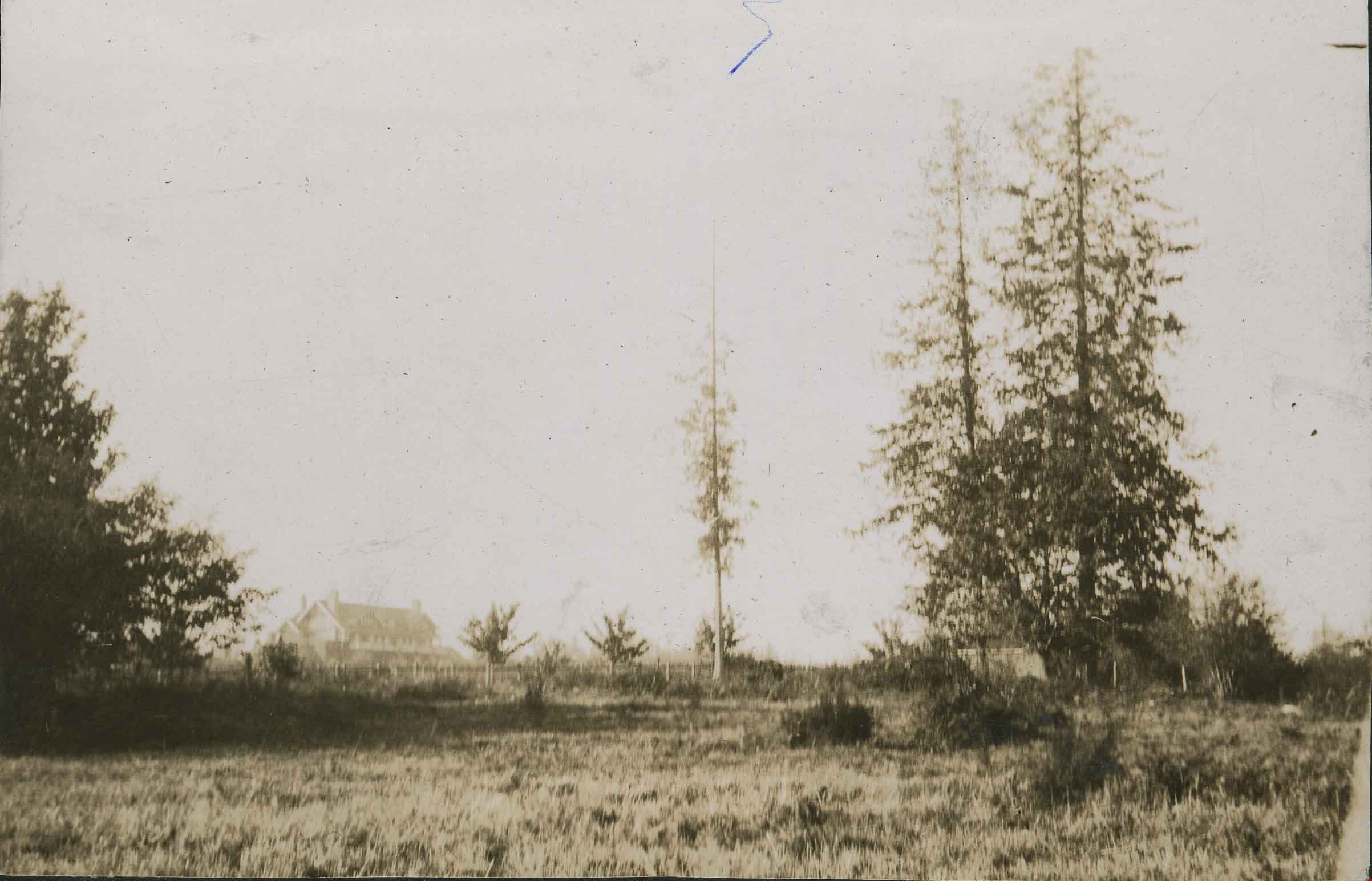
Deer Lake
https://search.heritageburnaby.ca/link/archivedescription34296
- Repository
- City of Burnaby Archives
- Date
- 1923
- Collection/Fonds
- Burnaby Historical Society fonds
- Description Level
- Item
- Physical Description
- 1 photograph : sepia ; 8 x 13.2 cm on page 17.5 x 24.8 cm
- Scope and Content
- Photograph looking over Deer Lake and snow-covered ground towards the Frederick and Alice Hart mansion known as the Avalon Estate. In the foreground the Hart's cottage is visible; it was built near Deer Lake in 1904 as a summer retreat for the Hart family. Eventually, the family decided to reside a…
- Repository
- City of Burnaby Archives
- Date
- 1923
- Collection/Fonds
- Burnaby Historical Society fonds
- Subseries
- Peers family subseries
- Physical Description
- 1 photograph : sepia ; 8 x 13.2 cm on page 17.5 x 24.8 cm
- Description Level
- Item
- Record No.
- 020-003
- Access Restriction
- No restrictions
- Reproduction Restriction
- No known restrictions
- Accession Number
- BHS2007-04
- Scope and Content
- Photograph looking over Deer Lake and snow-covered ground towards the Frederick and Alice Hart mansion known as the Avalon Estate. In the foreground the Hart's cottage is visible; it was built near Deer Lake in 1904 as a summer retreat for the Hart family. Eventually, the family decided to reside at Deer Lake year-round and began building the large estate which is visible in the centre of the photograph. In 1917, Mr. and Mrs. Hart were devastated when their son, Kingsley was killed in World War I and so they sold Avalon to Montague and Ethel Moore. The Moore's continued with improvements to the estate and renamed it Rosedale Gardens. Just to the right of the estate can be seen a home at 5140 Sperling Avenue which later became the Gayton house. To the right of that, what was originally the cottage belonging to Harriet and Maude Woodward is visible. At the time of this photograph, the cottage was being used as the Burnaby Lake United Church.
- Subjects
- Buildings - Heritage
- Buildings - Residential - Houses
- Geographic Features - Lakes and Ponds
- Media Type
- Photograph
- Notes
- Title based on caption accompanying photograph
- Geographic Access
- Deer Lake Avenue
- Deer Lake
- Sperling Avenue
- Street Address
- 6664 Deer Lake Avenue
- 5141 Sperling Avenue
- 5140 Sperling Avenue
- Historic Neighbourhood
- Burnaby Lake (Historic Neighbourhood)
- Planning Study Area
- Morley-Buckingham Area
Images


Deer Lake
https://search.heritageburnaby.ca/link/archivedescription34297
- Repository
- City of Burnaby Archives
- Date
- 1923
- Collection/Fonds
- Burnaby Historical Society fonds
- Description Level
- Item
- Physical Description
- 1 photograph : sepia
- Scope and Content
- Photograph looking over Deer Lake and snow-covered ground towards buildings and houses. To the left is the cottage and house belonging to the Woodward sisters, Harriet and Maude. The cottage, and later the house, were also used as the Burnaby Lake Post Office and a school run by Harriet Woodward. …
- Repository
- City of Burnaby Archives
- Date
- 1923
- Collection/Fonds
- Burnaby Historical Society fonds
- Subseries
- Peers family subseries
- Physical Description
- 1 photograph : sepia
- Description Level
- Item
- Record No.
- 020-004
- Access Restriction
- No restrictions
- Reproduction Restriction
- No known restrictions
- Accession Number
- BHS2007-04
- Scope and Content
- Photograph looking over Deer Lake and snow-covered ground towards buildings and houses. To the left is the cottage and house belonging to the Woodward sisters, Harriet and Maude. The cottage, and later the house, were also used as the Burnaby Lake Post Office and a school run by Harriet Woodward. At the time of this photograph, it was in use as the Burnaby Lake United Church. In the middle of the picture, numerous boathouses and a diving tower can be seen at the shoreline of the lake. To the right of the copse of trees, on the hill, is the house and post office belonging to the Woodward sisters and right of that is the home built for William J. Walker in 1907 but owned by D.R. Boucher during the 1920s. To the far right the Pole Line Road (later, Sperling Avenue) is visible along with the home of Francis J. Peers, known as Greyfriars.
- Subjects
- Buildings - Heritage
- Buildings - Residential - Houses
- Geographic Features - Lakes and Ponds
- Buildings - Religious - Churches
- Media Type
- Photograph
- Notes
- Title based on caption accompanying photograph
- Geographic Access
- Sperling Avenue
- Deer Lake
- Rugby Street
- Historic Neighbourhood
- Burnaby Lake (Historic Neighbourhood)
- Planning Study Area
- Morley-Buckingham Area
Images

Deer Lake
https://search.heritageburnaby.ca/link/archivedescription34298
- Repository
- City of Burnaby Archives
- Date
- 1923
- Collection/Fonds
- Burnaby Historical Society fonds
- Description Level
- Item
- Physical Description
- 1 photograph : sepia
- Scope and Content
- Photograph of a large tree standing near the shore of Deer Lake. In the background, the estate built by Henry and Grace Ceperley, known as "Fairacres" can be seen. Also visible is the estate's water tower. The Ceperley's purchased the land to build Fairacres in 1909 and it quickly became the mos…
- Repository
- City of Burnaby Archives
- Date
- 1923
- Collection/Fonds
- Burnaby Historical Society fonds
- Subseries
- Peers family subseries
- Physical Description
- 1 photograph : sepia
- Description Level
- Item
- Record No.
- 020-005
- Access Restriction
- No restrictions
- Reproduction Restriction
- No known restrictions
- Accession Number
- BHS2007-04
- Scope and Content
- Photograph of a large tree standing near the shore of Deer Lake. In the background, the estate built by Henry and Grace Ceperley, known as "Fairacres" can be seen. Also visible is the estate's water tower. The Ceperley's purchased the land to build Fairacres in 1909 and it quickly became the most opulent residences in all of Burnaby. In 1917, Grace died and and by 1922, her husband had decided to sell the home to a former Vancouver Mayor, Frederick Buscombe. In 1939, the Benedictines purchased the property and established a priory at the estate. A large gymnasium was added which was converted into the James Cowan Theatre when the City of Burnaby acquired the land. The old mansion was renovated and became the Burnaby Art Gallery.
- Media Type
- Photograph
- Notes
- Title based on contents of photograph
- Geographic Access
- Deer Lake
- Deer Lake Avenue
- Street Address
- 6344 Deer Lake Avenue
- Historic Neighbourhood
- Burnaby Lake (Historic Neighbourhood)
- Planning Study Area
- Douglas-Gilpin Area
Images

![Deer Lake, [between 1918 and 1920] (date of original), copied 1991 thumbnail](/media/hpo/_Data/_Archives_Images/_Unrestricted/370/370-572.jpg?width=280)
Deer Lake
https://search.heritageburnaby.ca/link/archivedescription37985
- Repository
- City of Burnaby Archives
- Date
- [between 1918 and 1920] (date of original), copied 1991
- Collection/Fonds
- Burnaby Historical Society fonds
- Description Level
- Item
- Physical Description
- 1 photograph : b&w ; 2.7 x 4.7 cm print on contact sheet 20.7 x 26.2 cm
- Scope and Content
- Photograph of Deer Lake with the shoreline reflected in the water. Houses and trees are visible on the opposite side of the lake.
- Repository
- City of Burnaby Archives
- Date
- [between 1918 and 1920] (date of original), copied 1991
- Collection/Fonds
- Burnaby Historical Society fonds
- Subseries
- Burnaby Image Bank subseries
- Physical Description
- 1 photograph : b&w ; 2.7 x 4.7 cm print on contact sheet 20.7 x 26.2 cm
- Description Level
- Item
- Record No.
- 370-572
- Access Restriction
- No restrictions
- Reproduction Restriction
- No known restrictions
- Accession Number
- BHS1999-03
- Scope and Content
- Photograph of Deer Lake with the shoreline reflected in the water. Houses and trees are visible on the opposite side of the lake.
- Media Type
- Photograph
- Notes
- Title based on contents of photograph
- 1 b&w copy negative accompanying
- Geographic Access
- Deer Lake
- Historic Neighbourhood
- Burnaby Lake (Historic Neighbourhood)
- Planning Study Area
- Oakalla Area
Images
![Deer Lake, [between 1918 and 1920] (date of original), copied 1991 thumbnail](/media/hpo/_Data/_Archives_Images/_Unrestricted/370/370-572.jpg)
![Deer Lake and Oakalla, [1929] (date of original), copied 1991 thumbnail](/media/hpo/_Data/_Archives_Images/_Unrestricted/370/370-590.jpg?width=280)
Deer Lake and Oakalla
https://search.heritageburnaby.ca/link/archivedescription38003
- Repository
- City of Burnaby Archives
- Date
- [1929] (date of original), copied 1991
- Collection/Fonds
- Burnaby Historical Society fonds
- Description Level
- Item
- Physical Description
- 1 photograph : b&w ; 2.5 x 4.5 cm print on contact sheet 20.5 x 26.4 cm
- Scope and Content
- Photograph of Deer Lake with Oakalla Prison Farm visible in the background.
- Repository
- City of Burnaby Archives
- Date
- [1929] (date of original), copied 1991
- Collection/Fonds
- Burnaby Historical Society fonds
- Subseries
- Burnaby Image Bank subseries
- Physical Description
- 1 photograph : b&w ; 2.5 x 4.5 cm print on contact sheet 20.5 x 26.4 cm
- Description Level
- Item
- Record No.
- 370-590
- Access Restriction
- No restrictions
- Reproduction Restriction
- No known restrictions
- Accession Number
- BHS1999-03
- Scope and Content
- Photograph of Deer Lake with Oakalla Prison Farm visible in the background.
- Names
- Oakalla Prison Farm
- Media Type
- Photograph
- Notes
- Title based on contents of photograph
- 1 b&w copy negative accompanying
- Geographic Access
- Deer Lake
- Historic Neighbourhood
- Burnaby Lake (Historic Neighbourhood)
- Planning Study Area
- Morley-Buckingham Area
- Oakalla Area
Images
![Deer Lake and Oakalla, [1929] (date of original), copied 1991 thumbnail](/media/hpo/_Data/_Archives_Images/_Unrestricted/370/370-590.jpg)

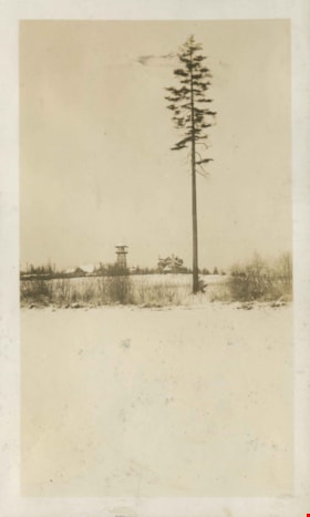
Deer Lake Gibraltar
https://search.heritageburnaby.ca/link/archivedescription34312
- Repository
- City of Burnaby Archives
- Date
- 1924
- Collection/Fonds
- Burnaby Historical Society fonds
- Description Level
- Item
- Physical Description
- 1 photograph : b&w ; 8.1 x 13.2 cm
- Scope and Content
- Photograph of the "Gibraltar" rock at mouth of Deer Lake Creek. This photograph was taken during the winter of 1924 and the lake is frozen over with ice. The surface of the lake is covered with marks made by ice skates. Deer Lake Creek is historically known as Deer Lake Brook.
- Repository
- City of Burnaby Archives
- Date
- 1924
- Collection/Fonds
- Burnaby Historical Society fonds
- Subseries
- Peers family subseries
- Physical Description
- 1 photograph : b&w ; 8.1 x 13.2 cm
- Description Level
- Item
- Record No.
- 020-019
- Access Restriction
- No restrictions
- Reproduction Restriction
- No known restrictions
- Accession Number
- BHS2007-04
- Scope and Content
- Photograph of the "Gibraltar" rock at mouth of Deer Lake Creek. This photograph was taken during the winter of 1924 and the lake is frozen over with ice. The surface of the lake is covered with marks made by ice skates. Deer Lake Creek is historically known as Deer Lake Brook.
- Subjects
- Geographic Features - Creeks
- Geographic Features - Lakes and Ponds
- Geographic Features - Rock Formations
- Media Type
- Photograph
- Notes
- Title based on caption accompanying photograph
- Geographic Access
- Deer Lake Brook
- Historic Neighbourhood
- Burnaby Lake (Historic Neighbourhood)
- Planning Study Area
- Morley-Buckingham Area
Images
