Narrow Results By
Burnaby Kingsway Branch Public Library Parking Bylaw 1975, Bylaw No. 6689
https://search.heritageburnaby.ca/link/councilreport13183
- Repository
- City of Burnaby Archives
- Report ID
- 7841
- Meeting Date
- 13-Feb-1989
- Format
- Council - Manager's Report
- Manager's Report No.
- 13
- Item No.
- 12
- Collection/Fonds
- City Council and Office of the City Clerk fonds
- Repository
- City of Burnaby Archives
- Report ID
- 7841
- Meeting Date
- 13-Feb-1989
- Format
- Council - Manager's Report
- Manager's Report No.
- 13
- Item No.
- 12
- Collection/Fonds
- City Council and Office of the City Clerk fonds
Documents
Burnaby Kingsway Branch Public Library Parking Regulation Bylaw 1975, Bylaw No. 6689
https://search.heritageburnaby.ca/link/councilreport25115
- Repository
- City of Burnaby Archives
- Report ID
- 18727
- Meeting Date
- 8-Sep-1975
- Format
- Council - Manager's Report
- Manager's Report No.
- 56
- Item No.
- 1
- Collection/Fonds
- City Council and Office of the City Clerk fonds
- Repository
- City of Burnaby Archives
- Report ID
- 18727
- Meeting Date
- 8-Sep-1975
- Format
- Council - Manager's Report
- Manager's Report No.
- 56
- Item No.
- 1
- Collection/Fonds
- City Council and Office of the City Clerk fonds
Documents
Burnaby Kingsway Branch Public Library Parking Regulation Bylaw 1975, No. 6689
https://search.heritageburnaby.ca/link/councilreport25256
- Repository
- City of Burnaby Archives
- Report ID
- 18610
- Meeting Date
- 5-Aug-1975
- Format
- Council - Manager's Report
- Manager's Report No.
- 51
- Item No.
- 5
- Collection/Fonds
- City Council and Office of the City Clerk fonds
- Repository
- City of Burnaby Archives
- Report ID
- 18610
- Meeting Date
- 5-Aug-1975
- Format
- Council - Manager's Report
- Manager's Report No.
- 51
- Item No.
- 5
- Collection/Fonds
- City Council and Office of the City Clerk fonds
Documents
Letter from the Rotary Club of Burnaby-Kingsway re: Operation Identification Program
https://search.heritageburnaby.ca/link/councilreport24553
- Repository
- City of Burnaby Archives
- Report ID
- 16963
- Meeting Date
- 22-Mar-1976
- Format
- Council - Manager's Report
- Manager's Report No.
- 18
- Item No.
- 12
- Collection/Fonds
- City Council and Office of the City Clerk fonds
- Repository
- City of Burnaby Archives
- Report ID
- 16963
- Meeting Date
- 22-Mar-1976
- Format
- Council - Manager's Report
- Manager's Report No.
- 18
- Item No.
- 12
- Collection/Fonds
- City Council and Office of the City Clerk fonds
Documents

Burnaby's Operation Identification
https://search.heritageburnaby.ca/link/archivedescription45330
- Repository
- City of Burnaby Archives
- Date
- 1976, published January 7, 1976
- Collection/Fonds
- Columbian Newspaper collection
- Description Level
- Item
- Physical Description
- 1 photograph : b&w ; 22.5 x 14.5 cm
- Scope and Content
- Photograph of municipal workers Bill Ramsay and Greg Finch putting up a sign in preparation for Burnaby's Operation Identification, which was "the largest single crime prevention policy of its kind in Canada" when "47 uniformed officers of the Burnaby detachment [joined] 47 Rotarians from the Burna…
- Repository
- City of Burnaby Archives
- Date
- 1976, published January 7, 1976
- Collection/Fonds
- Columbian Newspaper collection
- Physical Description
- 1 photograph : b&w ; 22.5 x 14.5 cm
- Description Level
- Item
- Record No.
- 480-225
- Access Restriction
- No restrictions
- Reproduction Restriction
- No restrictions
- Accession Number
- 2003-02
- Scope and Content
- Photograph of municipal workers Bill Ramsay and Greg Finch putting up a sign in preparation for Burnaby's Operation Identification, which was "the largest single crime prevention policy of its kind in Canada" when "47 uniformed officers of the Burnaby detachment [joined] 47 Rotarians from the Burnaby Kingsway Rotary Club and start door-to-door visits in 800 residences in South Burnaby. The teams [carried] electric engraving pens for marking all property susceptible to theft."
- Media Type
- Photograph
- Photographer
- King, Basil
- Notes
- Title based on contents of photograph
- Newspaper clipping attached to verso of photograph reads: "Burnaby detachment of the RCMP has embarked on the largest single crime prevention policy of its kind in Canada. "Operation Identification" officially kicks off tonight when 47 uniformed officers of the Burnaby detachment will join with 47 Rotarians from the Burnaby Kingsway Rotary Club and start door-to-door visits in 800 residences in South Burnaby. The teams will be carrying electric engraving pens for marking all property susceptible to theft. Municipal workers Bill Ramsay and Greg Finch are shown erecting one of the signs on Canada Way at 14th Avenue as "sidewalk superintendents" Sandra Finch and Corinne Williams look on."
- Geographic Access
- Canada Way
- 14th Avenue
- Historic Neighbourhood
- Edmonds (Historic Neighbourhood)
- Planning Study Area
- Edmonds Area
Images

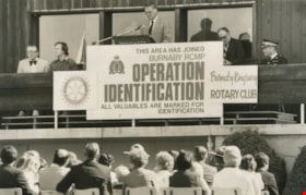
Opening of Operation Identification
https://search.heritageburnaby.ca/link/archivedescription45329
- Repository
- City of Burnaby Archives
- Date
- 1976, published May 15, 1976
- Collection/Fonds
- Columbian Newspaper collection
- Description Level
- Item
- Physical Description
- 1 photograph : b&w ; 15.5 x 24 cm
- Scope and Content
- Photograph of Attorney-General Garde Gardom addressing the crowd at the opening of Burnaby's Operation Identification which was organised by the RCMP and the Burnaby Kingsway Rotary Club.
- Repository
- City of Burnaby Archives
- Date
- 1976, published May 15, 1976
- Collection/Fonds
- Columbian Newspaper collection
- Physical Description
- 1 photograph : b&w ; 15.5 x 24 cm
- Description Level
- Item
- Record No.
- 480-224
- Access Restriction
- No restrictions
- Reproduction Restriction
- Reproduce for fair dealing purposes only
- Accession Number
- 2003-02
- Scope and Content
- Photograph of Attorney-General Garde Gardom addressing the crowd at the opening of Burnaby's Operation Identification which was organised by the RCMP and the Burnaby Kingsway Rotary Club.
- Media Type
- Photograph
- Notes
- Title based on contents of photograph
- Newspaper clipping attached to verso of photograph reads: "IDENTIFICATION Attorney-General Garde Gardom addresses spectators at the official opening of Burnaby's Operation Identification."
Images

Burnaby Arts Council subseries
https://search.heritageburnaby.ca/link/archivedescription55023
- Repository
- City of Burnaby Archives
- Date
- 1966-1989
- Collection/Fonds
- Burnaby Historical Society fonds
- Description Level
- Subseries
- Physical Description
- Textual records
- Scope and Content
- Subseries consist of minutes, correspondence, reports, membership lists, press releases, presentations, fundraising material, posters, scripts, budgets and financial statements created and compiled by the Burnaby Arts Council between 1966 and 1989.
- Repository
- City of Burnaby Archives
- Date
- 1966-1989
- Collection/Fonds
- Burnaby Historical Society fonds
- Subseries
- Burnaby Arts Council subseries
- Physical Description
- Textual records
- Description Level
- Subseries
- Accession Number
- BHS1998-06
- BHS1998-04
- Scope and Content
- Subseries consist of minutes, correspondence, reports, membership lists, press releases, presentations, fundraising material, posters, scripts, budgets and financial statements created and compiled by the Burnaby Arts Council between 1966 and 1989.
- History
- The Burnaby Arts Council was formed in the early 1960s and was comprised of representatives from six existing arts organizations: the Burnaby Writer's Society, the Burnaby Historical Society, the Burnaby Art Gallery, the Burnaby Players, the Burnaby Civic Opera and a dance group. The Council was initially called the Fine Arts Council and its first mandate was to see the Art Gallery move from its location in the basement of the Burnaby Kingsway Library into premises of its own. Sheila Kincaid was a driving force behind this venture and when the Gallery was successfully relocated, she became the first director of the Burnaby Art Gallery in its present location in Ceperley House. During the 1967 Centennial Year, one of the Municipal projects for the Centennial was the dedication of the land at Deer Lake Park for an Arts Centre. At this time, the Fine Arts Council changed its name to the Burnaby Arts Council and the group focused its energies on securing funding for needed renovations and staffing for the Gallery and Arts Centre. That year, all the groups in the Council donated their share of the Provincial Cultural Grants toward outfitting the James Cowan Theatre. 1967 also saw a big Festival of the Arts produced to raise the public's awareness of the Arts Centre. During the late 1960s, the Council worked to get registered Society status and by 1976, it was fully incorporated. Throughout the years, the Burnaby Arts Council has supported and sponsored the arts and arts programs in Burnaby. Events such as the Burnaby Craft Market, the Burnaby Summer Theatre, the Christmas Craft Fair, and various concert series, studio tours, exhibitions and displays have been presented by the Council and it continues to be an active and driving force behind the celebration of arts and culture in Burnaby.
- Media Type
- Textual Record
- Creator
- Burnaby Arts Council
- Notes
- Title based on creator and contents of subseries
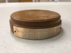
Gavel Pad
https://search.heritageburnaby.ca/link/museumartifact90815
- Repository
- Burnaby Village Museum
- Accession Code
- BV020.40.6
- Description
- Varnished and beveled wooden cylinder, used to provide a place to bang a gavel. The top surfaces is dented and scratched with use. There is a small, golden coloured metal plaque nailed into the side of the gavel pad with 2 nails. It reads "Presented to The Corporation of The District of Burnaby / Operation Identification 15-5-78 / by Burnaby Kingsway Rotary Club
- Object History
- Gavel pad used by Mayor William Copland (1987-1996). William “Bill” Copeland once joked that the reason he ran for mayor of Burnaby was because “there wasn’t a shadow of hope he would be successful” – and when the votes were tallied and he was declared victorious, Bill asked for a recount. Fortunately for the people of Burnaby, he was not serious and instead went on to become an overwhelmingly popular and much-respected leader of the community. Bill’s service to his community began early in life. Born in Vancouver on May 19, 1927, Bill was still a young man when World War Two began but that did not stop him from serving in the Merchant Marines and in the Royal Canadian Navy. After the war, Bill and his wife Ruth raised three children and in 1955 he embarked on a career with the Burnaby Fire Department. Bill went on to serve Burnaby as a firefighter until his retirement in 1987 as an Assistant Fire Chief. During this lengthy tenure, Bill held a leadership role in the Firefighters’ Union Local 323 and served as Vice President of the 6th District of the International Association of Firefighters. Over the years, Bill found various ways to contribute to the people of Burnaby. In conjunction with his work with the Fire Department, Bill was also President of the Burnaby Red Cross, Director of the Canadian National Institute for the Blind, Chairman of the St. John Ambulance, Life Member of the Burnaby North Lions Club and Member of the Deer Lake Chapter of the Rotary Club – to name but a very few of the numerous groups and organizations to which he belonged. Immediately upon his retirement from the Fire Department in 1987, Bill was asked to run for the position of Mayor of Burnaby and was successful in his bid. As Mayor, Bill earned the respect of Council and the citizens of Burnaby for his outstanding work and dedication to the community. Bill was an advocate of public participation and introduced the concept of “Area Advisory Committees” to the City with the appointment of the Hastings Street Advisory Committee. The success of this process has led to many other appointments for area advisory committees throughout Burnaby. Bill did not limit his good works to stay within the borders of the City, and as Mayor he was responsible for the two-year sister city twinning agreement with the city of El Zapotal, El Salvador. This campaign saw the citizens of Burnaby embark on numerous initiatives and fundraisers to offer support and assistance to this developing area. In 1996, Bill retired from public life after serving three terms in office and in 1997, in recognition of Bill’s contribution to the community both as a firefighter and as Mayor, the newly constructed ice arena at Burnaby Lake Sports Complex was officially named the “Bill Copeland Sports Centre,” and in 2001, Bill was made a Freeman of the City. William Copeland died August 30, 2002.
- Category
- 08. Communication Artifacts
- Classification
- Ceremonial Artifacts
- Object Term
- Gavel
- Colour
- Brown
- Gold
- Measurements
- 4 inches in diameter
- Historic Neighbourhood
- Burnaby Lake (Historic Neighbourhood)
- Planning Study Area
- Douglas-Gilpin Area
Images

George H.F. McLean fonds
https://search.heritageburnaby.ca/link/archivedescription72150
- Repository
- City of Burnaby Archives
- Date
- 1961-1970
- Collection/Fonds
- George H.F. McLean fonds
- Description Level
- Fonds
- Physical Description
- 6 optical discs
- Scope and Content
- Fonds consists of 23 short film segments on 6 DVDs. The films were originally filmed in colour using an 8mm film camera, they have no sound. The films provide insight into the McLean family in Burnaby, their daily activities, celebrations and travels during the 1960s.
- Repository
- City of Burnaby Archives
- Date
- 1961-1970
- Collection/Fonds
- George H.F. McLean fonds
- Physical Description
- 6 optical discs
- Description Level
- Fonds
- Access Restriction
- Open access
- Accession Number
- 2014-03
- Scope and Content
- Fonds consists of 23 short film segments on 6 DVDs. The films were originally filmed in colour using an 8mm film camera, they have no sound. The films provide insight into the McLean family in Burnaby, their daily activities, celebrations and travels during the 1960s.
- History
- George Henry Foster McLean was born in Prince Albert, Saskatchewan, in 1925 and lived with his family at their home located at the corner of Nelson and Burrard Streets in Vancouver. In 1942, at the age of 16, George enlisted with the Royal Navy at the HMCS Discovery located off Stanley Park. By the end of the war, he had been awarded numerous medals and awards, including the Italian Star, North African Star and the France/Germany Star and Malta Star. After the war, George returned to Canada, settling in Burnaby with his wife Edna. Together, the couple raised five children while George maintained a life of public service, becoming the Director of the Junior Chamber of Commerce in 1946, continuing his involvement until 1957. Following this, he was elected to Burnaby Municipal Council, serving as an alderman for 18 years, as Burnaby Parks Commissioner for 14 years, and as Burnaby Planning Commissioner for eight years. He also served on several civic committees including the Lower Mainland Planning Board, the Greater Vancouver Regional District Planning Committee, and the Greater Vancouver Regional District Water and Sewer Board. In his role as parks commissioner, he fostered the expansion of the Burnaby Parks system as well as the Burnaby Parkland Acquisition Program. George also found time for coaching sports such as minor hockey and softball and was an active member in community organizations such as the Royal Canadian Legion, the Rotary Club, and the Burnaby Hospital Society. In 1987, George retired from municipal politics and was honoured in 1989 by the Burnaby Municipal Council, when he was bestowed the title of Freeman for the Municipality. George continued his commitment to public service and became an active participant in the Memory Project, sponsored by Veteran Affairs of Canada, to help bring history home to schoolchildren, sharing his wartime experiences with younger generations. He also participated in a project entitled From the Heart: The Freeman Legacy, which was a collaboration between the City of Burnaby and Simon Fraser University. A feature film was produced as one element of the larger multimedia project and was broadcast nationally in 2007. In 2010, the Parks, Recreation and Culture Commission extended permanent recognition to Freeman George H.F. McLean by changing the name of Inman Green Park to George McLean Park in his honour. In his private life, George took pride in spending time with his family and was a successful businessman. George was also an active member of the Royal Canadian Legion Branch 83, The Burnaby Kingsway Rotary Club, and the Burnaby Hospital Society, and enjoyed working in his organic garden in his free time. George H.F. McLean died on May 7, 2015.
- Media Type
- Moving Images
- Photographer
- McLean, George H.F.
- Creator
- McLean, George H.F.
- Notes
- Title based on contents of fonds
- Photo/MI catalogue 567
North Burnaby Kiwanis Club papers
https://search.heritageburnaby.ca/link/archivedescription59176
- Repository
- City of Burnaby Archives
- Date
- 1953-1972
- Collection/Fonds
- Burnaby Historical Society fonds
- Description Level
- File
- Physical Description
- 1 file of textual records
- Scope and Content
- File consists of papers pertaining to the installation of officers to the North Burnaby Kiwanis Club. Also included in the file are Certificates of Appreciation from the Rotary Club of Burnaby-Kingsway.
- Repository
- City of Burnaby Archives
- Date
- 1953-1972
- Collection/Fonds
- Burnaby Historical Society fonds
- Subseries
- North Burnaby Kiwanis Club subseries
- Physical Description
- 1 file of textual records
- Description Level
- File
- Record No.
- MSS092-020
- Access Restriction
- In Archives only
- Accession Number
- BHS2007-04
- Scope and Content
- File consists of papers pertaining to the installation of officers to the North Burnaby Kiwanis Club. Also included in the file are Certificates of Appreciation from the Rotary Club of Burnaby-Kingsway.
- Media Type
- Textual Record
- Notes
- Title based on contents of file

Pioneer tales of Burnaby
https://search.heritageburnaby.ca/link/museumlibrary5860
- Repository
- Burnaby Village Museum
- Collection
- Digital Reference Collection
- Reference Collection
- Material Type
- Book
- ISBN
- 096928280x
- Call Number
- 971.133 SON COPY 4
- Contributor
- Sone, Michael
- Place of Publication
- Burnaby, B.C.
- Publisher
- Corporation of the District of Burnaby
- Publication Date
- c1987
- Physical Description
- 495 p. : ill. ; 31 cm.
- Inscription
- "TR687 - Bryburgh" / handprinted in pencil on frontend page
- Library Subject (LOC)
- Pioneers--British Columbia--Burnaby
- Frontier and pioneer life
- Biography
- Object History
- Early Burnaby as recalled by the settlers themselves who arrived from every corner of the world between 1888 and 1930, some witnessing incorporation of the district in 1892, all seeking a better life for themselves and especially for their children, all helping transform the wilderness into the modern municipality of today.
- Notes
- "Editor Michael Sone".
- Includes index.
- 4 copies held: copy 4
Images

Digital Books
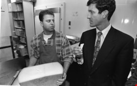
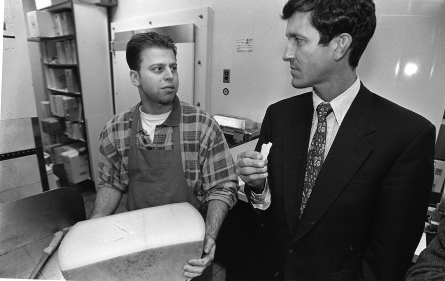
Svend Robinson with Rino Cioffi
https://search.heritageburnaby.ca/link/archivedescription79140
- Repository
- City of Burnaby Archives
- Date
- April 24, 1996
- Collection/Fonds
- Burnaby NewsLeader photograph collection
- Description Level
- Item
- Physical Description
- 1 photograph : b&w ; 15.5 x 23.5 cm
- Scope and Content
- Photograph of Burnaby-Kingsway MP Svend Robinson sampling cheeses with Rino Cioffi, owner of Cioffi's Meat Market and Deli on Hastings Street in Burnaby.
- Repository
- City of Burnaby Archives
- Date
- April 24, 1996
- Collection/Fonds
- Burnaby NewsLeader photograph collection
- Physical Description
- 1 photograph : b&w ; 15.5 x 23.5 cm
- Description Level
- Item
- Record No.
- 535-0277
- Access Restriction
- No restrictions
- Reproduction Restriction
- No reproduction permitted
- Accession Number
- 2012-11
- Scope and Content
- Photograph of Burnaby-Kingsway MP Svend Robinson sampling cheeses with Rino Cioffi, owner of Cioffi's Meat Market and Deli on Hastings Street in Burnaby.
- Subjects
- Officials - Elected Officials
- Names
- Robinson, Svend
- Cioffi, Rino
- Media Type
- Photograph
- Photographer
- Bartel, Mario
- Notes
- Title based on contents of photograph
- Note in black and blue ink on recto of photograph reads: "Bby 1 71% / 1043 Bby Mario"
- Trim marks and/or reproduction instructions on recto (scan is cropped)
Images
![West Burnaby Class, [1915 or 1916] thumbnail](/media/hpo/_Data/_BVM_Images/2012/2012_0020_0003_001.jpg?width=280)
West Burnaby Class
https://search.heritageburnaby.ca/link/museumdescription2940
- Repository
- Burnaby Village Museum
- Date
- [1915 or 1916]
- Collection/Fonds
- Burnaby Village Museum Photograph collection
- Description Level
- Item
- Physical Description
- 1 photograph : b&w ; 18 x 13 cm
- Scope and Content
- Photograph of a young class of students standing on the stairs of the school (most likely West Burnaby/Kingsway West School). There are four rows of students and a female teacher standing next to the third row.
- Repository
- Burnaby Village Museum
- Collection/Fonds
- Burnaby Village Museum Photograph collection
- Description Level
- Item
- Physical Description
- 1 photograph : b&w ; 18 x 13 cm
- Material Details
- Written on the reverse is "1936 / 21 / 1915 or 1916 / 3rd up Boys, Simpson, _____, Hopper, / 2nd up, Russell, Ludwig__ Dorris Faullmer (?), / (illegable writing) / Dorothy Taylor".
- Scope and Content
- Photograph of a young class of students standing on the stairs of the school (most likely West Burnaby/Kingsway West School). There are four rows of students and a female teacher standing next to the third row.
- Subjects
- Occupations - Teachers
- Persons - Students
- Names
- Kingsway West School
- Geographic Access
- Kingsway
- Street Address
- 4800 Kingsway
- Accession Code
- BV012.20.3
- Access Restriction
- No restrictions
- Reproduction Restriction
- No known restrictions
- Date
- [1915 or 1916]
- Media Type
- Photograph
- Historic Neighbourhood
- Central Park (Historic Neighbourhood)
- Planning Study Area
- Maywood Area
- Scan Resolution
- 600
- Scan Date
- 13-Mar-2018
- Notes
- Title based on contents of photograph
Images
![West Burnaby Class, [1915 or 1916] thumbnail](/media/hpo/_Data/_BVM_Images/2012/2012_0020_0003_001.jpg)