Narrow Results By
Decade
- 2020s 466
- 2010s 979
- 2000s 2815
- 1990s 4534
- 1980s 3032
- 1970s 5026
- 1960s 2377
- 1950s 2542
- 1940s 2396
- 1930s 2311
- 1920s 2752
- 1910s 2173
- 1900s 988
- 1890s 298
- 1880s 148
- 1870s 42
- 1860s
- 1850s 25
- 1840s 13
- 1830s 9
- 1820s 9
- 1810s 6
- 1800s 6
- 1790s 5
- 1780s 5
- 1770s 5
- 1760s 5
- 1750s 5
- 1740s 5
- 1730s 5
- 1720s 5
- 1710s 5
- 1700s 5
- 1690s 5
- 1680s 5
- 1670s 4
- 1660s 4
- 1650s 4
- 1640s 4
- 1630s 4
- 1620s 4
- 1610s 4
- 1600s 4
- 1590s 1
- 1580s 1
- 1570s 1
- 1560s 1
- 1550s 1
- 1540s 1
- 1530s 1
- 1520s 2
- 1510s 1
- 1500s 1
- 1490s 1
- 1480s 1
Subject
- Buildings - Commercial - Grocery Stores 1
- Buildings - Industrial - Factories 1
- Buildings - Industrial - Saw Mills 1
- Documentary Artifacts - Newspapers 2
- Education 1
- Employment 1
- Geographic Features - Parks 2
- Industries - Logging/lumber 1
- Land Clearing 1
- Migration 1
- Occupations - Engineers 1
- Occupations - Millworkers 1
Columbian Newspaper subseries
https://search.heritageburnaby.ca/link/archivedescription97177
- Repository
- City of Burnaby Archives
- Date
- [1865]-1983
- Collection/Fonds
- Burnaby Historical Society fonds
- Description Level
- Subseries
- Physical Description
- Photographs
- Scope and Content
- Subseries consists of photographs from the Columbian Newspaper collected by the Burnaby Historical Society.
- Repository
- City of Burnaby Archives
- Date
- [1865]-1983
- Collection/Fonds
- Burnaby Historical Society fonds
- Subseries
- Columbian Newspaper subseries
- Physical Description
- Photographs
- Description Level
- Subseries
- Accession Number
- BHS1989-19
- Scope and Content
- Subseries consists of photographs from the Columbian Newspaper collected by the Burnaby Historical Society.
- Media Type
- Photograph
- Creator
- The Columbian
- Notes
- Title based on contents of subseries
- PC 222
- History/Bio adapted from New Westminster Archives
Les miserables
https://search.heritageburnaby.ca/link/museumlibrary1880
- Repository
- Burnaby Village Museum
- Author
- Hugo, Víctor, 1802-1885
- Publication Date
- c1862
- Call Number
- 843.7 HUG
- Repository
- Burnaby Village Museum
- Collection
- Special Collection
- Material Type
- Book
- Accession Code
- HV982.24.16
- Call Number
- 843.7 HUG
- Author
- Hugo, Víctor, 1802-1885
- Place of Publication
- Toronto
- Publisher
- The Copp Clark Co., Ltd.
- Publication Date
- c1862
- Printer
- Collins' Clear-Type Press
- Physical Description
- 900 p. : ill.
- Inscription
- "471", in pencil on back of front endpaper "622-23", in pencil on back of front endpaper "F.B. Street / 6176 WALKER AVE. / BURNABY 1, B.C.", stamped in black on fly-leaf "1.50 / 7se", in pencil on last blank page
- Library Subject (LOC)
- Fiction--19th century
Elsie's holidays at Roselands
https://search.heritageburnaby.ca/link/museumlibrary3573
- Repository
- Burnaby Village Museum
- Author
- Finley, Martha, 1828-1909
- Publication Date
- c1868
- Call Number
- 813.4 FIN
- Repository
- Burnaby Village Museum
- Collection
- Special Collection
- Material Type
- Book
- Accession Code
- BV997.45.17
- Call Number
- 813.4 FIN
- Author
- Finley, Martha, 1828-1909
- Place of Publication
- London
- Publisher
- George Routledge And Sons, Ltd.
- Publication Date
- c1868
- Series
- The Elsie books
- Printer
- W. Jolly & Sons
- Physical Description
- 373 p. : 20 cm.
- Library Subject (LOC)
- Christian life
- Families
- Juvenile fiction
- Historic Neighbourhood
- East Burnaby (Historic Neighbourhood)
- Geographic Access
- Cumberland Street
- Object History
- This artifact has been passed down to all the girls in subsequent generations of the family, eventually to the donor, Mrs. Whiting. This series of 26 "Elsie" girls books are said, by the donor, to have been purchased by Jesse Love and his son in law Wallace (Flash) Whiting for the youngest of Jesse and Martha Love's children Hannah Victoria (Girlie) Love, age 10 at the time, and Annie (Love) Whiting's daughter Edith, age 8 at the time. The book series seems to have made their way through some of Jesse Love's daughter's children. Mrs. Whiting. Sarah (Love) Parker, daughter of Jesse Love, even named her daughter Elsie (Parker) Hughes after the main character of the series. The books seem to have made their way through the children and grand children of Annie (Love) and Wallace Whiting. The were donated by Edna Whiting, the daughter in law of Alfred Whiting, one of Annie's sons.
Mr and Mrs V Edmonds
https://search.heritageburnaby.ca/link/museumdescription4779
- Repository
- Burnaby Village Museum
- Date
- 1868
- Collection/Fonds
- Burnaby Village Museum Photograph collection
- Description Level
- Item
- Physical Description
- 1 photograph : b&w ; 12.6 x 8.8 cm ; copy print
- Scope and Content
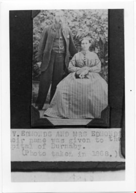
- Portrait of married couple, he standing, she sitting, in front of some shrubbery.
- Repository
- Burnaby Village Museum
- Collection/Fonds
- Burnaby Village Museum Photograph collection
- Description Level
- Item
- Physical Description
- 1 photograph : b&w ; 12.6 x 8.8 cm ; copy print
- Material Details
- "Columbian files 1971" written on verso in black pen. "V. EDMONDS AND MRS EDMONDS / […]eir name was given to the / Capital of Burnaby. / (Photo taken in 1868.)" on typewritten label on front of photograph.
- Scope and Content
- Portrait of married couple, he standing, she sitting, in front of some shrubbery.
- History
- Part of a set of photographs from the Columbian Newspaper, which operated out of New Westminster under this name starting in 1900 until its dissolution in 1988. Photographs found in the collection of the Burnaby Village are dated 1971.
- Other Title Information
- title based on note on front of photograph
- Accession Code
- BV018.19.5
- Access Restriction
- No restrictions
- Reproduction Restriction
- May be restricted by third party rights
- Date
- 1868
- Media Type
- Photograph
- Scan Resolution
- 600
- Scan Date
- 24-04-2018
Images
Book reading given by Pixie McGeachie January 10, 1973 - Track 5
https://search.heritageburnaby.ca/link/oralhistory241
- Repository
- City of Burnaby Archives
- Date Range
- 1868-1872
- Length
- 0:09:07
- Summary
- This portion of the recording pertains to Pixie McGeachie's continued reading of "Archdeacon on Horseback" by Canon Cyril E.H. Williams and herself. This section of the reading describes Reverend John Booth Good's first years serving as a missionary in and around Lytton, British Columbia, including…
- Repository
- City of Burnaby Archives
- Summary
- This portion of the recording pertains to Pixie McGeachie's continued reading of "Archdeacon on Horseback" by Canon Cyril E.H. Williams and herself. This section of the reading describes Reverend John Booth Good's first years serving as a missionary in and around Lytton, British Columbia, including the unhappy event of the death of his daughter.
- Date Range
- 1868-1872
- Photo Info
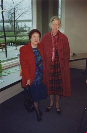
- Pixie McGeachie (left) and Florence Godwin, 1992. Item no. 330-003
- Length
- 0:09:07
- Interview Date
- January 10, 1973
- Scope and Content
- Recording is of a book reading given by Pixie McGeachie on January 10, 1973 to the Burnaby Historical Society from the book "Archdeacon on Horseback" by Canon Cyril E.H. Williams (then archivist in the Vancouver School of Theology, University of British Columbia) and Pixie McGeachie.
- Biographical Notes
- Doreen "Pixie" (Johnson) McGeachie was a resident of Burnaby for over sixty years. Pixie married John Aloysius "Jack" McGeachie and raised their children Kathi (Dunlop) and David McGeachie in the house the couple built themselves in 1947. Pixie served as the editor for the Burnaby Examiner newspaper and wrote a column entitled "Burnaby History" for The News. In 1974 she authored her first book titled "Bygones of Burnaby" which was one of the first to develop anecdotal stories about pioneer life in Burnaby. She authored "Burnaby - A Proud Century" in 1992 and in 2002 she wrote a biography of the city's namesake in the book "Land of Promise: Robert Burnaby's letters from Colonial B.C." She also contributed many hours of volunteering; helping to establish Burnaby's first museum Heritage Village in 1971, serving as President of the Burnaby Historical Society from 1991-1993. She served a six year term on Burnaby's Heritage Commission leading the charge to preserve many historic sites throughout the city, and during her twenty years as the Community Archives volunteer archivist for the historical society, she succeeded in gathering thousands of rare and valuable historic photographs and documents which now forms the core of the photograph collection on the Heritage Burnaby website (as these items were donated by the Society to the City Archives in 2007). The City of Burnaby awarded Pixie McGeachie the Kushiro Cup as Citizen of the year in 2002. In 2006 she received a Heritage BC project award for leading the Friends of Interurban 1223 project, and in 2008 Heritage BC recognised her again by presenting her with the Ruby Nobb Award. John Aloysius "Jack" McGeachie died October 12, 1981 at the age of sixty-seven. Doreen "Pixie" (Johnson) McGeachie died August 14, 2010 at the age of eighty-nine.
- Total Tracks
- 6
- Total Length
- 0:54:31
- Interviewee Name
- McGeachie, Doreen “Pixie”
- Collection/Fonds
- Burnaby Historical Society fonds
- Subseries
- Oral history subseries
- Media Type
- Sound Recording
- Web Notes
- Interview was digitized in 2010 allowing it to be accessible on Heritage Burnaby. The digitization project was initiated by the Community Heritage Commission with support from City of Burnaby Council and the BC History Digitization Program of the Irving K. Barber Learning Centre, University of British Columbia. It was recognized by the Heritage Society of BC with an award in 2012.
Images
Audio Tracks
Track five of recording of a book reading given by Pixie McGeachie
Track five of recording of a book reading given by Pixie McGeachie
https://search.heritageburnaby.ca/media/hpo/_Data/_Archives_Oral_Histories/_Unrestricted/MSS137-017-2/MSS137-017-2_Track_5.mp3Legal document and certificate series
https://search.heritageburnaby.ca/link/archivedescription166
- Repository
- City of Burnaby Archives
- Date
- [1867-1961]
- Collection/Fonds
- Peers Family and Hill Family fonds
- Description Level
- Series
- Physical Description
- 2 cm textual records
- Scope and Content
- Series consists of legal documents including as wills, birth certificates and military papers pertaining to Claude Hill and Annie Sara (Kenrick) Hill. Documents also include a diary kept by Claude, a few pieces of correspondence, ledgers related to Claude's land transactions and certificates of ci…
- Repository
- City of Burnaby Archives
- Date
- [1867-1961]
- Collection/Fonds
- Peers Family and Hill Family fonds
- Physical Description
- 2 cm textual records
- Description Level
- Series
- Access Restriction
- No restrictions
- Reproduction Restriction
- May be restricted by third party rights
- Accession Number
- 2007-12
- Scope and Content
- Series consists of legal documents including as wills, birth certificates and military papers pertaining to Claude Hill and Annie Sara (Kenrick) Hill. Documents also include a diary kept by Claude, a few pieces of correspondence, ledgers related to Claude's land transactions and certificates of citizenship and identification. Also in the file is a sketch showing a “Birds Eye View of the Burnaby Lake Area circa 1910,” a book of Common Prayer Hymns, a Bible, a Post Card Album, address book, a Birthday Book and a cross-stitch sampler done by Annie Kenrick in 1877.
- Media Type
- Textual Record
Book reading given by Pixie McGeachie January 10, 1973 - Track 4
https://search.heritageburnaby.ca/link/oralhistory240
- Repository
- City of Burnaby Archives
- Date Range
- 1867-1868
- Length
- 0:09:11
- Summary
- This portion of the recording pertains to Pixie McGeachie's continued reading of "Archdeacon on Horseback" by Canon Cyril E.H. Williams and herself. This section of the reading describes Reverend John Booth Good's first years serving as a missionary at Lytton, British Columbia.
- Repository
- City of Burnaby Archives
- Summary
- This portion of the recording pertains to Pixie McGeachie's continued reading of "Archdeacon on Horseback" by Canon Cyril E.H. Williams and herself. This section of the reading describes Reverend John Booth Good's first years serving as a missionary at Lytton, British Columbia.
- Date Range
- 1867-1868
- Photo Info
- Pixie McGeachie (left) and Florence Godwin, 1992. Item no. 330-003
- Length
- 0:09:11
- Interview Date
- January 10, 1973
- Scope and Content
- Recording is of a book reading given by Pixie McGeachie on January 10, 1973 to the Burnaby Historical Society from the book "Archdeacon on Horseback" by Canon Cyril E.H. Williams (then archivist in the Vancouver School of Theology, University of British Columbia) and Pixie McGeachie.
- Biographical Notes
- Doreen "Pixie" (Johnson) McGeachie was a resident of Burnaby for over sixty years. Pixie married John Aloysius "Jack" McGeachie and raised their children Kathi (Dunlop) and David McGeachie in the house the couple built themselves in 1947. Pixie served as the editor for the Burnaby Examiner newspaper and wrote a column entitled "Burnaby History" for The News. In 1974 she authored her first book titled "Bygones of Burnaby" which was one of the first to develop anecdotal stories about pioneer life in Burnaby. She authored "Burnaby - A Proud Century" in 1992 and in 2002 she wrote a biography of the city's namesake in the book "Land of Promise: Robert Burnaby's letters from Colonial B.C." She also contributed many hours of volunteering; helping to establish Burnaby's first museum Heritage Village in 1971, serving as President of the Burnaby Historical Society from 1991-1993. She served a six year term on Burnaby's Heritage Commission leading the charge to preserve many historic sites throughout the city, and during her twenty years as the Community Archives volunteer archivist for the historical society, she succeeded in gathering thousands of rare and valuable historic photographs and documents which now forms the core of the photograph collection on the Heritage Burnaby website (as these items were donated by the Society to the City Archives in 2007). The City of Burnaby awarded Pixie McGeachie the Kushiro Cup as Citizen of the year in 2002. In 2006 she received a Heritage BC project award for leading the Friends of Interurban 1223 project, and in 2008 Heritage BC recognised her again by presenting her with the Ruby Nobb Award. John Aloysius "Jack" McGeachie died October 12, 1981 at the age of sixty-seven. Doreen "Pixie" (Johnson) McGeachie died August 14, 2010 at the age of eighty-nine.
- Total Tracks
- 6
- Total Length
- 0:54:31
- Interviewee Name
- McGeachie, Doreen “Pixie”
- Collection/Fonds
- Burnaby Historical Society fonds
- Subseries
- Oral history subseries
- Media Type
- Sound Recording
- Web Notes
- Interview was digitized in 2010 allowing it to be accessible on Heritage Burnaby. The digitization project was initiated by the Community Heritage Commission with support from City of Burnaby Council and the BC History Digitization Program of the Irving K. Barber Learning Centre, University of British Columbia. It was recognized by the Heritage Society of BC with an award in 2012.
Images
Audio Tracks
Track four of recording of a book reading given by Pixie McGeachie
Track four of recording of a book reading given by Pixie McGeachie
https://search.heritageburnaby.ca/media/hpo/_Data/_Archives_Oral_Histories/_Unrestricted/MSS137-017-2/MSS137-017-2_Track_4.mp3
Douglas Road
https://search.heritageburnaby.ca/link/landmark714
- Repository
- Burnaby Heritage Planning
- Associated Dates
- 1865
- Heritage Value
- Douglas Road was built between 1862-1865 by the Royal Engineers based in New Westminster. Originally known as the Douglas Street Trail, it took its name from Governor James Douglas. In 1926 a new connection was made to reach Grandview Road in Vancouver at Boundary Road. To distinguish this new highway it was renamed the Grandview Highway and it became commonly known as the combined Grandview-Douglas Highway until 1968 when the Burnaby and New Westminister sections were renamed Canada Way, in recognition of Canada's Centennial in 1967. The old part of Douglas Road north of Sprott Street remained intact.
- Historic Neighbourhood
- Burnaby Lake (Historic Neighbourhood)
- Planning Study Area
- Douglas-Gilpin Area
- Street View URL
- Google Maps Street View
Images

![Robert Burnaby, [1865] (date of original), copied August 12, 1975 thumbnail](/media/hpo/_Data/_Archives_Images/_Unrestricted/205/222-013.jpg?width=280)
Robert Burnaby
https://search.heritageburnaby.ca/link/archivedescription36090
- Repository
- City of Burnaby Archives
- Date
- [1865] (date of original), copied August 12, 1975
- Collection/Fonds
- Burnaby Historical Society fonds
- Description Level
- Item
- Physical Description
- 1 photograph : b&w ; 21.5 x 14.5 cm print
- Scope and Content
- Photograph of Robert Burnaby standing indoors.
- Repository
- City of Burnaby Archives
- Date
- [1865] (date of original), copied August 12, 1975
- Collection/Fonds
- Burnaby Historical Society fonds
- Subseries
- Columbian Newspaper subseries
- Physical Description
- 1 photograph : b&w ; 21.5 x 14.5 cm print
- Description Level
- Item
- Record No.
- 222-013
- Access Restriction
- No restrictions
- Reproduction Restriction
- No known restrictions
- Accession Number
- BHS1989-19
- Scope and Content
- Photograph of Robert Burnaby standing indoors.
- Names
- Burnaby, Robert
- Media Type
- Photograph
- Notes
- Title based on contents of photograph
- Note on verso of print: from a newspaper article briefly describing Robert Burnaby's life
Images
![Robert Burnaby, [1865] (date of original), copied August 12, 1975 thumbnail](/media/hpo/_Data/_Archives_Images/_Unrestricted/205/222-013.jpg)

Alfred Bingham's writings - Track 1
https://search.heritageburnaby.ca/link/oralhistory251
- Repository
- City of Burnaby Archives
- Date Range
- 1865-1919
- Length
- 0:10:18
- Summary
- This portion of the recording includes Alfred Bingham's essay entitled Stump Rangers, a listing of early settlers that includes addresses and short descriptions, essays on Confederation Park, land clearing and on Burnaby's first Council meeting.
- Repository
- City of Burnaby Archives
- Summary
- This portion of the recording includes Alfred Bingham's essay entitled Stump Rangers, a listing of early settlers that includes addresses and short descriptions, essays on Confederation Park, land clearing and on Burnaby's first Council meeting.
- Date Range
- 1865-1919
- Photo Info
- Alfred Bingham, April 20, 1947. Item no. 010-066
- Length
- 0:10:18
- Scope and Content
- Recording is of Alfred Bingham's writings, as read by Alfred Bingham. Major themes discussed are: Pioneers, early days in Burnaby and the Co-op Movement. To view "Narrow By" terms for each track expand this description and see "Notes".
- Biographical Notes
- Alfred "Alf" Bingham was born in England in 1892 and moved to Canada in 1912. His first job in Canada was laying track for the Grand Trunk Pacific Railway (GTPR) from Edmonton to McBride in 1912. His second was in Vancouver at the Rat Portage Mill on False Creek, working on the Resaw machine. He quit after one week due to poor working conditions. After taking part in the 1919 Winnipeg General Strike as a delegate of the Retail and Mailorder Union (A.F.L.) on the Winnipeg Trades and Labour Council, Alfred moved to Burnaby where he and fellow Burnaby residents Aungus McLean and Percy Little worked ten hour days to build a Shingle Mill on the edge of Burnaby Lake for Simpson & Giberson. George Green, carpenter and millwright (author of “The History of Burnaby”) also helped in the construction of the mill. Alfred built his own home from lumber cut from the mill in the Lochdale area on Sherlock Street between Curtis Street and Kitchener Street. On April 10, 1920 Alfred married Mary Jane “Ada” Reynolds. Alfred and Ada often took in foster children during their marriage. Due to her nursing experience, Ada was often called upon to deliver babies in the Burnaby area. Alfred and Ada Bingham were instrumental members of the Army of the Common Good, collecting vegetables and grains from growers in the area and even producing over 125 tons of vegetables from its own gardens to feed children and youth suffering from the lack of resources during the Depression years. The army was in operation for ten years and during that time the members organised the Credit Union movement of British Columbia and drew up the Credit Union act thorough the Vancouver Co-operative Council. They also started Co-Op stores and the Co-Op Wholesale Society. Alfred was also Secretary of the Burnaby Housing committee and in 1946 he became the Secretary of the North Burnaby Labour Progressive Party (LPP). Mary Jane “Ada” (Reynolds) Bingham died on August 9, 1969. Her husband Alfred died on April 29, 1979.
- Total Tracks
- 12
- Total Length
- 1:38:06
- Interviewee Name
- Bingham, Alfred "Alf"
- Collection/Fonds
- Burnaby Historical Society fonds
- Subseries
- Oral history subseries
- Transcript Available
- MSS142-001 contains transcripts for each of the short stories
- Media Type
- Sound Recording
- Web Notes
- Interview was digitized in 2010 allowing it to be accessible on Heritage Burnaby. The digitization project was initiated by the Community Heritage Commission with support from City of Burnaby Council and the BC History Digitization Program of the Irving K. Barber Learning Centre, University of British Columbia. It was recognized by the Heritage Society of BC with an award in 2012.
Images

Audio Tracks
Track one of recording of Alfred Bingham's writings
Track one of recording of Alfred Bingham's writings
https://search.heritageburnaby.ca/media/hpo/_Data/_Archives_Oral_Histories/_Unrestricted/100-13-20-2/100-13-20-2_Track_1.mp3![Survey and Subdivision plans in New Westminster District Group 1 – Burnaby, Port Moody, [1862-1908] thumbnail](/media/hpo/_Data/_BVM_Cartographic_Material/1977/1977_0093_0026a_001.jpg?width=280)
Survey and Subdivision plans in New Westminster District Group 1 – Burnaby, Port Moody
https://search.heritageburnaby.ca/link/museumdescription6995
- Repository
- Burnaby Village Museum
- Date
- [1862-1908]
- Collection/Fonds
- Burnaby Village Museum Map collection
- Description Level
- File
- Physical Description
- 9 plans : 6 plans : black ink on paper ; 57 x 36.5 cm or smaller + 1 plan : black ink and grahite on paper ; 46.5 x 49 cm + 1 plan : blueprint on paper ; 15.5 x 19.5 cm + cm + 1 plan : graphite on paper ; 25 x 17 cm ; mounted on both sides of board 76 x 102 cm
- Scope and Content
- Item consists of a large board of four New Westminster District subdivision plans mounted on one side and five New Westminster District subdivision plans mounted on the other side. Side A: 1. "Plan / of Subdivision / of a Portion / of / Lot 87 / Group One / New Westminster District / Scale 4 chs…
- Repository
- Burnaby Village Museum
- Collection/Fonds
- Burnaby Village Museum Map collection
- Description Level
- File
- Physical Description
- 9 plans : 6 plans : black ink on paper ; 57 x 36.5 cm or smaller + 1 plan : black ink and grahite on paper ; 46.5 x 49 cm + 1 plan : blueprint on paper ; 15.5 x 19.5 cm + cm + 1 plan : graphite on paper ; 25 x 17 cm ; mounted on both sides of board 76 x 102 cm
- Material Details
- Scales [between 1:792 and 1:3600]
- Index number on edge of board reads: "26"
- Scope and Content
- Item consists of a large board of four New Westminster District subdivision plans mounted on one side and five New Westminster District subdivision plans mounted on the other side. Side A: 1. "Plan / of Subdivision / of a Portion / of / Lot 87 / Group One / New Westminster District / Scale 4 chs = 1 in". Plan is stamped: "Albert J. Hill, Civil Engineer / and / Provincial Land Surveyor, / New Westminster, / B.C." and intialed by: "RB" [sic] (in blue pencil crayon). Names two of the subdivisons of District Lot 87 are identified as, "L.E. Sprott" and "John Ledger". (Geographic location: Burnaby) 2. "Plan of Subdivision / of / Portions of / Lot 136, 131 and Lots 44 and 78 Gr.1 / New Westminster District / Scale 300 ft = 1 inch". Annotation above title reads: "No. 901 / Deposited in Land Registry Office / New Westminster / Aug. 19th 1905 / Charles S. Keith D. Reg." Annotations and signatures at bottom of plan read: "I, William Nelson Draper, / W.H.R. Collister / Charles E. Perkins / E.B. Morgan / make / Surveys / correct / representation / upon / the / Land Registry Act / (sgd) W.N. Draper, P.L.S.". Plan includes a handwritten title: "Lots 136, 131, 44 & 78" and is initialed: "RB" [sic] (in blue pencil crayon) (Geographic location: Burnaby) 3. "Survey / of / a Portion / of / Lot 95, Gr.1 / Scale 1 ch = 1in." Plan is stamped: "Albert J. Hill, Civil Engineer / and / Provincial Land Surveyor, / New Westminster, / B.C." and is initialed : "RB" [sic] (in blue pencil crayon) (Geographic location: Burnaby) 4. Blueprint plan of "Lot 396. Group One." with Scale : 3 chs = 1 in. A two acre portion of District Lot 396 is filled in with red ink." Plan is signed by "Albert J. Hill / B.C.L.S." (Geographic location: Port Moody) Side B: 1. Plan titled "District Lot 92 / Burnaby / Municipality / for sale by / Mahon / McFarland & / Mahon Ltd. / Vancouver, B.C. / Scale : 4 chains to one inch". District Lot 92 is subdivided into 161 lots and identifies roads: Norwich Road, Pole Line Road, Oakland Road, Stanley Road, Burford Road, Dalhousie Road, Brantford Road, Colborne Road, Roberts Road, Vancouver & Westminster Road, B.C. Electric Railway, Gilley Stn. and Burnaby (Power House). The bottom of the plan reads: "G.S. Dawson, P.LS. Vancouver, B.C." (Geographic location: Burnaby) 2. "Plan / of Subdivision / of a Portion / of / Lot 29 / Group 1 / New Westminster District / Scale 2 chs = 1 in". Plan is stamped: "Albert J. Hill, Civil Engineer / and / Provincial Land Surveyor, / New Westminster, / B.C." and is initialed by: "RB" [sic] (in blue pencil crayon) (Geographic location: Burnaby) 3. Small handrawn plan (no title) identifying "Lot 84 / Hydes, Claim" at the centre surrounded by lots and features identified as: "Lot 85", "Lot 93", "Lot 94", "Lot 32", "Lot 82", "Lot 83", "Lot 79", "swamp" and a "Small Lake" (Burnaby Lake). Identifying marks in the right corner of the plan read: "Page 13 / Surveyed by G. Turner / May 62". Plan also includes surveyor's bearing measurements and trails to "Small Lake" (Burnaby Lake). (Geographic location: Burnaby) 4. Untitled plan showing District Lots west of North Road and north of Burnaby Lake including: Lots 2, 4, 6, 8, 15, 10, 56, 148, 57, 58, 40. and Lots 3, 5, 7 east of North Road (Coquitlam). Lots in Burnaby are identifed for timber including: "Heavily Timbered" (Lot 57), " "Some Fir and Cedar" (Lot 40), "Splendid Fir and Cedar" (Lot 143), "Heavy Fir etc" (Lots 143 and 148), " "Fine Cedar" (Lot 15), "Rough Light Timber" (Lot 56). Other features identified at the lower portion of the plan include "Burnaby Lake" and "Brunette River". (Geographic location: Burnaby) 5. Untitled plan drawn in graphite showing sections of District Lot 85 south of Burnaby Lake and north of Hazsard Road. Plan is signed: "Albert J. Hill / B.C.L.S." and dated "12/26/08". Plan is initialed by: "RB" [sic] (in blue pencil crayon) (Geographic location: Burnaby)
- Publisher
- Mahon, McFarland & Mahon Ltd
- Accession Code
- HV977.93.26
- Access Restriction
- No restrictions
- Reproduction Restriction
- No known restrictions
- Date
- [1862-1908]
- Media Type
- Cartographic Material
- Historic Neighbourhood
- Burnaby Lake (Historic Neighbourhood)
- Burquitlam (Historic Neighbourhood)
- Planning Study Area
- Burnaby Lake Area
- Scan Resolution
- 300
- Scale
- 72
- Notes
- Title based on contents of file
- Scale is measured in chains and feet. (One chain equals 792 inches)
- The term "Lot" can also refer to a "District Lot”
Images
![Survey and Subdivision plans in New Westminster District Group 1 – Burnaby, Port Moody, [1862-1908] thumbnail](/media/hpo/_Data/_BVM_Cartographic_Material/1977/1977_0093_0026a_001.jpg)


![Survey and Subdivision plans in New Westminster District Group 1 – Burnaby
, [1861]-[1910] thumbnail](/media/hpo/_Data/_BVM_Cartographic_Material/1977/1977_0093_0019a_001.jpg?width=280)
Survey and Subdivision plans in New Westminster District Group 1 – Burnaby
https://search.heritageburnaby.ca/link/museumdescription6988
- Repository
- Burnaby Village Museum
- Date
- [1861]-[1910]
- Collection/Fonds
- Burnaby Village Museum Map collection
- Description Level
- File
- Physical Description
- 14 plans : 3 plans : black ink on paper hand col. + 7 plans : black ink on paper + 4 plans : graphite on paper mounted on 2 sides of cardboard 76 x 102 cm
- Scope and Content
- Item consists of a large board of four New Westminster District Gp 1 - subdivision plans mounted on one side and ten New Westminster District Gp 1 - subdivision plans mounted on the other side. Side A: 1. "Plan /of / Lots 166A, 166 and 167 /, Gr.1, N.W.D. / Showing Misconstructed Roads in Gree…
- Repository
- Burnaby Village Museum
- Collection/Fonds
- Burnaby Village Museum Map collection
- Description Level
- File
- Physical Description
- 14 plans : 3 plans : black ink on paper hand col. + 7 plans : black ink on paper + 4 plans : graphite on paper mounted on 2 sides of cardboard 76 x 102 cm
- Material Details
- Scales [between 1:2376 and 1:7920]
- Index number on edge of board reads: "19"
- Scope and Content
- Item consists of a large board of four New Westminster District Gp 1 - subdivision plans mounted on one side and ten New Westminster District Gp 1 - subdivision plans mounted on the other side. Side A: 1. "Plan /of / Lots 166A, 166 and 167 /, Gr.1, N.W.D. / Showing Misconstructed Roads in Green / 5 chs = 1 in.". (plan is drawn in black ink and hand coloured in red, green and orange ink). A section in the centre of the plan is coloured in red ink and identified as "C.S. Richmond" running from the North Arm of Fraser River to Wiggins Road and divided by "New Wiggins Rd. (as gazetted)" (coloured in orange ink) and two"Constructed Road(s)" (coloured in green ink). Plan is initialed by: "RB" [sic] (in blue pencil crayon) 2. Plan of / Subdivision of / Lot 166 / Group One / New Westminster District / Scale 4 chs = 1 in. / Map No 524". Plan is drawn in graphite and signed by "Surrig [sic] Welhams [sic] / P.L.S." Plan is initialed by: "RB" [sic] (in blue pencil crayon) 3. Plan of "Survey / of Highway / For / Burnaby Council / in / Lots 13 _14 / Group One / Scale 4 chs = 1 in." Signed by "Albert J. Hill, P.L.S." Caribou Street and Caribou Road run through the centre of the plan. Plan is stamped: "Albert J. Hill, Civil Engineer / and / Provincial Land Surveyor, / New Westminster, / B.C.". Plan is initialed by: "RB" [sic] (in blue pencil crayon) 4. A Plan of Lots 166A, 166 and 167, Group One, New Westminster District (drawn in graphite). A section in the centre of the plan is identified as "C.S. Richmond" running from the North Arm of Fraser River and divided by "New Wiggins Rd. (as gazetted)" and two "Constructed Road(s)". Plan is initialed by: "RB" [sic] (in blue pencil crayon) Side B: 1. Small plan drawn in black ink (no title) identifying lots north of the "North Arm" of the Fraser River. Lots identified include: Lot 99, Lot 98, Lot 157, Lot 158, Lot 163, Lot 162, Lot 159, Lot 163, Lot 162, Lot 165, Lot 166A, Lot 155B, Lot 155A and Lot 159. "Scale 40 chains to one inch" . Plan is initialed by: "RB" [sic] (in blue pencil crayon) (Geographic location: Burnaby) 2. Small plan drawn in black ink (no title) identifying lots north of the North Arm of the Fraser River as "Lots 155, 155A, 155B, 155C, 162, 163, 164, 165, 166A and 167". Plan is initialed by: "RB" [sic] (in blue pencil crayon) (Geographic location: Burnaby) 3. Small plan drawn in black ink (no title) which identifies "Lot 151 / Reserve/ for / Race Course"; "Reserve / 64 A / L. 152 G.1"; and other Lots: 32, 33, 34, 35, 36, 38, 39. The plan is signed "Surveyor G.Turn [sic] July / 61 / from Vol 40 R.L. notes [sic]" Plan is stamped: "Albert J. Hill, Civil Engineer / and / Provincial Land Surveyor, / New Westminster, / B.C." Plan is initialed by: "RB" [sic] (in blue pencil crayon) (Geographic location: Burnaby) 4. Small plan drawn in black in with faded red colouring on centre lot identified as "Lot 34" running north from "Vancouver Road" . Plan is stamped: "Albert J. Hill, Civil Engineer / and / Provincial Land Surveyor, / New Westminster, / B.C." Plan is initialed by: "RB" [sic] (in blue pencil crayon) (Geographic location: Burnaby) 5. Plan drawn in graphite and identified as "Lot 98, Gr.1," along with the intials "RB" [sic] (both are handwritten in blue crayon pencil on top of plan) The B.C.E.Railway is identified running through the plan along with Jubilee Road and Royal Oak Road. The plan is signed with the name "Wm. Murray" and the Plan is stamped: "Albert J. Hill, Civil Engineer / and / Provincial Land Surveyor, / New Westminster, / B.C.". (Geographic location: Burnaby) 6. Plan drawn in graphite identified as "Port Lot 13, Gr.1" along with the intials "RB" [sic] (both are handwritten in blue crayon pencil on top of plan) Plan is stamped: "Albert J. Hill, Civil Engineer / and / Provincial Land Surveyor, / New Westminster, / B.C.". (Geographic location: Burnaby) 7.Plan drawn in black ink and identified as "Lot 98 G.1" along with the intials "RB" [sic] (both are handwritten in blue crayon pencil on top of plan). A "Road Reservation" is identified running north between "Electric Tramway" and connecting with "Royal Oak Road". Plan is stamped: "Albert J. Hill, Civil Engineer / and / Provincial Land Surveyor, / New Westminster, / B.C." (Geographic location: Burnaby) 8. Plan drawn in black ink and divided into two sections, the upper plan is identified as "Portion / Lots 100 / area / 101, Gr.1" and the lower plan is identified as "Portion L. 3 G. 1" along with the intials "RB" [sic] (these identifiers are handwritten in blue crayon pencil on top of the plan). Portions of Lot 100 and Lot 101 are each divided into 6 sections and the Portion of Lot 3 plan is divided into 24 sections. The plan includes a note in black ink that reads: " Received from Wm Fromme [sic] / from Wm. Trapp / Nov. 28, 1895 / A. J. T...[sic]". (Geographic location: Burnaby) 9. Plan drawn in black ink (no title) identifying soil, buildings and geographic features in southern Burnaby. The plan is bordered by "New Westminster City" (Tenth Avenue and DL 172) to the south east and DL 173 to the south, DL 158 to the west and the B.C.E. Tramway to the north. Plan includes District Lots: 155A, 158, 159, 171, 160, 53 and 95 and identifies soil, marshland and ravines throughout. Plan identifies the following features: a "Team Road" running through Lots 158 and 159 along with "Fair Orchard Soil / Even Surface Throughout / No Ravines", "Gravel and Shingle" (bottom of Lot 158), "North Arm Road" crossing "Byrne Road" and connecting with "Power House Road" which runs north to connect with "Highland Park Station" and the B.C.E. Tramway, "Power Ho" in the northeast corner of DL 160, a "Brook" connected with a "Deep Ravine" running between DL 53, DL 95 and DL 160 along with "Good Soil" and "Fair Orchard Soil" identified nearby in DL 95. Scale is identified as "10 chs = 1 in." Plan is stamped: "Albert J. Hill, Civil Engineer / and / Provincial Land Surveyor, / New Westminster, / B.C." Plan is initialed by: "RB" [sic] (in blue pencil crayon) (Geographic location: Burnaby) 10. Plan drawn in black ink (no title) with Burnaby Lake and Deer Lake at the centre. The plan is bordered by the following District Lots identified as: 117, 118 and 68 to the west, Lots 80, 79 and 85 to the southwest, Lots 11, 13, and 1 (City of New Westminster) to the south east, the North Road boundary to the east and Lots 8, 56, 57, 59, and 136 to the North. The lower right hand corner of the plan has a small inset which reads: "Burnaby Lake" and "Page 19 R.B. Notes". Plan is initialed by: "RB" [sic] (in blue pencil crayon) (Geographic location: Burnaby)
- Creator
- Hill, Albert James
- Accession Code
- HV977.93.19
- Access Restriction
- No restrictions
- Reproduction Restriction
- No known restrictions
- Date
- [1861]-[1910]
- Media Type
- Cartographic Material
- Scan Resolution
- 300
- Scale
- 72
- Notes
- Title based on contents of file
- Scale is measured in chains. (One chain equals 792 inches)
- The term "Lot" can also refer to a "District Lot”
- Some plans are stamped: "Albert J. Hill, Civil Engineer / and / Provincial Land Surveyor, / New Westminster, / B.C." and intialed: "RB" [sic]
Images
![Survey and Subdivision plans in New Westminster District Group 1 – Burnaby
, [1861]-[1910] thumbnail](/media/hpo/_Data/_BVM_Cartographic_Material/1977/1977_0093_0019a_001.jpg)

Certificate of Title
https://search.heritageburnaby.ca/link/museumdescription10407
- Repository
- Burnaby Village Museum
- Date
- 20 Feb. 1861
- Collection/Fonds
- William Holmes fonds
- Description Level
- Item
- Physical Description
- 1 certificate
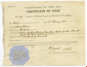
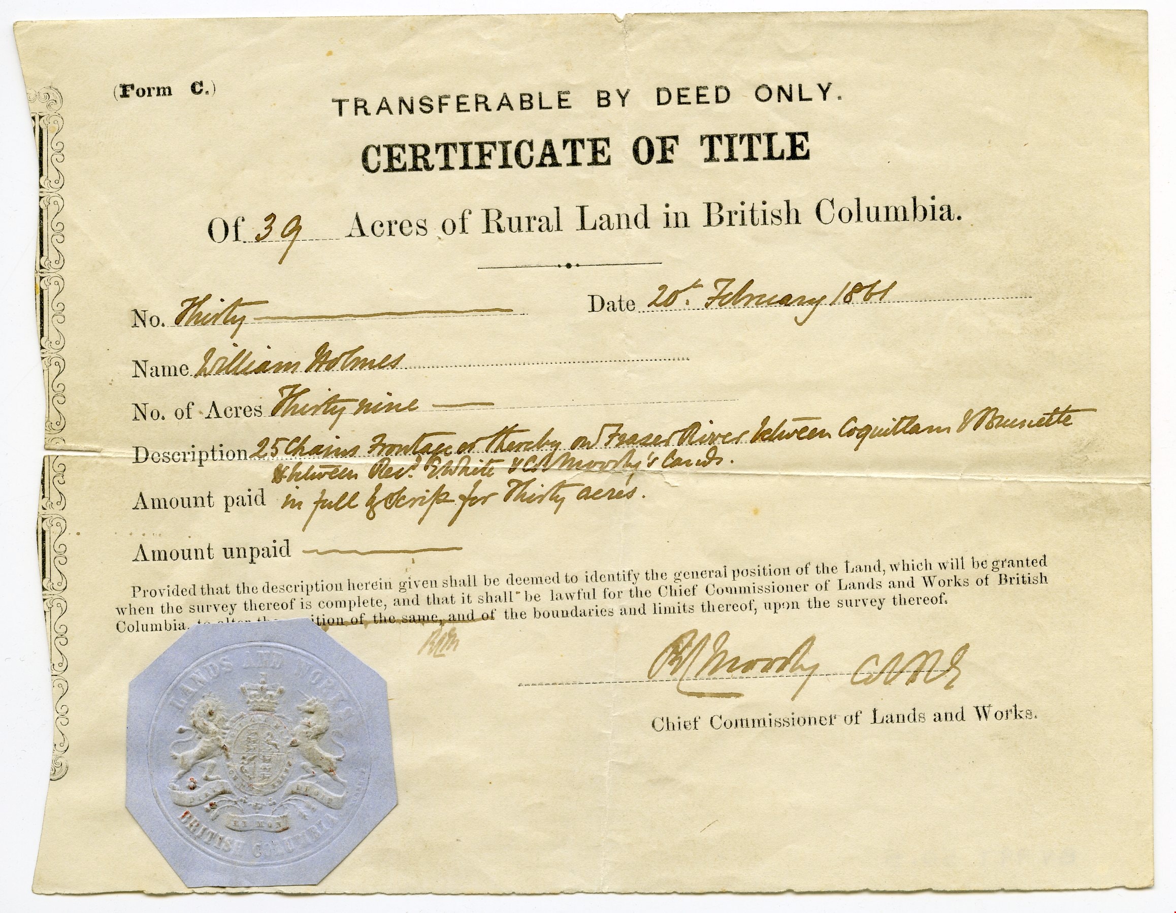
- Scope and Content
- Item consists of "Certificate of Title" to Mr. William Holmes for land in Burnaby/NE Westminster; "39 Acres", "20th February 1861". "Description" reads: "25 Chains Frontage on thereby on Fraser River between Coquitlam & Brunette / between Rev. E. White & Col. Moody's [?]". The blue Provincial seal…
- Repository
- Burnaby Village Museum
- Collection/Fonds
- William Holmes fonds
- Description Level
- Item
- Physical Description
- 1 certificate
- Scope and Content
- Item consists of "Certificate of Title" to Mr. William Holmes for land in Burnaby/NE Westminster; "39 Acres", "20th February 1861". "Description" reads: "25 Chains Frontage on thereby on Fraser River between Coquitlam & Brunette / between Rev. E. White & Col. Moody's [?]". The blue Provincial seal is affixed to the certificate and it is signed by R.C. Moody, "Chief Commissioner of Lands and Works".
- Accession Code
- BV997.50.5
- Access Restriction
- No restrictions
- Reproduction Restriction
- No known restrictions
- Date
- 20 Feb. 1861
- Media Type
- Textual Record
- Scan Resolution
- 300
- Scan Date
- 06-May-2019
- Notes
- Title based on contents of item
Images
William Randolph Beamish fonds
https://search.heritageburnaby.ca/link/archivedescription100653
- Repository
- City of Burnaby Archives
- Date
- 1861-2009
- Collection/Fonds
- William Randolph Beamish fonds
- Description Level
- Fonds
- Physical Description
- 3.5 cm. of textual records; 17 small b&w prints; 10 med. prints; and 6 large b&w prints.
- Scope and Content
- Fonds consists of materials related to both Ran's personal life and his professional life as Reeve of Burnaby. Included in the materials are records related to his biological family as well as his adopted family, including records related to his reunion with his birth mother. Notable among his prof…
- Repository
- City of Burnaby Archives
- Date
- 1861-2009
- Collection/Fonds
- William Randolph Beamish fonds
- Physical Description
- 3.5 cm. of textual records; 17 small b&w prints; 10 med. prints; and 6 large b&w prints.
- Description Level
- Fonds
- Record No.
- 66671
- Access Restriction
- No restrictions
- Accession Number
- 2018-08 2023-03
- Scope and Content
- Fonds consists of materials related to both Ran's personal life and his professional life as Reeve of Burnaby. Included in the materials are records related to his biological family as well as his adopted family, including records related to his reunion with his birth mother. Notable among his professional records are photographs and newspaper clippings documenting his meeting with Queen Elizabeth II during an official visit prior to her coronation.
- History
- William Randolph "Ran" Beamish was born in Warren, Ontario, on November 11, 1908. He was the child of Gertrude Applegate (nee Pearce) and Randolph Applegate, but when he was put in an orphanage at birth, he was adopted by William Beamish and Agnes Crabbe and raised as their only son. Agnes Crabbe was the daughter of James Crabbe and Emily Widger; Emily Widger was the daughter of Henry Widger and Agnes Oldridge. When Agnes Oldridge passed away, Henry Widger remarried Jessie (maiden name unknown) and had Gertrude, who later went on to give birth to Ran, meaning he was eventually adopted and raised by his first cousins. Ran married Marjorie Davies and had two children, Joanne Beamish and Donna Beamish. Ran served as the Reeve of Burnaby from 1950 to 1953. He died on January 2, 1965, in New Westminster at the age of 56.
- Media Type
- Textual Record
William John Beamish genealogical records
https://search.heritageburnaby.ca/link/archivedescription100656
- Repository
- City of Burnaby Archives
- Date
- 1861-1942
- Collection/Fonds
- William Randolph Beamish fonds
- Description Level
- File
- Physical Description
- 0.5 cm. of textual records and 1 large b&w print.
- Scope and Content
- File consists of family history records related to the Beamishes, William Randolph Beamish's adopted family, including a letter certifying the birth and baptism of William John Beamish on December 13, 1860, and June 9, 1861, respectively; a certificate for William John Beamish for the Probationers'…
- Repository
- City of Burnaby Archives
- Date
- 1861-1942
- Collection/Fonds
- William Randolph Beamish fonds
- Physical Description
- 0.5 cm. of textual records and 1 large b&w print.
- Description Level
- File
- Record No.
- 66674
- Access Restriction
- No restrictions
- Accession Number
- 2023-03
- Scope and Content
- File consists of family history records related to the Beamishes, William Randolph Beamish's adopted family, including a letter certifying the birth and baptism of William John Beamish on December 13, 1860, and June 9, 1861, respectively; a certificate for William John Beamish for the Probationers' Course of Study of the Methodist Church of Canada; sermon notes written by W.J. Beamish, as well as "his life as he wrote it”; a financial statement of Newington Circuit; his ordination picture; and obituaries for W.J. Beamish.
- History
- William John Beamish was born in Prescott, Ontario, on December 30, 1860. He was brought up and confirmed in the Anglican Church. While in his teens, he was attending a Methodist Church, became converted, and entered the same church as a candidate for the ministry. His probationary years were spent in the Northern Ontario lumber camps, ministering to the men on Lake Tallon Mission and Nipissing Junction. Mr. Beamish attended McGill College and after ordination at Smiths Falls, Ontario, on June 2, 1896, was appointed to Locksley circuit near Pembroke, then followed pastorates at Hammon, Mille Roches, Moulinette, Morewood, and Berwick. In 1905, while at Morewood, he married Miss Agnes Crabbe, a nurse from Ottawa, formerly Pembroke. Together, they served Wakefield, Quebec, Newington, and Easton's Corners, Ontario. Coming to British Columbia in 1911, they settled first at Kaslo, then Salmon Arm, Vancouver (Dundas), and Maple Ridge. In 1918, Mr. Beamish superannuated and bought a home in Burnaby where he resided until his death on July 26, 1942. During his period of superannuation, Mr. Beamish served for about seven years as minister of East Burnaby Methodist Church and until his death, was a valued member of this congregation, now known as East Burnaby United. He was ever a true friend of the minister and his presence in the congregation was an inspiration. While in good health, he gave his time freely to sick visitation and, in a word, "he went about doing good." Funeral services were conducted by Rev. W.R. Walkinshaw, with Rev. H.E. Horton representing Westminster Presbyterian assisting. Four retired ministers and two laymen acted as pall bearers. His reamins lie in Forest Lawn Memorial Park. He was survived by his wife; one son, Randolph; two daughters, Ethel (Mrs. Paul B. Derrick) and Ilma (Mrs. William Dunn). He was a good husband, a loving father, a dutiful son, and a faithful minister of the Gospel. -- This text was composed and written by Rev. R.W. Walkinshaw and later published in The Observer, the United Church magazine. It has been lightly edited here for grammar and punctuation.
- Media Type
- Textual Record
![Unidentified couple, [186-] thumbnail](/media/hpo/_Data/_BVM_Images/2000/200500590016.jpg?width=280)
Unidentified couple
https://search.heritageburnaby.ca/link/museumdescription1949
- Repository
- Burnaby Village Museum
- Date
- [186-]
- Collection/Fonds
- Burnaby Village Museum Photograph collection
- Description Level
- Item
- Physical Description
- 1 photograph : b&w tintype ; 8 x 6 cm
- Scope and Content
- Photograph of an unidentified couple taken in a photographic studio. The man is standing, wearing a three piece suit (his blazer has been left unbuttoned), with his hat held in his right hand. The woman is seated beside him, in a simple dress with a lace collar.
- Repository
- Burnaby Village Museum
- Collection/Fonds
- Burnaby Village Museum Photograph collection
- Description Level
- Item
- Physical Description
- 1 photograph : b&w tintype ; 8 x 6 cm
- Scope and Content
- Photograph of an unidentified couple taken in a photographic studio. The man is standing, wearing a three piece suit (his blazer has been left unbuttoned), with his hat held in his right hand. The woman is seated beside him, in a simple dress with a lace collar.
- Accession Code
- BV005.59.16
- Access Restriction
- No restrictions
- Reproduction Restriction
- No known restrictions
- Date
- [186-]
- Media Type
- Photograph
- Scan Resolution
- 600
- Scan Date
- 11-Jun-09
- Scale
- 100
- Notes
- Title based on contents of photograph
Images
![Unidentified couple, [186-] thumbnail](/media/hpo/_Data/_BVM_Images/2000/200500590016.jpg)
![Richard Love, [ca. 1870] thumbnail](/media/hpo/_Data/_BVM_Images/2018/2018_0041_0181_001.jpg?width=280)
Richard Love
https://search.heritageburnaby.ca/link/museumdescription9996
- Repository
- Burnaby Village Museum
- Date
- [ca. 1870]
- Collection/Fonds
- Burnaby Village Museum fonds
- Description Level
- Item
- Physical Description
- 1 photograph : b&w negative ; 35 mm
- Scope and Content
- Photograph portrait of Richard Love seated next to a decorative wooden desk. He is seated on a chair with a velvet and tassels and is wearing a large black suit coat, a white blouse with a tie at the collar, pants with long velvet chaps that go up to his knees and cover the tops of his shoes. He is…
- Repository
- Burnaby Village Museum
- Collection/Fonds
- Burnaby Village Museum fonds
- Series
- Jesse Love farmhouse series
- Subseries
- Love family photographs subseries
- Description Level
- Item
- Physical Description
- 1 photograph : b&w negative ; 35 mm
- Scope and Content
- Photograph portrait of Richard Love seated next to a decorative wooden desk. He is seated on a chair with a velvet and tassels and is wearing a large black suit coat, a white blouse with a tie at the collar, pants with long velvet chaps that go up to his knees and cover the tops of his shoes. He is holding a wooden cane between his legs and there is a top hat and a book on top of the desk and a back drop hanging from the wall behind him. Richard Love is the father of Jesse Love.
- Names
- Love, Richard
- Accession Code
- BV018.41.181
- Access Restriction
- No restrictions
- Reproduction Restriction
- May be restricted by third party rights
- Date
- [ca. 1870]
- Media Type
- Photograph
- Scan Resolution
- 2400
- Scan Date
- 4-Mar-2019
- Scale
- 100
- Photographer
- Dodson, Z.
- Notes
- Title based on contents of photograph
- 1 b&w copy print accompanying
- Stamp in black ink on verso of original photograph reads: "Z.DODSON, / Photographer / PROSPECT PLACE, / NEAR VICTORIA STREET / SWINDON."
Images
![Richard Love, [ca. 1870] thumbnail](/media/hpo/_Data/_BVM_Images/2018/2018_0041_0181_001.jpg)
![Elizabeth Love, [ca. 1870] thumbnail](/media/hpo/_Data/_BVM_Images/2018/2018_0041_0182_001.jpg?width=280)
Elizabeth Love
https://search.heritageburnaby.ca/link/museumdescription9997
- Repository
- Burnaby Village Museum
- Date
- [ca. 1870]
- Collection/Fonds
- Burnaby Village Museum fonds
- Description Level
- Item
- Physical Description
- 1 photograph : b&w negative ; 35 mm
- Scope and Content
- Photograph portrait of Elizabeth Love (nee Prince) seated next to a decorative wooden desk with a book on top. She is seated on a velvet chair and is wearing a long black silk dress with a decorative lace collar and bonnet. Eizabeth Love was married to Richard Love and is the mother of Jesse Love.
- Repository
- Burnaby Village Museum
- Collection/Fonds
- Burnaby Village Museum fonds
- Series
- Jesse Love farmhouse series
- Subseries
- Love family photographs subseries
- Description Level
- Item
- Physical Description
- 1 photograph : b&w negative ; 35 mm
- Scope and Content
- Photograph portrait of Elizabeth Love (nee Prince) seated next to a decorative wooden desk with a book on top. She is seated on a velvet chair and is wearing a long black silk dress with a decorative lace collar and bonnet. Eizabeth Love was married to Richard Love and is the mother of Jesse Love.
- Accession Code
- BV018.41.182
- Access Restriction
- No restrictions
- Reproduction Restriction
- May be restricted by third party rights
- Date
- [ca. 1870]
- Media Type
- Photograph
- Scan Resolution
- 2400
- Scan Date
- 4-Mar-2019
- Scale
- 100
- Notes
- Title based on contents of photograph
- 1 b&w copy print accompanying
- Stamp in black ink on verso of original photograph reads: "Z.DODSON, / PORTRAIT AND LANDSCAPE / PHOTOGRAPHER / PROSPECT PLACE, / (Near Victoria Street.) / SWINDON."
Images
![Elizabeth Love, [ca. 1870] thumbnail](/media/hpo/_Data/_BVM_Images/2018/2018_0041_0182_001.jpg)
Certificate of Title
https://search.heritageburnaby.ca/link/museumdescription10408
- Repository
- Burnaby Village Museum
- Date
- 22 Mar. 1860
- Collection/Fonds
- William Holmes fonds
- Description Level
- Item
- Physical Description
- 1 certificate
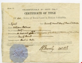
- Scope and Content
- Item consists of "Certificate of Title" to Mr. William Holmes for land in Burnaby/NE Westminster; "40 Acres", "Twenty Second Day of March AD 1860". Description reads: "On West Side at termination of North Road to Port Moody Burrard Inlet". The blue Provincial seal is affixed to the certificate and…
- Repository
- Burnaby Village Museum
- Collection/Fonds
- William Holmes fonds
- Description Level
- Item
- Physical Description
- 1 certificate
- Scope and Content
- Item consists of "Certificate of Title" to Mr. William Holmes for land in Burnaby/NE Westminster; "40 Acres", "Twenty Second Day of March AD 1860". Description reads: "On West Side at termination of North Road to Port Moody Burrard Inlet". The blue Provincial seal is affixed to the certificate and it is signed by R.C. Moody, "Chief Commissioner of Lands and Works".
- Accession Code
- BV997.50.6
- Access Restriction
- No restrictions
- Reproduction Restriction
- No known restrictions
- Date
- 22 Mar. 1860
- Media Type
- Textual Record
- Scan Resolution
- 300
- Scan Date
- 06-May-2019
- Notes
- Title based on contents of item
Images
Certificate of Title
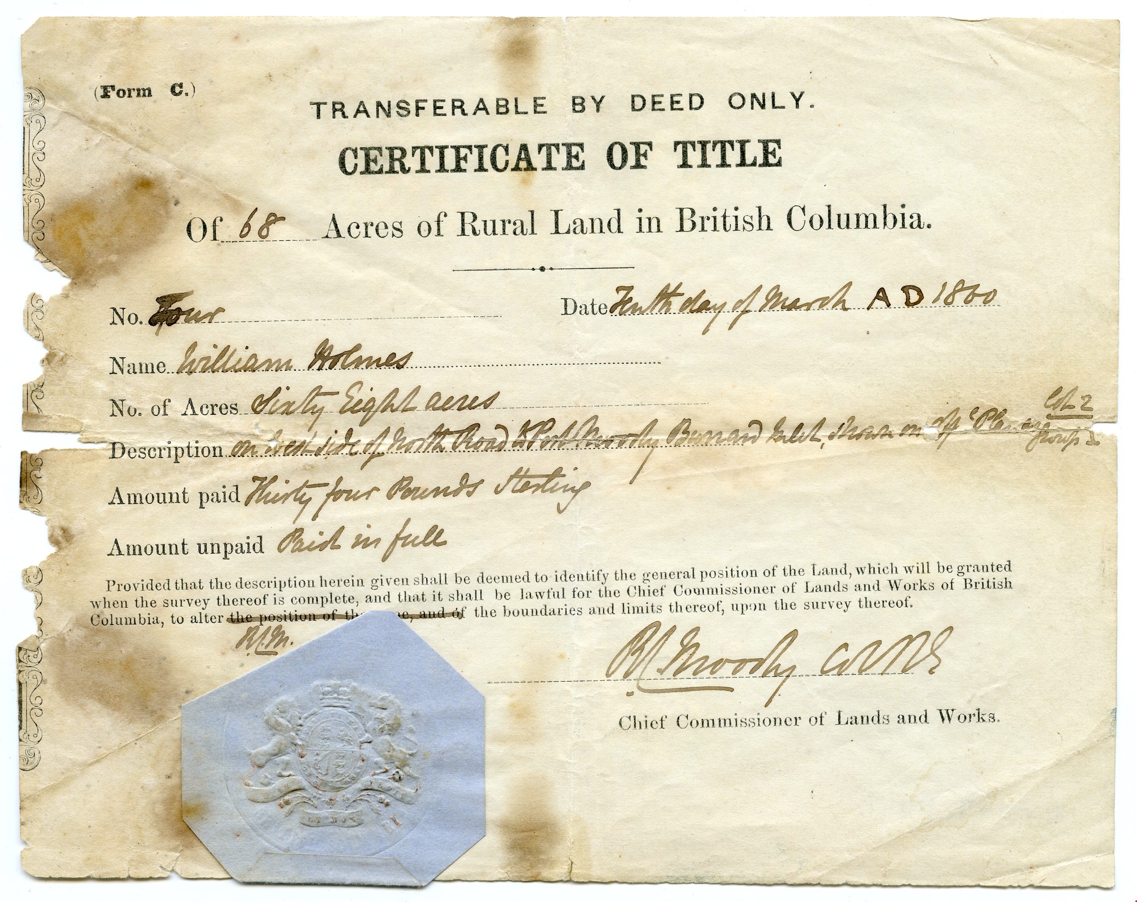
https://search.heritageburnaby.ca/link/museumdescription10409
- Repository
- Burnaby Village Museum
- Date
- 22 Mar. 1860
- Collection/Fonds
- William Holmes fonds
- Description Level
- Item
- Physical Description
- 1 certificate
- Scope and Content
- Item consists of "Certificate of Title" to Mr. William Holmes for land in Burnaby/NE Westminster; "68 Acres", "Tenth Day of March AD 1860". Description reads: "On West Side of North Road to Port Moody Burrard Inlet, shown on the [?] Plan as Lots 2 / Group 1". The blue Provincial seal is affixed to…
- Repository
- Burnaby Village Museum
- Collection/Fonds
- William Holmes fonds
- Description Level
- Item
- Physical Description
- 1 certificate
- Scope and Content
- Item consists of "Certificate of Title" to Mr. William Holmes for land in Burnaby/NE Westminster; "68 Acres", "Tenth Day of March AD 1860". Description reads: "On West Side of North Road to Port Moody Burrard Inlet, shown on the [?] Plan as Lots 2 / Group 1". The blue Provincial seal is affixed to the certificate and it is signed by R.C. Moody "Chief Commissioner of Lands and Works".
- Accession Code
- BV997.50.7
- Access Restriction
- No restrictions
- Reproduction Restriction
- No known restrictions
- Date
- 22 Mar. 1860
- Media Type
- Textual Record
- Scan Resolution
- 300
- Scan Date
- 06-May-2019
- Notes
- Title based on contents of item
Images