Narrow Results By
Subject
- Advertising Medium - Signs and Signboards 1
- Aerial Photographs 1
- Agriculture - Fruit and Berries 1
- Animals 4
- Animals - Cats 2
- Animals - Dogs 3
- Buildings - Commercial - General Stores 1
- Buildings - Commercial - Service Stations 3
- Buildings - Heritage 2
- Buildings - Industrial 1
- Buildings - Industrial - Factories 2
- Buildings - Industrial - Mills 2

Barnet Neighbourhood
https://search.heritageburnaby.ca/link/landmark681
- Repository
- Burnaby Heritage Planning
- Associated Dates
- 1925-1954
- Heritage Value
- In 1925, the mill at Barnet was under new ownership and was known as the Barnet Lumber Company. It was one of the most successful local employers in Burnaby until the 1930s, when the economic crisis of the Great Depression resulted in a strike at the mill. The City of Burnaby eventually assumed control of the site - including all of the homes - when the company failed to pay its taxes. The City then dismantled the mill and resold the property in two parts - the eastern section would become the Kapoor sawmill and the western portion, the McColl-Frontenac Oil Company.
- Historic Neighbourhood
- Barnet (Historic Neighbourhood)
- Planning Study Area
- Burnaby Mountain Area
Images


Barnet Neighbourhood
https://search.heritageburnaby.ca/link/landmark747
- Repository
- Burnaby Heritage Planning
- Associated Dates
- 1905-1924
- Heritage Value
- The original Barnet mill burned down in 1909 after a dramatic explosion in the boiler house. The company rebuilt a new plant, considered a model of mill construction. The company's timber was towed down the Pacific in huge rafts containing about 400,000 to 500,000 board feet. Mill capacity during a 10-hour day was 150,000 board feet with an amazing annual output of 50 million feet.
- Historic Neighbourhood
- Barnet (Historic Neighbourhood)
- Planning Study Area
- Burnaby Mountain Area
Images


Alfred Bingham's writings - Track 3
https://search.heritageburnaby.ca/link/oralhistory253
- Repository
- City of Burnaby Archives
- Date Range
- 1903-1940
- Length
- 0:09:46
- Summary
- This portion of the recording includes Alfred Bingham's descriptions of road construction in Burnaby, including the names of the settlers and logging companies involved in their construction. Alfred discusses the changes that took place during World War I, along with municipal Relief work that he t…
- Repository
- City of Burnaby Archives
- Summary
- This portion of the recording includes Alfred Bingham's descriptions of road construction in Burnaby, including the names of the settlers and logging companies involved in their construction. Alfred discusses the changes that took place during World War I, along with municipal Relief work that he took part in at Burnaby Mountain. Alfred also discusses early schools and mentions his wife, Ada Bingham.
- Date Range
- 1903-1940
- Photo Info
- Alfred Bingham, April 20, 1947. Item no. 010-066
- Length
- 0:09:46
- Planning Study Area
- Burnaby Mountain Area
- Scope and Content
- Recording is of Alfred Bingham's writings, as read by Alfred Bingham. Major themes discussed are: Pioneers, early days in Burnaby and the Co-op Movement. To view "Narrow By" terms for each track expand this description and see "Notes".
- Biographical Notes
- Alfred "Alf" Bingham was born in England in 1892 and moved to Canada in 1912. His first job in Canada was laying track for the Grand Trunk Pacific Railway (GTPR) from Edmonton to McBride in 1912. His second was in Vancouver at the Rat Portage Mill on False Creek, working on the Resaw machine. He quit after one week due to poor working conditions. After taking part in the 1919 Winnipeg General Strike as a delegate of the Retail and Mailorder Union (A.F.L.) on the Winnipeg Trades and Labour Council, Alfred moved to Burnaby where he and fellow Burnaby residents Aungus McLean and Percy Little worked ten hour days to build a Shingle Mill on the edge of Burnaby Lake for Simpson & Giberson. George Green, carpenter and millwright (author of “The History of Burnaby”) also helped in the construction of the mill. Alfred built his own home from lumber cut from the mill in the Lochdale area on Sherlock Street between Curtis Street and Kitchener Street. On April 10, 1920 Alfred married Mary Jane “Ada” Reynolds. Alfred and Ada often took in foster children during their marriage. Due to her nursing experience, Ada was often called upon to deliver babies in the Burnaby area. Alfred and Ada Bingham were instrumental members of the Army of the Common Good, collecting vegetables and grains from growers in the area and even producing over 125 tons of vegetables from its own gardens to feed children and youth suffering from the lack of resources during the Depression years. The army was in operation for ten years and during that time the members organised the Credit Union movement of British Columbia and drew up the Credit Union act thorough the Vancouver Co-operative Council. They also started Co-Op stores and the Co-Op Wholesale Society. Alfred was also Secretary of the Burnaby Housing committee and in 1946 he became the Secretary of the North Burnaby Labour Progressive Party (LPP). Mary Jane “Ada” (Reynolds) Bingham died on August 9, 1969. Her husband Alfred died on April 29, 1979.
- Total Tracks
- 12
- Total Length
- 1:38:06
- Interviewee Name
- Bingham, Alfred "Alf"
- Collection/Fonds
- Burnaby Historical Society fonds
- Subseries
- Oral history subseries
- Transcript Available
- MSS142-001 contains transcripts for each of the short stories
- Media Type
- Sound Recording
- Web Notes
- Interview was digitized in 2010 allowing it to be accessible on Heritage Burnaby. The digitization project was initiated by the Community Heritage Commission with support from City of Burnaby Council and the BC History Digitization Program of the Irving K. Barber Learning Centre, University of British Columbia. It was recognized by the Heritage Society of BC with an award in 2012.
Images

Audio Tracks
Track three of recording of Alfred Bingham's writings
Track three of recording of Alfred Bingham's writings
https://search.heritageburnaby.ca/media/hpo/_Data/_Archives_Oral_Histories/_Unrestricted/100-13-20-2/100-13-20-2_Track_3.mp3Interview with James Haddon, Jean Haddon, Amy Wright and Logan Wright June 27, 1975 - Track 3
https://search.heritageburnaby.ca/link/oralhistory105
- Repository
- City of Burnaby Archives
- Date Range
- 1919-1939
- Length
- 0:09:18
- Summary
- This portion of the interview pertains to Amy Wright's memories of growing up in North Burnaby, as well as Logan Wright and Jim Haddon's memories of Blind Lake (also known as Squint Lake), where the clubhouse now stands at the golf course at Simon Fraser University (SFU).
- Repository
- City of Burnaby Archives
- Summary
- This portion of the interview pertains to Amy Wright's memories of growing up in North Burnaby, as well as Logan Wright and Jim Haddon's memories of Blind Lake (also known as Squint Lake), where the clubhouse now stands at the golf course at Simon Fraser University (SFU).
- Date Range
- 1919-1939
- Length
- 0:09:18
- Planning Study Area
- Burnaby Mountain Area
- Interviewer
- Bradbury, Dr. Bettina
- Interview Date
- June 27, 1975
- Scope and Content
- Recording is of an interview with James "Jim" Haddon, Jean Haddon, Amy Wright and Logan Wright by Simon Fraser University student Bettina Bradbury, June 27, 1975. Major theme discussed is: the Depression. To view "Narrow By" terms for each track expand this description and see "Notes".
- Biographical Notes
- James "Jim", "Jimmy" Haddon was born in 1914 at Royal Columbian Hospital in New Westminster. Jim's father used to hunt in Burnaby as a boy and liked it so much that when he grew up, he built a house at Government Road and Piper Avenue and moved his young family there. Jim's father was a logger and contractor with a team of two horses. Jim began his schooling at Sperling Avenue School in 1921. He attended Sperling for one year, then switched to Seaforth School from 1922 on. Jim's older brother Art hauled gravel for the municipality while Jim was at Seaforth. In 1929, at sixteen years old, Jim left school to work for his father driving the truck, helping to haul logs, wood and gravel. Throughout the 1930s, he did contracting for the municipality. Jim Haddon met his wife Jean when her family moved into the neighbourhood in the 1930s. Jean Haddon was born in Saskatchewan in 1914. Her father's work had gone into receivership and so the family of nine packed up and drove out west in a Dodge Touring car. With two brothers and four sisters, Jean was the oldest. The family settled on Government Road and Phillips Avenue. Jean and her husband Jim Haddon were at a dance together at Cultus Lake when the war broke out. Logan Wright was born in 1915 and moved with his family from Mount Pleasant to Burnaby in 1923 to Phillips Avenue and Greenwood. The Wright family had five acres of land that held one hundred and twenty fruit trees. His father worked for BC Electric in Vancouver, and faced a ten dollar a month cut in pay during the Depression. Logan began at Sperling Avenue School in 1923, then Seaforth School in 1924. He attended Seaforth until 1932 when he left to begin working, first as a farmer, then a gold miner, and a construction worker before securing a job at BC Electric. Amy Wright was born in 1920. Her family lived at the 4300 block of Cambridge Street in the Vancouver Heights neighbourhood of North Burnaby, moving there just a year before she was born. Her father worked at Mac and Mack's in downtown Vancouver five and a half days a week. On the weekends, her family took the Union Steamship to Gibson's. Amy's mother was an active member of the Victorian Order of Nurses (VON). Amy graduated high school in 1938 and went on to University. Logan Wright met his wife Amy in 1946 through Logan's sister Francis, who invited her neighbour Amy to dinner.
- Total Tracks
- 8
- Total Length
- 1:16:28
- Interviewee Name
- Haddon, James "Jimmy"
- Haddon, Jean
- Wright, Amy
- Wright, Logan
- Interview Location
- Gibsons, British Columbia
- Interviewer Bio
- Bettina Bradbury teaches history and women's studies at York University. She is the author of Wife to Widow. Lives, Laws and Politics in Nineteenth-century Montreal. (Vancouver: University of British Columbia Press, June 2011), 520p; Working Families. Age, Gender and Daily Survival in Industrializing Montreal. (Toronto: Canadian Social History Series, McClelland and Stewart, 1993); (Republished Toronto: Oxford University Press, 1996) (3rd edition, Toronto: University of Toronto Press, 2007). These interviews were undertaken after she completed her MA at Simon Fraser University in 1975 with the support of an LIP grant.
- Collection/Fonds
- Burnaby Historical Society fonds
- Subseries
- Oral history subseries
- Media Type
- Sound Recording
- Web Notes
- Interview was digitized in 2010 allowing it to be accessible on Heritage Burnaby. The digitization project was initiated by the Community Heritage Commission with support from City of Burnaby Council and the BC History Digitization Program of the Irving K. Barber Learning Centre, University of British Columbia. It was recognized by the Heritage Society of BC with an award in 2012.
Audio Tracks
Track three of interview with James Haddon, Jean Haddon, Amy Wright and Logan Wright
Track three of interview with James Haddon, Jean Haddon, Amy Wright and Logan Wright
https://search.heritageburnaby.ca/media/hpo/_Data/_Archives_Oral_Histories/_Unrestricted/100-13-15/100-13-15_Track_3.mp3
Alfred Bingham's writings - Track 7
https://search.heritageburnaby.ca/link/oralhistory257
- Repository
- City of Burnaby Archives
- Date Range
- 1919-1939
- Length
- 0:09:44
- Summary
- This portion of the recording includes Alfred Bingham's continuation of reading his series of short stories. He reads "WHAT THE LOCHDALE DISTRICT LOOKED LIKE IN 1919-20-21-22" and "1st and SECOND SETTLERS IN THE LOCHDALE DISTRICT" both written in 1963.
- Repository
- City of Burnaby Archives
- Summary
- This portion of the recording includes Alfred Bingham's continuation of reading his series of short stories. He reads "WHAT THE LOCHDALE DISTRICT LOOKED LIKE IN 1919-20-21-22" and "1st and SECOND SETTLERS IN THE LOCHDALE DISTRICT" both written in 1963.
- Date Range
- 1919-1939
- Photo Info
- Alfred Bingham, April 20, 1947. Item no. 010-066
- Length
- 0:09:44
- Subjects
- Land Clearing
- Historic Neighbourhood
- Lochdale (Historic Neighbourhood)
- Planning Study Area
- Burnaby Mountain Area
- Scope and Content
- Recording is of Alfred Bingham's writings, as read by Alfred Bingham. Major themes discussed are: Pioneers, early days in Burnaby and the Co-op Movement. To view "Narrow By" terms for each track expand this description and see "Notes".
- Biographical Notes
- Alfred "Alf" Bingham was born in England in 1892 and moved to Canada in 1912. His first job in Canada was laying track for the Grand Trunk Pacific Railway (GTPR) from Edmonton to McBride in 1912. His second was in Vancouver at the Rat Portage Mill on False Creek, working on the Resaw machine. He quit after one week due to poor working conditions. After taking part in the 1919 Winnipeg General Strike as a delegate of the Retail and Mailorder Union (A.F.L.) on the Winnipeg Trades and Labour Council, Alfred moved to Burnaby where he and fellow Burnaby residents Aungus McLean and Percy Little worked ten hour days to build a Shingle Mill on the edge of Burnaby Lake for Simpson & Giberson. George Green, carpenter and millwright (author of “The History of Burnaby”) also helped in the construction of the mill. Alfred built his own home from lumber cut from the mill in the Lochdale area on Sherlock Street between Curtis Street and Kitchener Street. On April 10, 1920 Alfred married Mary Jane “Ada” Reynolds. Alfred and Ada often took in foster children during their marriage. Due to her nursing experience, Ada was often called upon to deliver babies in the Burnaby area. Alfred and Ada Bingham were instrumental members of the Army of the Common Good, collecting vegetables and grains from growers in the area and even producing over 125 tons of vegetables from its own gardens to feed children and youth suffering from the lack of resources during the Depression years. The army was in operation for ten years and during that time the members organised the Credit Union movement of British Columbia and drew up the Credit Union act thorough the Vancouver Co-operative Council. They also started Co-Op stores and the Co-Op Wholesale Society. Alfred was also Secretary of the Burnaby Housing committee and in 1946 he became the Secretary of the North Burnaby Labour Progressive Party (LPP). Mary Jane “Ada” (Reynolds) Bingham died on August 9, 1969. Her husband Alfred died on April 29, 1979.
- Total Tracks
- 12
- Total Length
- 1:38:06
- Interviewee Name
- Bingham, Alfred "Alf"
- Collection/Fonds
- Burnaby Historical Society fonds
- Subseries
- Oral history subseries
- Transcript Available
- MSS142-001 contains transcripts for each of the short stories
- Media Type
- Sound Recording
- Web Notes
- Interview was digitized in 2010 allowing it to be accessible on Heritage Burnaby. The digitization project was initiated by the Community Heritage Commission with support from City of Burnaby Council and the BC History Digitization Program of the Irving K. Barber Learning Centre, University of British Columbia. It was recognized by the Heritage Society of BC with an award in 2012.
Images
Audio Tracks
Track seven of recording of Alfred Bingham's writings
Track seven of recording of Alfred Bingham's writings
https://search.heritageburnaby.ca/media/hpo/_Data/_Archives_Oral_Histories/_Unrestricted/100-13-20-2/100-13-20-2_Track_7.mp3![North Pacific Lumber Co. Barnet, B.C., [before 1929] thumbnail](/media/hpo/_Data/_Archives_Images/_Unrestricted/537/539-001.jpg?width=280)
North Pacific Lumber Co. Barnet, B.C.
https://search.heritageburnaby.ca/link/archivedescription72549
- Repository
- City of Burnaby Archives
- Date
- [before 1929]
- Collection/Fonds
- Alan Fish fonds
- Description Level
- Item
- Physical Description
- 1 photograph : sepia postcard ; 8 x 13 cm
- Scope and Content
- Photographic postcard of the North Pacific Lumber Company mill at Barnet Village in Burnaby.
- Repository
- City of Burnaby Archives
- Date
- [before 1929]
- Collection/Fonds
- Alan Fish fonds
- Physical Description
- 1 photograph : sepia postcard ; 8 x 13 cm
- Description Level
- Item
- Record No.
- 539-001
- Access Restriction
- No restrictions
- Reproduction Restriction
- No known restrictions
- Accession Number
- 2007-04
- Scope and Content
- Photographic postcard of the North Pacific Lumber Company mill at Barnet Village in Burnaby.
- Names
- Barnet Mill
- Media Type
- Photograph
- Photographer
- Timms Photographic Co.
- Notes
- Title on recto of photograph in red reads: "438. North Pacific Lumber Co. Barnet, B.C."
- Stamped in red on verso: "Timms Photographic Co., Vancouver, Canada."
- Stamped in black on verso of photograph: "Post Card / Correspondence / Name and Address / Place Postage Stamp Here"
- Note in pen on verso of photograph reads: "Alan Fish / 604 733 0459"
- Geographic Access
- Barnet Village
- Texaco Drive
- Street Address
- 8059 Texaco Drive
- Historic Neighbourhood
- Barnet (Historic Neighbourhood)
- Planning Study Area
- Burnaby Mountain Area
Images
![North Pacific Lumber Co. Barnet, B.C., [before 1929] thumbnail](/media/hpo/_Data/_Archives_Images/_Unrestricted/537/539-001.jpg)
![Pacific Guano Plant, [1920] (date of original), copied 1991 thumbnail](/media/hpo/_Data/_Archives_Images/_Unrestricted/370/370-293.jpg?width=280)
Pacific Guano Plant
https://search.heritageburnaby.ca/link/archivedescription37705
- Repository
- City of Burnaby Archives
- Date
- [1920] (date of original), copied 1991
- Collection/Fonds
- Burnaby Historical Society fonds
- Description Level
- Item
- Physical Description
- 1 photograph : b&w ; 3.1 x 3.9 cm print on contact sheet 20.2 x 25.3 cm
- Scope and Content
- Photograph of the Pacific Guano plant on Burrard Inlet at the foot of Burnaby Mountain. It was also used as chemical plant, processing guano. (Any excrement from birds, seals, or bats, with value to humans as fertilizer, may be referred to as guano).
- Repository
- City of Burnaby Archives
- Date
- [1920] (date of original), copied 1991
- Collection/Fonds
- Burnaby Historical Society fonds
- Subseries
- Burnaby Image Bank subseries
- Physical Description
- 1 photograph : b&w ; 3.1 x 3.9 cm print on contact sheet 20.2 x 25.3 cm
- Description Level
- Item
- Record No.
- 370-293
- Access Restriction
- No restrictions
- Reproduction Restriction
- No known restrictions
- Accession Number
- BHS1999-03
- Scope and Content
- Photograph of the Pacific Guano plant on Burrard Inlet at the foot of Burnaby Mountain. It was also used as chemical plant, processing guano. (Any excrement from birds, seals, or bats, with value to humans as fertilizer, may be referred to as guano).
- Subjects
- Buildings - Industrial
- Names
- Pacific Guano
- Media Type
- Photograph
- Notes
- Title based on contents of photograph
- 1 b&w copy negative accompanying
- Geographic Access
- Barnet Road
- Historic Neighbourhood
- Barnet (Historic Neighbourhood)
- Planning Study Area
- Burnaby Mountain Area
Images
![Pacific Guano Plant, [1920] (date of original), copied 1991 thumbnail](/media/hpo/_Data/_Archives_Images/_Unrestricted/370/370-293.jpg)

Barnet Road
https://search.heritageburnaby.ca/link/archivedescription35635
- Repository
- City of Burnaby Archives
- Date
- 1921 (date of original), copied 1986
- Collection/Fonds
- Burnaby Historical Society fonds
- Description Level
- Item
- Physical Description
- 1 photograph : b&w ; 12.7 x 17.8 cm print
- Scope and Content
- Photograph of Barnet Road covered with November snows. The road was always treacherous in winter with snow and rock slides. In the upper right corner of the photograph is Barnet School and caretaker's cottage. Barnet School was located at 7820 Barnet Road.
- Repository
- City of Burnaby Archives
- Date
- 1921 (date of original), copied 1986
- Collection/Fonds
- Burnaby Historical Society fonds
- Subseries
- Pioneer Tales subseries
- Physical Description
- 1 photograph : b&w ; 12.7 x 17.8 cm print
- Description Level
- Item
- Record No.
- 204-493
- Access Restriction
- No restrictions
- Reproduction Restriction
- No known restrictions
- Accession Number
- BHS1988-03
- Scope and Content
- Photograph of Barnet Road covered with November snows. The road was always treacherous in winter with snow and rock slides. In the upper right corner of the photograph is Barnet School and caretaker's cottage. Barnet School was located at 7820 Barnet Road.
- Names
- Barnet School
- Media Type
- Photograph
- Notes
- Title based on contents of photograph
- Geographic Access
- Barnet Road
- Street Address
- 7820 Barnet Road
- Historic Neighbourhood
- Barnet (Historic Neighbourhood)
- Planning Study Area
- Burnaby Mountain Area
Images


Barnet Road
https://search.heritageburnaby.ca/link/archivedescription35634
- Repository
- City of Burnaby Archives
- Date
- 1922 (date of original), copied 1986
- Collection/Fonds
- Burnaby Historical Society fonds
- Description Level
- Item
- Physical Description
- 1 photograph : b&w ; 12.7 x 17.8 cm print
- Scope and Content
- Photograph of Robert Woolsey carrying his daughter, Margaret, piggy-back along Barnet Road. Note the planked surface. Margaret was two years old at the time. In the upper right corner of the photograph is the Barnet School caretaker's cottage, located beside Barnet School at 7820 Barnet Road.
- Repository
- City of Burnaby Archives
- Date
- 1922 (date of original), copied 1986
- Collection/Fonds
- Burnaby Historical Society fonds
- Subseries
- Pioneer Tales subseries
- Physical Description
- 1 photograph : b&w ; 12.7 x 17.8 cm print
- Description Level
- Item
- Record No.
- 204-492
- Access Restriction
- No restrictions
- Reproduction Restriction
- No known restrictions
- Accession Number
- BHS1988-03
- Scope and Content
- Photograph of Robert Woolsey carrying his daughter, Margaret, piggy-back along Barnet Road. Note the planked surface. Margaret was two years old at the time. In the upper right corner of the photograph is the Barnet School caretaker's cottage, located beside Barnet School at 7820 Barnet Road.
- Subjects
- Geographic Features - Roads
- Media Type
- Photograph
- Notes
- Title based on contents of photograph
- Geographic Access
- Barnet Road
- Street Address
- 7820 Barnet Road
- Historic Neighbourhood
- Barnet (Historic Neighbourhood)
- Planning Study Area
- Burnaby Mountain Area
Images

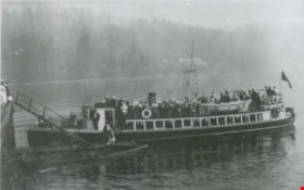
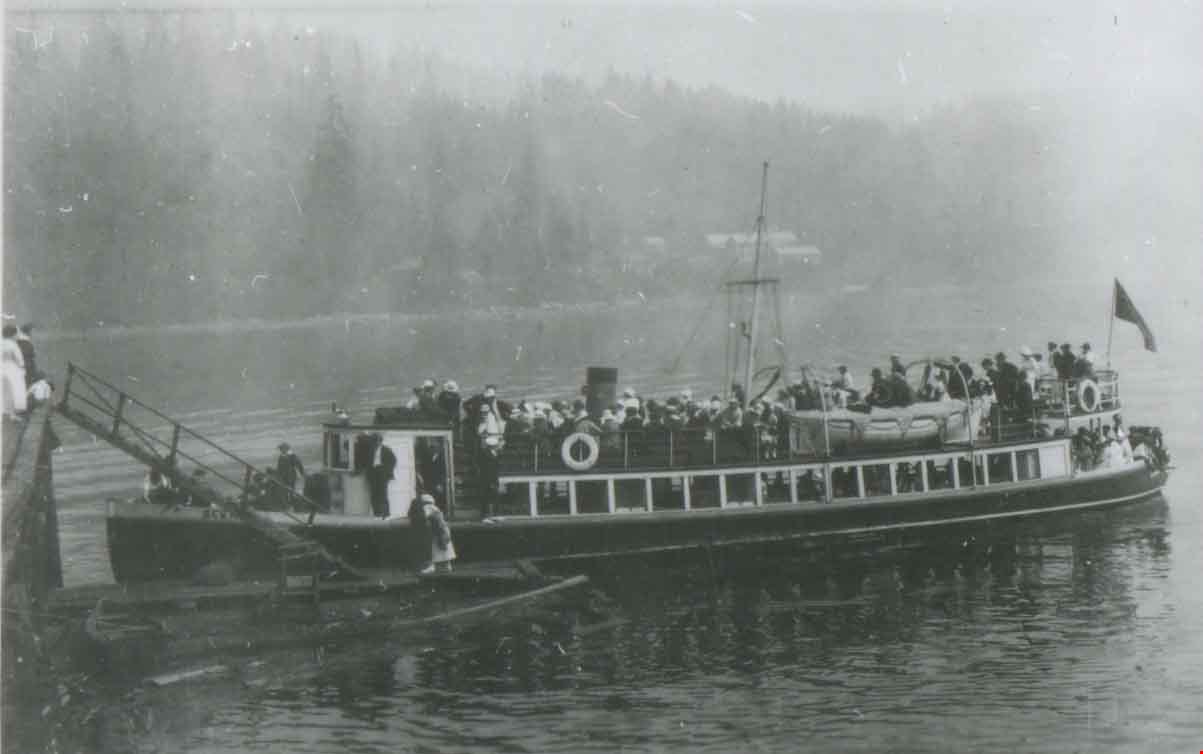
Ferry from Port Moody to Vancouver
https://search.heritageburnaby.ca/link/archivedescription37706
- Repository
- City of Burnaby Archives
- Date
- 1923 (date of original), copied 1991
- Collection/Fonds
- Burnaby Historical Society fonds
- Description Level
- Item
- Physical Description
- 1 photograph : b&w ; 3.3 x 5.1 cm print on contact sheet 20.2 x 25.3 cm
- Scope and Content
- Photograph of the "scenic" ferry from Port Moody to Vancouver through the Burrard Inlet.
- Repository
- City of Burnaby Archives
- Date
- 1923 (date of original), copied 1991
- Collection/Fonds
- Burnaby Historical Society fonds
- Subseries
- Burnaby Image Bank subseries
- Physical Description
- 1 photograph : b&w ; 3.3 x 5.1 cm print on contact sheet 20.2 x 25.3 cm
- Description Level
- Item
- Record No.
- 370-294
- Access Restriction
- No restrictions
- Reproduction Restriction
- No known restrictions
- Accession Number
- BHS1999-03
- Scope and Content
- Photograph of the "scenic" ferry from Port Moody to Vancouver through the Burrard Inlet.
- Media Type
- Photograph
- Notes
- Title based on contents of photograph
- 1 b&w copy negative accompanying
- Historic Neighbourhood
- Barnet (Historic Neighbourhood)
- Planning Study Area
- Burnaby Mountain Area
Images

Kask Camp
https://search.heritageburnaby.ca/link/archivedescription37413
- Repository
- City of Burnaby Archives
- Date
- May 14, 1924 (date of original), copied 1991
- Collection/Fonds
- Burnaby Historical Society fonds
- Description Level
- Item
- Physical Description
- 1 photograph : b&w ; 3.4 x 5.6 cm print on contact sheet 20.2 x 25.4 cm
- Scope and Content
- Photograph of the plot for the first house built at Kask Camp. The electricity lines shown are from Buntzen Power Plant. Barnet Road is seen on the right.
- Repository
- City of Burnaby Archives
- Date
- May 14, 1924 (date of original), copied 1991
- Collection/Fonds
- Burnaby Historical Society fonds
- Subseries
- Burnaby Image Bank subseries
- Physical Description
- 1 photograph : b&w ; 3.4 x 5.6 cm print on contact sheet 20.2 x 25.4 cm
- Description Level
- Item
- Record No.
- 370-001
- Access Restriction
- No restrictions
- Reproduction Restriction
- No known restrictions
- Accession Number
- BHS1999-03
- Scope and Content
- Photograph of the plot for the first house built at Kask Camp. The electricity lines shown are from Buntzen Power Plant. Barnet Road is seen on the right.
- Names
- Kask Camp
- Media Type
- Photograph
- Photographer
- Kask, William Sr.
- Notes
- Title based on contents of photograph
- 1 b&w copy negative accompanying
- Geographic Access
- Barnet Road
- Street Address
- 7501 Barnet Road
- Historic Neighbourhood
- Barnet (Historic Neighbourhood)
- Planning Study Area
- Burnaby Mountain Area
Images

![Jenny and Bill Kask, Jr., at Kask Camp, [1924] (date of original), copied 1991 thumbnail](/media/hpo/_Data/_Archives_Images/_Unrestricted/370/370-010.jpg?width=280)
Jenny and Bill Kask, Jr., at Kask Camp
https://search.heritageburnaby.ca/link/archivedescription37422
- Repository
- City of Burnaby Archives
- Date
- [1924] (date of original), copied 1991
- Collection/Fonds
- Burnaby Historical Society fonds
- Description Level
- Item
- Physical Description
- 1 photograph : b&w ; 3.2 x 5.3 cm print on contact sheet 20.2 x 25.4 cm
- Scope and Content
- Photograph of the front of the first house at Kask Camp. Outside, left to right, are William "Bill" Kask, Jr., and his mother, Jenny Kask.
- Repository
- City of Burnaby Archives
- Date
- [1924] (date of original), copied 1991
- Collection/Fonds
- Burnaby Historical Society fonds
- Subseries
- Burnaby Image Bank subseries
- Physical Description
- 1 photograph : b&w ; 3.2 x 5.3 cm print on contact sheet 20.2 x 25.4 cm
- Description Level
- Item
- Record No.
- 370-010
- Access Restriction
- No restrictions
- Reproduction Restriction
- No known restrictions
- Accession Number
- BHS1999-03
- Scope and Content
- Photograph of the front of the first house at Kask Camp. Outside, left to right, are William "Bill" Kask, Jr., and his mother, Jenny Kask.
- Subjects
- Buildings - Residential - Cabins
- Media Type
- Photograph
- Notes
- Title based on contents of photograph
- 1 b&w copy negative accompanying
- Geographic Access
- Barnet Road
- Street Address
- 7501 Barnet Road
- Historic Neighbourhood
- Barnet (Historic Neighbourhood)
- Planning Study Area
- Burnaby Mountain Area
Images
![Jenny and Bill Kask, Jr., at Kask Camp, [1924] (date of original), copied 1991 thumbnail](/media/hpo/_Data/_Archives_Images/_Unrestricted/370/370-010.jpg)
![Yasue Yasui, [1923] (date of original), copied 2004 thumbnail](/media/hpo/_Data/_BVM_Images/2019/2019_0032_0033_001.jpg?width=280)
Yasue Yasui
https://search.heritageburnaby.ca/link/museumdescription15213
- Repository
- Burnaby Village Museum
- Date
- [1923] (date of original), copied 2004
- Collection/Fonds
- In the Shadow by the Sea collection
- Description Level
- Item
- Physical Description
- 1 photograph (tiff) : 300 dpi
- Scope and Content
- Photograph of young Yasue "Margaret" Yasui (Matsumura) standing on a wooden bridge on the site of the Nichols Chemical Company plant.
- Repository
- Burnaby Village Museum
- Collection/Fonds
- In the Shadow by the Sea collection
- Description Level
- Item
- Physical Description
- 1 photograph (tiff) : 300 dpi
- Scope and Content
- Photograph of young Yasue "Margaret" Yasui (Matsumura) standing on a wooden bridge on the site of the Nichols Chemical Company plant.
- History
- Sukegoro (Shoyen) Yasui (1884-1972) and his wife Tane (Hirata) Yasui (d.1987) emigrated from Japan to Canada in 1919. Sukegoro and Tane had two children Yasue Margaret (Matsumura) (1921-2019) and Harding Yasui (1923-2008). Sukegoro worked as a burner operator for the Nichols Chemical Company of Barnet B.C. The family lived on the site with five other families in a bunkhouse including the three Kokuryo brothers and their families and the Kojima family. The children attended Barnet School for three years before the family moved to Surrey in 1934 after purchasing farm land. Sukegoro and Tane Yasui grew strawberries and raised chickens on the farm and Sukegoro continued to work shift work at the Nichols plant. In 1942, the Yasui family were interned and sent to work on a sugar beet farm near Lethbridge, Alberta. While living in Picture Butte, Alberta,Yasue married Matsuo Matsumura. Following the war, the whole family moved to Kingston, Ontario where Harding completed his senior year of high school. A few years later, Harding moved to Montreal and his parents joined him.
- Geographic Access
- Burrard Inlet
- Accession Code
- BV019.32.33
- Access Restriction
- No restrictions
- Reproduction Restriction
- No known restrictions
- Date
- [1923] (date of original), copied 2004
- Media Type
- Photograph
- Historic Neighbourhood
- Barnet (Historic Neighbourhood)
- Planning Study Area
- Burnaby Mountain Area
- Notes
- Title based on contents of photograph
- See page 127 of book "In the Shadow by the Sea - Recollections of Burnaby's Barnet Village". Caption with photograph reads: "Yasue Yasui, 1926"
- Date of photograph [1924] based on birth dates of Yasue "Margaret"- born 1921 and Harding Yasui- born July 1923
- In the Shadow by the Sea spells Sukegoro's wife's name as "Lane" (Harata) Yasui, obits for Sukegoro Yasui and his wife use the spelling "Tane" Hirata Yasui.
Images
![Yasue Yasui, [1923] (date of original), copied 2004 thumbnail](/media/hpo/_Data/_BVM_Images/2019/2019_0032_0033_001.jpg)
![Yasue and Harding Yasui, [1924] (date of original), copied 2004 thumbnail](/media/hpo/_Data/_BVM_Images/2019/2019_0032_0034_001.jpg?width=280)
Yasue and Harding Yasui
https://search.heritageburnaby.ca/link/museumdescription15216
- Repository
- Burnaby Village Museum
- Date
- [1924] (date of original), copied 2004
- Collection/Fonds
- In the Shadow by the Sea collection
- Description Level
- Item
- Physical Description
- 1 photograph (tiff) : 300 dpi
- Scope and Content
- Photograph of Yasue "Margaret" Yasui (Matsumura) and her brother Harding Yasui on the site of the Nichols Chemical Company plant. Yasue is standing next to her brother who is seated on the grass beside her. A fence is visible behind them.
- Repository
- Burnaby Village Museum
- Collection/Fonds
- In the Shadow by the Sea collection
- Description Level
- Item
- Physical Description
- 1 photograph (tiff) : 300 dpi
- Scope and Content
- Photograph of Yasue "Margaret" Yasui (Matsumura) and her brother Harding Yasui on the site of the Nichols Chemical Company plant. Yasue is standing next to her brother who is seated on the grass beside her. A fence is visible behind them.
- History
- Sukegoro (Shoyen) Yasui (1884-1972) and his wife Tane (Hirata) Yasui (d.1987) emigrated from Japan to Canada in 1919. Sukegoro and Tane had two children Yasue Margaret (Matsumura) (1921-2019) and Harding Yasui (1923-2008). Sukegoro worked as a burner operator for the Nichols Chemical Company of Barnet B.C. The family lived on the site with five other families in a bunkhouse including the three Kokuryo brothers and their families and the Kojima family. The children attended Barnet School for three years before the family moved to Surrey in 1934 after purchasing farm land. Sukegoro and Tane Yasui grew strawberries and raised chickens on the farm and Sukegoro continued to work shift work at the Nichols plant. In 1942, the Yasui family were interned and sent to work on a sugar beet farm near Lethbridge, Alberta. While living in Picture Butte, Alberta,Yasue married Matsuo Matsumura. Following the war, the whole family moved to Kingston, Ontario where Harding completed his senior year of high school. A few years later, Harding moved to Montreal and his parents joined him.
- Geographic Access
- Burrard Inlet
- Accession Code
- BV019.32.34
- Access Restriction
- No restrictions
- Reproduction Restriction
- No known restrictions
- Date
- [1924] (date of original), copied 2004
- Media Type
- Photograph
- Historic Neighbourhood
- Barnet (Historic Neighbourhood)
- Planning Study Area
- Burnaby Mountain Area
- Notes
- Title based on contents of photograph
- See page 127 of book "In the Shadow by the Sea - Recollections of Burnaby's Barnet Village". Caption with photograph reads: "Yasueand Harding Yasui, 1923"
- Date of photograph [1924] based on birth dates of Yasue "Margaret"- born 1921 and Harding Yasui- born July 1923
- In the Shadow by the Sea spells Sukegoro's wife's name as "Lane" (Harata) Yasui, obits for Sukegoro Yasui and his wife use the spelling "Tane" Hirata Yasui
Images
![Yasue and Harding Yasui, [1924] (date of original), copied 2004 thumbnail](/media/hpo/_Data/_BVM_Images/2019/2019_0032_0034_001.jpg)

Barnet Lumber Company House
https://search.heritageburnaby.ca/link/landmark662
- Repository
- Burnaby Heritage Planning
- Description
- Residential building.
- Associated Dates
- 1925
- Street View URL
- Google Maps Street View
- Repository
- Burnaby Heritage Planning
- Geographic Access
- Texaco Drive
- Associated Dates
- 1925
- Description
- Residential building.
- Heritage Value
- This house is one of two surviving houses built as a “Model Home” for the manager of the Barnet Lumber Company, which was the successor to the North Pacific Lumber Company. It was used as a combined home and office. It was constructed with framing lumber and millwork sawn at the mill. Typical of the Craftsman style, the house has a front gabled roof with triangular eave brackets. It has been altered with the addition of asbestos shingles over the original siding, but retains its form, scale and massing. This house was designed by the firm of Townley & Matheson. The partnership of Fred Laughton Townley (1887-1966) and Robert Michael Matheson began in 1919, and the firm left a rich legacy of sophisticated work, including schools, commercial structures, many fine residences and the landmark Vancouver City Hall.
- Historic Neighbourhood
- Barnet (Historic Neighbourhood)
- Planning Study Area
- Burnaby Mountain Area
- Architect
- Townley & Matheson
- Area
- 2225.77
- Contributing Resource
- Building
- Ownership
- Public (local)
- Street Address
- 8007 Texaco Drive
- Street View URL
- Google Maps Street View
Images


Barnet Lumber Company House
https://search.heritageburnaby.ca/link/landmark663
- Repository
- Burnaby Heritage Planning
- Description
- Residential building.
- Associated Dates
- 1925
- Street View URL
- Google Maps Street View
- Repository
- Burnaby Heritage Planning
- Geographic Access
- Texaco Drive
- Associated Dates
- 1925
- Description
- Residential building.
- Heritage Value
- This house is one of two surviving houses built as a “Model Home” for one of the assistant managers of the Barnet Lumber Company, using framing lumber and millwork sawn at the mill. This house was also designed by the firm of Townley & Matheson. The house was raised and renovated in 1997, resulting in alterations such as new dormers and elongated porch piers.
- Historic Neighbourhood
- Barnet (Historic Neighbourhood)
- Planning Study Area
- Burnaby Mountain Area
- Architect
- Townley & Matheson
- Contributing Resource
- Building
- Ownership
- Private
- Street Address
- 8039 Texaco Drive
- Street View URL
- Google Maps Street View
Images

In the Shadow by the Sea collection
https://search.heritageburnaby.ca/link/museumdescription15208
- Repository
- Burnaby Village Museum
- Date
- [1925-1953] (date of originals)
- Collection/Fonds
- In the Shadow by the Sea collection
- Description Level
- Fonds
- Physical Description
- 115 photographs (tiffs)
- Scope and Content
- Collection consists of copies of photographs from a selection of Burnaby residents that were obtained for the publication "In the Shadow by the Sea: Recollections of Burnaby's Barnet Village". Photographs include; Kapoor Sawmills Limited and the Siddoo family; the Irwin family; the Lauder family; t…
- Repository
- Burnaby Village Museum
- Collection/Fonds
- In the Shadow by the Sea collection
- Description Level
- Fonds
- Physical Description
- 115 photographs (tiffs)
- Scope and Content
- Collection consists of copies of photographs from a selection of Burnaby residents that were obtained for the publication "In the Shadow by the Sea: Recollections of Burnaby's Barnet Village". Photographs include; Kapoor Sawmills Limited and the Siddoo family; the Irwin family; the Lauder family; the Yasui family and the Laleune family. The selection of photographs document time living and working in the Barnet area of Burnaby.
- History
- The book, "In the Shadow by the Sea: Recollections of Burnaby's Barnet Village" was published in 2004 as a historical project under the direction of the Community Heritage Commission. Community Heritage Commission volunteer Harry Pride was the driving force behind this project contacting many former residents of Barnet to obtain photographs and stories for the book. The book documents the history of the settlement of Burnaby's Barnet district including memoirs and photographs of various people who worked and lived there.
- Accession Code
- BV019.32
- Date
- [1925-1953] (date of originals)
- Media Type
- Photograph
- Historic Neighbourhood
- Barnet (Historic Neighbourhood)
- Planning Study Area
- Burnaby Mountain Area
- Related Material
- See also, City of Burnaby Archives: Burnaby Historical Society fonds - "In the Shadow by the Sea subseries"
- Notes
- Title based on contents of collection
![Barnet Lumber mill, [192-] (date of original), copied 2004 thumbnail](/media/hpo/_Data/_BVM_Images/2019/2019_0032_0051_001.jpg?width=280)
Barnet Lumber mill
https://search.heritageburnaby.ca/link/museumdescription15232
- Repository
- Burnaby Village Museum
- Date
- [192-] (date of original), copied 2004
- Collection/Fonds
- In the Shadow by the Sea collection
- Description Level
- Item
- Physical Description
- 1 photograph (tiff) : 300 dpi
- Scope and Content
- Photograph of the Barnet Lumber Company mill in operation. C.P.R. railroad tracks are visible in the foreground and trees on the north shore of Burrard Inlet are visible in the distance. Plumes of smoke are rising from the mill chimneys.
- Repository
- Burnaby Village Museum
- Collection/Fonds
- In the Shadow by the Sea collection
- Description Level
- Item
- Physical Description
- 1 photograph (tiff) : 300 dpi
- Scope and Content
- Photograph of the Barnet Lumber Company mill in operation. C.P.R. railroad tracks are visible in the foreground and trees on the north shore of Burrard Inlet are visible in the distance. Plumes of smoke are rising from the mill chimneys.
- History
- The Barnet Lumber Company also known as the Barnet mill was in operation between 1925 and 1932. The mill was located on Burrard Inlet in the neighbourhood of Barnet and was one of the most successful local employers in Burnaby until the 1930s when the Great Depression resulted in a strike at the mill. The City of Burnaby eventually assumed control of the site including all of the homes when the company failed to pay it's taxes. The city then dismantled the mill and sold the property in two parts - the eastern section would become the Kapoor Sawmills Limited and the western portion, the McColl-Frontenac Oil Company.
- Names
- Barnet Lumber Company
- Geographic Access
- Burrard Inlet
- Accession Code
- BV019.32.51
- Access Restriction
- No restrictions
- Reproduction Restriction
- No known restrictions
- Date
- [192-] (date of original), copied 2004
- Media Type
- Photograph
- Historic Neighbourhood
- Barnet (Historic Neighbourhood)
- Planning Study Area
- Burnaby Mountain Area
- Notes
- Title based on contents of photograph
Images
![Barnet Lumber mill, [192-] (date of original), copied 2004 thumbnail](/media/hpo/_Data/_BVM_Images/2019/2019_0032_0051_001.jpg)
![Japanese sailing ship in Burrard Inlet, [1925] (date of original), copied 2004 thumbnail](/media/hpo/_Data/_BVM_Images/2019/2019_0032_0054_001.jpg?width=280)
Japanese sailing ship in Burrard Inlet
https://search.heritageburnaby.ca/link/museumdescription15235
- Repository
- Burnaby Village Museum
- Date
- [1925] (date of original), copied 2004
- Collection/Fonds
- In the Shadow by the Sea collection
- Description Level
- Item
- Physical Description
- 1 photograph (tiff) : 300 dpi
- Scope and Content
- Photograph of two children standing at a gate of a picket fence and looking towards buildings and a four masted Japanese sailing ship docked next to the Barnet Mill in Burrard Inlet. Residences and buildings from Barnet are visible in the distance.
- Repository
- Burnaby Village Museum
- Collection/Fonds
- In the Shadow by the Sea collection
- Description Level
- Item
- Physical Description
- 1 photograph (tiff) : 300 dpi
- Scope and Content
- Photograph of two children standing at a gate of a picket fence and looking towards buildings and a four masted Japanese sailing ship docked next to the Barnet Mill in Burrard Inlet. Residences and buildings from Barnet are visible in the distance.
- History
- The Barnet Lumber Company also known as the Barnet mill was in operation between 1925 and 1932. The mill was located on Burrard Inlet in the neighbourhood of Barnet and was one of the most successful local employers in Burnaby until the 1930s when the Great Depression resulted in a strike at the mill. The City of Burnaby eventually assumed control of the site including all of the homes when the company failed to pay it's taxes. The city then dismantled the mill and sold the property in two parts - the eastern section would become the Kapoor Sawmills Limited and the western portion, the McColl-Frontenac Oil Company.
- Subjects
- Transportation - Ships
- Geographic Access
- Burrard Inlet
- Accession Code
- BV019.32.54
- Access Restriction
- No restrictions
- Reproduction Restriction
- No known restrictions
- Date
- [1925] (date of original), copied 2004
- Media Type
- Photograph
- Historic Neighbourhood
- Barnet (Historic Neighbourhood)
- Planning Study Area
- Burnaby Mountain Area
- Notes
- Title based on contents of photograph
- See also photograph detail BV019.32.53
Images
![Japanese sailing ship in Burrard Inlet, [1925] (date of original), copied 2004 thumbnail](/media/hpo/_Data/_BVM_Images/2019/2019_0032_0054_001.jpg)
![Japanese sailing ship in Burrard Inlet, [1925] (date of original), copied 2004 thumbnail](/media/hpo/_Data/_BVM_Images/2019/2019_0032_0056_001.jpg?width=280)
Japanese sailing ship in Burrard Inlet
https://search.heritageburnaby.ca/link/museumdescription15237
- Repository
- Burnaby Village Museum
- Date
- [1925] (date of original), copied 2004
- Collection/Fonds
- In the Shadow by the Sea collection
- Description Level
- Item
- Physical Description
- 1 photograph (tiff) : 300 dpi
- Scope and Content
- Photograph detail of two children standing at a gate of a picket fence and looking towards buildings and a four masted Japanese sailing ship docked next to the Barnet Mill in Burrard Inlet. Residences and buildings from Barnet are visible in the distance.
- Repository
- Burnaby Village Museum
- Collection/Fonds
- In the Shadow by the Sea collection
- Description Level
- Item
- Physical Description
- 1 photograph (tiff) : 300 dpi
- Scope and Content
- Photograph detail of two children standing at a gate of a picket fence and looking towards buildings and a four masted Japanese sailing ship docked next to the Barnet Mill in Burrard Inlet. Residences and buildings from Barnet are visible in the distance.
- History
- The Barnet Lumber Company also known as the Barnet mill was in operation between 1925 and 1932. The mill was located on Burrard Inlet in the neighbourhood of Barnet and was one of the most successful local employers in Burnaby until the 1930s when the Great Depression resulted in a strike at the mill. The City of Burnaby eventually assumed control of the site including all of the homes when the company failed to pay it's taxes. The city then dismantled the mill and sold the property in two parts - the eastern section would become the Kapoor Sawmills Limited and the western portion, the McColl-Frontenac Oil Company.
- Subjects
- Transportation - Ships
- Geographic Access
- Burrard Inlet
- Accession Code
- BV019.32.56
- Access Restriction
- No restrictions
- Reproduction Restriction
- No known restrictions
- Date
- [1925] (date of original), copied 2004
- Media Type
- Photograph
- Historic Neighbourhood
- Barnet (Historic Neighbourhood)
- Planning Study Area
- Burnaby Mountain Area
- Notes
- Title based on contents of photograph
- Image is cropped from original photograph BV019.32.54
Images
![Japanese sailing ship in Burrard Inlet, [1925] (date of original), copied 2004 thumbnail](/media/hpo/_Data/_BVM_Images/2019/2019_0032_0056_001.jpg)