Narrow Results By
Person / Organization
- Avendaño, Adrian 1
- Bateman, Marianne May 1
- Boal, Ethel May Jackson 4
- Boal, Glen 6
- Boal, Thomas "Tom" 2
- Boal, William Ewart 4
- British Columbia Electric Railway Company 8
- British Columbia Hydro and Power Authority 1
- Brownlee, James Harrison 1
- Burnaby Central Secondary School 20
- Burnaby Fire Department 1
- Burnaby Lake Nature House 4
6741 Cariboo Rd Burnaby
https://search.heritageburnaby.ca/link/archivedescription94308
- Repository
- City of Burnaby Archives
- Date
- April 1994
- Collection/Fonds
- Grover, Elliott & Co. Ltd. fonds
- Description Level
- File
- Physical Description
- 25 photographs : col. negatives ; 35 mm
- Scope and Content
- Photographs of an undeveloped property, single-storey industrial building, and railroad crossing.
- Repository
- City of Burnaby Archives
- Date
- April 1994
- Collection/Fonds
- Grover, Elliott & Co. Ltd. fonds
- Physical Description
- 25 photographs : col. negatives ; 35 mm
- Description Level
- File
- Record No.
- 622-093
- Access Restriction
- No restrictions
- Reproduction Restriction
- No restrictions
- Accession Number
- 2017-39
- Scope and Content
- Photographs of an undeveloped property, single-storey industrial building, and railroad crossing.
- Media Type
- Photograph
- Photographer
- Young, Richard
- Notes
- Transcribed title
- Title transcribed from envelope photographs were originally housed in
- File no. 94-115-B
- Geographic Access
- Cariboo Road
- Street Address
- 6741 Cariboo Road
- Planning Study Area
- Burnaby Lake Area
Aerial photograph of Burnaby
https://search.heritageburnaby.ca/link/archivedescription84907
- Repository
- City of Burnaby Archives
- Date
- 1963
- Collection/Fonds
- Allan Amundsen collection
- Description Level
- Item
- Physical Description
- 1 photograph : b&w ; 22.5 x 22.5 cm
- Scope and Content
- Aerial photograph of Burnaby with the Trans Canada Highway running from through and Burnaby Lake in the south east corner.
- Repository
- City of Burnaby Archives
- Date
- 1963
- Collection/Fonds
- Allan Amundsen collection
- Physical Description
- 1 photograph : b&w ; 22.5 x 22.5 cm
- Description Level
- Item
- Record No.
- 561-025
- Access Restriction
- In Archives only
- Reproduction Restriction
- No reproduction permitted
- Accession Number
- 2014-08
- Scope and Content
- Aerial photograph of Burnaby with the Trans Canada Highway running from through and Burnaby Lake in the south east corner.
- Subjects
- Aerial Photographs
- Media Type
- Photograph
- Photographer
- Province of British Columbia
- Notes
- Title based on contents of photograph
- This photo is indentified as BC5062:26 and connects with B.C. air photograph BC5062:27 to the west and B.C. air photograph BC5062:25 to the east
- Historic Neighbourhood
- Burnaby Lake (Historic Neighbourhood)
- Planning Study Area
- Douglas-Gilpin Area
- Ardingley-Sprott Area
- Burnaby Lake Area
Aerial photograph of Burnaby
https://search.heritageburnaby.ca/link/archivedescription84911
- Repository
- City of Burnaby Archives
- Date
- 1963
- Collection/Fonds
- Allan Amundsen collection
- Description Level
- Item
- Physical Description
- 1 photograph : b&w ; 22.5 x 22.5 cm
- Scope and Content
- Aerial photograph of Burnaby with Lougheed Highway running west to east through the middle of the photograph and the Trans Canada Highway in the lower left segment.
- Repository
- City of Burnaby Archives
- Date
- 1963
- Collection/Fonds
- Allan Amundsen collection
- Physical Description
- 1 photograph : b&w ; 22.5 x 22.5 cm
- Description Level
- Item
- Record No.
- 561-029
- Access Restriction
- In Archives only
- Reproduction Restriction
- No reproduction permitted
- Accession Number
- 2014-08
- Scope and Content
- Aerial photograph of Burnaby with Lougheed Highway running west to east through the middle of the photograph and the Trans Canada Highway in the lower left segment.
- Subjects
- Aerial Photographs
- Media Type
- Photograph
- Photographer
- Province of British Columbia
- Notes
- Title based on contents of photograph
- This photo is indentified as BC5062:22 and connects with B.C. air photograph BC5062:23 to the west and B.C. air photograph BC5062:21
- Historic Neighbourhood
- Lozells (Historic Neighbourhood)
- Burquitlam (Historic Neighbourhood)
- Planning Study Area
- Lake City Area
- Government Road Area
- Burnaby Lake Area
- Lyndhurst Area
- Cariboo-Armstrong Area
Aerial photograph of Burnaby Lake Area
https://search.heritageburnaby.ca/link/archivedescription84908
- Repository
- City of Burnaby Archives
- Date
- 1963
- Collection/Fonds
- Allan Amundsen collection
- Description Level
- Item
- Physical Description
- 1 photograph : b&w ; 22.5 x 22.5 cm
- Scope and Content
- Aerial photograph of Burnaby with Lougheed Highway in the north west corner, the Trans Canada Highway in the south east corner and Burnaby Lake appearing from the west.
- Repository
- City of Burnaby Archives
- Date
- 1963
- Collection/Fonds
- Allan Amundsen collection
- Physical Description
- 1 photograph : b&w ; 22.5 x 22.5 cm
- Description Level
- Item
- Record No.
- 561-026
- Access Restriction
- In Archives only
- Reproduction Restriction
- No reproduction permitted
- Accession Number
- 2014-08
- Scope and Content
- Aerial photograph of Burnaby with Lougheed Highway in the north west corner, the Trans Canada Highway in the south east corner and Burnaby Lake appearing from the west.
- Subjects
- Aerial Photographs
- Media Type
- Photograph
- Photographer
- Province of British Columbia
- Notes
- Title based on contents of photograph
- This photo is indentified as BC5062:25 and connects with B.C. air photograph BC5062:26 to the west and B.C. air photograph BC5062:24 to the east
- Historic Neighbourhood
- Burnaby Lake (Historic Neighbourhood)
- Lozells (Historic Neighbourhood)
- Planning Study Area
- Douglas-Gilpin Area
- Sperling-Broadway Area
- Government Road Area
- Burnaby Lake Area
Aerial photograph of Burnaby Lake Area
https://search.heritageburnaby.ca/link/archivedescription84909
- Repository
- City of Burnaby Archives
- Date
- 1963
- Collection/Fonds
- Allan Amundsen collection
- Description Level
- Item
- Physical Description
- 1 photograph : b&w ; 22.5 x 22.5 cm
- Scope and Content
- Aerial photograph of Burnaby with Lougheed Highway to the north and Burnaby Lake to the south.
- Repository
- City of Burnaby Archives
- Date
- 1963
- Collection/Fonds
- Allan Amundsen collection
- Physical Description
- 1 photograph : b&w ; 22.5 x 22.5 cm
- Description Level
- Item
- Record No.
- 561-027
- Access Restriction
- In Archives only
- Reproduction Restriction
- No reproduction permitted
- Accession Number
- 2014-08
- Scope and Content
- Aerial photograph of Burnaby with Lougheed Highway to the north and Burnaby Lake to the south.
- Subjects
- Aerial Photographs
- Media Type
- Photograph
- Photographer
- Province of British Columbia
- Notes
- Title based on contents of photograph
- This photo is indentified as BC5062:24 and connects with B.C. air photograph BC5062:25 to the west and B.C. air photograph BC5062:23 to the east
- Historic Neighbourhood
- Burnaby Lake (Historic Neighbourhood)
- Lozells (Historic Neighbourhood)
- Planning Study Area
- Douglas-Gilpin Area
- Sperling-Broadway Area
- Government Road Area
- Burnaby Lake Area
Aerial photograph of Burnaby Lake Area
https://search.heritageburnaby.ca/link/archivedescription84910
- Repository
- City of Burnaby Archives
- Date
- 1963
- Collection/Fonds
- Allan Amundsen collection
- Description Level
- Item
- Physical Description
- 1 photograph : b&w ; 22.5 x 22.5 cm
- Scope and Content
- Aerial photograph of Burnaby with Burnaby Lake to the south and Broadway to the north.
- Repository
- City of Burnaby Archives
- Date
- 1963
- Collection/Fonds
- Allan Amundsen collection
- Physical Description
- 1 photograph : b&w ; 22.5 x 22.5 cm
- Description Level
- Item
- Record No.
- 561-028
- Access Restriction
- In Archives only
- Reproduction Restriction
- No reproduction permitted
- Accession Number
- 2014-08
- Scope and Content
- Aerial photograph of Burnaby with Burnaby Lake to the south and Broadway to the north.
- Subjects
- Aerial Photographs
- Media Type
- Photograph
- Photographer
- Province of British Columbia
- Notes
- Title based on contents of photograph
- This photo is indentified as BC5062:23 and connects with B.C. air photograph BC5062:24 to the west and B.C. air photograph BC5062:22 to the east
- Historic Neighbourhood
- Burnaby Lake (Historic Neighbourhood)
- Lozells (Historic Neighbourhood)
- Planning Study Area
- Lake City Area
- Government Road Area
- Burnaby Lake Area
![Aerial view of Burnaby Lake, October 20, 1961 (date of original), copied [1985] thumbnail](/media/hpo/_Data/_BVM_Images/1985/1985_0457_0002_001.jpg?width=280)
Aerial view of Burnaby Lake
https://search.heritageburnaby.ca/link/museumdescription10583
- Repository
- Burnaby Village Museum
- Date
- October 20, 1961 (date of original), copied [1985]
- Collection/Fonds
- Burnaby Village Museum Photograph collection
- Description Level
- Item
- Physical Description
- 1 photograph : b&w copy negative ; 10 x 12 cm
- Scope and Content
- Photograph of aerial view of Burnaby Lake and construction for water main crossing at Piper Avenue.
- Repository
- Burnaby Village Museum
- Collection/Fonds
- Burnaby Village Museum Photograph collection
- Description Level
- Item
- Physical Description
- 1 photograph : b&w copy negative ; 10 x 12 cm
- Scope and Content
- Photograph of aerial view of Burnaby Lake and construction for water main crossing at Piper Avenue.
- Accession Code
- BV985.457.2
- Access Restriction
- No restrictions
- Reproduction Restriction
- May be restricted by third party rights
- Date
- October 20, 1961 (date of original), copied [1985]
- Media Type
- Photograph
- Historic Neighbourhood
- Burnaby Lake (Historic Neighbourhood)
- Planning Study Area
- Burnaby Lake Area
- Scan Resolution
- 1200
- Scan Date
- 2022-06-07
- Photographer
- George Allen Aerial Photos Limited
- Notes
- Title based on contents of photograph
Images
![Aerial view of Burnaby Lake, October 20, 1961 (date of original), copied [1985] thumbnail](/media/hpo/_Data/_BVM_Images/1985/1985_0457_0002_001.jpg)
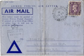
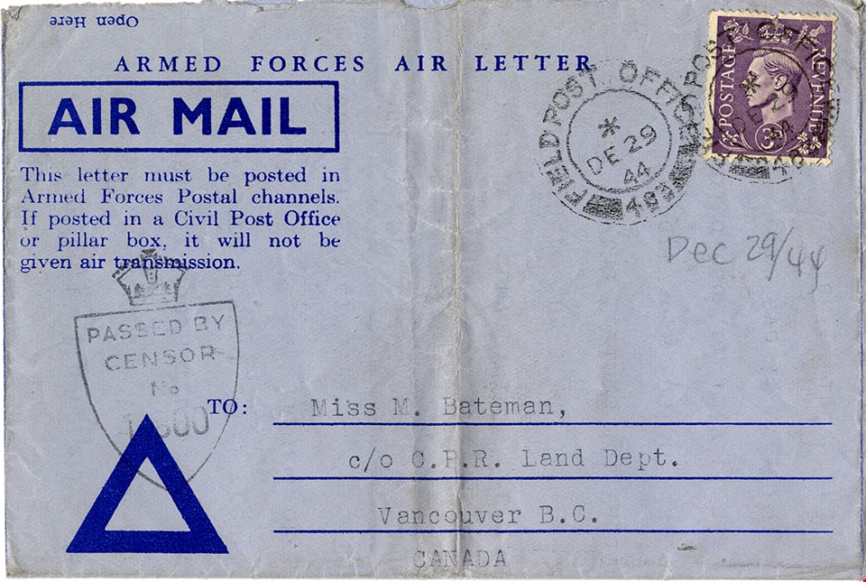
Air mail letter from Colin Fox to May Bateman
https://search.heritageburnaby.ca/link/museumdescription15145
- Repository
- Burnaby Village Museum
- Date
- 27 Dec. 1944
- Collection/Fonds
- E.W. Bateman family fonds
- Description Level
- Item
- Physical Description
- 1 p. (double sided and folded)
- Scope and Content
- Item consists of a typewritten air mail letter from Sergeant Colin Rhodes Fox of the Royal Canadian Artillery Service to his aunt Marianne "May" Bateman while serving overseas during World War II. Colin Fox served in the 13th Canadian Field Regiment with the 44th and 78th Canadian Field Battery. In…
- Repository
- Burnaby Village Museum
- Collection/Fonds
- E.W. Bateman family fonds
- Description Level
- Item
- Physical Description
- 1 p. (double sided and folded)
- Scope and Content
- Item consists of a typewritten air mail letter from Sergeant Colin Rhodes Fox of the Royal Canadian Artillery Service to his aunt Marianne "May" Bateman while serving overseas during World War II. Colin Fox served in the 13th Canadian Field Regiment with the 44th and 78th Canadian Field Battery. In his letter Colin reflects on how he spent Christmas day and how he discovered that the camp cook came from the Burnaby Lake area.
- Accession Code
- BV020.27.32
- Access Restriction
- Restricted access
- Reproduction Restriction
- May be restricted by third party rights
- Date
- 27 Dec. 1944
- Media Type
- Textual Record
- Scan Resolution
- 600
- Scan Date
- 10-Feb-2021
- Scale
- 100
- Notes
- Title based on contents of item
- Air mail letter is addressed to: "Miss M. Bateman / c/o C.P.R. Land Dept. / Vancouver B.C. / Canada"
- Circular postmark stamps read: "FIELD POST OFFICE 403 / 8 / DE 29 / 44"
- Stamp on outside of air mail letter reads: "PASSED BY / CENSOR / No. / 11800"
- Return address on outside of air mail letter reads: "K19022 Sgt. / C.R.Fox"
Images
![The Albert Memorial, [1880] thumbnail](/media/hpo/_Data/_Archives_Images/_Unrestricted/477/477-770.jpg?width=280)
The Albert Memorial
https://search.heritageburnaby.ca/link/archivedescription39451
- Repository
- City of Burnaby Archives
- Date
- [1880]
- Collection/Fonds
- Peers Family and Hill Family fonds
- Description Level
- Item
- Physical Description
- 1 photograph : b&w ; 10.7 x 17.5 cm on page 21.5 x 28 cm (pasted in album)
- Scope and Content
- Photograph of the Albert Memorial. This item was in a scrapbook kept by Claude Hill who was originally from England but ultimately settled in the Burnaby Lake area.
- Repository
- City of Burnaby Archives
- Date
- [1880]
- Collection/Fonds
- Peers Family and Hill Family fonds
- Physical Description
- 1 photograph : b&w ; 10.7 x 17.5 cm on page 21.5 x 28 cm (pasted in album)
- Description Level
- Item
- Record No.
- 477-770
- Access Restriction
- No restrictions
- Reproduction Restriction
- No known restrictions
- Accession Number
- 2007-12
- Scope and Content
- Photograph of the Albert Memorial. This item was in a scrapbook kept by Claude Hill who was originally from England but ultimately settled in the Burnaby Lake area.
- Subjects
- Arts - Sculptures
- Media Type
- Photograph
- Notes
- Title based on caption accompanying photograph
Images
![The Albert Memorial, [1880] thumbnail](/media/hpo/_Data/_Archives_Images/_Unrestricted/477/477-770.jpg)
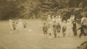
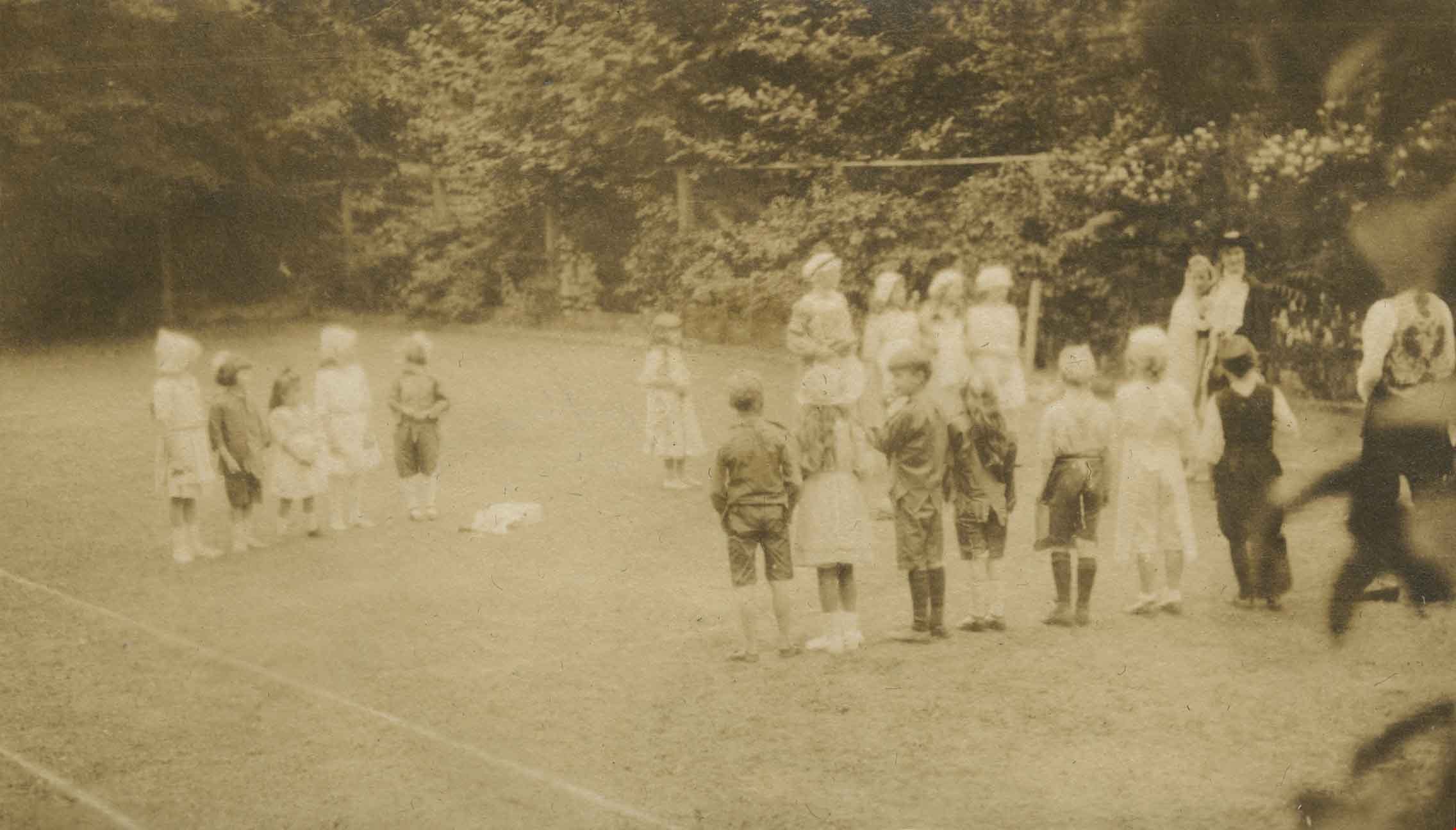
Alice in Wonderland party
https://search.heritageburnaby.ca/link/archivedescription38887
- Repository
- City of Burnaby Archives
- Date
- 1912
- Collection/Fonds
- Peers Family and Hill Family fonds
- Description Level
- Item
- Physical Description
- 1 photograph : sepia ; 5.5 x 9.7 cm on page 14 x 17.5 cm (pasted in album)
- Scope and Content
- Photograph of children enjoying an Alice in Wonderland party held as part of the St. Alban's Strawberry Social, 1912. The children are playing a game on the lawn at the Hart House, the estate belonging to Frederick J. Hart in the Burnaby Lake area.
- Repository
- City of Burnaby Archives
- Date
- 1912
- Collection/Fonds
- Peers Family and Hill Family fonds
- Physical Description
- 1 photograph : sepia ; 5.5 x 9.7 cm on page 14 x 17.5 cm (pasted in album)
- Description Level
- Item
- Record No.
- 477-206
- Access Restriction
- No restrictions
- Reproduction Restriction
- No known restrictions
- Accession Number
- 2007-12
- Scope and Content
- Photograph of children enjoying an Alice in Wonderland party held as part of the St. Alban's Strawberry Social, 1912. The children are playing a game on the lawn at the Hart House, the estate belonging to Frederick J. Hart in the Burnaby Lake area.
- Subjects
- Clothing - Costumes
- Events - Parties
- Media Type
- Photograph
- Notes
- Title based on caption accompanying photograph
- Geographic Access
- Deer Lake Avenue
- Street Address
- 6664 Deer Lake Avenue
- Historic Neighbourhood
- Burnaby Lake (Historic Neighbourhood)
- Planning Study Area
- Morley-Buckingham Area
Images
Allocation of Land in the Burnaby Lake Area Between the Greater Vancouver Regional District and the Municipality
https://search.heritageburnaby.ca/link/councilreport29716
- Repository
- City of Burnaby Archives
- Report ID
- 22150
- Meeting Date
- 20-Mar-1972
- Format
- Council - Committee Report
- Collection/Fonds
- City Council and Office of the City Clerk fonds
- Repository
- City of Burnaby Archives
- Report ID
- 22150
- Meeting Date
- 20-Mar-1972
- Format
- Council - Committee Report
- Collection/Fonds
- City Council and Office of the City Clerk fonds
Documents
![Along an unidentified river, [1880] thumbnail](/media/hpo/_Data/_Archives_Images/_Unrestricted/477/477-807.jpg?width=280)
Along an unidentified river
https://search.heritageburnaby.ca/link/archivedescription39488
- Repository
- City of Burnaby Archives
- Date
- [1880]
- Collection/Fonds
- Peers Family and Hill Family fonds
- Description Level
- Item
- Physical Description
- 1 photograph : sepia ; 9.5 x 15.7 cm on page 21.5 x 28 cm (pasted in album)
- Scope and Content
- Photograph taken along an unidentified river. This photograph was in a scrapbook kept by Claude Hill who was originally from England but ultimately settled in the Burnaby Lake area.
- Repository
- City of Burnaby Archives
- Date
- [1880]
- Collection/Fonds
- Peers Family and Hill Family fonds
- Physical Description
- 1 photograph : sepia ; 9.5 x 15.7 cm on page 21.5 x 28 cm (pasted in album)
- Description Level
- Item
- Record No.
- 477-807
- Access Restriction
- No restrictions
- Reproduction Restriction
- No known restrictions
- Accession Number
- 2007-12
- Scope and Content
- Photograph taken along an unidentified river. This photograph was in a scrapbook kept by Claude Hill who was originally from England but ultimately settled in the Burnaby Lake area.
- Subjects
- Geographic Features - Rivers
- Media Type
- Photograph
- Notes
- Title based on contents of photograph
Images
![Along an unidentified river, [1880] thumbnail](/media/hpo/_Data/_Archives_Images/_Unrestricted/477/477-807.jpg)
![Along the French Coast, [1880] thumbnail](/media/hpo/_Data/_Archives_Images/_Unrestricted/477/477-772.jpg?width=280)
Along the French Coast
https://search.heritageburnaby.ca/link/archivedescription39453
- Repository
- City of Burnaby Archives
- Date
- [1880]
- Collection/Fonds
- Peers Family and Hill Family fonds
- Description Level
- Item
- Physical Description
- 1 photograph : b&w ; 9.6 x 15.5 cm on page 21.5 x 28 cm (pasted in album)
- Scope and Content
- This photograph was in a scrapbook kept by Claude Hill who was originally from England but ultimately settled in the Burnaby Lake area.
- Repository
- City of Burnaby Archives
- Date
- [1880]
- Collection/Fonds
- Peers Family and Hill Family fonds
- Physical Description
- 1 photograph : b&w ; 9.6 x 15.5 cm on page 21.5 x 28 cm (pasted in album)
- Description Level
- Item
- Record No.
- 477-772
- Access Restriction
- No restrictions
- Reproduction Restriction
- No known restrictions
- Accession Number
- 2007-12
- Scope and Content
- This photograph was in a scrapbook kept by Claude Hill who was originally from England but ultimately settled in the Burnaby Lake area.
- Subjects
- Buildings
- Media Type
- Photograph
- Notes
- Title based on contents of photograph
Images
![Along the French Coast, [1880] thumbnail](/media/hpo/_Data/_Archives_Images/_Unrestricted/477/477-772.jpg)
![Antwerp, Belgium, [1880] thumbnail](/media/hpo/_Data/_Archives_Images/_Unrestricted/477/477-811.jpg?width=280)
Antwerp, Belgium
https://search.heritageburnaby.ca/link/archivedescription39492
- Repository
- City of Burnaby Archives
- Date
- [1880]
- Collection/Fonds
- Peers Family and Hill Family fonds
- Description Level
- Item
- Physical Description
- 1 photograph : sepia ; 11 x 17.7 cm on page 21.5 x 28 cm (pasted in album)
- Scope and Content
- Photograph of Antwerp, Belgium. This item was in a scrapbook kept by Claude Hill who was originally from England but ultimately settled in the Burnaby Lake area.
- Repository
- City of Burnaby Archives
- Date
- [1880]
- Collection/Fonds
- Peers Family and Hill Family fonds
- Physical Description
- 1 photograph : sepia ; 11 x 17.7 cm on page 21.5 x 28 cm (pasted in album)
- Description Level
- Item
- Record No.
- 477-811
- Access Restriction
- No restrictions
- Reproduction Restriction
- No known restrictions
- Accession Number
- 2007-12
- Scope and Content
- Photograph of Antwerp, Belgium. This item was in a scrapbook kept by Claude Hill who was originally from England but ultimately settled in the Burnaby Lake area.
- Subjects
- Buildings
- Media Type
- Photograph
- Notes
- Title based on contents of photograph
Images
![Antwerp, Belgium, [1880] thumbnail](/media/hpo/_Data/_Archives_Images/_Unrestricted/477/477-811.jpg)
Application for Renewal of Permit to Use Lots 40 and 39 in the Burnaby Lake Area for Garden Purposes
https://search.heritageburnaby.ca/link/councilreport56709
- Repository
- City of Burnaby Archives
- Report ID
- 72436
- Meeting Date
- 1-Feb-1933
- Format
- Council - Mayor/Councillor/Staff Report
- Collection/Fonds
- City Council and Office of the City Clerk fonds
- Repository
- City of Burnaby Archives
- Report ID
- 72436
- Meeting Date
- 1-Feb-1933
- Format
- Council - Mayor/Councillor/Staff Report
- Collection/Fonds
- City Council and Office of the City Clerk fonds
Documents
Applications for Half Acre Block Use in Burnaby Lake Area
https://search.heritageburnaby.ca/link/councilreport62941
- Repository
- City of Burnaby Archives
- Report ID
- 55379
- Meeting Date
- 4-Apr-1932
- Format
- Council - Mayor/Councillor/Staff Report
- Collection/Fonds
- City Council and Office of the City Clerk fonds
- Repository
- City of Burnaby Archives
- Report ID
- 55379
- Meeting Date
- 4-Apr-1932
- Format
- Council - Mayor/Councillor/Staff Report
- Collection/Fonds
- City Council and Office of the City Clerk fonds
Documents
![Arc de Triomphe, [1880] thumbnail](/media/hpo/_Data/_Archives_Images/_Unrestricted/477/477-790.jpg?width=280)
Arc de Triomphe
https://search.heritageburnaby.ca/link/archivedescription39471
- Repository
- City of Burnaby Archives
- Date
- [1880]
- Collection/Fonds
- Peers Family and Hill Family fonds
- Description Level
- Item
- Physical Description
- 1 photograph : b&w ; 10.3 x 14.4 cm on page 21.5 x 28 cm (pasted in album)
- Scope and Content
- Photorgaph of the Arc de Triomphe. This item was in a scrapbook kept by Claude Hill who was originally from England but ultimately settled in the Burnaby Lake area.
- Repository
- City of Burnaby Archives
- Date
- [1880]
- Collection/Fonds
- Peers Family and Hill Family fonds
- Physical Description
- 1 photograph : b&w ; 10.3 x 14.4 cm on page 21.5 x 28 cm (pasted in album)
- Description Level
- Item
- Record No.
- 477-790
- Access Restriction
- No restrictions
- Reproduction Restriction
- No known restrictions
- Accession Number
- 2007-12
- Scope and Content
- Photorgaph of the Arc de Triomphe. This item was in a scrapbook kept by Claude Hill who was originally from England but ultimately settled in the Burnaby Lake area.
- Subjects
- Structures - Arches
- Media Type
- Photograph
- Notes
- Title based on contents of photograph
Images
![Arc de Triomphe, [1880] thumbnail](/media/hpo/_Data/_Archives_Images/_Unrestricted/477/477-790.jpg)
![Audrey Pontifex at Burnaby Lake, [between 1945 and 1949] (date of original), copied 1991 thumbnail](/media/hpo/_Data/_Archives_Images/_Unrestricted/370/370-504.jpg?width=280)
Audrey Pontifex at Burnaby Lake
https://search.heritageburnaby.ca/link/archivedescription37916
- Repository
- City of Burnaby Archives
- Date
- [between 1945 and 1949] (date of original), copied 1991
- Collection/Fonds
- Burnaby Historical Society fonds
- Description Level
- Item
- Physical Description
- 1 photograph : b&w ; 3.9 x 2.7 cm print on contact sheet 20.7 x 26.5 cm
- Scope and Content
- Photograph of Audrey Pontifex standing beside the water at Burnaby Lake.
- Repository
- City of Burnaby Archives
- Date
- [between 1945 and 1949] (date of original), copied 1991
- Collection/Fonds
- Burnaby Historical Society fonds
- Subseries
- Burnaby Image Bank subseries
- Physical Description
- 1 photograph : b&w ; 3.9 x 2.7 cm print on contact sheet 20.7 x 26.5 cm
- Description Level
- Item
- Record No.
- 370-504
- Access Restriction
- No restrictions
- Reproduction Restriction
- No restrictions
- Accession Number
- BHS1999-03
- Scope and Content
- Photograph of Audrey Pontifex standing beside the water at Burnaby Lake.
- Media Type
- Photograph
- Notes
- Title based on contents of photograph
- 1 b&w copy negative accompanying
- Negative has a pink cast
- Geographic Access
- Burnaby Lake
- Historic Neighbourhood
- Burnaby Lake (Historic Neighbourhood)
- Planning Study Area
- Burnaby Lake Area
Images
![Audrey Pontifex at Burnaby Lake, [between 1945 and 1949] (date of original), copied 1991 thumbnail](/media/hpo/_Data/_Archives_Images/_Unrestricted/370/370-504.jpg)
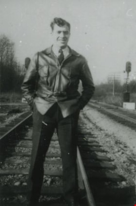
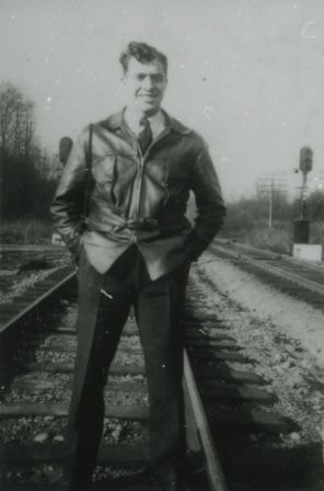
Basil Pontifex
https://search.heritageburnaby.ca/link/archivedescription37903
- Repository
- City of Burnaby Archives
- Date
- January 1948 (date of original), copied 1991
- Collection/Fonds
- Burnaby Historical Society fonds
- Description Level
- Item
- Physical Description
- 1 photograph : b&w ; 3.5 x 2.3 cm print on contact sheet 20.2 x 26.3 cm
- Scope and Content
- Photograph of Basil Pontifex at the Great Northern Railway tracks located around the Burnaby Lake area.
- Repository
- City of Burnaby Archives
- Date
- January 1948 (date of original), copied 1991
- Collection/Fonds
- Burnaby Historical Society fonds
- Subseries
- Burnaby Image Bank subseries
- Physical Description
- 1 photograph : b&w ; 3.5 x 2.3 cm print on contact sheet 20.2 x 26.3 cm
- Description Level
- Item
- Record No.
- 370-491
- Access Restriction
- No restrictions
- Reproduction Restriction
- No known restrictions
- Accession Number
- BHS1999-03
- Scope and Content
- Photograph of Basil Pontifex at the Great Northern Railway tracks located around the Burnaby Lake area.
- Subjects
- Transportation - Rail
- Media Type
- Photograph
- Notes
- Title based on contents of photograph
- 1 b&w copy negative accompanying
- Negative has a pink cast
Images

BCER Burnaby Lake Line
https://search.heritageburnaby.ca/link/landmark760
- Repository
- Burnaby Heritage Planning
- Associated Dates
- 1911
- Heritage Value
- The Burnaby Lake Line was constructed due to the advocacy of Burnaby residents and the Municipality of Burnaby to build the line. A petition was circulated by residents in 1907, and eventually substantial land bonuses were given to the company to induce them to build the line. Property owners in the area hoped the construction of the line would increase their land values. Construction of the 15-mile line was announced in 1909, and the line opened in 1911. The line travelled from Vancouver to New Westminister through central Burnaby.The last day of service was October 23, 1953. When the Trans Canada highway was constructed in the 1960s, it followed the right of way of the Burnaby Lake Line through Burnaby.
- Historic Neighbourhood
- Burnaby Lake (Historic Neighbourhood)
- Planning Study Area
- Burnaby Lake Area
Images
