6741 Cariboo Rd Burnaby
https://search.heritageburnaby.ca/link/archivedescription94308
- Repository
- City of Burnaby Archives
- Date
- April 1994
- Collection/Fonds
- Grover, Elliott & Co. Ltd. fonds
- Description Level
- File
- Physical Description
- 25 photographs : col. negatives ; 35 mm
- Scope and Content
- Photographs of an undeveloped property, single-storey industrial building, and railroad crossing.
- Repository
- City of Burnaby Archives
- Date
- April 1994
- Collection/Fonds
- Grover, Elliott & Co. Ltd. fonds
- Physical Description
- 25 photographs : col. negatives ; 35 mm
- Description Level
- File
- Record No.
- 622-093
- Access Restriction
- No restrictions
- Reproduction Restriction
- No restrictions
- Accession Number
- 2017-39
- Scope and Content
- Photographs of an undeveloped property, single-storey industrial building, and railroad crossing.
- Media Type
- Photograph
- Photographer
- Young, Richard
- Notes
- Transcribed title
- Title transcribed from envelope photographs were originally housed in
- File no. 94-115-B
- Geographic Access
- Cariboo Road
- Street Address
- 6741 Cariboo Road
- Planning Study Area
- Burnaby Lake Area
Aerial photograph of Burnaby
https://search.heritageburnaby.ca/link/archivedescription84907
- Repository
- City of Burnaby Archives
- Date
- 1963
- Collection/Fonds
- Allan Amundsen collection
- Description Level
- Item
- Physical Description
- 1 photograph : b&w ; 22.5 x 22.5 cm
- Scope and Content
- Aerial photograph of Burnaby with the Trans Canada Highway running from through and Burnaby Lake in the south east corner.
- Repository
- City of Burnaby Archives
- Date
- 1963
- Collection/Fonds
- Allan Amundsen collection
- Physical Description
- 1 photograph : b&w ; 22.5 x 22.5 cm
- Description Level
- Item
- Record No.
- 561-025
- Access Restriction
- In Archives only
- Reproduction Restriction
- No reproduction permitted
- Accession Number
- 2014-08
- Scope and Content
- Aerial photograph of Burnaby with the Trans Canada Highway running from through and Burnaby Lake in the south east corner.
- Subjects
- Aerial Photographs
- Media Type
- Photograph
- Photographer
- Province of British Columbia
- Notes
- Title based on contents of photograph
- This photo is indentified as BC5062:26 and connects with B.C. air photograph BC5062:27 to the west and B.C. air photograph BC5062:25 to the east
- Historic Neighbourhood
- Burnaby Lake (Historic Neighbourhood)
- Planning Study Area
- Douglas-Gilpin Area
- Ardingley-Sprott Area
- Burnaby Lake Area
Aerial photograph of Burnaby
https://search.heritageburnaby.ca/link/archivedescription84911
- Repository
- City of Burnaby Archives
- Date
- 1963
- Collection/Fonds
- Allan Amundsen collection
- Description Level
- Item
- Physical Description
- 1 photograph : b&w ; 22.5 x 22.5 cm
- Scope and Content
- Aerial photograph of Burnaby with Lougheed Highway running west to east through the middle of the photograph and the Trans Canada Highway in the lower left segment.
- Repository
- City of Burnaby Archives
- Date
- 1963
- Collection/Fonds
- Allan Amundsen collection
- Physical Description
- 1 photograph : b&w ; 22.5 x 22.5 cm
- Description Level
- Item
- Record No.
- 561-029
- Access Restriction
- In Archives only
- Reproduction Restriction
- No reproduction permitted
- Accession Number
- 2014-08
- Scope and Content
- Aerial photograph of Burnaby with Lougheed Highway running west to east through the middle of the photograph and the Trans Canada Highway in the lower left segment.
- Subjects
- Aerial Photographs
- Media Type
- Photograph
- Photographer
- Province of British Columbia
- Notes
- Title based on contents of photograph
- This photo is indentified as BC5062:22 and connects with B.C. air photograph BC5062:23 to the west and B.C. air photograph BC5062:21
- Historic Neighbourhood
- Lozells (Historic Neighbourhood)
- Burquitlam (Historic Neighbourhood)
- Planning Study Area
- Lake City Area
- Government Road Area
- Burnaby Lake Area
- Lyndhurst Area
- Cariboo-Armstrong Area
Aerial photograph of Burnaby Lake Area
https://search.heritageburnaby.ca/link/archivedescription84908
- Repository
- City of Burnaby Archives
- Date
- 1963
- Collection/Fonds
- Allan Amundsen collection
- Description Level
- Item
- Physical Description
- 1 photograph : b&w ; 22.5 x 22.5 cm
- Scope and Content
- Aerial photograph of Burnaby with Lougheed Highway in the north west corner, the Trans Canada Highway in the south east corner and Burnaby Lake appearing from the west.
- Repository
- City of Burnaby Archives
- Date
- 1963
- Collection/Fonds
- Allan Amundsen collection
- Physical Description
- 1 photograph : b&w ; 22.5 x 22.5 cm
- Description Level
- Item
- Record No.
- 561-026
- Access Restriction
- In Archives only
- Reproduction Restriction
- No reproduction permitted
- Accession Number
- 2014-08
- Scope and Content
- Aerial photograph of Burnaby with Lougheed Highway in the north west corner, the Trans Canada Highway in the south east corner and Burnaby Lake appearing from the west.
- Subjects
- Aerial Photographs
- Media Type
- Photograph
- Photographer
- Province of British Columbia
- Notes
- Title based on contents of photograph
- This photo is indentified as BC5062:25 and connects with B.C. air photograph BC5062:26 to the west and B.C. air photograph BC5062:24 to the east
- Historic Neighbourhood
- Burnaby Lake (Historic Neighbourhood)
- Lozells (Historic Neighbourhood)
- Planning Study Area
- Douglas-Gilpin Area
- Sperling-Broadway Area
- Government Road Area
- Burnaby Lake Area
Aerial photograph of Burnaby Lake Area
https://search.heritageburnaby.ca/link/archivedescription84909
- Repository
- City of Burnaby Archives
- Date
- 1963
- Collection/Fonds
- Allan Amundsen collection
- Description Level
- Item
- Physical Description
- 1 photograph : b&w ; 22.5 x 22.5 cm
- Scope and Content
- Aerial photograph of Burnaby with Lougheed Highway to the north and Burnaby Lake to the south.
- Repository
- City of Burnaby Archives
- Date
- 1963
- Collection/Fonds
- Allan Amundsen collection
- Physical Description
- 1 photograph : b&w ; 22.5 x 22.5 cm
- Description Level
- Item
- Record No.
- 561-027
- Access Restriction
- In Archives only
- Reproduction Restriction
- No reproduction permitted
- Accession Number
- 2014-08
- Scope and Content
- Aerial photograph of Burnaby with Lougheed Highway to the north and Burnaby Lake to the south.
- Subjects
- Aerial Photographs
- Media Type
- Photograph
- Photographer
- Province of British Columbia
- Notes
- Title based on contents of photograph
- This photo is indentified as BC5062:24 and connects with B.C. air photograph BC5062:25 to the west and B.C. air photograph BC5062:23 to the east
- Historic Neighbourhood
- Burnaby Lake (Historic Neighbourhood)
- Lozells (Historic Neighbourhood)
- Planning Study Area
- Douglas-Gilpin Area
- Sperling-Broadway Area
- Government Road Area
- Burnaby Lake Area
Aerial photograph of Burnaby Lake Area
https://search.heritageburnaby.ca/link/archivedescription84910
- Repository
- City of Burnaby Archives
- Date
- 1963
- Collection/Fonds
- Allan Amundsen collection
- Description Level
- Item
- Physical Description
- 1 photograph : b&w ; 22.5 x 22.5 cm
- Scope and Content
- Aerial photograph of Burnaby with Burnaby Lake to the south and Broadway to the north.
- Repository
- City of Burnaby Archives
- Date
- 1963
- Collection/Fonds
- Allan Amundsen collection
- Physical Description
- 1 photograph : b&w ; 22.5 x 22.5 cm
- Description Level
- Item
- Record No.
- 561-028
- Access Restriction
- In Archives only
- Reproduction Restriction
- No reproduction permitted
- Accession Number
- 2014-08
- Scope and Content
- Aerial photograph of Burnaby with Burnaby Lake to the south and Broadway to the north.
- Subjects
- Aerial Photographs
- Media Type
- Photograph
- Photographer
- Province of British Columbia
- Notes
- Title based on contents of photograph
- This photo is indentified as BC5062:23 and connects with B.C. air photograph BC5062:24 to the west and B.C. air photograph BC5062:22 to the east
- Historic Neighbourhood
- Burnaby Lake (Historic Neighbourhood)
- Lozells (Historic Neighbourhood)
- Planning Study Area
- Lake City Area
- Government Road Area
- Burnaby Lake Area
![Aerial view of Burnaby Lake, October 20, 1961 (date of original), copied [1985] thumbnail](/media/hpo/_Data/_BVM_Images/1985/1985_0457_0002_001.jpg?width=280)
Aerial view of Burnaby Lake
https://search.heritageburnaby.ca/link/museumdescription10583
- Repository
- Burnaby Village Museum
- Date
- October 20, 1961 (date of original), copied [1985]
- Collection/Fonds
- Burnaby Village Museum Photograph collection
- Description Level
- Item
- Physical Description
- 1 photograph : b&w copy negative ; 10 x 12 cm
- Scope and Content
- Photograph of aerial view of Burnaby Lake and construction for water main crossing at Piper Avenue.
- Repository
- Burnaby Village Museum
- Collection/Fonds
- Burnaby Village Museum Photograph collection
- Description Level
- Item
- Physical Description
- 1 photograph : b&w copy negative ; 10 x 12 cm
- Scope and Content
- Photograph of aerial view of Burnaby Lake and construction for water main crossing at Piper Avenue.
- Accession Code
- BV985.457.2
- Access Restriction
- No restrictions
- Reproduction Restriction
- May be restricted by third party rights
- Date
- October 20, 1961 (date of original), copied [1985]
- Media Type
- Photograph
- Historic Neighbourhood
- Burnaby Lake (Historic Neighbourhood)
- Planning Study Area
- Burnaby Lake Area
- Scan Resolution
- 1200
- Scan Date
- 2022-06-07
- Photographer
- George Allen Aerial Photos Limited
- Notes
- Title based on contents of photograph
Images
![Aerial view of Burnaby Lake, October 20, 1961 (date of original), copied [1985] thumbnail](/media/hpo/_Data/_BVM_Images/1985/1985_0457_0002_001.jpg)
![The Albert Memorial, [1880] thumbnail](/media/hpo/_Data/_Archives_Images/_Unrestricted/477/477-770.jpg?width=280)
The Albert Memorial
https://search.heritageburnaby.ca/link/archivedescription39451
- Repository
- City of Burnaby Archives
- Date
- [1880]
- Collection/Fonds
- Peers Family and Hill Family fonds
- Description Level
- Item
- Physical Description
- 1 photograph : b&w ; 10.7 x 17.5 cm on page 21.5 x 28 cm (pasted in album)
- Scope and Content
- Photograph of the Albert Memorial. This item was in a scrapbook kept by Claude Hill who was originally from England but ultimately settled in the Burnaby Lake area.
- Repository
- City of Burnaby Archives
- Date
- [1880]
- Collection/Fonds
- Peers Family and Hill Family fonds
- Physical Description
- 1 photograph : b&w ; 10.7 x 17.5 cm on page 21.5 x 28 cm (pasted in album)
- Description Level
- Item
- Record No.
- 477-770
- Access Restriction
- No restrictions
- Reproduction Restriction
- No known restrictions
- Accession Number
- 2007-12
- Scope and Content
- Photograph of the Albert Memorial. This item was in a scrapbook kept by Claude Hill who was originally from England but ultimately settled in the Burnaby Lake area.
- Subjects
- Arts - Sculptures
- Media Type
- Photograph
- Notes
- Title based on caption accompanying photograph
Images
![The Albert Memorial, [1880] thumbnail](/media/hpo/_Data/_Archives_Images/_Unrestricted/477/477-770.jpg)
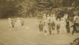
Alice in Wonderland party
https://search.heritageburnaby.ca/link/archivedescription38887
- Repository
- City of Burnaby Archives
- Date
- 1912
- Collection/Fonds
- Peers Family and Hill Family fonds
- Description Level
- Item
- Physical Description
- 1 photograph : sepia ; 5.5 x 9.7 cm on page 14 x 17.5 cm (pasted in album)
- Scope and Content
- Photograph of children enjoying an Alice in Wonderland party held as part of the St. Alban's Strawberry Social, 1912. The children are playing a game on the lawn at the Hart House, the estate belonging to Frederick J. Hart in the Burnaby Lake area.
- Repository
- City of Burnaby Archives
- Date
- 1912
- Collection/Fonds
- Peers Family and Hill Family fonds
- Physical Description
- 1 photograph : sepia ; 5.5 x 9.7 cm on page 14 x 17.5 cm (pasted in album)
- Description Level
- Item
- Record No.
- 477-206
- Access Restriction
- No restrictions
- Reproduction Restriction
- No known restrictions
- Accession Number
- 2007-12
- Scope and Content
- Photograph of children enjoying an Alice in Wonderland party held as part of the St. Alban's Strawberry Social, 1912. The children are playing a game on the lawn at the Hart House, the estate belonging to Frederick J. Hart in the Burnaby Lake area.
- Subjects
- Clothing - Costumes
- Events - Parties
- Media Type
- Photograph
- Notes
- Title based on caption accompanying photograph
- Geographic Access
- Deer Lake Avenue
- Street Address
- 6664 Deer Lake Avenue
- Historic Neighbourhood
- Burnaby Lake (Historic Neighbourhood)
- Planning Study Area
- Morley-Buckingham Area
Images
![Along an unidentified river, [1880] thumbnail](/media/hpo/_Data/_Archives_Images/_Unrestricted/477/477-807.jpg?width=280)
Along an unidentified river
https://search.heritageburnaby.ca/link/archivedescription39488
- Repository
- City of Burnaby Archives
- Date
- [1880]
- Collection/Fonds
- Peers Family and Hill Family fonds
- Description Level
- Item
- Physical Description
- 1 photograph : sepia ; 9.5 x 15.7 cm on page 21.5 x 28 cm (pasted in album)
- Scope and Content
- Photograph taken along an unidentified river. This photograph was in a scrapbook kept by Claude Hill who was originally from England but ultimately settled in the Burnaby Lake area.
- Repository
- City of Burnaby Archives
- Date
- [1880]
- Collection/Fonds
- Peers Family and Hill Family fonds
- Physical Description
- 1 photograph : sepia ; 9.5 x 15.7 cm on page 21.5 x 28 cm (pasted in album)
- Description Level
- Item
- Record No.
- 477-807
- Access Restriction
- No restrictions
- Reproduction Restriction
- No known restrictions
- Accession Number
- 2007-12
- Scope and Content
- Photograph taken along an unidentified river. This photograph was in a scrapbook kept by Claude Hill who was originally from England but ultimately settled in the Burnaby Lake area.
- Subjects
- Geographic Features - Rivers
- Media Type
- Photograph
- Notes
- Title based on contents of photograph
Images
![Along an unidentified river, [1880] thumbnail](/media/hpo/_Data/_Archives_Images/_Unrestricted/477/477-807.jpg)
![Along the French Coast, [1880] thumbnail](/media/hpo/_Data/_Archives_Images/_Unrestricted/477/477-772.jpg?width=280)
Along the French Coast
https://search.heritageburnaby.ca/link/archivedescription39453
- Repository
- City of Burnaby Archives
- Date
- [1880]
- Collection/Fonds
- Peers Family and Hill Family fonds
- Description Level
- Item
- Physical Description
- 1 photograph : b&w ; 9.6 x 15.5 cm on page 21.5 x 28 cm (pasted in album)
- Scope and Content
- This photograph was in a scrapbook kept by Claude Hill who was originally from England but ultimately settled in the Burnaby Lake area.
- Repository
- City of Burnaby Archives
- Date
- [1880]
- Collection/Fonds
- Peers Family and Hill Family fonds
- Physical Description
- 1 photograph : b&w ; 9.6 x 15.5 cm on page 21.5 x 28 cm (pasted in album)
- Description Level
- Item
- Record No.
- 477-772
- Access Restriction
- No restrictions
- Reproduction Restriction
- No known restrictions
- Accession Number
- 2007-12
- Scope and Content
- This photograph was in a scrapbook kept by Claude Hill who was originally from England but ultimately settled in the Burnaby Lake area.
- Subjects
- Buildings
- Media Type
- Photograph
- Notes
- Title based on contents of photograph
Images
![Along the French Coast, [1880] thumbnail](/media/hpo/_Data/_Archives_Images/_Unrestricted/477/477-772.jpg)
![Antwerp, Belgium, [1880] thumbnail](/media/hpo/_Data/_Archives_Images/_Unrestricted/477/477-811.jpg?width=280)
Antwerp, Belgium
https://search.heritageburnaby.ca/link/archivedescription39492
- Repository
- City of Burnaby Archives
- Date
- [1880]
- Collection/Fonds
- Peers Family and Hill Family fonds
- Description Level
- Item
- Physical Description
- 1 photograph : sepia ; 11 x 17.7 cm on page 21.5 x 28 cm (pasted in album)
- Scope and Content
- Photograph of Antwerp, Belgium. This item was in a scrapbook kept by Claude Hill who was originally from England but ultimately settled in the Burnaby Lake area.
- Repository
- City of Burnaby Archives
- Date
- [1880]
- Collection/Fonds
- Peers Family and Hill Family fonds
- Physical Description
- 1 photograph : sepia ; 11 x 17.7 cm on page 21.5 x 28 cm (pasted in album)
- Description Level
- Item
- Record No.
- 477-811
- Access Restriction
- No restrictions
- Reproduction Restriction
- No known restrictions
- Accession Number
- 2007-12
- Scope and Content
- Photograph of Antwerp, Belgium. This item was in a scrapbook kept by Claude Hill who was originally from England but ultimately settled in the Burnaby Lake area.
- Subjects
- Buildings
- Media Type
- Photograph
- Notes
- Title based on contents of photograph
Images
![Antwerp, Belgium, [1880] thumbnail](/media/hpo/_Data/_Archives_Images/_Unrestricted/477/477-811.jpg)
![Arc de Triomphe, [1880] thumbnail](/media/hpo/_Data/_Archives_Images/_Unrestricted/477/477-790.jpg?width=280)
Arc de Triomphe
https://search.heritageburnaby.ca/link/archivedescription39471
- Repository
- City of Burnaby Archives
- Date
- [1880]
- Collection/Fonds
- Peers Family and Hill Family fonds
- Description Level
- Item
- Physical Description
- 1 photograph : b&w ; 10.3 x 14.4 cm on page 21.5 x 28 cm (pasted in album)
- Scope and Content
- Photorgaph of the Arc de Triomphe. This item was in a scrapbook kept by Claude Hill who was originally from England but ultimately settled in the Burnaby Lake area.
- Repository
- City of Burnaby Archives
- Date
- [1880]
- Collection/Fonds
- Peers Family and Hill Family fonds
- Physical Description
- 1 photograph : b&w ; 10.3 x 14.4 cm on page 21.5 x 28 cm (pasted in album)
- Description Level
- Item
- Record No.
- 477-790
- Access Restriction
- No restrictions
- Reproduction Restriction
- No known restrictions
- Accession Number
- 2007-12
- Scope and Content
- Photorgaph of the Arc de Triomphe. This item was in a scrapbook kept by Claude Hill who was originally from England but ultimately settled in the Burnaby Lake area.
- Subjects
- Structures - Arches
- Media Type
- Photograph
- Notes
- Title based on contents of photograph
Images
![Arc de Triomphe, [1880] thumbnail](/media/hpo/_Data/_Archives_Images/_Unrestricted/477/477-790.jpg)
![Audrey Pontifex at Burnaby Lake, [between 1945 and 1949] (date of original), copied 1991 thumbnail](/media/hpo/_Data/_Archives_Images/_Unrestricted/370/370-504.jpg?width=280)
Audrey Pontifex at Burnaby Lake
https://search.heritageburnaby.ca/link/archivedescription37916
- Repository
- City of Burnaby Archives
- Date
- [between 1945 and 1949] (date of original), copied 1991
- Collection/Fonds
- Burnaby Historical Society fonds
- Description Level
- Item
- Physical Description
- 1 photograph : b&w ; 3.9 x 2.7 cm print on contact sheet 20.7 x 26.5 cm
- Scope and Content
- Photograph of Audrey Pontifex standing beside the water at Burnaby Lake.
- Repository
- City of Burnaby Archives
- Date
- [between 1945 and 1949] (date of original), copied 1991
- Collection/Fonds
- Burnaby Historical Society fonds
- Subseries
- Burnaby Image Bank subseries
- Physical Description
- 1 photograph : b&w ; 3.9 x 2.7 cm print on contact sheet 20.7 x 26.5 cm
- Description Level
- Item
- Record No.
- 370-504
- Access Restriction
- No restrictions
- Reproduction Restriction
- No restrictions
- Accession Number
- BHS1999-03
- Scope and Content
- Photograph of Audrey Pontifex standing beside the water at Burnaby Lake.
- Media Type
- Photograph
- Notes
- Title based on contents of photograph
- 1 b&w copy negative accompanying
- Negative has a pink cast
- Geographic Access
- Burnaby Lake
- Historic Neighbourhood
- Burnaby Lake (Historic Neighbourhood)
- Planning Study Area
- Burnaby Lake Area
Images
![Audrey Pontifex at Burnaby Lake, [between 1945 and 1949] (date of original), copied 1991 thumbnail](/media/hpo/_Data/_Archives_Images/_Unrestricted/370/370-504.jpg)
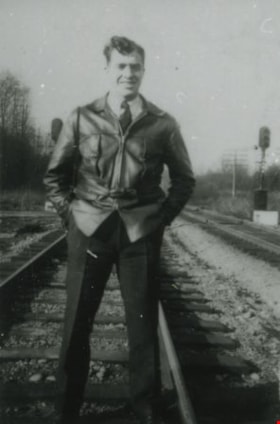
Basil Pontifex
https://search.heritageburnaby.ca/link/archivedescription37903
- Repository
- City of Burnaby Archives
- Date
- January 1948 (date of original), copied 1991
- Collection/Fonds
- Burnaby Historical Society fonds
- Description Level
- Item
- Physical Description
- 1 photograph : b&w ; 3.5 x 2.3 cm print on contact sheet 20.2 x 26.3 cm
- Scope and Content
- Photograph of Basil Pontifex at the Great Northern Railway tracks located around the Burnaby Lake area.
- Repository
- City of Burnaby Archives
- Date
- January 1948 (date of original), copied 1991
- Collection/Fonds
- Burnaby Historical Society fonds
- Subseries
- Burnaby Image Bank subseries
- Physical Description
- 1 photograph : b&w ; 3.5 x 2.3 cm print on contact sheet 20.2 x 26.3 cm
- Description Level
- Item
- Record No.
- 370-491
- Access Restriction
- No restrictions
- Reproduction Restriction
- No known restrictions
- Accession Number
- BHS1999-03
- Scope and Content
- Photograph of Basil Pontifex at the Great Northern Railway tracks located around the Burnaby Lake area.
- Subjects
- Transportation - Rail
- Media Type
- Photograph
- Notes
- Title based on contents of photograph
- 1 b&w copy negative accompanying
- Negative has a pink cast
Images
![Beach with mountains in the background, [1880] thumbnail](/media/hpo/_Data/_Archives_Images/_Unrestricted/477/477-825.jpg?width=280)
Beach with mountains in the background
https://search.heritageburnaby.ca/link/archivedescription39506
- Repository
- City of Burnaby Archives
- Date
- [1880]
- Collection/Fonds
- Peers Family and Hill Family fonds
- Description Level
- Item
- Physical Description
- 1 photograph : sepia ; 11.3 x 17.5 cm on page 21.5 x 28 cm (pasted in album)
- Scope and Content
- Photograph of an unknown beach with mountains in the background. This photograph was in a scrapbook kept by Claude Hill who was originally from England but ultimately settled in the Burnaby Lake area. The photograph was likely taken in England or Wales.
- Repository
- City of Burnaby Archives
- Date
- [1880]
- Collection/Fonds
- Peers Family and Hill Family fonds
- Physical Description
- 1 photograph : sepia ; 11.3 x 17.5 cm on page 21.5 x 28 cm (pasted in album)
- Description Level
- Item
- Record No.
- 477-825
- Access Restriction
- No restrictions
- Reproduction Restriction
- No known restrictions
- Accession Number
- 2007-12
- Scope and Content
- Photograph of an unknown beach with mountains in the background. This photograph was in a scrapbook kept by Claude Hill who was originally from England but ultimately settled in the Burnaby Lake area. The photograph was likely taken in England or Wales.
- Media Type
- Photograph
- Notes
- Title based on contents of photograph
Images
![Beach with mountains in the background, [1880] thumbnail](/media/hpo/_Data/_Archives_Images/_Unrestricted/477/477-825.jpg)
![Bernard Hill's home, [1905] thumbnail](/media/hpo/_Data/_Archives_Images/_Unrestricted/477/477-863.jpg?width=280)
Bernard Hill's home
https://search.heritageburnaby.ca/link/archivedescription39544
- Repository
- City of Burnaby Archives
- Date
- [1905]
- Collection/Fonds
- Peers Family and Hill Family fonds
- Description Level
- Item
- Physical Description
- 1 photograph : b&w ; 7.5 x 10 cm on page 21.5 x 28 cm (pasted in album)
- Scope and Content
- Photograph of the house belonging to Bernard Hill in the Burnaby Lake area on what is now Canada Way. Douglas Road runs through the foreground.
- Repository
- City of Burnaby Archives
- Date
- [1905]
- Collection/Fonds
- Peers Family and Hill Family fonds
- Physical Description
- 1 photograph : b&w ; 7.5 x 10 cm on page 21.5 x 28 cm (pasted in album)
- Description Level
- Item
- Record No.
- 477-863
- Access Restriction
- No restrictions
- Reproduction Restriction
- No known restrictions
- Accession Number
- 2007-12
- Scope and Content
- Photograph of the house belonging to Bernard Hill in the Burnaby Lake area on what is now Canada Way. Douglas Road runs through the foreground.
- Subjects
- Buildings - Residential - Houses
- Media Type
- Photograph
- Notes
- Title based on caption accompanying photograph
- Geographic Access
- Douglas Road
- Canada Way
- Street Address
- 4990 Canada Way
- Historic Neighbourhood
- Burnaby Lake (Historic Neighbourhood)
- Planning Study Area
- Douglas-Gilpin Area
Images
![Bernard Hill's home, [1905] thumbnail](/media/hpo/_Data/_Archives_Images/_Unrestricted/477/477-863.jpg)
![Bird watchers at Piper Pier, [2004] thumbnail](/media/hpo/_Data/_Archives_Images/_Unrestricted/535/535-1757.jpg?width=280)
Bird watchers at Piper Pier
https://search.heritageburnaby.ca/link/archivedescription96006
- Repository
- City of Burnaby Archives
- Date
- [2004]
- Collection/Fonds
- Burnaby NewsLeader photograph collection
- Description Level
- Item
- Physical Description
- 1 photograph (tiff) : col.
- Scope and Content
- Photograph of two bird watchers standing on Piper Pier in Burnaby Lake Regional Park. They are both looking into the distance with binoculars.
- Repository
- City of Burnaby Archives
- Date
- [2004]
- Collection/Fonds
- Burnaby NewsLeader photograph collection
- Physical Description
- 1 photograph (tiff) : col.
- Description Level
- Item
- Record No.
- 535-1757
- Access Restriction
- No restrictions
- Reproduction Restriction
- No restrictions
- Accession Number
- 2018-12
- Scope and Content
- Photograph of two bird watchers standing on Piper Pier in Burnaby Lake Regional Park. They are both looking into the distance with binoculars.
- Media Type
- Photograph
- Photographer
- Bartel, Mario
- Notes
- Title based on caption
- Collected by editorial for use in a January 2004 issue of the Burnaby NewsLeader
- Caption from metadata: "Juliet and Martin Mohlmann say they come down to Piper Pier at Burnaby Lake Regional Park to watch birds about twice a month. But they won't be able to use the pier in the late summer, as the GVRD, the Burnaby Rotary Club and Terasen will be spending $115,000 to rebuild it."
- Geographic Access
- Burnaby Lake Regional Nature Park
- Burnaby Lake
- Historic Neighbourhood
- Burnaby Lake (Historic Neighbourhood)
- Planning Study Area
- Burnaby Lake Area
Images
![Bird watchers at Piper Pier, [2004] thumbnail](/media/hpo/_Data/_Archives_Images/_Unrestricted/535/535-1757.jpg)
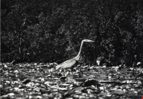
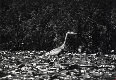
Blue Heron
https://search.heritageburnaby.ca/link/archivedescription79878
- Repository
- City of Burnaby Archives
- Date
- September, 1976
- Collection/Fonds
- Burnaby Public Library Contemporary Visual Archive Project
- Description Level
- Item
- Physical Description
- 1 photograph : b&w ; 11 x 16 cm mounted on cardboard
- Scope and Content
- Photograph shows a blue heron near the shore of Burnaby Lake - one of the more than 180 species of bird and animal life that have been identified in the Burnaby Lake area.
- Repository
- City of Burnaby Archives
- Date
- September, 1976
- Collection/Fonds
- Burnaby Public Library Contemporary Visual Archive Project
- Physical Description
- 1 photograph : b&w ; 11 x 16 cm mounted on cardboard
- Description Level
- Item
- Record No.
- 556-480
- Access Restriction
- No restrictions
- Reproduction Restriction
- Reproduce for fair dealing purposes only
- Accession Number
- 2013-13
- Scope and Content
- Photograph shows a blue heron near the shore of Burnaby Lake - one of the more than 180 species of bird and animal life that have been identified in the Burnaby Lake area.
- Subjects
- Animals - Birds
- Media Type
- Photograph
- Photographer
- Salmon, Stu
- Notes
- Scope note taken directly from BPL photograph description.
- 1 b&w copy negative : 10 x 12.5 cm accompanying
- Geographic Access
- Burnaby Lake
- Historic Neighbourhood
- Burnaby Lake (Historic Neighbourhood)
Images
![Boal family home, [1938 or 1939] thumbnail](/media/hpo/_Data/_BVM_Images/2017/201700280020_001.jpg?width=280)
Boal family home
https://search.heritageburnaby.ca/link/museumdescription4213
- Repository
- Burnaby Village Museum
- Date
- [1938 or 1939]
- Collection/Fonds
- Burnaby Village Museum Photograph collection
- Description Level
- Item
- Physical Description
- 1 photograph : b&w ; 8 x 12 cm
- Scope and Content
- Photograph of the Boal home at 4319 Norland Ave in Burnaby. The photo is face on to the house looking west(?), the whole house is shown. Mr and Mrs Boal (William Ewart Boal and Ethel May Boal, nee Jackson) are standing on the front porch.
- Repository
- Burnaby Village Museum
- Collection/Fonds
- Burnaby Village Museum Photograph collection
- Description Level
- Item
- Physical Description
- 1 photograph : b&w ; 8 x 12 cm
- Material Details
- Stamped numeral on back of photograph reads: "305".
- Scope and Content
- Photograph of the Boal home at 4319 Norland Ave in Burnaby. The photo is face on to the house looking west(?), the whole house is shown. Mr and Mrs Boal (William Ewart Boal and Ethel May Boal, nee Jackson) are standing on the front porch.
- History
- Material belonged to Glen and Ann Boal (nee Lockhart), who grew up in Burnaby and attended Burnaby South High School. They met and became engaged and married in 1954.
- Geographic Access
- Norland Avenue
- Street Address
- 4319 Norland Avenue
- Accession Code
- BV017.28.20
- Access Restriction
- No restrictions
- Reproduction Restriction
- No known restrictions
- Date
- [1938 or 1939]
- Media Type
- Photograph
- Historic Neighbourhood
- Burnaby Lake (Historic Neighbourhood)
- Planning Study Area
- Burnaby Lake Area
- Scan Resolution
- 600
- Scan Date
- 06-Mar-2018
- Notes
- Title based on contents of photograph
Images
![Boal family home, [1938 or 1939] thumbnail](/media/hpo/_Data/_BVM_Images/2017/201700280020_001.jpg)