Narrow Results By
Dania Home
https://search.heritageburnaby.ca/link/archivedescription34585
- Repository
- City of Burnaby Archives
- Date
- 1958
- Collection/Fonds
- Burnaby Historical Society fonds
- Description Level
- Item
- Physical Description
- 1 photograph : b&w ; 17.8 x 22.7 cm
- Scope and Content
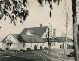
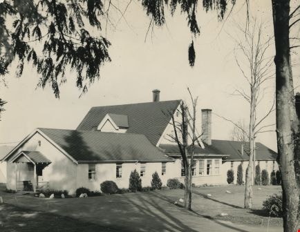
- Photograph of the exterior of the Dania Home at 4279 Norland Avenue and Canada Way. The accompanying description reads, "Dania - Modern Danish Rest Home / On site pioneer estate of C.F. Sprott, one of first reeves of Burnaby, Douglas Road - near Norland." The original house, at the centre of the b…
- Repository
- City of Burnaby Archives
- Date
- 1958
- Collection/Fonds
- Burnaby Historical Society fonds
- Subseries
- Photographs subseries
- Physical Description
- 1 photograph : b&w ; 17.8 x 22.7 cm
- Description Level
- Item
- Record No.
- 059-001
- Access Restriction
- No restrictions
- Reproduction Restriction
- Reproduce for fair dealing purposes only
- Accession Number
- BHS2007-04
- Scope and Content
- Photograph of the exterior of the Dania Home at 4279 Norland Avenue and Canada Way. The accompanying description reads, "Dania - Modern Danish Rest Home / On site pioneer estate of C.F. Sprott, one of first reeves of Burnaby, Douglas Road - near Norland." The original house, at the centre of the building, was one of the earliest homes in the Burnaby Lake area, built in 1891 by Charles F. Sprott with the assistance of Bernard R. Hill.
- Names
- Dania Home
- Media Type
- Photograph
- Notes
- Title based on contents of photograph
- Geographic Access
- Norland Avenue
- Street Address
- 4279 Norland Avenue
- Historic Neighbourhood
- Burnaby Lake (Historic Neighbourhood)
- Planning Study Area
- Douglas-Gilpin Area
Images
![Unchannelled portion of Burnaby Lake, September 1952 (date of original), copied [1985] thumbnail](/media/hpo/_Data/_BVM_Images/1985/1985_0457_0003_001.jpg?width=280)
Unchannelled portion of Burnaby Lake
https://search.heritageburnaby.ca/link/museumdescription10584
- Repository
- Burnaby Village Museum
- Date
- September 1952 (date of original), copied [1985]
- Collection/Fonds
- Burnaby Village Museum Photograph collection
- Description Level
- Item
- Physical Description
- 1 photograph : b&w copy negative ; 10 x 12.5 cm
- Scope and Content
- Photograph of unchannelled portion of Burnaby Lake, September 1952. The surface of the lake is covered with lily pads.
- Repository
- Burnaby Village Museum
- Collection/Fonds
- Burnaby Village Museum Photograph collection
- Description Level
- Item
- Physical Description
- 1 photograph : b&w copy negative ; 10 x 12.5 cm
- Scope and Content
- Photograph of unchannelled portion of Burnaby Lake, September 1952. The surface of the lake is covered with lily pads.
- Accession Code
- BV985.457.3
- Access Restriction
- No restrictions
- Reproduction Restriction
- May be restricted by third party rights
- Date
- September 1952 (date of original), copied [1985]
- Media Type
- Photograph
- Historic Neighbourhood
- Burnaby Lake (Historic Neighbourhood)
- Planning Study Area
- Burnaby Lake Area
- Scan Resolution
- 1200
- Scan Date
- 2022-06-07
- Photographer
- Lindsay, Jack
- Notes
- Title based on contents of photograph
Images
![Unchannelled portion of Burnaby Lake, September 1952 (date of original), copied [1985] thumbnail](/media/hpo/_Data/_BVM_Images/1985/1985_0457_0003_001.jpg)

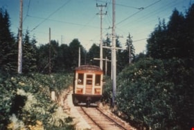
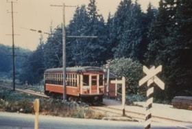
Burnaby Lake Tram #1234
https://search.heritageburnaby.ca/link/archivedescription35990
- Repository
- City of Burnaby Archives
- Date
- May 1951
- Collection/Fonds
- Burnaby Historical Society fonds
- Description Level
- Item
- Physical Description
- 1 photograph : col. ; 10 x 15 cm print
- Scope and Content
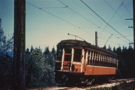
- Photograph of Tram #1234 on the Burnaby Lake Interurban line, near Stormont station.
- Repository
- City of Burnaby Archives
- Date
- May 1951
- Collection/Fonds
- Burnaby Historical Society fonds
- Subseries
- Geoff Meugans subseries
- Physical Description
- 1 photograph : col. ; 10 x 15 cm print
- Description Level
- Item
- Record No.
- 208-001
- Access Restriction
- No restrictions
- Reproduction Restriction
- Reproduce for fair dealing purposes only
- Accession Number
- BHS1988-08
- Scope and Content
- Photograph of Tram #1234 on the Burnaby Lake Interurban line, near Stormont station.
- Subjects
- Transportation - Electric Railroads
- Media Type
- Photograph
- Notes
- Title based on contents of photograph
- Geographic Access
- Burnaby Lake Interurban line
- Planning Study Area
- Burnaby Lake Area
Images
Burnaby Lake Tram #1228
https://search.heritageburnaby.ca/link/archivedescription35991
- Repository
- City of Burnaby Archives
- Date
- June 1951
- Collection/Fonds
- Burnaby Historical Society fonds
- Description Level
- Item
- Physical Description
- 1 photograph : col. ; 10 x 15 cm print
- Scope and Content
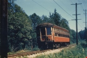
- Photograph of Tram #1228 on the Burnaby Lake Interurban line, near Stormont station.
- Repository
- City of Burnaby Archives
- Date
- June 1951
- Collection/Fonds
- Burnaby Historical Society fonds
- Subseries
- Geoff Meugans subseries
- Physical Description
- 1 photograph : col. ; 10 x 15 cm print
- Description Level
- Item
- Record No.
- 208-002
- Access Restriction
- No restrictions
- Reproduction Restriction
- Reproduce for fair dealing purposes only
- Accession Number
- BHS1988-08
- Scope and Content
- Photograph of Tram #1228 on the Burnaby Lake Interurban line, near Stormont station.
- Subjects
- Transportation - Electric Railroads
- Media Type
- Photograph
- Notes
- Title based on contents of photograph
- Geographic Access
- Burnaby Lake Interurban line
- Planning Study Area
- Burnaby Lake Area
Images

Burnaby Lake Tram #1233
https://search.heritageburnaby.ca/link/archivedescription35992
- Repository
- City of Burnaby Archives
- Date
- June 1951
- Collection/Fonds
- Burnaby Historical Society fonds
- Description Level
- Item
- Physical Description
- 1 photograph : col. ; 10 x 15 cm print
- Scope and Content
- Photograph of the caboose of Tram #1233, on the Burnaby Lake Interurban line, near Cariboo station.
- Repository
- City of Burnaby Archives
- Date
- June 1951
- Collection/Fonds
- Burnaby Historical Society fonds
- Subseries
- Geoff Meugans subseries
- Physical Description
- 1 photograph : col. ; 10 x 15 cm print
- Description Level
- Item
- Record No.
- 208-003
- Access Restriction
- No restrictions
- Reproduction Restriction
- Reproduce for fair dealing purposes only
- Accession Number
- BHS1988-08
- Scope and Content
- Photograph of the caboose of Tram #1233, on the Burnaby Lake Interurban line, near Cariboo station.
- Subjects
- Transportation - Electric Railroads
- Media Type
- Photograph
- Notes
- Title based on contents of photograph
- Geographic Access
- Burnaby Lake Interurban line
- Planning Study Area
- Burnaby Lake Area
Images

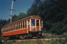
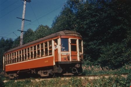
Burnaby Lake Tram #1235
https://search.heritageburnaby.ca/link/archivedescription35993
- Repository
- City of Burnaby Archives
- Date
- July 1951
- Collection/Fonds
- Burnaby Historical Society fonds
- Description Level
- Item
- Physical Description
- 1 photograph : col. ; 10 x 15 cm print
- Scope and Content
- Photograph of Tram #1235 on the Burnaby Lake Interurban line, near Cumberland Road station. The tram conductor can be seen poking his head out of the side door as he drives.
- Repository
- City of Burnaby Archives
- Date
- July 1951
- Collection/Fonds
- Burnaby Historical Society fonds
- Subseries
- Geoff Meugans subseries
- Physical Description
- 1 photograph : col. ; 10 x 15 cm print
- Description Level
- Item
- Record No.
- 208-004
- Access Restriction
- No restrictions
- Reproduction Restriction
- Reproduce for fair dealing purposes only
- Accession Number
- BHS1988-08
- Scope and Content
- Photograph of Tram #1235 on the Burnaby Lake Interurban line, near Cumberland Road station. The tram conductor can be seen poking his head out of the side door as he drives.
- Subjects
- Transportation - Electric Railroads
- Media Type
- Photograph
- Notes
- Title based on contents of photograph
- Geographic Access
- Burnaby Lake Interurban line
- Planning Study Area
- Burnaby Lake Area
Images
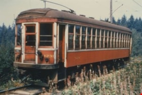
Burnaby Lake Tram #1231
https://search.heritageburnaby.ca/link/archivedescription35994
- Repository
- City of Burnaby Archives
- Date
- August 1951
- Collection/Fonds
- Burnaby Historical Society fonds
- Description Level
- Item
- Physical Description
- 1 photograph : col. ; 10 x 15 cm print
- Scope and Content
- Photograph of Tram #1231 on the Burnaby Lake Interurban line, near Stormont station.
- Repository
- City of Burnaby Archives
- Date
- August 1951
- Collection/Fonds
- Burnaby Historical Society fonds
- Subseries
- Geoff Meugans subseries
- Physical Description
- 1 photograph : col. ; 10 x 15 cm print
- Description Level
- Item
- Record No.
- 208-005
- Access Restriction
- No restrictions
- Reproduction Restriction
- Reproduce for fair dealing purposes only
- Accession Number
- BHS1988-08
- Scope and Content
- Photograph of Tram #1231 on the Burnaby Lake Interurban line, near Stormont station.
- Subjects
- Transportation - Electric Railroads
- Media Type
- Photograph
- Notes
- Title based on contents of photograph
- Geographic Access
- Burnaby Lake Interurban line
- Planning Study Area
- Burnaby Lake Area
Images

Burnaby Lake Tram #1230
https://search.heritageburnaby.ca/link/archivedescription35996
- Repository
- City of Burnaby Archives
- Date
- August 1951
- Collection/Fonds
- Burnaby Historical Society fonds
- Description Level
- Item
- Physical Description
- 1 photograph : col. ; 10 x 15 cm print
- Scope and Content
- Photograph of Tram #1230 on the Burnaby Lake Interurban line, at Cariboo station's level crossing.
- Repository
- City of Burnaby Archives
- Date
- August 1951
- Collection/Fonds
- Burnaby Historical Society fonds
- Subseries
- Geoff Meugans subseries
- Physical Description
- 1 photograph : col. ; 10 x 15 cm print
- Description Level
- Item
- Record No.
- 208-007
- Access Restriction
- No restrictions
- Reproduction Restriction
- Reproduce for fair dealing purposes only
- Accession Number
- BHS1988-08
- Scope and Content
- Photograph of Tram #1230 on the Burnaby Lake Interurban line, at Cariboo station's level crossing.
- Media Type
- Photograph
- Notes
- Title based on contents of photograph
- Geographic Access
- Burnaby Lake Interurban line
- Planning Study Area
- Burnaby Lake Area
Images

![Dredge for clearing channel through Burnaby Lake, March 1951 (date of original), copied [1985] thumbnail](/media/hpo/_Data/_BVM_Images/1985/1985_0457_0004_001.jpg?width=280)
Dredge for clearing channel through Burnaby Lake
https://search.heritageburnaby.ca/link/museumdescription10585
- Repository
- Burnaby Village Museum
- Date
- March 1951 (date of original), copied [1985]
- Collection/Fonds
- Burnaby Village Museum Photograph collection
- Description Level
- Item
- Physical Description
- 1 photograph : b&w copy negative ; 10 x 12.5 cm
- Scope and Content
- Photograph of dredge for clearing channel through Burnaby Lake, March 1951.
- Repository
- Burnaby Village Museum
- Collection/Fonds
- Burnaby Village Museum Photograph collection
- Description Level
- Item
- Physical Description
- 1 photograph : b&w copy negative ; 10 x 12.5 cm
- Scope and Content
- Photograph of dredge for clearing channel through Burnaby Lake, March 1951.
- Accession Code
- BV985.457.4
- Access Restriction
- No restrictions
- Reproduction Restriction
- May be restricted by third party rights
- Date
- March 1951 (date of original), copied [1985]
- Media Type
- Photograph
- Historic Neighbourhood
- Burnaby Lake (Historic Neighbourhood)
- Planning Study Area
- Burnaby Lake Area
- Scan Resolution
- 1200
- Scan Date
- 2022-06-07
- Photographer
- Lindsay, Jack
- Notes
- Title based on contents of photograph
Images
![Dredge for clearing channel through Burnaby Lake, March 1951 (date of original), copied [1985] thumbnail](/media/hpo/_Data/_BVM_Images/1985/1985_0457_0004_001.jpg)
![View from dredge, 1951 (date of original), copied [1985] thumbnail](/media/hpo/_Data/_BVM_Images/1985/1985_0457_0005_001.jpg?width=280)
View from dredge
https://search.heritageburnaby.ca/link/museumdescription10586
- Repository
- Burnaby Village Museum
- Date
- 1951 (date of original), copied [1985]
- Collection/Fonds
- Burnaby Village Museum Photograph collection
- Description Level
- Item
- Physical Description
- 1 photograph : b&w copy negative ; 10 x 12.5 cm
- Scope and Content
- Photograph of dredge for clearing channel through Burnaby Lake, March 1951. The surface of the lake is covered with lily pads.
- Repository
- Burnaby Village Museum
- Collection/Fonds
- Burnaby Village Museum Photograph collection
- Description Level
- Item
- Physical Description
- 1 photograph : b&w copy negative ; 10 x 12.5 cm
- Scope and Content
- Photograph of dredge for clearing channel through Burnaby Lake, March 1951. The surface of the lake is covered with lily pads.
- Accession Code
- BV985.457.5
- Access Restriction
- No restrictions
- Reproduction Restriction
- May be restricted by third party rights
- Date
- 1951 (date of original), copied [1985]
- Media Type
- Photograph
- Historic Neighbourhood
- Burnaby Lake (Historic Neighbourhood)
- Planning Study Area
- Burnaby Lake Area
- Scan Resolution
- 1200
- Scan Date
- 2022-06-07
- Photographer
- Lindsay, Jack
- Notes
- Title based on contents of photograph
Images
![View from dredge, 1951 (date of original), copied [1985] thumbnail](/media/hpo/_Data/_BVM_Images/1985/1985_0457_0005_001.jpg)
![Working dredge, March 1951 (date of original), copied [1985] thumbnail](/media/hpo/_Data/_BVM_Images/1985/1985_0457_0006_001.jpg?width=280)
Working dredge
https://search.heritageburnaby.ca/link/museumdescription10587
- Repository
- Burnaby Village Museum
- Date
- March 1951 (date of original), copied [1985]
- Collection/Fonds
- Burnaby Village Museum Photograph collection
- Description Level
- Item
- Physical Description
- 1 photograph : b&w copy negative ; 10 x 12.5 cm
- Scope and Content
- Photograph of working dredge for clearing channel through Burnaby Lake, March 1951.
- Repository
- Burnaby Village Museum
- Collection/Fonds
- Burnaby Village Museum Photograph collection
- Description Level
- Item
- Physical Description
- 1 photograph : b&w copy negative ; 10 x 12.5 cm
- Scope and Content
- Photograph of working dredge for clearing channel through Burnaby Lake, March 1951.
- Accession Code
- BV985.457.6
- Access Restriction
- No restrictions
- Reproduction Restriction
- May be restricted by third party rights
- Date
- March 1951 (date of original), copied [1985]
- Media Type
- Photograph
- Historic Neighbourhood
- Burnaby Lake (Historic Neighbourhood)
- Planning Study Area
- Burnaby Lake Area
- Scan Resolution
- 1200
- Scan Date
- 2022-06-07
- Photographer
- Lindsay, Jack
- Notes
- Title based on contents of photograph
Images
![Working dredge, March 1951 (date of original), copied [1985] thumbnail](/media/hpo/_Data/_BVM_Images/1985/1985_0457_0006_001.jpg)
![Channel after dredging operation, 1951 (date of original), copied [1985] thumbnail](/media/hpo/_Data/_BVM_Images/1985/1985_0457_0007_001.jpg?width=280)
Channel after dredging operation
https://search.heritageburnaby.ca/link/museumdescription10588
- Repository
- Burnaby Village Museum
- Date
- 1951 (date of original), copied [1985]
- Collection/Fonds
- Burnaby Village Museum Photograph collection
- Description Level
- Item
- Physical Description
- 1 photograph : b&w copy negative ; 10 x 12.5 cm
- Scope and Content
- Photograph of channel of Burnaby Lake after dredging operation, 1951.
- Repository
- Burnaby Village Museum
- Collection/Fonds
- Burnaby Village Museum Photograph collection
- Description Level
- Item
- Physical Description
- 1 photograph : b&w copy negative ; 10 x 12.5 cm
- Scope and Content
- Photograph of channel of Burnaby Lake after dredging operation, 1951.
- Accession Code
- BV985.457.7
- Access Restriction
- No restrictions
- Reproduction Restriction
- May be restricted by third party rights
- Date
- 1951 (date of original), copied [1985]
- Media Type
- Photograph
- Historic Neighbourhood
- Burnaby Lake (Historic Neighbourhood)
- Planning Study Area
- Burnaby Lake Area
- Scan Resolution
- 1200
- Scan Date
- 2022-06-07
- Notes
- Title based on contents of photograph
Images
![Channel after dredging operation, 1951 (date of original), copied [1985] thumbnail](/media/hpo/_Data/_BVM_Images/1985/1985_0457_0007_001.jpg)
![Boal family home, [1950] thumbnail](/media/hpo/_Data/_BVM_Images/2017/201700280022_001.jpg?width=280)
Boal family home
https://search.heritageburnaby.ca/link/museumdescription4215
- Repository
- Burnaby Village Museum
- Date
- [1950]
- Collection/Fonds
- Burnaby Village Museum Photograph collection
- Description Level
- Item
- Physical Description
- 1 photograph : b&w ; 6.5 x 9 cm
- Scope and Content
- Photograph of the Boal home at 4319 Norland Ave in Burnaby. This is a three-quarter shot of the house which has new, light coloured siding (white?) and a garage in the back. A man is mowing the lawn next to the house.
- Repository
- Burnaby Village Museum
- Collection/Fonds
- Burnaby Village Museum Photograph collection
- Description Level
- Item
- Physical Description
- 1 photograph : b&w ; 6.5 x 9 cm
- Material Details
- Handwritten text in ink on front of photograph reads: "1950".
- Stamped numeral on back of photograph reads: "452".
- Handwritten text on back of photograph reads: "summer, 1950 / Boals' house".
- Scope and Content
- Photograph of the Boal home at 4319 Norland Ave in Burnaby. This is a three-quarter shot of the house which has new, light coloured siding (white?) and a garage in the back. A man is mowing the lawn next to the house.
- History
- Material belonged to Glen and Ann Boal (nee Lockhart), who grew up in Burnaby and attended Burnaby South High School. They met and became engaged and married in 1954.
- Geographic Access
- Norland Avenue
- Street Address
- 4319 Norland Avenue
- Accession Code
- BV017.28.22
- Access Restriction
- No restrictions
- Reproduction Restriction
- No known restrictions
- Date
- [1950]
- Media Type
- Photograph
- Historic Neighbourhood
- Burnaby Lake (Historic Neighbourhood)
- Planning Study Area
- Burnaby Lake Area
- Scan Resolution
- 600
- Scan Date
- 06-Mar-2018
- Notes
- Title based on contents of photograph
Images
![Boal family home, [1950] thumbnail](/media/hpo/_Data/_BVM_Images/2017/201700280022_001.jpg)
![Boal family home, [195-] thumbnail](/media/hpo/_Data/_BVM_Images/2017/201700280023_001.jpg?width=280)
Boal family home
https://search.heritageburnaby.ca/link/museumdescription4216
- Repository
- Burnaby Village Museum
- Date
- [195-]
- Collection/Fonds
- Burnaby Village Museum Photograph collection
- Description Level
- Item
- Physical Description
- 1 photograph : col. ; 9 x 13 cm
- Scope and Content
- Photograph of the Boal home at 4319 Norland Ave in Burnaby. This is a three-quarter shot of the house. The house has been altered by enclosing the front porch and lowering the front door to ground level. Doors and window sills are painted light blue. Window shutters have been added. The house is wh…
- Repository
- Burnaby Village Museum
- Collection/Fonds
- Burnaby Village Museum Photograph collection
- Description Level
- Item
- Physical Description
- 1 photograph : col. ; 9 x 13 cm
- Scope and Content
- Photograph of the Boal home at 4319 Norland Ave in Burnaby. This is a three-quarter shot of the house. The house has been altered by enclosing the front porch and lowering the front door to ground level. Doors and window sills are painted light blue. Window shutters have been added. The house is white. There are trees in full leaf around the house.
- History
- Material belonged to Glen and Ann Boal (nee Lockhart), who grew up in Burnaby and attended Burnaby South High School. They met and became engaged and married in 1954.
- Geographic Access
- Norland Avenue
- Street Address
- 4319 Norland Avenue
- Accession Code
- BV017.28.23
- Access Restriction
- No restrictions
- Reproduction Restriction
- No known restrictions
- Date
- [195-]
- Media Type
- Photograph
- Historic Neighbourhood
- Burnaby Lake (Historic Neighbourhood)
- Planning Study Area
- Burnaby Lake Area
- Scan Resolution
- 600
- Scan Date
- 06-Mar-2018
- Notes
- Title based on contents of photograph
Images
![Boal family home, [195-] thumbnail](/media/hpo/_Data/_BVM_Images/2017/201700280023_001.jpg)

Knight family photographs
https://search.heritageburnaby.ca/link/archivedescription64501
- Repository
- City of Burnaby Archives
- Date
- 1948-1971
- Collection/Fonds
- Burnaby Historical Society fonds
- Description Level
- File
- Physical Description
- 49 photographs (35 prints : b&w and col. and 14 negatives : b&w)
- Scope and Content
- Photographs of "the Bird Doctor" Virginia Knight and her husband Milton and their properties, avaries, and pets. File also includes the couple's travel photographs, photograph's of Milton's antique clock and watch collection, and images of Lakeview Aviaries in Burnaby.
- Repository
- City of Burnaby Archives
- Date
- 1948-1971
- Collection/Fonds
- Burnaby Historical Society fonds
- Subseries
- Knight family subseries
- Physical Description
- 49 photographs (35 prints : b&w and col. and 14 negatives : b&w)
- Description Level
- File
- Record No.
- 510-001
- Access Restriction
- No restrictions
- Reproduction Restriction
- May be restricted by third party rights
- Accession Number
- BHS1992-53
- Scope and Content
- Photographs of "the Bird Doctor" Virginia Knight and her husband Milton and their properties, avaries, and pets. File also includes the couple's travel photographs, photograph's of Milton's antique clock and watch collection, and images of Lakeview Aviaries in Burnaby.
- Media Type
- Photograph
- Notes
- Title based on contents of photographs
- Stamp on verso of 510-001 reads: "Woodward's Advertising Photography"
- Note on verso of 510-003 reads: "Taken at San Juan Capistrano. The minute you enter the place these pigeons light all over you and they sell you small bags of wheat to feed them." Other notes and date stamp on verso.
- Note on verso of 510-010 reads: "Virgie + Sheila Joan (Easton) Mulliner / New Year's Eve / 1970-71"
- 510-008, 510-009, 510-011, 510-012: Date stamp on verso reads "Jan 12, 1962"
- Note on verso of 510-022 reads: "My little Saw-Whet Owl who was one of my patients. Fully recovered and hand tame."
- 510-024 is five small photographs glued to a black paper album page
- Handwritten notes on recto of 510-032, describing the clocks in the photograph.
- Geographic Access
- Deer Lake
- Street Address
- 5255 Sperling Avenue
- Historic Neighbourhood
- Burnaby Lake (Historic Neighbourhood)
- Planning Study Area
- Burnaby Lake Area
Images

Small family fonds
https://search.heritageburnaby.ca/link/archivedescription91819
- Repository
- City of Burnaby Archives
- Date
- 1922-2016
- Collection/Fonds
- Small family fonds
- Description Level
- Fonds
- Physical Description
- 75 photographs : b&w & col. + 1 plan
- Scope and Content
- Fonds consists of photographs documenting the transformation of the Burnaby Lake area of Burnaby, B.C. from semi-rural in the 1920s to urbanized in 2016. Photographs depict the land and houses located on the corner of Douglas Road and Dominion Street as the property was rezoned and its density quad…
- Repository
- City of Burnaby Archives
- Date
- 1922-2016
- Collection/Fonds
- Small family fonds
- Physical Description
- 75 photographs : b&w & col. + 1 plan
- Description Level
- Fonds
- Access Restriction
- Open access
- Reproduction Restriction
- May be restricted by third party rights
- Accession Number
- 2017-01
- Scope and Content
- Fonds consists of photographs documenting the transformation of the Burnaby Lake area of Burnaby, B.C. from semi-rural in the 1920s to urbanized in 2016. Photographs depict the land and houses located on the corner of Douglas Road and Dominion Street as the property was rezoned and its density quadrupled. Fonds also includes photographs of the Small family house being moved to 5496 Dominion Street and the original landscape plan for 5118 Douglas Road.
- History
- In 1915, John W. Roberts and his wife Mary Allen Roberts moved from the United States to Canada along with their daughter, Lauretta. On first moving to Canada, the family lived in a rented house in Vancouver and John worked as a movie projectionist in the city. The couple had three more children, all sons: John A., Edward, and Roland. Circa 1921, John purchased a large parcel of land at the corner of Douglas Road and Dominion Street in Burnaby. This parcel encompassed the equivalent of at least six 66-foot lots along the south side of Dominion Street and the same along the north side of Norfolk Street. On their property, a barn and small living quarters were built. The family moved in, raising goats and growing potatoes to supplement their income. They also planted cherry, apple, and pear trees; hazelnut and walnut trees; raspberries; and a large vegetable garden, the fruits of which Mary preserved for year-round use. At this time, agricultural activities were common for families in the area: the Roberts' neighbours kept chickens for personal use and for selling eggs; grew mushrooms for commercial sale; and sold manure from an old buckboard drawn by Clydesdale horses. John built a new house in the middle of the Roberts’ lots on the southwest corner of Douglas Road and Dominion Street. The house faced Douglas Road and overlooked a large, well-landscaped front yard to the east and a full-sized, clay tennis court to the north. The family moved into this new house in 1925. When the Roberts ceased raising goats, the barn and original living quarters were reduced to a double-car garage with storage space plus a sawdust-insulated “root cellar”. John also built a house on the northwest corner of the lot at Douglas Road and Dominion Street (3093 Douglas Road), which was purchased by the Hardy family. In 1957, part of this property (3071 Douglas Road) was sold to the Brocklebanks who built a house and lived there. In addition, John built a house at the northwest corner of Douglas Road and Norfolk Street (5106 Douglas Road). The original purchaser of this house is unknown, but in 1949, it was bought by the Meyers family. In 1952 or 1953, the Meyers sold part of this property and the Manahans built a house on it, facing Douglas Road. Several other lots that John owned were also sold off over the years. By the 1950s, John owned only five 66-foot lots from Douglas Road west, along the south side Dominion Street. In 1954, John sold the lot furthest from Douglas Road (5486 Dominion Street) to a builder who built a “ranch-style” house and put it up for sale. John retired from his career as a movie projectionist in the 1950s. He, Mary, and Lauretta retained their US citizenship all their lives, although they never returned to the USA except for brief visits. John A., Edward, and Roland who, as children of US citizens, also had US citizenship, eventually moved to the US, where they remained for the rest of their lives. In 1945, Lauretta married Frederick Small. The couple lived in a rented house in Vancouver for a few years before moving in with John and Mary in Burnaby. The couple had four children: Elizabeth, Kathryn, Charles, and Martin. In 1955, Frederick purchased the rancher at 5486 Dominion Street and the family moved in. The Small children grew up enjoying the freedom of having their grandparent’s large property in addition to their parent’s yard to play in. The back lane that ran between Dominion Street and Norfolk Street was filled with trees and bushes, creating a narrow bit of “forest” to explore. In 1957, John died. Mary died in 1969, as did Frederick. Lauretta was executor for her mother’s and husband’s estates. After much consideration, she decided to sell the house at 5486 Dominion Street and move back into her childhood home. By doing so, she was able to settle her mother’s estate to the satisfaction of her brothers. Elizabeth married and moved away. Over the next few years, the “Roberts” house was home to Lauretta, Kathryn, Charles, and Martin, with the three grown children moving in and out several times during the 1970s. In 1981, Lauretta died. Her children discussed at length how to divide up the property, which consisted of four 66-foot lots, according to her will. None of her children wanted to see the old family house destroyed but the house straddled two lots. They finally decided that if one of them wanted to pay to move the house to sit on one of the lots, the “value” of the house would not enter into the settlement of the estate. Kathryn chose to do this. In 1982, the old house was moved to 5496 Dominion Street and Kathryn continued to live in it. Martin died in 1982. Elizabeth and Charles each inherited one lot and the last lot, which would have gone to Martin, was sold, the funds divided equally between Elizabeth, Kathryn, and Charles. The three lots between 5496 Dominion Street and Douglas Road were subdivided into 33-foot lots and six new houses were built. In 1993, the Meyers property and the Manahan property were subdivided into 33-foot lots facing Norfolk Street and the old houses were torn down and four new houses were built.
- Media Type
- Photograph
- Technical Drawing
- Creator
- Small family
Ross family subseries
https://search.heritageburnaby.ca/link/archivedescription114
- Repository
- City of Burnaby Archives
- Date
- 1922(date of originals)-[1998]
- Collection/Fonds
- Burnaby Historical Society fonds
- Description Level
- Subseries
- Physical Description
- 2 files of textual records and 2 photographs
- Scope and Content
- Subseries consists of Ross family history, memories of the Burnaby Lake Interurban, Ross Service Station letterhead and photographs of the Ross Service Station.
- Repository
- City of Burnaby Archives
- Date
- 1922(date of originals)-[1998]
- Collection/Fonds
- Burnaby Historical Society fonds
- Subseries
- Ross family subseries
- Physical Description
- 2 files of textual records and 2 photographs
- Description Level
- Subseries
- Accession Number
- BHS1998-05
- BHS1999-14
- Scope and Content
- Subseries consists of Ross family history, memories of the Burnaby Lake Interurban, Ross Service Station letterhead and photographs of the Ross Service Station.
- History
- Frederick "Fred" Sullivan Ross was born 1887 in Edinburgh, Scotland. He took his apprenticeship in mechanics in Glasgow prior to 1911, following which he immigrated to Canada. During the First World War he returned to Britain and joined the Royal Navy. He was a Chief Petty Officer, working in the engine room of a mine sweeper in the North Atlantic. Margaret Binnie Dougal was in 1884 in Linlithgow, Scotland. She trained as a nurse before emigrating to Canada in 1911. She also returned to Britain during the war years, nursing at Boulogne in France and later Bristol before returning to Vancouver in 1919. She met Fred through a mutual friend, Agnes Rhind. Fred and Margaret married in 1920 in Vancouver, BC. Their first home was in North Vancouver and was where their first child, Ronald, was born. In 1921 or 1922 they moved to the Burnaby Lake area, buying a three-quarter acre parcel of land at 2974 Sprott Street and had two more children, Ian and Alistair. Fred built, owned and operated the Ross Service Station on Douglas Road, established in 1922 or 1923. The station property ran from Douglas Road up to the Douglas Road School’s fence line. After the municipality appropriated part of the property in the 1930s to create a junction for the new Grandview Highway and existing Douglas Road, Fred got permission to build an upper station with two more pumps. The driveway curved down to the station from where Sprott Street now joins Canada Way and rejoined that road near its junction with Douglas Road. At Ross Service Station, Fred did automobile repairs and used the family car, a Studebaker Commander, as a towing vehicle. He created a garden north of the service station on the upper level where he grew chrysanthemums and daises. In the 1930s, Terry Rowley worked at the service station as one of Fred’s assistants. Fred ran the station until he sold it in about 1949. Margaret died December 29, 1969 at the age of 85. Fred died on August 21, 1971 at the age of 84.
- Media Type
- Textual Record
- Photograph
- Creator
- Ross family
- Notes
- Title based on contents of subseries
- PC58 and MSS146
Peers Family and Hill Family fonds
https://search.heritageburnaby.ca/link/archivedescription98
- Repository
- City of Burnaby Archives
- Date
- [1880-1980]
- Collection/Fonds
- Peers Family and Hill Family fonds
- Description Level
- Fonds
- Physical Description
- ca. 1200 photographs and other material
- Scope and Content
- Fonds consists of records, primarily photographs, compiled by various members of both the Hill and Peers families that document their lives during the early days of settlement in Burnaby. The fonds includes records of citizenship, wills and other official papers pertaining to the life and activitie…
- Repository
- City of Burnaby Archives
- Date
- [1880-1980]
- Collection/Fonds
- Peers Family and Hill Family fonds
- Physical Description
- ca. 1200 photographs and other material
- Description Level
- Fonds
- Access Restriction
- No restrictions
- Accession Number
- 2007-12
- Scope and Content
- Fonds consists of records, primarily photographs, compiled by various members of both the Hill and Peers families that document their lives during the early days of settlement in Burnaby. The fonds includes records of citizenship, wills and other official papers pertaining to the life and activities of L. Claude Hill; photographs of the Peers family’s Burnaby Lake home, Greyfriars, and pictures taken by Arthur Peers during his work and travels throughout British Columbia in the first part of the 20th century; and photographs of the family of Claude Hill, early Burnaby Lake residents and scenes, and pictures Kitty took as an adult documenting the growth of her own family. Also included in this fonds are a number of photographs showing Yellow Point, Vancouver Island, where the Peers and Hill families often vacationed.
- History
- Bob Peers was born William John Peers, the son of real estate broker and early Burnaby resident, Francis John Peers and his wife Elizabeth Frisby. Originally from England, the family moved to Vancouver in 1905 and soon after settled at Burnaby Lake. The family included one daughter (Mary Elizabeth Dora) and four boys (Arthur Francis, William John “Bob”, Geoffrey Hugh, and Richard Dominic). When they arrived in Burnaby, Francis Peers purchased a piece of land from another early settler, Claude Hill, and built the family home “Greyfriars” near Deer Lake. The children attended school in the home of Miss Harriet Woodward, the first school to be held in the Burnaby Lake area. In 1925, Bob married Claude Hill’s daughter and another former pupil of “Miss Harry’s,” Kitty Hill. Kitty (born Katherine Maude Hill) was the only child of Burnaby pioneers L. Claude Hill and Annie Sara Kenrick. Having moved to the Burnaby Lake area in the early 1890s, Claude went on to operate a successful strawberry farm and soon became active in the political development of Burnaby – being elected to the first Burnaby Council and serving from 1892-1894 and again from 1909-1910. The first Hill family home, “Brookfield,” was sold around 1907 and the family moved to their new home, “Broadview,” which was also built in the vicinity of Deer Lake. In 1925, Bob and Kitty were married and they went on to have three children, Robert C.K., Barbara (later Barbara Jeffrey), and Anne (later Anne Latham).
- Formats
- All photographic records have been scanned and are saved in jpeg format on the City of Burnaby network. Archival master copies have also been produced in tiff format and have been burned to CD for preservation purposes.
- Media Type
- Textual Record
- Photograph
- Creator
- Peers family
- Hill family
- Notes
- Title based on contents of fonds
Hill family and Vidal family fonds
https://search.heritageburnaby.ca/link/archivedescription82116
- Repository
- City of Burnaby Archives
- Date
- [1850-1983]
- Collection/Fonds
- Hill family and Vidal family fonds
- Description Level
- Fonds
- Physical Description
- 255 photographs : b&w and sepia and 9.5 cm of textual records : ill. (some col.)
- Scope and Content
- Fonds consists of photographs and textual records from the Vidal and Hill family. Textual records include handwritten family trees, typed and handwritten biographical information of the Jones, Wright, Hyde, Vidal, and Hill families, copies of photographic prints, published works by J. H. Vidal and …
- Repository
- City of Burnaby Archives
- Date
- [1850-1983]
- Collection/Fonds
- Hill family and Vidal family fonds
- Physical Description
- 255 photographs : b&w and sepia and 9.5 cm of textual records : ill. (some col.)
- Description Level
- Fonds
- Access Restriction
- No restrictions
- Accession Number
- 2013-03
- Scope and Content
- Fonds consists of photographs and textual records from the Vidal and Hill family. Textual records include handwritten family trees, typed and handwritten biographical information of the Jones, Wright, Hyde, Vidal, and Hill families, copies of photographic prints, published works by J. H. Vidal and William Cowper, newspaper clippings, and a New Testament.
- History
- Minard Gerald “Gerry” Hill was born in Burnaby on July 31, 1893, to Marian (nee Berkeley) and Bernard Richard Hill. Marian was born in London, England. Bernard Hill, born in Bengal, India, in 1858 to Sir Richard Hill and Jane Ann (nee Rollinson) where his father worked for the East Indian Railway, was one of the early inhabitants of Burnaby. Despite their years of training as engineers, Bernard, along with his brother, Louis Claude Hill, became strawberry farmers and owned all the land between Burnaby Lake and Deer Lake where Deer Creek runs, and halfway around Deer Lake. Bernard built his family home at Douglas Road near Deer Lake in 1892. After the decline in the strawberry industry, Bernard worked as a surveyor for the municipality. Bernard also served as a Burnaby trustee and as councilor of Burnaby in 1904, 1905, 1906, and 1909. Bernard and Marian had four children: A. Claude (born in England around 1885, married Marion “Mamie”), Frank L., Winnifred “Winnie” L., and Gerry. Gerry attended Miss Harriet Woodward’s kindergarten class, and went on to Edmonds School with Miss Ellen Lister as his teacher. He later went to Central High School in New Westminster, often on horseback. Gerry served in World War I, signing his recruitment papers on November 9, 1914. When he returned home, he worked felling trees, then as an apprentice surveyor and finally as a carpenter. His father, Bernard, died in Burnaby on March 27, 1939, at the age of 80. Bernard's brother, Louis, was one of the first members elected to the Burnaby council and served in 1892, 1893, 1894, and again from 1909-1910. Louis, born in 1860, married Annie Sarah Kendrick (born in 1896) and they moved to the Burnaby Lake area in the early 1890s. Together they had one child, Katherine “Kitty” Maude, born in 1898. The first Hill family home, “Brookfield,” was sold around 1907 and the family moved to their new home, “Broadview,” which was also built in the vicinity of Deer Lake. Kitty, their only child, married William “Bob” John Peers in 1925 and they went on to have three children: Robert C.K., Barbara (later Barbara Jeffrey), and Anne (later Anne Latham). Charlotte Elizabeth Vidal was born in 1897 in the United States to Louisa Sophia (nee Jones) and Herbert P. Vidal. Louisa Vidal (1871-1943) was a descendent of Jones of Exeter of England and the House of Llanio Cardigan of Wales. Herbert Vidal (1868-1934)’s father was Alexander Vidal (1819-1906). Alexander Vidal, born in Brocknell, England, immigrated to Upper Canada in 1835 and later served as a senator of Canada from 1873 to 1906. He married Catherine Louisa Wright, the daughter of Capt. William Elliot Wright. Both of Charlotte’s parents, Louisa and Herbert, were born in Ontario. Charlotte Vidal was sister to Dorothy Kate and Alexander E. E. Vidal. Gerry Hill (aged 27) and Charlotte E. Vidal (aged 23) married on September 28, 1920, in Vancouver. Gerry built a house for him and his wife about a thousand feet from his parents’ home. He also bought property at Yellow Point on Vancouver Island around this time. By the early 1930s, Gerry had moved to Yellow Point permanently and begun building the Yellow Point Lodge. Gerry and Charlotte bore three children: David, Lesley C. (born in 1929), and Gerald. Gerry was later remarried to Elizabeth (nee Holen) and had one child: Richard Grant McEwan Hill, born in Ladysmith. Lesley married M. Clarke and had two boys: Roy and Graham. She later married B. Durban and had four boys: Patrick, Michael, Gary, and Grant. Charlotte died on February 11, 1984, at the age of 87. Gerry died on January 30, 1988, in Ladysmith at the age of 93.
- Media Type
- Photograph
- Textual Record
- Creator
- Hill Family
- Vidal family
- Notes
- Title based on contents of fonds
- Photo catalogue 550, MSS176