Aerial photograph of Burnaby Lake Area
https://search.heritageburnaby.ca/link/archivedescription84908
- Repository
- City of Burnaby Archives
- Date
- 1963
- Collection/Fonds
- Allan Amundsen collection
- Description Level
- Item
- Physical Description
- 1 photograph : b&w ; 22.5 x 22.5 cm
- Scope and Content
- Aerial photograph of Burnaby with Lougheed Highway in the north west corner, the Trans Canada Highway in the south east corner and Burnaby Lake appearing from the west.
- Repository
- City of Burnaby Archives
- Date
- 1963
- Collection/Fonds
- Allan Amundsen collection
- Physical Description
- 1 photograph : b&w ; 22.5 x 22.5 cm
- Description Level
- Item
- Record No.
- 561-026
- Access Restriction
- In Archives only
- Reproduction Restriction
- No reproduction permitted
- Accession Number
- 2014-08
- Scope and Content
- Aerial photograph of Burnaby with Lougheed Highway in the north west corner, the Trans Canada Highway in the south east corner and Burnaby Lake appearing from the west.
- Subjects
- Aerial Photographs
- Media Type
- Photograph
- Photographer
- Province of British Columbia
- Notes
- Title based on contents of photograph
- This photo is indentified as BC5062:25 and connects with B.C. air photograph BC5062:26 to the west and B.C. air photograph BC5062:24 to the east
- Historic Neighbourhood
- Burnaby Lake (Historic Neighbourhood)
- Lozells (Historic Neighbourhood)
- Planning Study Area
- Douglas-Gilpin Area
- Sperling-Broadway Area
- Government Road Area
- Burnaby Lake Area
Aerial photograph of Burnaby Lake Area
https://search.heritageburnaby.ca/link/archivedescription84909
- Repository
- City of Burnaby Archives
- Date
- 1963
- Collection/Fonds
- Allan Amundsen collection
- Description Level
- Item
- Physical Description
- 1 photograph : b&w ; 22.5 x 22.5 cm
- Scope and Content
- Aerial photograph of Burnaby with Lougheed Highway to the north and Burnaby Lake to the south.
- Repository
- City of Burnaby Archives
- Date
- 1963
- Collection/Fonds
- Allan Amundsen collection
- Physical Description
- 1 photograph : b&w ; 22.5 x 22.5 cm
- Description Level
- Item
- Record No.
- 561-027
- Access Restriction
- In Archives only
- Reproduction Restriction
- No reproduction permitted
- Accession Number
- 2014-08
- Scope and Content
- Aerial photograph of Burnaby with Lougheed Highway to the north and Burnaby Lake to the south.
- Subjects
- Aerial Photographs
- Media Type
- Photograph
- Photographer
- Province of British Columbia
- Notes
- Title based on contents of photograph
- This photo is indentified as BC5062:24 and connects with B.C. air photograph BC5062:25 to the west and B.C. air photograph BC5062:23 to the east
- Historic Neighbourhood
- Burnaby Lake (Historic Neighbourhood)
- Lozells (Historic Neighbourhood)
- Planning Study Area
- Douglas-Gilpin Area
- Sperling-Broadway Area
- Government Road Area
- Burnaby Lake Area
Aerial photograph of Burnaby Lake Area
https://search.heritageburnaby.ca/link/archivedescription84910
- Repository
- City of Burnaby Archives
- Date
- 1963
- Collection/Fonds
- Allan Amundsen collection
- Description Level
- Item
- Physical Description
- 1 photograph : b&w ; 22.5 x 22.5 cm
- Scope and Content
- Aerial photograph of Burnaby with Burnaby Lake to the south and Broadway to the north.
- Repository
- City of Burnaby Archives
- Date
- 1963
- Collection/Fonds
- Allan Amundsen collection
- Physical Description
- 1 photograph : b&w ; 22.5 x 22.5 cm
- Description Level
- Item
- Record No.
- 561-028
- Access Restriction
- In Archives only
- Reproduction Restriction
- No reproduction permitted
- Accession Number
- 2014-08
- Scope and Content
- Aerial photograph of Burnaby with Burnaby Lake to the south and Broadway to the north.
- Subjects
- Aerial Photographs
- Media Type
- Photograph
- Photographer
- Province of British Columbia
- Notes
- Title based on contents of photograph
- This photo is indentified as BC5062:23 and connects with B.C. air photograph BC5062:24 to the west and B.C. air photograph BC5062:22 to the east
- Historic Neighbourhood
- Burnaby Lake (Historic Neighbourhood)
- Lozells (Historic Neighbourhood)
- Planning Study Area
- Lake City Area
- Government Road Area
- Burnaby Lake Area
Aerial photograph of Burnaby
https://search.heritageburnaby.ca/link/archivedescription84907
- Repository
- City of Burnaby Archives
- Date
- 1963
- Collection/Fonds
- Allan Amundsen collection
- Description Level
- Item
- Physical Description
- 1 photograph : b&w ; 22.5 x 22.5 cm
- Scope and Content
- Aerial photograph of Burnaby with the Trans Canada Highway running from through and Burnaby Lake in the south east corner.
- Repository
- City of Burnaby Archives
- Date
- 1963
- Collection/Fonds
- Allan Amundsen collection
- Physical Description
- 1 photograph : b&w ; 22.5 x 22.5 cm
- Description Level
- Item
- Record No.
- 561-025
- Access Restriction
- In Archives only
- Reproduction Restriction
- No reproduction permitted
- Accession Number
- 2014-08
- Scope and Content
- Aerial photograph of Burnaby with the Trans Canada Highway running from through and Burnaby Lake in the south east corner.
- Subjects
- Aerial Photographs
- Media Type
- Photograph
- Photographer
- Province of British Columbia
- Notes
- Title based on contents of photograph
- This photo is indentified as BC5062:26 and connects with B.C. air photograph BC5062:27 to the west and B.C. air photograph BC5062:25 to the east
- Historic Neighbourhood
- Burnaby Lake (Historic Neighbourhood)
- Planning Study Area
- Douglas-Gilpin Area
- Ardingley-Sprott Area
- Burnaby Lake Area
Aerial photograph of Burnaby
https://search.heritageburnaby.ca/link/archivedescription84911
- Repository
- City of Burnaby Archives
- Date
- 1963
- Collection/Fonds
- Allan Amundsen collection
- Description Level
- Item
- Physical Description
- 1 photograph : b&w ; 22.5 x 22.5 cm
- Scope and Content
- Aerial photograph of Burnaby with Lougheed Highway running west to east through the middle of the photograph and the Trans Canada Highway in the lower left segment.
- Repository
- City of Burnaby Archives
- Date
- 1963
- Collection/Fonds
- Allan Amundsen collection
- Physical Description
- 1 photograph : b&w ; 22.5 x 22.5 cm
- Description Level
- Item
- Record No.
- 561-029
- Access Restriction
- In Archives only
- Reproduction Restriction
- No reproduction permitted
- Accession Number
- 2014-08
- Scope and Content
- Aerial photograph of Burnaby with Lougheed Highway running west to east through the middle of the photograph and the Trans Canada Highway in the lower left segment.
- Subjects
- Aerial Photographs
- Media Type
- Photograph
- Photographer
- Province of British Columbia
- Notes
- Title based on contents of photograph
- This photo is indentified as BC5062:22 and connects with B.C. air photograph BC5062:23 to the west and B.C. air photograph BC5062:21
- Historic Neighbourhood
- Lozells (Historic Neighbourhood)
- Burquitlam (Historic Neighbourhood)
- Planning Study Area
- Lake City Area
- Government Road Area
- Burnaby Lake Area
- Lyndhurst Area
- Cariboo-Armstrong Area
![Aerial view of Burnaby Lake, October 20, 1961 (date of original), copied [1985] thumbnail](/media/hpo/_Data/_BVM_Images/1985/1985_0457_0002_001.jpg?width=280)
Aerial view of Burnaby Lake
https://search.heritageburnaby.ca/link/museumdescription10583
- Repository
- Burnaby Village Museum
- Date
- October 20, 1961 (date of original), copied [1985]
- Collection/Fonds
- Burnaby Village Museum Photograph collection
- Description Level
- Item
- Physical Description
- 1 photograph : b&w copy negative ; 10 x 12 cm
- Scope and Content
- Photograph of aerial view of Burnaby Lake and construction for water main crossing at Piper Avenue.
- Repository
- Burnaby Village Museum
- Collection/Fonds
- Burnaby Village Museum Photograph collection
- Description Level
- Item
- Physical Description
- 1 photograph : b&w copy negative ; 10 x 12 cm
- Scope and Content
- Photograph of aerial view of Burnaby Lake and construction for water main crossing at Piper Avenue.
- Accession Code
- BV985.457.2
- Access Restriction
- No restrictions
- Reproduction Restriction
- May be restricted by third party rights
- Date
- October 20, 1961 (date of original), copied [1985]
- Media Type
- Photograph
- Historic Neighbourhood
- Burnaby Lake (Historic Neighbourhood)
- Planning Study Area
- Burnaby Lake Area
- Scan Resolution
- 1200
- Scan Date
- 2022-06-07
- Photographer
- George Allen Aerial Photos Limited
- Notes
- Title based on contents of photograph
Images
![Aerial view of Burnaby Lake, October 20, 1961 (date of original), copied [1985] thumbnail](/media/hpo/_Data/_BVM_Images/1985/1985_0457_0002_001.jpg)
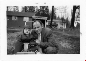
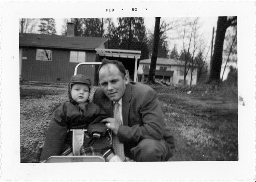
Cor and Sjouke Hiemstra in front of house
https://search.heritageburnaby.ca/link/museumdescription19128
- Repository
- Burnaby Village Museum
- Date
- Feb. 1960
- Collection/Fonds
- Cornelius and Lucy Hiemstra family fonds
- Description Level
- Item
- Physical Description
- 1 photograph : b&w ; 9.5 x 13.5 cm
- Scope and Content
- Photograph of Cornelius "Cor" Hiemstra with his eldest child Sjouke Hiemstra. Sjouke Hiemstra is in a stroller with his father crouched next to him, on the lawn in front of their house located at 5636 Canada Way.
- Repository
- Burnaby Village Museum
- Collection/Fonds
- Cornelius and Lucy Hiemstra family fonds
- Description Level
- Item
- Physical Description
- 1 photograph : b&w ; 9.5 x 13.5 cm
- Scope and Content
- Photograph of Cornelius "Cor" Hiemstra with his eldest child Sjouke Hiemstra. Sjouke Hiemstra is in a stroller with his father crouched next to him, on the lawn in front of their house located at 5636 Canada Way.
- Geographic Access
- Canada Way
- Accession Code
- BV022.15.8
- Access Restriction
- No restrictions
- Reproduction Restriction
- May be restricted by third party rights
- Date
- Feb. 1960
- Media Type
- Photograph
- Historic Neighbourhood
- Burnaby Lake (Historic Neighbourhood)
- Planning Study Area
- Burnaby Lake Area
- Notes
- Title based on contents of photograph
- Date stamp on recto of photograph reads: "FEB_60"
- Stamp in red ink on verso of photograph reads: "A "PICTURE PRINT" / MADE BY / VANCOUVER PHOTOFINISHING CO."
Images
![Kincaid house, [196-] (date of original), copied 1995 thumbnail](/media/Hpo/_Data/_Archives_Images/_Unrestricted/316/324-001.jpg?width=280)
Kincaid house
https://search.heritageburnaby.ca/link/archivedescription37124
- Repository
- City of Burnaby Archives
- Date
- [196-] (date of original), copied 1995
- Collection/Fonds
- Burnaby Historical Society fonds
- Description Level
- Item
- Physical Description
- 1 photograph : b&w ; 8.5 x 12.5 cm print
- Scope and Content
- Photograph of three members of the Kincaid family standing outside of the Kincaid house on Glencarin Drive.
- Repository
- City of Burnaby Archives
- Date
- [196-] (date of original), copied 1995
- Collection/Fonds
- Burnaby Historical Society fonds
- Subseries
- Photographs subseries
- Physical Description
- 1 photograph : b&w ; 8.5 x 12.5 cm print
- Description Level
- Item
- Record No.
- 324-001
- Access Restriction
- No restrictions
- Reproduction Restriction
- Reproduce for fair dealing purposes only
- Accession Number
- BHS1995-18
- Scope and Content
- Photograph of three members of the Kincaid family standing outside of the Kincaid house on Glencarin Drive.
- Subjects
- Buildings - Residential - Houses
- Media Type
- Photograph
- Notes
- Title based on contents of photograph
- Geographic Access
- Glencarin Drive
- Historic Neighbourhood
- Burnaby Lake (Historic Neighbourhood)
- Planning Study Area
- Burnaby Lake Area
Images
![Kincaid house, [196-] (date of original), copied 1995 thumbnail](/media/Hpo/_Data/_Archives_Images/_Unrestricted/316/324-001.jpg)

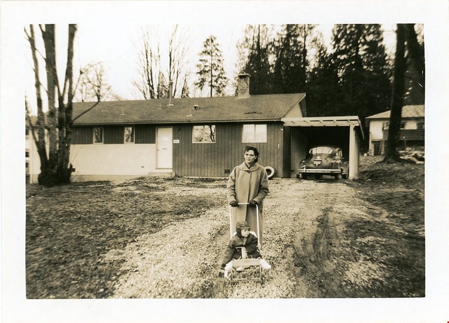
Lucy and Sjouke Hiemstra in front of house
https://search.heritageburnaby.ca/link/museumdescription19127
- Repository
- Burnaby Village Museum
- Date
- Feb. 1960
- Collection/Fonds
- Cornelius and Lucy Hiemstra family fonds
- Description Level
- Item
- Physical Description
- 1 photograph : b&w ; 8.5 x 11.5 cm
- Scope and Content
- Photograph of Lucy Hiemstra pushing her eldest child Sjouke Hiemstra in a stroller on the grass in front of their house located at 5636 Canada Way.
- Repository
- Burnaby Village Museum
- Collection/Fonds
- Cornelius and Lucy Hiemstra family fonds
- Description Level
- Item
- Physical Description
- 1 photograph : b&w ; 8.5 x 11.5 cm
- Scope and Content
- Photograph of Lucy Hiemstra pushing her eldest child Sjouke Hiemstra in a stroller on the grass in front of their house located at 5636 Canada Way.
- Geographic Access
- Canada Way
- Accession Code
- BV022.15.7
- Access Restriction
- No restrictions
- Reproduction Restriction
- May be restricted by third party rights
- Date
- Feb. 1960
- Media Type
- Photograph
- Historic Neighbourhood
- Burnaby Lake (Historic Neighbourhood)
- Planning Study Area
- Burnaby Lake Area
- Notes
- Title based on contents of photograph
- note in blue ink on verso of photograph reads: "Feb. 1960 / Sg. C. Hiemstra Jr."
- Stamp on verso of photograph reads: "919A"
Images
![North side of Burnaby Lake, January 1962 (date of original), copied [1985] thumbnail](/media/hpo/_Data/_BVM_Images/1985/1985_0457_0001_001.jpg?width=280)
North side of Burnaby Lake
https://search.heritageburnaby.ca/link/museumdescription10582
- Repository
- Burnaby Village Museum
- Date
- January 1962 (date of original), copied [1985]
- Collection/Fonds
- Burnaby Village Museum Photograph Collection
- Description Level
- Item
- Physical Description
- 1 photograph : b&w copy negative ; 10 x 12.5 cm
- Scope and Content
- Photograph of the north side of Burnaby Lake January 1962. Preparation for 36 water main crossing at Piper Avenue. The lake and ground are covered with snow.
- Repository
- Burnaby Village Museum
- Collection/Fonds
- Burnaby Village Museum Photograph Collection
- Description Level
- Item
- Physical Description
- 1 photograph : b&w copy negative ; 10 x 12.5 cm
- Scope and Content
- Photograph of the north side of Burnaby Lake January 1962. Preparation for 36 water main crossing at Piper Avenue. The lake and ground are covered with snow.
- Accession Code
- BV985.457.1
- Access Restriction
- No restrictions
- Reproduction Restriction
- May be restricted by third party rights
- Date
- January 1962 (date of original), copied [1985]
- Media Type
- Photograph
- Historic Neighbourhood
- Burnaby Lake (Historic Neighbourhood)
- Planning Study Area
- Burnaby Lake Area
- Scan Resolution
- 1200
- Scan Date
- 2022-06-07
- Photographer
- Lindsay, Jack
- Notes
- Title based on contents of photograph
- Photo by Jack Lindsay Ltd. Photographers, Vancouver. #D28833
Images
![North side of Burnaby Lake, January 1962 (date of original), copied [1985] thumbnail](/media/hpo/_Data/_BVM_Images/1985/1985_0457_0001_001.jpg)
![Tea at the Kincaid house, [196-] (date of original), copied 1995 thumbnail](/media/Hpo/_Data/_Archives_Images/_Unrestricted/316/324-002.jpg?width=280)
Tea at the Kincaid house
https://search.heritageburnaby.ca/link/archivedescription37125
- Repository
- City of Burnaby Archives
- Date
- [196-] (date of original), copied 1995
- Collection/Fonds
- Burnaby Historical Society fonds
- Description Level
- Item
- Physical Description
- 1 photograph : b&w ; 8.5 x 12.5 cm print
- Scope and Content
- Photograph of three people sitting outside on lawn chairs having tea together at the Kincaid house on Glencarin Drive. There is a dog and a tricycle on the lawn.
- Repository
- City of Burnaby Archives
- Date
- [196-] (date of original), copied 1995
- Collection/Fonds
- Burnaby Historical Society fonds
- Subseries
- Photographs subseries
- Physical Description
- 1 photograph : b&w ; 8.5 x 12.5 cm print
- Description Level
- Item
- Record No.
- 324-002
- Access Restriction
- No restrictions
- Reproduction Restriction
- Reproduce for fair dealing purposes only
- Accession Number
- BHS1995-18
- Scope and Content
- Photograph of three people sitting outside on lawn chairs having tea together at the Kincaid house on Glencarin Drive. There is a dog and a tricycle on the lawn.
- Media Type
- Photograph
- Notes
- Title based on contents of photograph
- Geographic Access
- Glencarin Drive
- Historic Neighbourhood
- Burnaby Lake (Historic Neighbourhood)
- Planning Study Area
- Burnaby Lake Area
Images
![Tea at the Kincaid house, [196-] (date of original), copied 1995 thumbnail](/media/Hpo/_Data/_Archives_Images/_Unrestricted/316/324-002.jpg)
![Tea at the Kincaid house, [196-] (date of original), copied 1995 thumbnail](/media/Hpo/_Data/_Archives_Images/_Unrestricted/316/324-003.jpg?width=280)
Tea at the Kincaid house
https://search.heritageburnaby.ca/link/archivedescription37126
- Repository
- City of Burnaby Archives
- Date
- [196-] (date of original), copied 1995
- Collection/Fonds
- Burnaby Historical Society fonds
- Description Level
- Item
- Physical Description
- 1 photograph : b&w ; 8.5 x 12.5 cm print
- Scope and Content
- Photograph of three people sitting outside on lawn chairs having tea together at the Kincaid house on Glencarin Drive.
- Repository
- City of Burnaby Archives
- Date
- [196-] (date of original), copied 1995
- Collection/Fonds
- Burnaby Historical Society fonds
- Subseries
- Photographs subseries
- Physical Description
- 1 photograph : b&w ; 8.5 x 12.5 cm print
- Description Level
- Item
- Record No.
- 324-003
- Access Restriction
- No restrictions
- Reproduction Restriction
- Reproduce for fair dealing purposes only
- Accession Number
- BHS1995-18
- Scope and Content
- Photograph of three people sitting outside on lawn chairs having tea together at the Kincaid house on Glencarin Drive.
- Subjects
- Buildings - Residential - Houses
- Media Type
- Photograph
- Notes
- Title based on contents of photograph
- Geographic Access
- Glencarin Drive
- Historic Neighbourhood
- Burnaby Lake (Historic Neighbourhood)
- Planning Study Area
- Burnaby Lake Area
Images
![Tea at the Kincaid house, [196-] (date of original), copied 1995 thumbnail](/media/Hpo/_Data/_Archives_Images/_Unrestricted/316/324-003.jpg)