Narrow Results By

Bob and Robert Peers at Burnaby Lake
https://search.heritageburnaby.ca/link/archivedescription38940
- Repository
- City of Burnaby Archives
- Date
- 1927
- Collection/Fonds
- Peers Family and Hill Family fonds
- Description Level
- Item
- Physical Description
- 1 photograph : sepia ; 6 x 10.5 cm on page 13.5 x 18.5 cm (pasted in album)
- Scope and Content
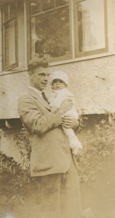
- Photograph of Bob Peers and his son, Robert outside a home identified by a caption as being at "Burnaby Lake." This likely refers to the Bob and Kitty Peers home in the Burnaby Lake area, on Deer Lake Avenue.
- Repository
- City of Burnaby Archives
- Date
- 1927
- Collection/Fonds
- Peers Family and Hill Family fonds
- Physical Description
- 1 photograph : sepia ; 6 x 10.5 cm on page 13.5 x 18.5 cm (pasted in album)
- Description Level
- Item
- Record No.
- 477-259
- Access Restriction
- No restrictions
- Reproduction Restriction
- No known restrictions
- Accession Number
- 2007-12
- Scope and Content
- Photograph of Bob Peers and his son, Robert outside a home identified by a caption as being at "Burnaby Lake." This likely refers to the Bob and Kitty Peers home in the Burnaby Lake area, on Deer Lake Avenue.
- Media Type
- Photograph
- Notes
- Title based on caption accompanying photograph
- Geographic Access
- Deer Lake Avenue
- Street Address
- 6588 Deer Lake Avenue
- Historic Neighbourhood
- Burnaby Lake (Historic Neighbourhood)
- Planning Study Area
- Douglas-Gilpin Area
Images
Claude and Annie Hill's house
https://search.heritageburnaby.ca/link/archivedescription39222
- Repository
- City of Burnaby Archives
- Date
- 1923
- Collection/Fonds
- Peers Family and Hill Family fonds
- Description Level
- Item
- Physical Description
- 1 photograph : sepia ; 6.7 x 10.3 cm on page 24.5 x 32.5 cm (pasted in album)
- Scope and Content
- Photograph of Claude and Annie Hill's house. This was the third home the Hill's lived in that was in the Burnaby Lake area, the first two being known as Brookfield and Broadview.
- Repository
- City of Burnaby Archives
- Date
- 1923
- Collection/Fonds
- Peers Family and Hill Family fonds
- Physical Description
- 1 photograph : sepia ; 6.7 x 10.3 cm on page 24.5 x 32.5 cm (pasted in album)
- Description Level
- Item
- Record No.
- 477-541
- Access Restriction
- No restrictions
- Reproduction Restriction
- No known restrictions
- Accession Number
- 2007-12
- Scope and Content
- Photograph of Claude and Annie Hill's house. This was the third home the Hill's lived in that was in the Burnaby Lake area, the first two being known as Brookfield and Broadview.
- Subjects
- Buildings - Residential - Houses
- Media Type
- Photograph
- Notes
- Title based on caption accompanying photograph
- Geographic Access
- Deer Lake Avenue
- Street Address
- 6570 Deer Lake Avenue
- Historic Neighbourhood
- Burnaby Lake (Historic Neighbourhood)
- Planning Study Area
- Douglas-Gilpin Area
Images

Kitty and Robert
https://search.heritageburnaby.ca/link/archivedescription38946
- Repository
- City of Burnaby Archives
- Date
- December 1927
- Collection/Fonds
- Peers Family and Hill Family fonds
- Description Level
- Item
- Physical Description
- 1 photograph : b&w ; 6 x 10.5 cm on page 13.5 x 18.5 cm (pasted in album)
- Scope and Content
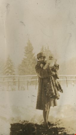
- Photograph of Kitty Peers holding her son Robert, aged nine months. This photograph was taken in December, 1927 in the Burnaby Lake area - note the snow on the ground.
- Repository
- City of Burnaby Archives
- Date
- December 1927
- Collection/Fonds
- Peers Family and Hill Family fonds
- Physical Description
- 1 photograph : b&w ; 6 x 10.5 cm on page 13.5 x 18.5 cm (pasted in album)
- Description Level
- Item
- Record No.
- 477-265
- Access Restriction
- No restrictions
- Reproduction Restriction
- No known restrictions
- Accession Number
- 2007-12
- Scope and Content
- Photograph of Kitty Peers holding her son Robert, aged nine months. This photograph was taken in December, 1927 in the Burnaby Lake area - note the snow on the ground.
- Media Type
- Photograph
- Notes
- Title based on caption accompanying photograph
- Historic Neighbourhood
- Burnaby Lake (Historic Neighbourhood)
- Planning Study Area
- Morley-Buckingham Area
Images
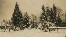
Trees and in the snow
https://search.heritageburnaby.ca/link/archivedescription39308
- Repository
- City of Burnaby Archives
- Date
- 1922
- Collection/Fonds
- Peers Family and Hill Family fonds
- Description Level
- Item
- Physical Description
- 1 photograph : b&w ; 6 x 10.4 cm on page 24.5 x 32.5 cm (pasted in album)
- Scope and Content
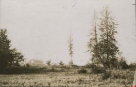
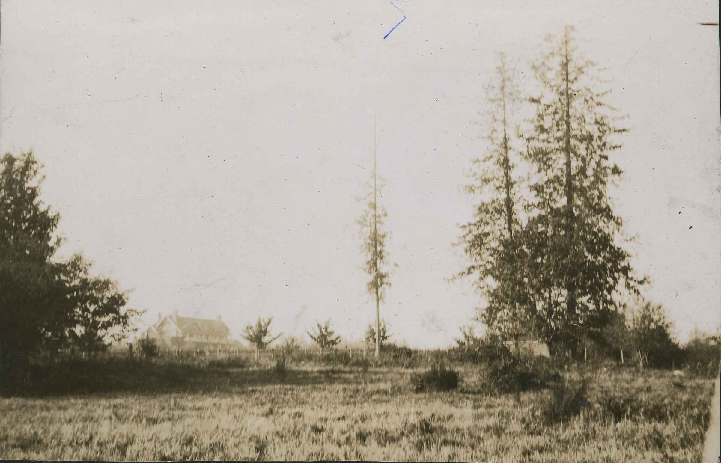
- Photograph of a field and trees covered in snow. This photograph was probably taken at Broadview, the home of Claude Hill and his family in the Burnaby Lake area.
- Repository
- City of Burnaby Archives
- Date
- 1922
- Collection/Fonds
- Peers Family and Hill Family fonds
- Physical Description
- 1 photograph : b&w ; 6 x 10.4 cm on page 24.5 x 32.5 cm (pasted in album)
- Description Level
- Item
- Record No.
- 477-627
- Access Restriction
- No restrictions
- Reproduction Restriction
- No known restrictions
- Accession Number
- 2007-12
- Scope and Content
- Photograph of a field and trees covered in snow. This photograph was probably taken at Broadview, the home of Claude Hill and his family in the Burnaby Lake area.
- Subjects
- Natural Phenomena - Snow
- Plants - Trees
- Media Type
- Photograph
- Notes
- Title based on contents of photograph
- Geographic Access
- Buckingham Avenue
- Street Address
- 5730 Buckingham Avenue
- Historic Neighbourhood
- Burnaby Lake (Historic Neighbourhood)
- Planning Study Area
- Morley-Buckingham Area
Images


Burnaby Lake
https://search.heritageburnaby.ca/link/archivedescription34563
- Repository
- City of Burnaby Archives
- Date
- 1923
- Collection/Fonds
- Burnaby Historical Society fonds
- Description Level
- Item
- Physical Description
- 1 photograph : b&w ; 17.4 x 35.3 cm
- Scope and Content
- Photograph of Burnaby Lake, looking northwest. The north shore mountains, including The Lions, can be seen in the background.
- Repository
- City of Burnaby Archives
- Date
- 1923
- Collection/Fonds
- Burnaby Historical Society fonds
- Subseries
- Photographs subseries
- Physical Description
- 1 photograph : b&w ; 17.4 x 35.3 cm
- Description Level
- Item
- Record No.
- 050-001
- Access Restriction
- No restrictions
- Reproduction Restriction
- No known restrictions
- Accession Number
- BHS2007-04
- Scope and Content
- Photograph of Burnaby Lake, looking northwest. The north shore mountains, including The Lions, can be seen in the background.
- Media Type
- Photograph
- Notes
- Title based on contents of photograph
- Geographic Access
- Burnaby Lake
- Historic Neighbourhood
- Burnaby Lake (Historic Neighbourhood)
- Planning Study Area
- Burnaby Lake Area
Images

![Map of proposed provincial exhibition site at Burnaby Lake, [between 1929 and 1931] thumbnail](/media/hpo/_Data/_BVM_Cartographic_Material/2017/2017_0002_0009_005.jpg?width=280)
Map of proposed provincial exhibition site at Burnaby Lake
https://search.heritageburnaby.ca/link/museumdescription8703
- Repository
- Burnaby Village Museum
- Date
- [between 1929 and 1931]
- Collection/Fonds
- Burnaby Village Museum Map collection
- Description Level
- Item
- Physical Description
- 1 map : photostat print ; 3 parts 45 x 33.7 cm totalling 45 x 101 cm
- Scope and Content
- Item consists of a tri-part folding map of a proposed Provincial Exhibition site located along the southern and western shore of Burnaby Lake. Exhibtion site on map identifies proposed locations for a golf course, pier, hydroplane landing ramp, sports ground, one-mile horse racing track and various…
- Repository
- Burnaby Village Museum
- Collection/Fonds
- Burnaby Village Museum Map collection
- Description Level
- Item
- Physical Description
- 1 map : photostat print ; 3 parts 45 x 33.7 cm totalling 45 x 101 cm
- Material Details
- Scale [1:1800]
- Scope and Content
- Item consists of a tri-part folding map of a proposed Provincial Exhibition site located along the southern and western shore of Burnaby Lake. Exhibtion site on map identifies proposed locations for a golf course, pier, hydroplane landing ramp, sports ground, one-mile horse racing track and various buildings for mechanical, agricultural and botanical displays.
- Subjects
- Exhibitions
- Accession Code
- BV017.2.9
- Access Restriction
- No restrictions
- Reproduction Restriction
- No known restrictions
- Date
- [between 1929 and 1931]
- Media Type
- Cartographic Material
- Historic Neighbourhood
- Burnaby Lake (Historic Neighbourhood)
- Planning Study Area
- Burnaby Lake Area
- Scan Resolution
- 400
- Scan Date
- 2021-11-18
- Notes
- Title based on contents of map
- Scale on map reads: "150 feet to 1 inch"
- Overall measurements when fully opened: L: 98.0 cm x H: 45.3 cm ; Individual map parts: L: 32.7 cm x H: 45.0 cm
- Commercially printed label on front of portfolio card reads "PLOWRIGHT PRINTING COMPANY / TELEPHONE N.W. 1942 / 39 McKENZIE STREET NEW WESTMINSTER, B.C. / TO: [illegible writing in pencil]" in blue ink. Red typewritten text reads: "PHOTOSTAT OF BURNABY LAKE".
Images
![Map of proposed provincial exhibition site at Burnaby Lake, [between 1929 and 1931] thumbnail](/media/hpo/_Data/_BVM_Cartographic_Material/2017/2017_0002_0009_005.jpg)


![Old Brunette Dam, [1925] (date of original), copied 1986 thumbnail](/media/hpo/_Data/_Archives_Images/_Unrestricted/204/204-324.jpg?width=280)
Old Brunette Dam
https://search.heritageburnaby.ca/link/archivedescription35466
- Repository
- City of Burnaby Archives
- Date
- [1925] (date of original), copied 1986
- Collection/Fonds
- Burnaby Historical Society fonds
- Description Level
- Item
- Physical Description
- 1 photograph : b&w ; 12.7 x 17.8 cm print
- Scope and Content
- Photograph of the old Brunette dam before 1931. Shown on the left, the spillway allowed spawning salmon to wriggle over into spawning grounds in Eagle Creek and Still Creek.
- Repository
- City of Burnaby Archives
- Date
- [1925] (date of original), copied 1986
- Collection/Fonds
- Burnaby Historical Society fonds
- Subseries
- Pioneer Tales subseries
- Physical Description
- 1 photograph : b&w ; 12.7 x 17.8 cm print
- Description Level
- Item
- Record No.
- 204-324
- Access Restriction
- No restrictions
- Reproduction Restriction
- No known restrictions
- Accession Number
- BHS1988-03
- Scope and Content
- Photograph of the old Brunette dam before 1931. Shown on the left, the spillway allowed spawning salmon to wriggle over into spawning grounds in Eagle Creek and Still Creek.
- Media Type
- Photograph
- Notes
- Title based on contents of photograph
- Historic Neighbourhood
- Burquitlam (Historic Neighbourhood)
- Planning Study Area
- Burnaby Lake Area
Images
![Old Brunette Dam, [1925] (date of original), copied 1986 thumbnail](/media/hpo/_Data/_Archives_Images/_Unrestricted/204/204-324.jpg)
![Old Brunette River Dam, [1920] thumbnail](/media/hpo/_Data/_Archives_Images/_Unrestricted/205/232-002.jpg?width=280)
Old Brunette River Dam
https://search.heritageburnaby.ca/link/archivedescription36205
- Repository
- City of Burnaby Archives
- Date
- [1920]
- Collection/Fonds
- Burnaby Historical Society fonds
- Description Level
- Item
- Physical Description
- 1 photograph : b&w ; 8.5 x 12.5 cm print
- Scope and Content
- Photograph of a group of six men and their five dogs at the Old Brunette River Dam. The men are in suits and most are wearing bowler hats. Their dogs look to be English Foxhounds and Poodles.
- Repository
- City of Burnaby Archives
- Date
- [1920]
- Collection/Fonds
- Burnaby Historical Society fonds
- Subseries
- Love family subseries
- Physical Description
- 1 photograph : b&w ; 8.5 x 12.5 cm print
- Description Level
- Item
- Record No.
- 232-002
- Access Restriction
- No restrictions
- Reproduction Restriction
- No known restrictions
- Accession Number
- BHS1989-24
- Scope and Content
- Photograph of a group of six men and their five dogs at the Old Brunette River Dam. The men are in suits and most are wearing bowler hats. Their dogs look to be English Foxhounds and Poodles.
- Media Type
- Photograph
- Notes
- Title based on contents of photograph
- 1 b&w copy negative accompanying
- Geographic Access
- Brunette River
- Historic Neighbourhood
- Burquitlam (Historic Neighbourhood)
- Planning Study Area
- Burnaby Lake Area
Images
![Old Brunette River Dam, [1920] thumbnail](/media/hpo/_Data/_Archives_Images/_Unrestricted/205/232-002.jpg)