
Ardingley-Sprott Neighbourhood
https://search.heritageburnaby.ca/link/landmark797
- Repository
- Burnaby Heritage Planning
- Associated Dates
- 1955-2008
- Heritage Value
- The Ardingley-Sprott Neighbourhood is primarily non-residential and developed in the 1970s west of the Burnaby Lake park area. It grew to include a large recreational component in the form of the Burnaby Lake Sports Complex and playing fields.
- Historic Neighbourhood
- Burnaby Lake (Historic Neighbourhood)
- Planning Study Area
- Ardingley-Sprott Area
Images


Douglas-Gilpin Neighbourhood
https://search.heritageburnaby.ca/link/landmark799
- Repository
- Burnaby Heritage Planning
- Associated Dates
- 1955-2008
- Heritage Value
- The Douglas-Gilpin Neighbourhood developed into a diverse area incorporating residential, business, educational and park districts in the period after 1955. The BCIT site was built in the early 1960s, shortly after the Burnaby Municipal Hall was located on Canada Way near Deer Lake in 1956. The construction of the Municipal Hall at this location fostered the creation of an administrative and business centre adjacent to the park, while the northern and central areas of the neighbourhood retained their primarily residential character.
- Historic Neighbourhood
- Burnaby Lake (Historic Neighbourhood)
- Planning Study Area
- Douglas-Gilpin Area
Images


Burnaby Village Museum
https://search.heritageburnaby.ca/link/landmark808
- Repository
- Burnaby Heritage Planning
- Geographic Access
- Deer Lake Avenue
- Associated Dates
- 1971
- Heritage Value
- The Burnaby Village Museum is a ten-acre heritage site located adjacent to Deer Lake. The site was originally created as a B.C. Centennial Project in 1971. The official sod turning for was April 11, 1971 by the then Governor General of Canada Roland Mitchener. The Village was initially managed by the Century Park Museum Association, a volunteer society of Burnaby citizens. Over the years many heritage building which could not be maintained in their original locations have been moved to the museum. Today half of the buildings in the village are heritage structures and the remainder are reproductions. In 1990 the City of Burnaby assumed direct management of the Village, and the museum became part of the Parks, Recreation and Culture Department. Visitors can enjoy the shops on Hill Street, ride the Parker 119 Carousel, and climb aboard the Interurban 1223 tram.
- Historic Neighbourhood
- Burnaby Lake (Historic Neighbourhood)
- Planning Study Area
- Douglas-Gilpin Area
- Morley-Buckingham Area
- Street Address
- 6501 Deer Lake Avenue
- Street View URL
- Google Maps Street View
Images


Burnaby Lake Neighbourhood
https://search.heritageburnaby.ca/link/landmark821
- Repository
- Burnaby Heritage Planning
- Associated Dates
- 1955-2008
- Heritage Value
- In 1966 Burnaby Lake was identified as a key potential regional park in the GVRD ’s Regional Park Plan for the Lower Mainland. The lake was to be developed for nature study, strolling, trail riding, canoeing, sightseeing and picnicking. It was formally recognized as a regional nature park in 1979, at which time the GVRD assumed management of the park through a lease agreement with the City of Burnaby. In 1993 Burnaby Lake was selected by the City of Burnaby to be included in Greater Vancouver ’s Green Zone, and was identified as a key component of the GVRD ’s Park and Outdoor Recreation System (PORS) for the Burrard/Peninsula/Richmond sector, which includes Burnaby, Vancouver, New Westminster, and Richmond.
- Historic Neighbourhood
- Burnaby Lake (Historic Neighbourhood)
- Planning Study Area
- Burnaby Lake Area
Images


Morley-Buckingham Neighbourhood
https://search.heritageburnaby.ca/link/landmark829
- Repository
- Burnaby Heritage Planning
- Associated Dates
- 1955-2008
- Heritage Value
- In the 1980 "Residential Neighbourhood Environment Study," the Morley-Buckingham Neighbourhood is described as "perhaps Burnaby's most prestigious residential area. The lots are larger than most other areas of the Municipality and this, along with the new expensive housing developed over the past 10 years, has created a very desirable residential neighbourhood...The older area of Buckingham lies at the lower edge of the slope and here the homes and streets are more uniform and aged between 20 and 25 years old...to the east of Canada Way lies...a cluster townhouse development."
- Historic Neighbourhood
- Burnaby Lake (Historic Neighbourhood)
- Planning Study Area
- Morley-Buckingham Area
Images

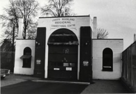
Lower Mainland Regional Correctional Centre - Main Gate
https://search.heritageburnaby.ca/link/archivedescription79991
- Repository
- City of Burnaby Archives
- Date
- December 3, 1976
- Collection/Fonds
- Burnaby Public Library Contemporary Visual Archive Project
- Description Level
- Item
- Physical Description
- 1 photograph : b&w ; 11 x 16 cm mounted on cardboard
- Scope and Content
- Photograph shows the main gate of the Lower Mainland Regional Correctional Centre at 4700 Royal Oak Avenue (later 5220 Oakmount Crescent). The Centre, commonly called Oakalla, was built around 1911.
- Repository
- City of Burnaby Archives
- Date
- December 3, 1976
- Collection/Fonds
- Burnaby Public Library Contemporary Visual Archive Project
- Physical Description
- 1 photograph : b&w ; 11 x 16 cm mounted on cardboard
- Description Level
- Item
- Record No.
- 556-547
- Access Restriction
- No restrictions
- Reproduction Restriction
- Reproduce for fair dealing purposes only
- Accession Number
- 2013-13
- Scope and Content
- Photograph shows the main gate of the Lower Mainland Regional Correctional Centre at 4700 Royal Oak Avenue (later 5220 Oakmount Crescent). The Centre, commonly called Oakalla, was built around 1911.
- Media Type
- Photograph
- Photographer
- Norton, Paul
- Notes
- Scope note taken directly from BPL photograph description.
- 1 b&w copy negative : 10 x 12.5 cm accompanying
- Geographic Access
- Oakmount Crescent
- Royal Oak Avenue
- Street Address
- 5220 Oakmount Crescent
- 4700 Royal Oak Avenue
- Historic Neighbourhood
- Burnaby Lake (Historic Neighbourhood)
- Planning Study Area
- Oakalla Area
Images

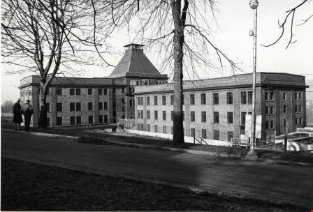
Lower Mainland Regional Correctional Centre - Main Block
https://search.heritageburnaby.ca/link/archivedescription80010
- Repository
- City of Burnaby Archives
- Date
- December 3, 1976
- Collection/Fonds
- Burnaby Public Library Contemporary Visual Archive Project
- Description Level
- Item
- Physical Description
- 1 photograph : b&w ; 11 x 16 cm mounted on cardboard
- Scope and Content
- Photograph shows the main block of the Lower Mainland Regional Correctional Centre.
- Repository
- City of Burnaby Archives
- Date
- December 3, 1976
- Collection/Fonds
- Burnaby Public Library Contemporary Visual Archive Project
- Physical Description
- 1 photograph : b&w ; 11 x 16 cm mounted on cardboard
- Description Level
- Item
- Record No.
- 556-548
- Access Restriction
- No restrictions
- Reproduction Restriction
- Reproduce for fair dealing purposes only
- Accession Number
- 2013-13
- Scope and Content
- Photograph shows the main block of the Lower Mainland Regional Correctional Centre.
- Media Type
- Photograph
- Photographer
- Norton, Paul
- Notes
- Scope note taken directly from BPL photograph description.
- 1 b&w copy negative : 10 x 12.5 cm accompanying
- Geographic Access
- Oakmount Crescent
- Royal Oak Avenue
- Street Address
- 5220 Oakmount Crescent
- 4700 Royal Oak Avenue
- Historic Neighbourhood
- Burnaby Lake (Historic Neighbourhood)
- Planning Study Area
- Oakalla Area
Images


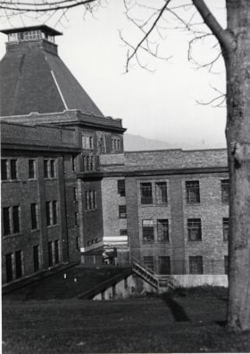
Lower Mainland Regional Correctional Centre - Main Block
https://search.heritageburnaby.ca/link/archivedescription80011
- Repository
- City of Burnaby Archives
- Date
- December 3, 1976
- Collection/Fonds
- Burnaby Public Library Contemporary Visual Archive Project
- Description Level
- Item
- Physical Description
- 1 photograph : b&w ; 11 x 16 cm mounted on cardboard
- Scope and Content
- Photograph shows the main block of the Lower Mainland Regional Correctional Centre.
- Repository
- City of Burnaby Archives
- Date
- December 3, 1976
- Collection/Fonds
- Burnaby Public Library Contemporary Visual Archive Project
- Physical Description
- 1 photograph : b&w ; 11 x 16 cm mounted on cardboard
- Description Level
- Item
- Record No.
- 556-549
- Access Restriction
- No restrictions
- Reproduction Restriction
- Reproduce for fair dealing purposes only
- Accession Number
- 2013-13
- Scope and Content
- Photograph shows the main block of the Lower Mainland Regional Correctional Centre.
- Media Type
- Photograph
- Photographer
- Norton, Paul
- Notes
- Scope note taken directly from BPL photograph description.
- 1 b&w copy negative : 10 x 12.5 cm accompanying
- Geographic Access
- Oakmount Crescent
- Royal Oak Avenue
- Street Address
- 5220 Oakmount Crescent
- 4700 Royal Oak Avenue
- Historic Neighbourhood
- Burnaby Lake (Historic Neighbourhood)
- Planning Study Area
- Oakalla Area
Images
Lower Mainland Regional Correctional Centre - Main Block
https://search.heritageburnaby.ca/link/archivedescription80012
- Repository
- City of Burnaby Archives
- Date
- December 3, 1976
- Collection/Fonds
- Burnaby Public Library Contemporary Visual Archive Project
- Description Level
- Item
- Physical Description
- 1 photograph : b&w ; 11 x 16 cm mounted on cardboard
- Scope and Content
- Photograph shows the main block of the Lower Mainland Regional Correctional Centre.
- Repository
- City of Burnaby Archives
- Date
- December 3, 1976
- Collection/Fonds
- Burnaby Public Library Contemporary Visual Archive Project
- Physical Description
- 1 photograph : b&w ; 11 x 16 cm mounted on cardboard
- Description Level
- Item
- Record No.
- 556-550
- Access Restriction
- No restrictions
- Reproduction Restriction
- Reproduce for fair dealing purposes only
- Accession Number
- 2013-13
- Scope and Content
- Photograph shows the main block of the Lower Mainland Regional Correctional Centre.
- Media Type
- Photograph
- Photographer
- Norton, Paul
- Notes
- Scope note taken directly from BPL photograph description.
- 1 b&w copy negative : 10 x 12.5 cm accompanying
- Geographic Access
- Oakmount Crescent
- Royal Oak Avenue
- Street Address
- 5220 Oakmount Crescent
- 4700 Royal Oak Avenue
- Historic Neighbourhood
- Burnaby Lake (Historic Neighbourhood)
- Planning Study Area
- Oakalla Area
Images


Lower Mainland Regional Correctional Centre - Main Block
https://search.heritageburnaby.ca/link/archivedescription80013
- Repository
- City of Burnaby Archives
- Date
- December 3, 1976
- Collection/Fonds
- Burnaby Public Library Contemporary Visual Archive Project
- Description Level
- Item
- Physical Description
- 1 photograph : b&w ; 11 x 16 cm mounted on cardboard
- Scope and Content
- Photograph shows the main block of the Lower Mainland Regional Correctional Centre.
- Repository
- City of Burnaby Archives
- Date
- December 3, 1976
- Collection/Fonds
- Burnaby Public Library Contemporary Visual Archive Project
- Physical Description
- 1 photograph : b&w ; 11 x 16 cm mounted on cardboard
- Description Level
- Item
- Record No.
- 556-551
- Access Restriction
- No restrictions
- Reproduction Restriction
- Reproduce for fair dealing purposes only
- Accession Number
- 2013-13
- Scope and Content
- Photograph shows the main block of the Lower Mainland Regional Correctional Centre.
- Media Type
- Photograph
- Photographer
- Norton, Paul
- Notes
- Scope note taken directly from BPL photograph description.
- 1 b&w copy negative : 10 x 12.5 cm accompanying
- Geographic Access
- Oakmount Crescent
- Royal Oak Avenue
- Street Address
- 5220 Oakmount Crescent
- 4700 Royal Oak Avenue
- Historic Neighbourhood
- Burnaby Lake (Historic Neighbourhood)
- Planning Study Area
- Oakalla Area
Images

Lower Mainland Regional Correctional Centre - Main Block
https://search.heritageburnaby.ca/link/archivedescription80014
- Repository
- City of Burnaby Archives
- Date
- December 3, 1976
- Collection/Fonds
- Burnaby Public Library Contemporary Visual Archive Project
- Description Level
- Item
- Physical Description
- 1 photograph : b&w ; 11 x 16 cm mounted on cardboard
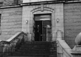
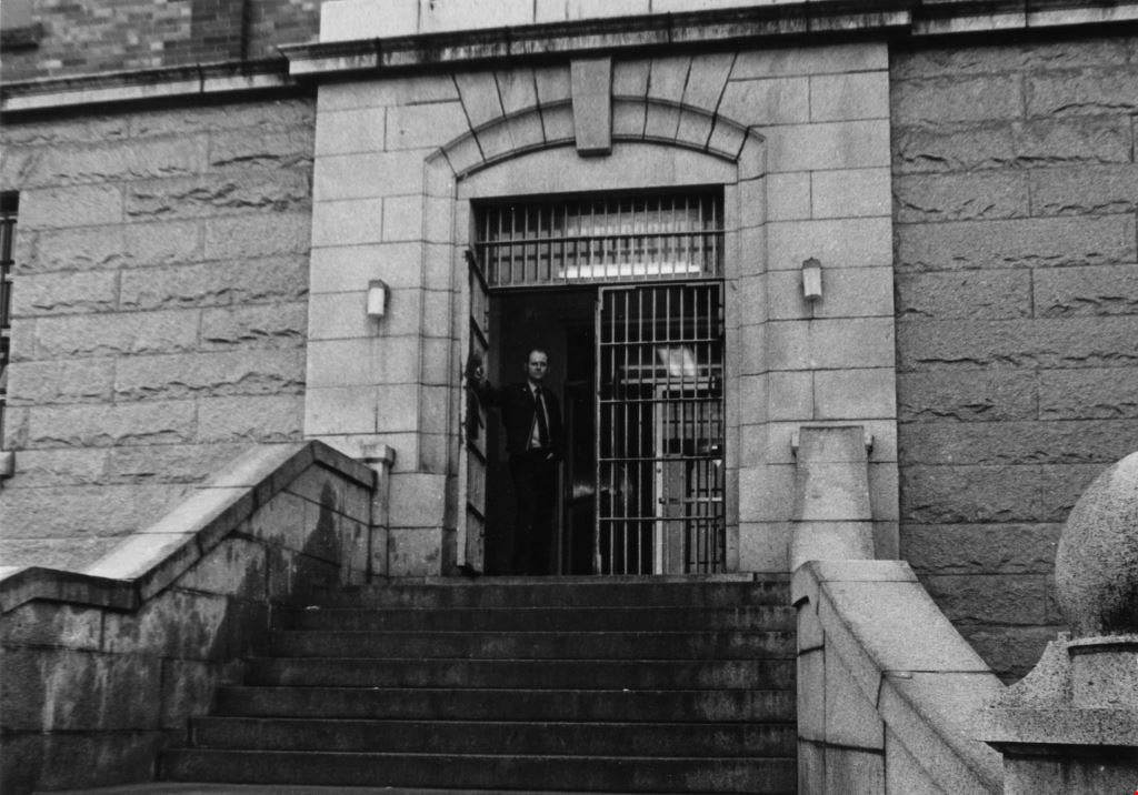
- Scope and Content
- Photograph shows a guard at the front door of the main block of the Lower Mainland Regional Correctional Centre.
- Repository
- City of Burnaby Archives
- Date
- December 3, 1976
- Collection/Fonds
- Burnaby Public Library Contemporary Visual Archive Project
- Physical Description
- 1 photograph : b&w ; 11 x 16 cm mounted on cardboard
- Description Level
- Item
- Record No.
- 556-552
- Access Restriction
- No restrictions
- Reproduction Restriction
- Reproduce for fair dealing purposes only
- Accession Number
- 2013-13
- Scope and Content
- Photograph shows a guard at the front door of the main block of the Lower Mainland Regional Correctional Centre.
- Media Type
- Photograph
- Photographer
- Norton, Paul
- Notes
- Scope note taken directly from BPL photograph description.
- 1 b&w copy negative : 10 x 12.5 cm accompanying
- Geographic Access
- Oakmount Crescent
- Royal Oak Avenue
- Street Address
- 5220 Oakmount Crescent
- 4700 Royal Oak Avenue
- Historic Neighbourhood
- Burnaby Lake (Historic Neighbourhood)
- Planning Study Area
- Oakalla Area
Images
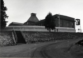
Lower Mainland Regional Correctional Centre - Fence
https://search.heritageburnaby.ca/link/archivedescription80015
- Repository
- City of Burnaby Archives
- Date
- December 3, 1976
- Collection/Fonds
- Burnaby Public Library Contemporary Visual Archive Project
- Description Level
- Item
- Physical Description
- 1 photograph : b&w ; 11 x 16 cm mounted on cardboard
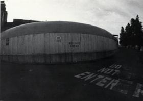
- Scope and Content
- Photograph shows the fence around the exercise yard at the Lower Mainland Regional Correctional Centre.
- Repository
- City of Burnaby Archives
- Date
- December 3, 1976
- Collection/Fonds
- Burnaby Public Library Contemporary Visual Archive Project
- Physical Description
- 1 photograph : b&w ; 11 x 16 cm mounted on cardboard
- Description Level
- Item
- Record No.
- 556-553
- Access Restriction
- No restrictions
- Reproduction Restriction
- Reproduce for fair dealing purposes only
- Accession Number
- 2013-13
- Scope and Content
- Photograph shows the fence around the exercise yard at the Lower Mainland Regional Correctional Centre.
- Media Type
- Photograph
- Photographer
- Norton, Paul
- Notes
- Scope note taken directly from BPL photograph description.
- 1 b&w copy negative : 10 x 12.5 cm accompanying
- Geographic Access
- Oakmount Crescent
- Royal Oak Avenue
- Street Address
- 5220 Oakmount Crescent
- 4700 Royal Oak Avenue
- Historic Neighbourhood
- Burnaby Lake (Historic Neighbourhood)
- Planning Study Area
- Oakalla Area
Images

Lower Mainland Regional Correctional Centre - Playing Field
https://search.heritageburnaby.ca/link/archivedescription80016
- Repository
- City of Burnaby Archives
- Date
- December 3, 1976
- Collection/Fonds
- Burnaby Public Library Contemporary Visual Archive Project
- Description Level
- Item
- Physical Description
- 1 photograph : b&w ; 11 x 16 cm mounted on cardboard
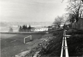
- Scope and Content
- Photograph shows the playing field at the Lower Mainland Regional Correctional Centre.
- Repository
- City of Burnaby Archives
- Date
- December 3, 1976
- Collection/Fonds
- Burnaby Public Library Contemporary Visual Archive Project
- Physical Description
- 1 photograph : b&w ; 11 x 16 cm mounted on cardboard
- Description Level
- Item
- Record No.
- 556-554
- Access Restriction
- No restrictions
- Reproduction Restriction
- Reproduce for fair dealing purposes only
- Accession Number
- 2013-13
- Scope and Content
- Photograph shows the playing field at the Lower Mainland Regional Correctional Centre.
- Media Type
- Photograph
- Photographer
- Norton, Paul
- Notes
- Scope note taken directly from BPL photograph description.
- 1 b&w copy negative : 10 x 12.5 cm accompanying
- Geographic Access
- Oakmount Crescent
- Royal Oak Avenue
- Street Address
- 5220 Oakmount Crescent
- 4700 Royal Oak Avenue
- Historic Neighbourhood
- Burnaby Lake (Historic Neighbourhood)
- Planning Study Area
- Oakalla Area
Images

Lower Mainland Regional Correctional Centre - Grounds
https://search.heritageburnaby.ca/link/archivedescription80017
- Repository
- City of Burnaby Archives
- Date
- December 3, 1976
- Collection/Fonds
- Burnaby Public Library Contemporary Visual Archive Project
- Description Level
- Item
- Physical Description
- 1 photograph : b&w ; 11 x 16 cm mounted on cardboard
- Scope and Content
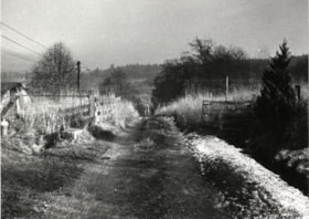
- Photograph shows a lane near the barns on the grounds of the Lower Mainland Regional Correctional Centre.
- Repository
- City of Burnaby Archives
- Date
- December 3, 1976
- Collection/Fonds
- Burnaby Public Library Contemporary Visual Archive Project
- Physical Description
- 1 photograph : b&w ; 11 x 16 cm mounted on cardboard
- Description Level
- Item
- Record No.
- 556-555
- Access Restriction
- No restrictions
- Reproduction Restriction
- Reproduce for fair dealing purposes only
- Accession Number
- 2013-13
- Scope and Content
- Photograph shows a lane near the barns on the grounds of the Lower Mainland Regional Correctional Centre.
- Media Type
- Photograph
- Photographer
- Norton, Paul
- Notes
- Scope note taken directly from BPL photograph description.
- 1 b&w copy negative : 10 x 12.5 cm accompanying
- Geographic Access
- Oakmount Crescent
- Royal Oak Avenue
- Street Address
- 5220 Oakmount Crescent
- 4700 Royal Oak Avenue
- Historic Neighbourhood
- Burnaby Lake (Historic Neighbourhood)
- Planning Study Area
- Oakalla Area
Images


Lower Mainland Regional Correctional Centre - Barns
https://search.heritageburnaby.ca/link/archivedescription80018
- Repository
- City of Burnaby Archives
- Date
- December 3, 1976
- Collection/Fonds
- Burnaby Public Library Contemporary Visual Archive Project
- Description Level
- Item
- Physical Description
- 1 photograph : b&w ; 11 x 16 cm mounted on cardboard
- Scope and Content
- Photograph shows the old barns on the grounds of the Lower Mainland Regional Correctional Centre.
- Repository
- City of Burnaby Archives
- Date
- December 3, 1976
- Collection/Fonds
- Burnaby Public Library Contemporary Visual Archive Project
- Physical Description
- 1 photograph : b&w ; 11 x 16 cm mounted on cardboard
- Description Level
- Item
- Record No.
- 556-556
- Access Restriction
- No restrictions
- Reproduction Restriction
- Reproduce for fair dealing purposes only
- Accession Number
- 2013-13
- Scope and Content
- Photograph shows the old barns on the grounds of the Lower Mainland Regional Correctional Centre.
- Media Type
- Photograph
- Photographer
- Norton, Paul
- Notes
- Scope note taken directly from BPL photograph description.
- 1 b&w copy negative : 10 x 12.5 cm accompanying
- Geographic Access
- Oakmount Crescent
- Royal Oak Avenue
- Street Address
- 5220 Oakmount Crescent
- 4700 Royal Oak Avenue
- Historic Neighbourhood
- Burnaby Lake (Historic Neighbourhood)
- Planning Study Area
- Oakalla Area
Images

Lower Mainland Regional Correctional Centre - House
https://search.heritageburnaby.ca/link/archivedescription80019
- Repository
- City of Burnaby Archives
- Date
- December 3, 1976
- Collection/Fonds
- Burnaby Public Library Contemporary Visual Archive Project
- Description Level
- Item
- Physical Description
- 1 photograph : b&w ; 11 x 16 cm mounted on cardboard
- Scope and Content
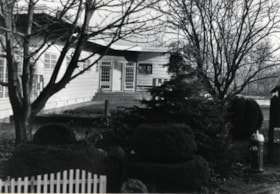
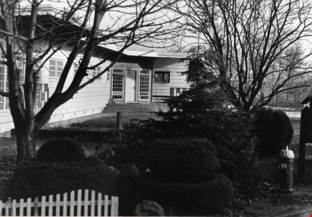
- Photograph shows a house on the grounds of the Lower Mainland Regional Correctional Centre.
- Repository
- City of Burnaby Archives
- Date
- December 3, 1976
- Collection/Fonds
- Burnaby Public Library Contemporary Visual Archive Project
- Physical Description
- 1 photograph : b&w ; 11 x 16 cm mounted on cardboard
- Description Level
- Item
- Record No.
- 556-557
- Access Restriction
- No restrictions
- Reproduction Restriction
- Reproduce for fair dealing purposes only
- Accession Number
- 2013-13
- Scope and Content
- Photograph shows a house on the grounds of the Lower Mainland Regional Correctional Centre.
- Media Type
- Photograph
- Photographer
- Norton, Paul
- Notes
- Scope note taken directly from BPL photograph description.
- 1 b&w copy negative : 10 x 12.5 cm accompanying
- Geographic Access
- Oakmount Crescent
- Royal Oak Avenue
- Street Address
- 5220 Oakmount Crescent
- 4700 Royal Oak Avenue
- Historic Neighbourhood
- Burnaby Lake (Historic Neighbourhood)
- Planning Study Area
- Oakalla Area
Images
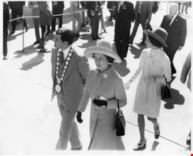
Queen Elizabeth II, Prince Philip and officials during Royal visit to Burnaby Municipal Hall
https://search.heritageburnaby.ca/link/museumdescription1959
- Repository
- Burnaby Village Museum
- Date
- 7 May 1971
- Collection/Fonds
- Donald Copan collection
- Description Level
- Item
- Physical Description
- 1 photograph : b&w ; 12.5 x 18 cm
- Scope and Content
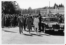
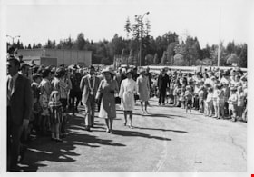
- Photograph of Queen Elizabeth II followed by acting-mayor Hugh Ladner and his wife Valerie Ruth Ladner (in white), Prince Philip, federal Consumer Affairs Minister Ron Basford and his wife, Health Minister Ralph Loffmark, Centennial '71 Committee chair, James Barrington and other dignitaries and at…
- Repository
- Burnaby Village Museum
- Collection/Fonds
- Donald Copan collection
- Series
- Copan album series
- Description Level
- Item
- Physical Description
- 1 photograph : b&w ; 12.5 x 18 cm
- Scope and Content
- Photograph of Queen Elizabeth II followed by acting-mayor Hugh Ladner and his wife Valerie Ruth Ladner (in white), Prince Philip, federal Consumer Affairs Minister Ron Basford and his wife, Health Minister Ralph Loffmark, Centennial '71 Committee chair, James Barrington and other dignitaries and attendants. The Queen visited Burnaby Municipal Hall on May 7, 1971. The group is walking down the road, next to a Rolls Royce while a crowd looks on.
- Names
- Elizabeth II Queen of Great Britain, 1926-2022
- Ladner, Hugh G.
- Philip, Prince, consort of Elizabeth II, Queen of Great Britain, 1921-2021
- Barrington, James Alfred "Jim"
- Ladner, Valerie Ruth Grant
- Geographic Access
- Canada Way
- Street Address
- 4949 Canada Way
- Accession Code
- BV005.54.7
- Access Restriction
- No restrictions
- Reproduction Restriction
- May be restricted by third party rights
- Date
- 7 May 1971
- Media Type
- Photograph
- Historic Neighbourhood
- Burnaby Lake (Historic Neighbourhood)
- Planning Study Area
- Douglas-Gilpin Area
- Scan Resolution
- 600
- Scan Date
- 13-Jul-20
- Scale
- 100
- Notes
- Title based on contents of photograph
- Notes in ink on verso of photograph read: "H.L-1 / DC-1 /O.H-1"
- Note in green pencil reads: "3"
- Verso of photograph includes handwritten intials in black ink
- Photograph was removed from Copan Album page
Images

Queen Elizabeth II and officials during Royal visit to Burnaby Municipal Hall
https://search.heritageburnaby.ca/link/museumdescription1961
- Repository
- Burnaby Village Museum
- Date
- 7 May 1971
- Collection/Fonds
- Donald Copan collection
- Description Level
- Item
- Physical Description
- 1 photograph : b&w ; 12.5 x 18 cm
- Scope and Content
- Photograph of Queen Elizabeth II followed by acting-mayor Hugh Ladner and his wife Valerie Ruth Ladner (in white), Prince Philip, federal Consumer Affairs Minister Ron Basford and his wife, Health Minister Ralph Loffmark, Centennial '71 Committee chair, James Barrington and other dignitaries and a…
- Repository
- Burnaby Village Museum
- Collection/Fonds
- Donald Copan collection
- Series
- Copan album series
- Description Level
- Item
- Physical Description
- 1 photograph : b&w ; 12.5 x 18 cm
- Scope and Content
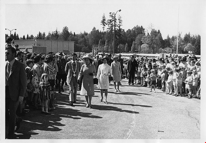
- Photograph of Queen Elizabeth II followed by acting-mayor Hugh Ladner and his wife Valerie Ruth Ladner (in white), Prince Philip, federal Consumer Affairs Minister Ron Basford and his wife, Health Minister Ralph Loffmark, Centennial '71 Committee chair, James Barrington and other dignitaries and attendants. The Queen visited Burnaby Municipal Hall on May 7, 1971. The group is walking down the road, while a crowd looks on from either side.
- Names
- Elizabeth II Queen of Great Britain, 1926-2022
- Ladner, Hugh G.
- Philip, Prince, consort of Elizabeth II, Queen of Great Britain, 1921-2021
- Ladner, Valerie Ruth Grant
- Loffmark, Ralph
- Basford, S. Ronald "Ron"
- Geographic Access
- Canada Way
- Street Address
- 4949 Canada Way
- Accession Code
- BV005.54.9
- Access Restriction
- No restrictions
- Reproduction Restriction
- May be restricted by third party rights
- Date
- 7 May 1971
- Media Type
- Photograph
- Historic Neighbourhood
- Burnaby Lake (Historic Neighbourhood)
- Planning Study Area
- Douglas-Gilpin Area
- Scan Resolution
- 600
- Scan Date
- 13-Jul-20
- Scale
- 100
- Notes
- Title based on contents of photograph
Images
Royal visit to Burnaby Municipal Hall
https://search.heritageburnaby.ca/link/museumdescription2017
- Repository
- Burnaby Village Museum
- Date
- 7 May 1971
- Collection/Fonds
- Donald Copan collection
- Description Level
- Item
- Physical Description
- 1 photograph : b&w ; 20.5 x 25.5 cm
- Scope and Content
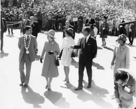
- Photograph of Queen Elizabeth II, acting-mayor Hugh Ladner and his wife (in white), Prince Philip, officials and attendants visiting Burnaby Municipal Hall on May 7, 1971. A large crowd has gathered outside of Burnaby Municipal hall to see the Royal family.
- Repository
- Burnaby Village Museum
- Collection/Fonds
- Donald Copan collection
- Series
- Copan album series
- Description Level
- Item
- Physical Description
- 1 photograph : b&w ; 20.5 x 25.5 cm
- Scope and Content
- Photograph of Queen Elizabeth II, acting-mayor Hugh Ladner and his wife (in white), Prince Philip, officials and attendants visiting Burnaby Municipal Hall on May 7, 1971. A large crowd has gathered outside of Burnaby Municipal hall to see the Royal family.
- Names
- Elizabeth II Queen of Great Britain, 1926-2022
- Ladner, Hugh G.
- Philip, Prince, consort of Elizabeth II, Queen of Great Britain, 1921-2021
- Geographic Access
- Canada Way
- Street Address
- 4949 Canada Way
- Accession Code
- BV005.54.65
- Access Restriction
- No restrictions
- Reproduction Restriction
- May be restricted by third party rights
- Date
- 7 May 1971
- Media Type
- Photograph
- Historic Neighbourhood
- Burnaby Lake (Historic Neighbourhood)
- Planning Study Area
- Douglas-Gilpin Area
- Scan Resolution
- 600
- Scan Date
- 13-Jul-20
- Scale
- 100
- Photographer
- Columbian Photo Limited
- Notes
- Title based on contents of photograph
- Stamp on verso: "Columbian Photo Ltd. 545 Clarkson St., New Westminster, B.C. Phone 521-2622. Local 229."
Images
Royal visit to Burnaby Municipal Hall
https://search.heritageburnaby.ca/link/museumdescription2018
- Repository
- Burnaby Village Museum
- Date
- 7 May 1971
- Collection/Fonds
- Donald Copan collection
- Description Level
- Item
- Physical Description
- 1 photograph : b&w ; 20.5 x 25.5 cm
- Scope and Content
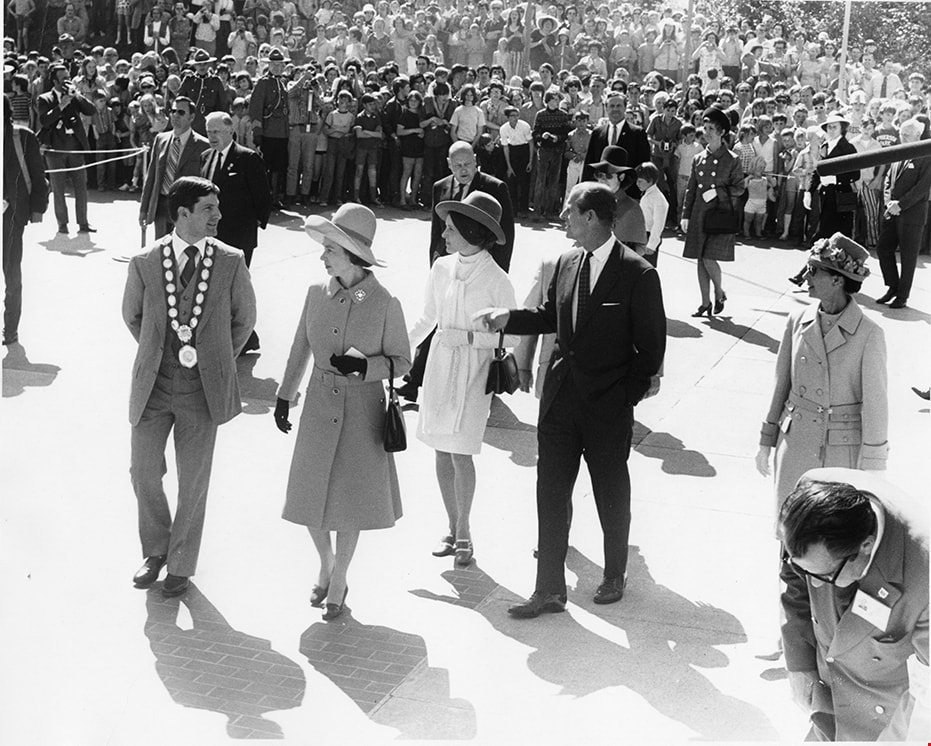
- Photograph of Queen Elizabeth II, acting-mayor Hugh Ladner and his wife (in white), officials and attendants visiting Burnaby Municipal Hall on May 7, 1971.
- Repository
- Burnaby Village Museum
- Collection/Fonds
- Donald Copan collection
- Series
- Copan album series
- Description Level
- Item
- Physical Description
- 1 photograph : b&w ; 20.5 x 25.5 cm
- Scope and Content
- Photograph of Queen Elizabeth II, acting-mayor Hugh Ladner and his wife (in white), officials and attendants visiting Burnaby Municipal Hall on May 7, 1971.
- Geographic Access
- Canada Way
- Street Address
- 4949 Canada Way
- Accession Code
- BV005.54.66
- Access Restriction
- No restrictions
- Reproduction Restriction
- May be restricted by third party rights
- Date
- 7 May 1971
- Media Type
- Photograph
- Historic Neighbourhood
- Burnaby Lake (Historic Neighbourhood)
- Planning Study Area
- Douglas-Gilpin Area
- Scan Resolution
- 600
- Scan Date
- 13-Jul-20
- Scale
- 100
- Photographer
- Columbian Photo Limited
- Notes
- Stamp on verso: "Columbian Photo Ltd. 545 Clarkson St., New Westminster, B.C. Phone 521-2622. Local 229."
- Title based on contents of photograph
Images
