Narrow Results By

Looking southwest from corner of Douglas Road and Dominion Street
https://search.heritageburnaby.ca/link/archivedescription91878
- Repository
- City of Burnaby Archives
- Date
- April 2015
- Collection/Fonds
- Small family fonds
- Description Level
- Item
- Physical Description
- 1 photograph : col. copy print ; 10 cm x 15 cm
- Scope and Content
- Photograph of the houses and trees situated on the southwest corner of Douglas Road and Dominion Street. The large oak, hemlock, and fir were planted as part of the original landscaping of the Roberts' property in the 1920s. The photograph was taken from the Douglas Road and Dominion Street inter…
- Repository
- City of Burnaby Archives
- Date
- April 2015
- Collection/Fonds
- Small family fonds
- Physical Description
- 1 photograph : col. copy print ; 10 cm x 15 cm
- Description Level
- Item
- Record No.
- 620-059
- Access Restriction
- No restrictions
- Reproduction Restriction
- No reproduction permitted
- Accession Number
- 2017-01
- Scope and Content
- Photograph of the houses and trees situated on the southwest corner of Douglas Road and Dominion Street. The large oak, hemlock, and fir were planted as part of the original landscaping of the Roberts' property in the 1920s. The photograph was taken from the Douglas Road and Dominion Street intersection.
- Media Type
- Photograph
- Notes
- Transcribed title
- Title transcribed from donor's notes
- Note in blue ink on verso of photograph reads: "P.21"
- Note in blue ink on verso of photograph reads: "Looking southwest from corner of Douglas Rd. and Dominion St. / Oak Tree Hemlock Tree Fir Tree / planted in late 1920's"
- Note in black ink on verso of photograph reads: "April 2015"
- The oak tree is the same tree as in photographs 620-007, 620-014, 620-015, and 620-016
- Geographic Access
- Dominion Street
- Douglas Road
- Historic Neighbourhood
- Burnaby Lake (Historic Neighbourhood)
- Planning Study Area
- Ardingley-Sprott Area
Images


Looking west along Dominion Street from 5496 Dominion Street
https://search.heritageburnaby.ca/link/archivedescription91873
- Repository
- City of Burnaby Archives
- Date
- July 2016
- Collection/Fonds
- Small family fonds
- Description Level
- Item
- Physical Description
- 1 photograph : col. copy print ; 10 cm x 15 cm
- Scope and Content
- Photograph of the houses along Dominion Street, looking west from 5496 Dominion Street. The two houses in the foreground, 5480 and 5488 Dominion Street, were constructed in 1994 on the lot previously numbered 5486 Dominion Street.
- Repository
- City of Burnaby Archives
- Date
- July 2016
- Collection/Fonds
- Small family fonds
- Physical Description
- 1 photograph : col. copy print ; 10 cm x 15 cm
- Description Level
- Item
- Record No.
- 620-054
- Access Restriction
- No restrictions
- Reproduction Restriction
- No reproduction permitted
- Accession Number
- 2017-01
- Scope and Content
- Photograph of the houses along Dominion Street, looking west from 5496 Dominion Street. The two houses in the foreground, 5480 and 5488 Dominion Street, were constructed in 1994 on the lot previously numbered 5486 Dominion Street.
- Subjects
- Buildings - Residential - Houses
- Media Type
- Photograph
- Notes
- Transcribed title
- Title transcribed from donor's notes
- Note in blue ink on verso of photograph reads: "P.16"
- Note in blue ink on verso of photograph reads: "Houses at 5480 and 5488 Dominion St. / built in 1994"
- Photo production stamp on verso of photograph reads: "07/03/2016"
- Street Address
- 5488 Dominion Street
- 5480 Dominion Street
- Historic Neighbourhood
- Burnaby Lake (Historic Neighbourhood)
- Planning Study Area
- Ardingley-Sprott Area
Images


Looking west along Dominion Street from across the street from 5496 Dominion Street
https://search.heritageburnaby.ca/link/archivedescription91874
- Repository
- City of Burnaby Archives
- Date
- July 2016
- Collection/Fonds
- Small family fonds
- Description Level
- Item
- Physical Description
- 1 photograph : col. copy print ; 10 cm x 15 cm
- Scope and Content
- Photograph of the houses along the south side of Dominion Street with cars parked along the curb. In 2009 sidewalks were installed and the street was repaved under a neighbourhood local improvement request to the City. The photograph was taken from the north side of the street, opposite 5496 Dom…
- Repository
- City of Burnaby Archives
- Date
- July 2016
- Collection/Fonds
- Small family fonds
- Physical Description
- 1 photograph : col. copy print ; 10 cm x 15 cm
- Description Level
- Item
- Record No.
- 620-055
- Access Restriction
- No restrictions
- Reproduction Restriction
- No reproduction permitted
- Accession Number
- 2017-01
- Scope and Content
- Photograph of the houses along the south side of Dominion Street with cars parked along the curb. In 2009 sidewalks were installed and the street was repaved under a neighbourhood local improvement request to the City. The photograph was taken from the north side of the street, opposite 5496 Dominion Street, looking west.
- Media Type
- Photograph
- Notes
- Transcribed title
- Title transcribed from donor's notes
- Note in blue ink on verso of photograph reads: "P.17"
- Note in blue ink on verso of photograph reads: "Dominion St. infilled with houses on 33' lots / Photo July 2016"
- Geographic Access
- Dominion Street
- Historic Neighbourhood
- Burnaby Lake (Historic Neighbourhood)
- Planning Study Area
- Ardingley-Sprott Area
Images


Looking west along the back lane
https://search.heritageburnaby.ca/link/archivedescription91861
- Repository
- City of Burnaby Archives
- Date
- April 2015
- Collection/Fonds
- Small family fonds
- Description Level
- Item
- Physical Description
- 1 photograph : col. ; 10 cm x 15 cm
- Scope and Content
- Photograph of the back lane between Dominion Street and Norfolk Street, looking west. Visible along the Norfolk Street side of the lane are houses with garages and longer driveways. Along the Dominion Street side the lane is abutted by trees and open carports. The houses along Norfolk Street wer…
- Repository
- City of Burnaby Archives
- Date
- April 2015
- Collection/Fonds
- Small family fonds
- Physical Description
- 1 photograph : col. ; 10 cm x 15 cm
- Description Level
- Item
- Record No.
- 620-042
- Access Restriction
- No restrictions
- Reproduction Restriction
- No reproduction permitted
- Accession Number
- 2017-01
- Scope and Content
- Photograph of the back lane between Dominion Street and Norfolk Street, looking west. Visible along the Norfolk Street side of the lane are houses with garages and longer driveways. Along the Dominion Street side the lane is abutted by trees and open carports. The houses along Norfolk Street were constructed in the 1980s and 1990s following the rezoning of the properties.
- Media Type
- Photograph
- Notes
- Transcribed title
- Title transcribed from donor's notes
- Note in blue ink on verso of photograph reads: "P.5"
- Note in blue ink on verso of photograph reads: "April 1, 2015"
- Historic Neighbourhood
- Burnaby Lake (Historic Neighbourhood)
- Planning Study Area
- Ardingley-Sprott Area
Images

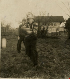
Looking west from back yard of 5486 Dominion Street
https://search.heritageburnaby.ca/link/archivedescription91869
- Repository
- City of Burnaby Archives
- Date
- 1961
- Collection/Fonds
- Small family fonds
- Description Level
- Item
- Physical Description
- 1 photograph : sepia ; 8 cm x 6.5 cm
- Scope and Content
- Photograph of Martin and Charles Shaw playing the backyard at 5486 Dominion Street. The house at 5466 Dominion Street, which likely predates the Roberts' house, is visible in the background. The photograph was taken from the backyard of 5486 Dominion Street, looking west.
- Repository
- City of Burnaby Archives
- Date
- 1961
- Collection/Fonds
- Small family fonds
- Physical Description
- 1 photograph : sepia ; 8 cm x 6.5 cm
- Description Level
- Item
- Record No.
- 620-050
- Access Restriction
- No restrictions
- Reproduction Restriction
- No reproduction permitted
- Accession Number
- 2017-01
- Scope and Content
- Photograph of Martin and Charles Shaw playing the backyard at 5486 Dominion Street. The house at 5466 Dominion Street, which likely predates the Roberts' house, is visible in the background. The photograph was taken from the backyard of 5486 Dominion Street, looking west.
- Media Type
- Photograph
- Notes
- Transcribed title
- Title transcribed from donor's notes
- Note in blue ink on verso of photograph reads: "P12"
- Note in blue ink on verso of photograph reads: "Charles 7 / Martin 5"
- Note in blue ink on verso of photograph reads: "Between March and Jun 1961"
- 5486 Dominion Street later subdivided into two lots: 5480 and 5488 Dominion Street
- 5466 Dominion Street later subdivided into two lots: 5462 and 5468 Dominion Street
- Street Address
- 5466 Dominion Street
- 5486 Dominion Street
- Historic Neighbourhood
- Burnaby Lake (Historic Neighbourhood)
- Planning Study Area
- Ardingley-Sprott Area
Images


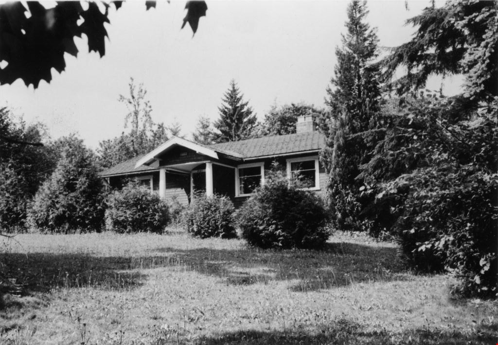
Looking west from back yard of 5496 Dominion Street
https://search.heritageburnaby.ca/link/archivedescription91866
- Repository
- City of Burnaby Archives
- Date
- April 1, 2015
- Collection/Fonds
- Small family fonds
- Description Level
- Item
- Physical Description
- 1 photograph : col. copy print ; 10 cm x 15 cm
- Scope and Content
- Photograph of the backyard at 5496 Dominion Street, looking west, with the houses on Norfolk Street (left) and Dominion Street (right) visible in the background.
- Repository
- City of Burnaby Archives
- Date
- April 1, 2015
- Collection/Fonds
- Small family fonds
- Physical Description
- 1 photograph : col. copy print ; 10 cm x 15 cm
- Description Level
- Item
- Record No.
- 620-047
- Access Restriction
- No restrictions
- Reproduction Restriction
- No reproduction permitted
- Accession Number
- 2017-01
- Scope and Content
- Photograph of the backyard at 5496 Dominion Street, looking west, with the houses on Norfolk Street (left) and Dominion Street (right) visible in the background.
- Media Type
- Photograph
- Notes
- Transcribed title
- Title transcribed from donor's notes
- Note in blue ink on verso of photograph reads: "P.10"
- Note in black ink on verso of photograph reads: "April 1, 2015"
- Geographic Access
- Dominion Street
- Norfolk Street
- Street Address
- 5496 Dominion Street
- Historic Neighbourhood
- Burnaby Lake (Historic Neighbourhood)
- Planning Study Area
- Ardingley-Sprott Area
Images


Looking west from Douglas Road
https://search.heritageburnaby.ca/link/archivedescription91832
- Repository
- City of Burnaby Archives
- Date
- 1969
- Collection/Fonds
- Small family fonds
- Description Level
- Item
- Physical Description
- 1 photograph : b&w ; 9 cm x 12.5 cm
- Scope and Content
- Photograph of Roberts' house and front lawn at 3131 Douglas Road (previously 5118 Douglas Road). The photograph was taken from Douglas Road, looking west.
- Repository
- City of Burnaby Archives
- Date
- 1969
- Collection/Fonds
- Small family fonds
- Physical Description
- 1 photograph : b&w ; 9 cm x 12.5 cm
- Description Level
- Item
- Record No.
- 620-013
- Access Restriction
- No restrictions
- Reproduction Restriction
- No reproduction permitted
- Accession Number
- 2017-01
- Scope and Content
- Photograph of Roberts' house and front lawn at 3131 Douglas Road (previously 5118 Douglas Road). The photograph was taken from Douglas Road, looking west.
- Subjects
- Buildings - Residential - Houses
- Media Type
- Photograph
- Notes
- Transcribed title
- Title transcribed from donor's notes
- Note in black ink on verso of photograph reads: "1969 / Roberts' house and front lawn"
- Note in blue ink on verso of photograph reads: "P.13"
- Stamp in black ink on verso of photograph reads: "11.8.69"
- 5118 Douglas Road renumbered to 3131 Douglas Road in 1958 and to 5538 Dominion Street in 1970 or 1971
- Street Address
- 3131 Douglas Road
- 5118 Douglas Road
- 5538 Dominion Street
- Historic Neighbourhood
- Burnaby Lake (Historic Neighbourhood)
- Planning Study Area
- Ardingley-Sprott Area
Images

Looking west from Douglas Road
https://search.heritageburnaby.ca/link/archivedescription91834
- Repository
- City of Burnaby Archives
- Date
- April 2015
- Collection/Fonds
- Small family fonds
- Description Level
- Item
- Physical Description
- 1 photograph : col. copy print ; 10 cm x 15 cm
- Scope and Content
- Photograph of the houses located on the corner of Douglas Road and Dominion Street, with a large oak tree in the front of the yard. The house on the left is 3131 Douglas Road; the house behind is 5536 Dominion Street. The photograph was taken from Douglas Road, looking west.
- Repository
- City of Burnaby Archives
- Date
- April 2015
- Collection/Fonds
- Small family fonds
- Physical Description
- 1 photograph : col. copy print ; 10 cm x 15 cm
- Description Level
- Item
- Record No.
- 620-015
- Access Restriction
- No restrictions
- Reproduction Restriction
- No reproduction permitted
- Accession Number
- 2017-01
- Scope and Content
- Photograph of the houses located on the corner of Douglas Road and Dominion Street, with a large oak tree in the front of the yard. The house on the left is 3131 Douglas Road; the house behind is 5536 Dominion Street. The photograph was taken from Douglas Road, looking west.
- Media Type
- Photograph
- Notes
- Transcribed title
- Title transcribed from donor's notes
- Note in blue ink on verso of photograph reads: "April 2015 / 3131 Douglas Rd. / with Oak Tree"
- Note in blue ink on verso of photograph reads: "P.15"
- 5118 Douglas Road renumbered to 3131 Douglas Road in 1958 and to 5538 Dominion Street in 1970 or 1971
- The oak tree (centre) is the same tree as in photographs 620-007 and 620-014
- Street Address
- 3131 Douglas Road
- 5118 Douglas Road
- 5538 Dominion Street
- Historic Neighbourhood
- Burnaby Lake (Historic Neighbourhood)
- Planning Study Area
- Ardingley-Sprott Area
Images

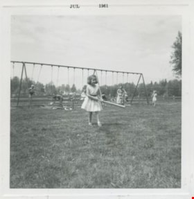
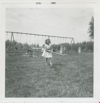
Louise Emmonds at Deer lake
https://search.heritageburnaby.ca/link/archivedescription52979
- Repository
- City of Burnaby Archives
- Date
- July 1961
- Collection/Fonds
- Burnaby Historical Society fonds
- Description Level
- Item
- Physical Description
- 1 photograph : b&w ; 7.5 x 7.5 cm, mounted on heavy-weight paper 17.5 x 27.5 cm
- Scope and Content
- Photograph of Louise Emmonds swinging a bat at Dear lake. She is wearing a white dress with a black belt. Children can be seen swinging on a large swing set (with the help of adults) in the background.
- Repository
- City of Burnaby Archives
- Date
- July 1961
- Collection/Fonds
- Burnaby Historical Society fonds
- Subseries
- Tinkerbell Kindergarten subseries
- Physical Description
- 1 photograph : b&w ; 7.5 x 7.5 cm, mounted on heavy-weight paper 17.5 x 27.5 cm
- Description Level
- Item
- Record No.
- 246-019
- Access Restriction
- No restrictions
- Reproduction Restriction
- Reproduce for fair dealing purposes only
- Accession Number
- BHS1990-12
- Scope and Content
- Photograph of Louise Emmonds swinging a bat at Dear lake. She is wearing a white dress with a black belt. Children can be seen swinging on a large swing set (with the help of adults) in the background.
- Media Type
- Photograph
- Notes
- Title based on contents of photograph
- Handwritten note on paper mount reads: "Deer Lake / 1960 - 1961 / mis [sic] Louise Emmonds"
- Geographic Access
- Deer Lake
- Deer Lake Park
- Deer Lake Avenue
- Historic Neighbourhood
- Burnaby Lake (Historic Neighbourhood)
- Planning Study Area
- Douglas-Gilpin Area
Images
Lubbock photographs from album
https://search.heritageburnaby.ca/link/archivedescription64493
- Repository
- City of Burnaby Archives
- Date
- 1945-1988
- Collection/Fonds
- Burnaby Historical Society fonds
- Description Level
- File
- Physical Description
- 130 photographs : b&w and col. ; 20.5 x 25.5 cm or smaller
- Scope and Content
- Photographs of the Lubbock family, including their riding stables and horses, family events, their pets, and landscape and travel photographs. These photographs were originally housed in a photographic album.
- Repository
- City of Burnaby Archives
- Date
- 1945-1988
- Collection/Fonds
- Burnaby Historical Society fonds
- Subseries
- Lubbock family subseries
- Physical Description
- 130 photographs : b&w and col. ; 20.5 x 25.5 cm or smaller
- Description Level
- File
- Record No.
- 342-046
- Access Restriction
- In Archives only
- Reproduction Restriction
- May be restricted by third party rights
- Accession Number
- BHS1994-02
- Scope and Content
- Photographs of the Lubbock family, including their riding stables and horses, family events, their pets, and landscape and travel photographs. These photographs were originally housed in a photographic album.
- Names
- Lubbock, Ainsly
- Lubbock, Beatrice "Bea"
- Lubbock, Elizabeth
- Lubbock, Gordon
- Lubbock, John
- Lubbock, John Barker
- Lubbock, Mina
- Media Type
- Photograph
- Notes
- Title based on contents of photograph
- Geographic Access
- Grandview Highway
- Canada Way
- Burris Street
- Street Address
- 7803 Burris Street
- Historic Neighbourhood
- Burnaby Lake (Historic Neighbourhood)
- Planning Study Area
- Morley-Buckingham Area

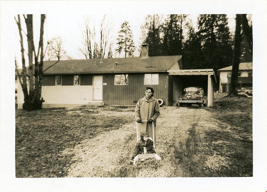
Lucy and Sjouke Hiemstra in front of house
https://search.heritageburnaby.ca/link/museumdescription19127
- Repository
- Burnaby Village Museum
- Date
- Feb. 1960
- Collection/Fonds
- Cornelius and Lucy Hiemstra family fonds
- Description Level
- Item
- Physical Description
- 1 photograph : b&w ; 8.5 x 11.5 cm
- Scope and Content
- Photograph of Lucy Hiemstra pushing her eldest child Sjouke Hiemstra in a stroller on the grass in front of their house located at 5636 Canada Way.
- Repository
- Burnaby Village Museum
- Collection/Fonds
- Cornelius and Lucy Hiemstra family fonds
- Description Level
- Item
- Physical Description
- 1 photograph : b&w ; 8.5 x 11.5 cm
- Scope and Content
- Photograph of Lucy Hiemstra pushing her eldest child Sjouke Hiemstra in a stroller on the grass in front of their house located at 5636 Canada Way.
- Geographic Access
- Canada Way
- Accession Code
- BV022.15.7
- Access Restriction
- No restrictions
- Reproduction Restriction
- May be restricted by third party rights
- Date
- Feb. 1960
- Media Type
- Photograph
- Historic Neighbourhood
- Burnaby Lake (Historic Neighbourhood)
- Planning Study Area
- Burnaby Lake Area
- Notes
- Title based on contents of photograph
- note in blue ink on verso of photograph reads: "Feb. 1960 / Sg. C. Hiemstra Jr."
- Stamp on verso of photograph reads: "919A"
Images

Madelaine Anderson
https://search.heritageburnaby.ca/link/archivedescription37452
- Repository
- City of Burnaby Archives
- Date
- 1963 (date of original), copied 1991
- Collection/Fonds
- Burnaby Historical Society fonds
- Description Level
- Item
- Physical Description
- 1 photograph : b&w ; 3.2 x 3.2 cm print on contact sheet 20.2 x 25.4 cm
- Scope and Content
- Photograph of Madelaine Anderson at the back of her home at 3908 Norland Avenue (previously numbered 4437 Norland Avenue), facing northwest. The Sprott overpass over the Trans Canada Highway can be seen under construction in the background.
- Repository
- City of Burnaby Archives
- Date
- 1963 (date of original), copied 1991
- Collection/Fonds
- Burnaby Historical Society fonds
- Subseries
- Burnaby Image Bank subseries
- Physical Description
- 1 photograph : b&w ; 3.2 x 3.2 cm print on contact sheet 20.2 x 25.4 cm
- Description Level
- Item
- Record No.
- 370-040
- Access Restriction
- No restrictions
- Reproduction Restriction
- No restrictions
- Accession Number
- BHS1999-03
- Scope and Content
- Photograph of Madelaine Anderson at the back of her home at 3908 Norland Avenue (previously numbered 4437 Norland Avenue), facing northwest. The Sprott overpass over the Trans Canada Highway can be seen under construction in the background.
- Media Type
- Photograph
- Notes
- Title based on contents of photograph
- 1 b&w copy negative accompanying
- Photo is missing pieces at centre and bottom left
- Geographic Access
- Norland Avenue
- Street Address
- 3908 Norland Avenue
- Historic Neighbourhood
- Burnaby Lake (Historic Neighbourhood)
- Planning Study Area
- Douglas-Gilpin Area
Images


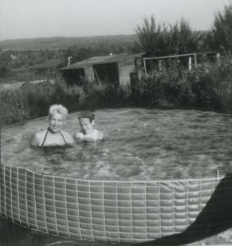
Madelaine and Janet Anderson in their pool
https://search.heritageburnaby.ca/link/archivedescription37445
- Repository
- City of Burnaby Archives
- Date
- 1961 (date of original), copied 1991
- Collection/Fonds
- Burnaby Historical Society fonds
- Description Level
- Item
- Physical Description
- 1 photograph : b&w ; 4.0 x 3.7 cm print on contact sheet 20.2 x 25.4 cm
- Scope and Content
- Photograph of mother and daughter Madelaine and Janet Anderson in the swimming pool behind their home at 3908 Norland Avenue (previously numbered 4437 Norland Avenue).
- Repository
- City of Burnaby Archives
- Date
- 1961 (date of original), copied 1991
- Collection/Fonds
- Burnaby Historical Society fonds
- Subseries
- Burnaby Image Bank subseries
- Physical Description
- 1 photograph : b&w ; 4.0 x 3.7 cm print on contact sheet 20.2 x 25.4 cm
- Description Level
- Item
- Record No.
- 370-033
- Access Restriction
- No restrictions
- Reproduction Restriction
- No restrictions
- Accession Number
- BHS1999-03
- Scope and Content
- Photograph of mother and daughter Madelaine and Janet Anderson in the swimming pool behind their home at 3908 Norland Avenue (previously numbered 4437 Norland Avenue).
- Media Type
- Photograph
- Notes
- Title based on contents of photograph
- 1 b&w copy negative accompanying
- Geographic Access
- Norland Avenue
- Street Address
- 3908 Norland Avenue
- Historic Neighbourhood
- Burnaby Lake (Historic Neighbourhood)
- Planning Study Area
- Douglas-Gilpin Area
Images
![North side of Burnaby Lake, January 1962 (date of original), copied [1985] thumbnail](/media/hpo/_Data/_BVM_Images/1985/1985_0457_0001_001.jpg?width=280)
North side of Burnaby Lake
https://search.heritageburnaby.ca/link/museumdescription10582
- Repository
- Burnaby Village Museum
- Date
- January 1962 (date of original), copied [1985]
- Collection/Fonds
- Burnaby Village Museum Photograph Collection
- Description Level
- Item
- Physical Description
- 1 photograph : b&w copy negative ; 10 x 12.5 cm
- Scope and Content
- Photograph of the north side of Burnaby Lake January 1962. Preparation for 36 water main crossing at Piper Avenue. The lake and ground are covered with snow.
- Repository
- Burnaby Village Museum
- Collection/Fonds
- Burnaby Village Museum Photograph Collection
- Description Level
- Item
- Physical Description
- 1 photograph : b&w copy negative ; 10 x 12.5 cm
- Scope and Content
- Photograph of the north side of Burnaby Lake January 1962. Preparation for 36 water main crossing at Piper Avenue. The lake and ground are covered with snow.
- Accession Code
- BV985.457.1
- Access Restriction
- No restrictions
- Reproduction Restriction
- May be restricted by third party rights
- Date
- January 1962 (date of original), copied [1985]
- Media Type
- Photograph
- Historic Neighbourhood
- Burnaby Lake (Historic Neighbourhood)
- Planning Study Area
- Burnaby Lake Area
- Scan Resolution
- 1200
- Scan Date
- 2022-06-07
- Photographer
- Lindsay, Jack
- Notes
- Title based on contents of photograph
- Photo by Jack Lindsay Ltd. Photographers, Vancouver. #D28833
Images
![North side of Burnaby Lake, January 1962 (date of original), copied [1985] thumbnail](/media/hpo/_Data/_BVM_Images/1985/1985_0457_0001_001.jpg)
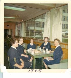
Nurses on coffee break
https://search.heritageburnaby.ca/link/archivedescription65514
- Repository
- City of Burnaby Archives
- Date
- 1965
- Collection/Fonds
- Victorian Order of Nurses fonds
- Description Level
- Item
- Physical Description
- 1 photograph : col. ; 8 x 8 cm
- Scope and Content
- Photograph of five Victorian Order of Nurses (VON) nurses having coffee break together at the Municipal Hall in Burnaby. The nurses are; (from left) Sue Cornelisse, Margaret Standerwick, Nettie Klokeid, Betty-Lou Sundquist and Marguerite Dobson.
- Repository
- City of Burnaby Archives
- Date
- 1965
- Collection/Fonds
- Victorian Order of Nurses fonds
- Physical Description
- 1 photograph : col. ; 8 x 8 cm
- Description Level
- Item
- Record No.
- 153-052
- Access Restriction
- No restrictions
- Reproduction Restriction
- Reproduce for fair dealing purposes only
- Accession Number
- 2010-09
- Scope and Content
- Photograph of five Victorian Order of Nurses (VON) nurses having coffee break together at the Municipal Hall in Burnaby. The nurses are; (from left) Sue Cornelisse, Margaret Standerwick, Nettie Klokeid, Betty-Lou Sundquist and Marguerite Dobson.
- Subjects
- Occupations - Nurses
- Names
- Victorian Order of Nurses
- Cornelisse, Sue
- Standerwick, Margaret
- Klokeid, Nettie
- Sundquist, Betty-Lou
- Dobson, Marguerite
- Media Type
- Photograph
- Notes
- Title based on contents of photograph
- Note on verso of photograph reads: “Coffee break in Municipal Hall / Cafeteria / L. to Right / Sue Cornelisse / Margaret Standerwick / Nettie Klokied [sic] / Betty-Lou Sundquist / Marguerite Dobson"
- Note on recto of photograph reads: “1965”
- Geographic Access
- Canada Way
- Street Address
- 4949 Canada Way
- Historic Neighbourhood
- Burnaby Lake (Historic Neighbourhood)
- Planning Study Area
- Douglas-Gilpin Area
Images

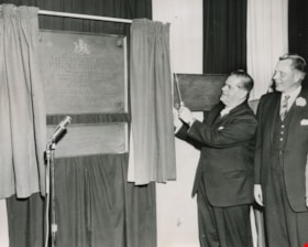
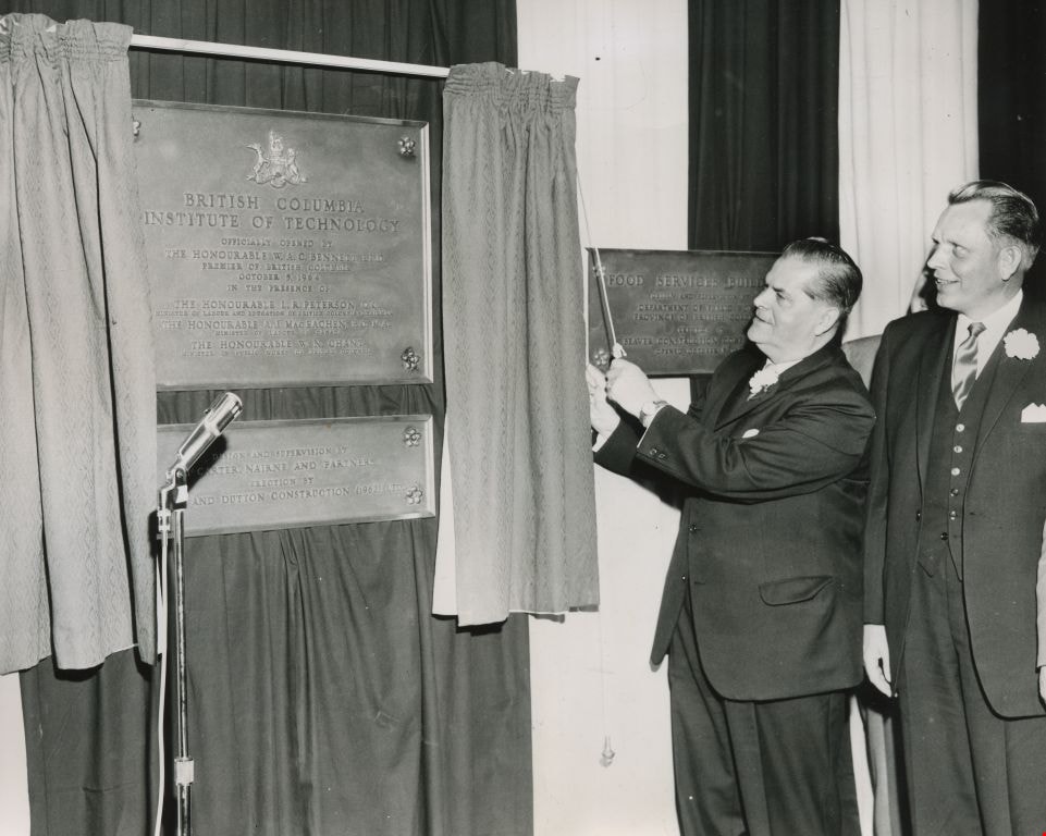
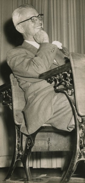
Official opening by Premier W. A. C. Bennett
https://search.heritageburnaby.ca/link/archivedescription45453
- Repository
- City of Burnaby Archives
- Date
- October 5, 1964
- Collection/Fonds
- Columbian Newspaper collection
- Description Level
- Item
- Physical Description
- 1 photograph : b&w ; 15 x 18.5 cm
- Scope and Content
- Photograph of W.A.C. Bennett pulling back the curtain to unveil the plaque at the official opening of the British Columbia Institute of Technology.
- Repository
- City of Burnaby Archives
- Date
- October 5, 1964
- Collection/Fonds
- Columbian Newspaper collection
- Physical Description
- 1 photograph : b&w ; 15 x 18.5 cm
- Description Level
- Item
- Record No.
- 480-348
- Access Restriction
- No restrictions
- Reproduction Restriction
- Reproduce for fair dealing purposes only
- Accession Number
- 2003-02
- Scope and Content
- Photograph of W.A.C. Bennett pulling back the curtain to unveil the plaque at the official opening of the British Columbia Institute of Technology.
- Subjects
- Events - Openings
- Officials - Premiers
- Media Type
- Photograph
- Notes
- Title based on contents of photograph
- Geographic Access
- Willingdon Avenue
- Street Address
- 3700 Willingdon Avenue
- Historic Neighbourhood
- Burnaby Lake (Historic Neighbourhood)
- Planning Study Area
- Douglas-Gilpin Area
Images
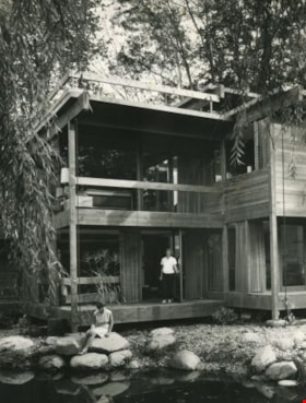
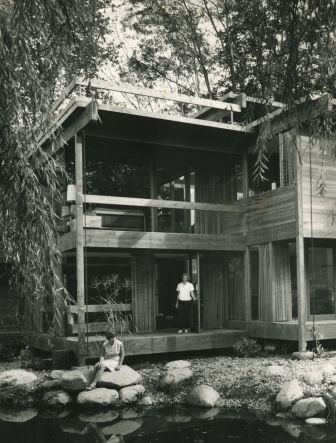
Pond in front of the Baldwin house
https://search.heritageburnaby.ca/link/archivedescription37349
- Repository
- City of Burnaby Archives
- Date
- 1966
- Collection/Fonds
- Burnaby Historical Society fonds
- Description Level
- Item
- Physical Description
- 1 photograph : b&w ; 19 x 25.5 cm
- Scope and Content
- Photograph of two women, one standing in the doorway and another seated on a rock at the edge of the water, outside the Dr. William and Ruth Baldwin House at Deer Lake. A note on the back of the photograph indicates that one of the women may be Susan Baldwin.
- Repository
- City of Burnaby Archives
- Date
- 1966
- Collection/Fonds
- Burnaby Historical Society fonds
- Subseries
- Baldwin family subseries
- Physical Description
- 1 photograph : b&w ; 19 x 25.5 cm
- Description Level
- Item
- Record No.
- 357-004
- Access Restriction
- No restrictions
- Reproduction Restriction
- Reproduce for fair dealing purposes only
- Accession Number
- BHS1998-03
- Scope and Content
- Photograph of two women, one standing in the doorway and another seated on a rock at the edge of the water, outside the Dr. William and Ruth Baldwin House at Deer Lake. A note on the back of the photograph indicates that one of the women may be Susan Baldwin.
- Names
- Baldwin, Susan
- Media Type
- Photograph
- Photographer
- King, Basil
- Notes
- Title based on contents of photograph.
- This photograph is the same as item no. 357-006
- Geographic Access
- Deer Lake Drive
- Street Address
- 6543 Deer Lake Drive
- Historic Neighbourhood
- Burnaby Lake (Historic Neighbourhood)
- Planning Study Area
- Morley-Buckingham Area
Images
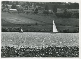
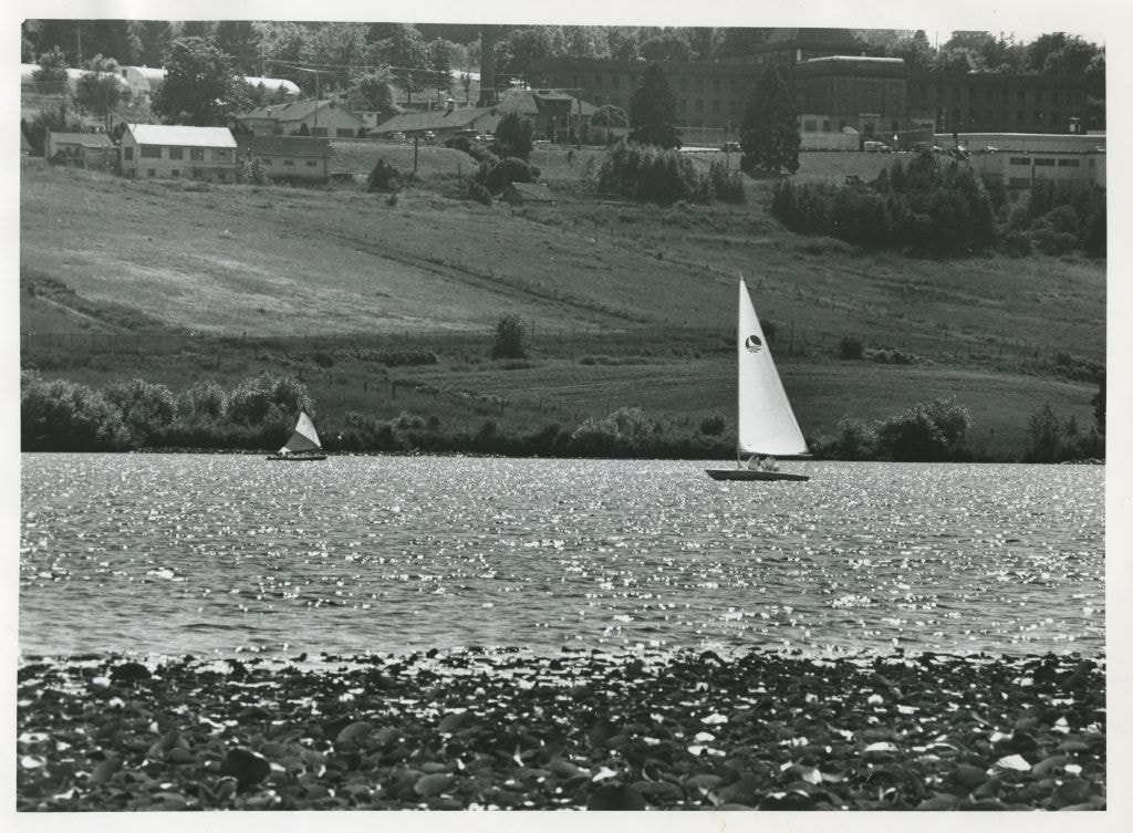
Sailboats on Deer Lake
https://search.heritageburnaby.ca/link/archivedescription58902
- Repository
- City of Burnaby Archives
- Date
- ca.1965
- Collection/Fonds
- Columbian Newspaper collection
- Description Level
- Item
- Physical Description
- 1 photograph : b&w ; 19.5 x 20.5 cm
- Scope and Content
- Photograph of sailboats on Deer Lake. Oakalla Prison Farm is visible on the hill in the background.
- Repository
- City of Burnaby Archives
- Date
- ca.1965
- Collection/Fonds
- Columbian Newspaper collection
- Physical Description
- 1 photograph : b&w ; 19.5 x 20.5 cm
- Description Level
- Item
- Record No.
- 480-1359
- Access Restriction
- No restrictions
- Reproduction Restriction
- Reproduce for fair dealing purposes only
- Accession Number
- 2009-01
- Scope and Content
- Photograph of sailboats on Deer Lake. Oakalla Prison Farm is visible on the hill in the background.
- Subjects
- Recreational Activities - Boating
- Names
- Oakalla Prison Farm
- Media Type
- Photograph
- Photographer
- Battistoni, Peter
- Notes
- Title based on contents of photograph
- Photographer's stamp on verso
- Note on verso reads: "PMT 100% / page 12 / Burnaby Today"
- Geographic Access
- Deer Lake
- Historic Neighbourhood
- Burnaby Lake (Historic Neighbourhood)
- Planning Study Area
- Oakalla Area
Images
School Principal Burwell Brown
https://search.heritageburnaby.ca/link/archivedescription45177
- Repository
- City of Burnaby Archives
- Date
- 1960, published June 4, 1960
- Collection/Fonds
- Columbian Newspaper collection
- Description Level
- Item
- Physical Description
- 1 photograph : b&w ; 20 x 9.5 cm
- Scope and Content
- Photograph of Burwell Brown, Cascade Heights Elementary School Principal, taken the night of his retirement party at Burnaby Central High School. He is sitting in the "prisoner's box" at a mock trial that found him guilty of being an outstanding principal and teacher in Burnaby. He was the principa…
- Repository
- City of Burnaby Archives
- Date
- 1960, published June 4, 1960
- Collection/Fonds
- Columbian Newspaper collection
- Physical Description
- 1 photograph : b&w ; 20 x 9.5 cm
- Description Level
- Item
- Record No.
- 480-073
- Access Restriction
- No restrictions
- Reproduction Restriction
- Reproduce for fair dealing purposes only
- Accession Number
- 2003-02
- Scope and Content
- Photograph of Burwell Brown, Cascade Heights Elementary School Principal, taken the night of his retirement party at Burnaby Central High School. He is sitting in the "prisoner's box" at a mock trial that found him guilty of being an outstanding principal and teacher in Burnaby. He was the principal of Schou Street School from 1927 to 1953, before taking the same position at Cascade Heights Elementary School.
- Names
- Brown, Burwell
- Burnaby Central Secondary School
- Schou Street School
- Cascade Heights Elementary School
- Media Type
- Photograph
- Notes
- Title based on contents of photograph
- Geographic Access
- Canada Way
- Street Address
- 4939 Canada Way
- Historic Neighbourhood
- Burnaby Lake (Historic Neighbourhood)
- Planning Study Area
- Douglas-Gilpin Area
Images

![Tea at the Kincaid house, [196-] (date of original), copied 1995 thumbnail](/media/Hpo/_Data/_Archives_Images/_Unrestricted/316/324-002.jpg?width=280)
Tea at the Kincaid house
https://search.heritageburnaby.ca/link/archivedescription37125
- Repository
- City of Burnaby Archives
- Date
- [196-] (date of original), copied 1995
- Collection/Fonds
- Burnaby Historical Society fonds
- Description Level
- Item
- Physical Description
- 1 photograph : b&w ; 8.5 x 12.5 cm print
- Scope and Content
- Photograph of three people sitting outside on lawn chairs having tea together at the Kincaid house on Glencarin Drive. There is a dog and a tricycle on the lawn.
- Repository
- City of Burnaby Archives
- Date
- [196-] (date of original), copied 1995
- Collection/Fonds
- Burnaby Historical Society fonds
- Subseries
- Photographs subseries
- Physical Description
- 1 photograph : b&w ; 8.5 x 12.5 cm print
- Description Level
- Item
- Record No.
- 324-002
- Access Restriction
- No restrictions
- Reproduction Restriction
- Reproduce for fair dealing purposes only
- Accession Number
- BHS1995-18
- Scope and Content
- Photograph of three people sitting outside on lawn chairs having tea together at the Kincaid house on Glencarin Drive. There is a dog and a tricycle on the lawn.
- Media Type
- Photograph
- Notes
- Title based on contents of photograph
- Geographic Access
- Glencarin Drive
- Historic Neighbourhood
- Burnaby Lake (Historic Neighbourhood)
- Planning Study Area
- Burnaby Lake Area
Images
![Tea at the Kincaid house, [196-] (date of original), copied 1995 thumbnail](/media/Hpo/_Data/_Archives_Images/_Unrestricted/316/324-002.jpg)