Narrow Results By
Person / Organization
- Ah Sam 1
- Allen, James Charles 1
- Avendaño, Adrian 1
- Bingham, Alfred "Alf" 3
- Bird, Elizabeth "Bess" Cross Hart 2
- Bond, Evelyn 1
- Bradbury, Dr. Bettina 3
- British Columbia Electric Railway 2
- British Columbia Electric Railway Company 1
- British Columbia Hydro and Power Authority 1
- Brown, Alex 1
- Brown, Percy Boyer 1
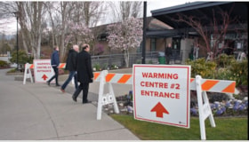
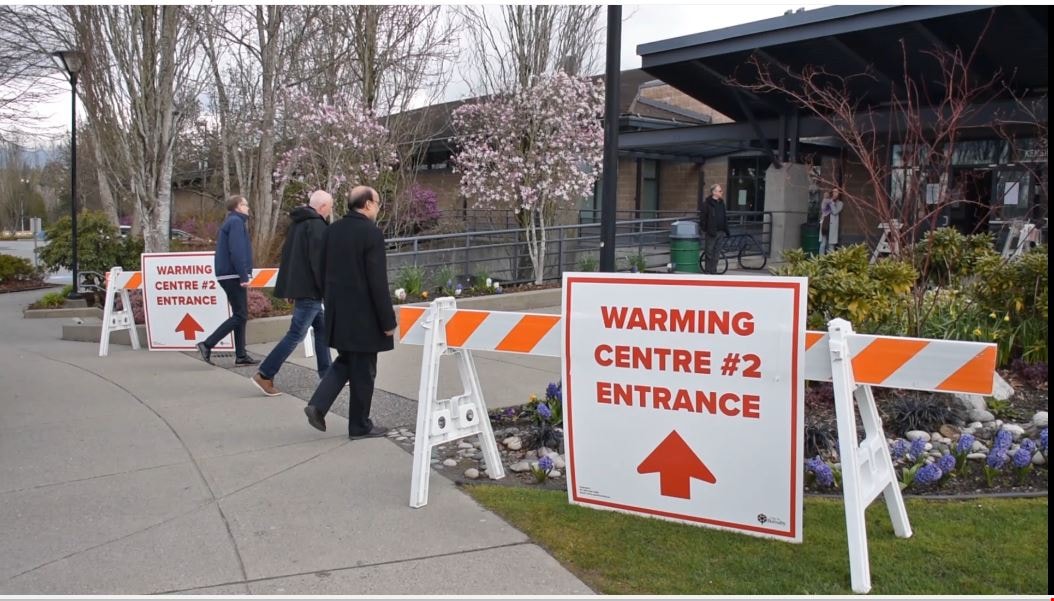
COVID-19 warming centre #2
https://search.heritageburnaby.ca/link/museumdescription15384
- Repository
- Burnaby Village Museum
- Date
- 2 Apr 2020
- Collection/Fonds
- Burnaby Village Museum COVID-19 collection
- Description Level
- Item
- Physical Description
- 1 video recording (mp4) (55 min.) : digital, 24 fps, col., sd., stereo
- Scope and Content
- City of Burnaby informational film regarding the launch of a new warming centre for the community. Burnaby Mayor Mike Hurley explains how the city has consolidated two of it's smaller warming centres (Kensington and Swanguard) and opened a new larger one inside the Burnaby Lake Arena. The mayor exp…
- Repository
- Burnaby Village Museum
- Collection/Fonds
- Burnaby Village Museum COVID-19 collection
- Description Level
- Item
- Physical Description
- 1 video recording (mp4) (55 min.) : digital, 24 fps, col., sd., stereo
- Scope and Content
- City of Burnaby informational film regarding the launch of a new warming centre for the community. Burnaby Mayor Mike Hurley explains how the city has consolidated two of it's smaller warming centres (Kensington and Swanguard) and opened a new larger one inside the Burnaby Lake Arena. The mayor explains the set up and precautions that have been taken to prevent the spread of COVID-19.
- History
- Video taken by the City of Burnaby Marketing Department in 2020. The original intent of the clip was to produce communications about the pandemic and changes throughout the City that residents needed to be aware of.
- Creator
- City of Burnaby
- Subjects
- Buildings - Recreational - Sports
- Officials - Mayors and Reeves
- Emergency Measures
- Public Services - Municipal Services
- Pandemics - COVID-19
- Names
- Hurley, Mike
- City of Burnaby
- Geographic Access
- Kensington Avenue
- Street Address
- 3676 Kensington Avenue
- Accession Code
- BV021.2.1
- Access Restriction
- No restrictions
- Reproduction Restriction
- May be restricted by third party rights
- Date
- 2 Apr 2020
- Media Type
- Moving Images
- Historic Neighbourhood
- Burnaby Lake (Historic Neighbourhood)
- Planning Study Area
- Ardingley-Sprott Area
- Notes
- Title based on contents of film
Images
Video
COVID-19 warming centre #2, 2 Apr 2020
COVID-19 warming centre #2, 2 Apr 2020
https://search.heritageburnaby.ca/media/hpo/_Data/_BVM_Moving_Images/2021_0002_0001_001.mp4
Deer Lake
https://search.heritageburnaby.ca/link/archivedescription34551
- Repository
- City of Burnaby Archives
- Date
- 1914
- Collection/Fonds
- Burnaby Historical Society fonds
- Description Level
- Item
- Physical Description
- 1 photograph : sepia ; 16.1 x 21.3 cm mounted on 25.1 x 30.1 cm cardboard
- Scope and Content
- Photograph of Deer Lake. An earlier catalogue record from 1988 notes that the view is of the north shore of Deer Lake, looking northeast. Also noted is that the Hart's boathouse is in view at the mouth of Deer Lake Brook, and that the Anderson and Mather houses on can be seen on Deer Lake Avenue.
- Repository
- City of Burnaby Archives
- Date
- 1914
- Collection/Fonds
- Burnaby Historical Society fonds
- Subseries
- Photographs subseries
- Physical Description
- 1 photograph : sepia ; 16.1 x 21.3 cm mounted on 25.1 x 30.1 cm cardboard
- Description Level
- Item
- Record No.
- 044-011
- Access Restriction
- No restrictions
- Reproduction Restriction
- No known restrictions
- Accession Number
- BHS2007-04
- Scope and Content
- Photograph of Deer Lake. An earlier catalogue record from 1988 notes that the view is of the north shore of Deer Lake, looking northeast. Also noted is that the Hart's boathouse is in view at the mouth of Deer Lake Brook, and that the Anderson and Mather houses on can be seen on Deer Lake Avenue.
- Media Type
- Photograph
- Notes
- Title based on contents of photograph
- Geographic Access
- Deer Lake Avenue
- Deer Lake Brook
- Street Address
- 6344 Deer Lake Avenue
- 6490 Deer Lake Avenue
- Historic Neighbourhood
- Burnaby Lake (Historic Neighbourhood)
- Planning Study Area
- Douglas-Gilpin Area
Images

![Deer Lake, [1914] (date of original), copied 1991 thumbnail](/media/hpo/_Data/_Archives_Images/_Unrestricted/370/370-571.jpg?width=280)
Deer Lake
https://search.heritageburnaby.ca/link/archivedescription37984
- Repository
- City of Burnaby Archives
- Date
- [1914] (date of original), copied 1991
- Collection/Fonds
- Burnaby Historical Society fonds
- Description Level
- Item
- Physical Description
- 1 photograph : b&w ; 4.5 x 2.6 cm print on contact sheet 20.7 x 26.2 cm
- Scope and Content
- Photograph of Deer Lake as seen through the trees.
- Repository
- City of Burnaby Archives
- Date
- [1914] (date of original), copied 1991
- Collection/Fonds
- Burnaby Historical Society fonds
- Subseries
- Burnaby Image Bank subseries
- Physical Description
- 1 photograph : b&w ; 4.5 x 2.6 cm print on contact sheet 20.7 x 26.2 cm
- Description Level
- Item
- Record No.
- 370-571
- Access Restriction
- No restrictions
- Reproduction Restriction
- No known restrictions
- Accession Number
- BHS1999-03
- Scope and Content
- Photograph of Deer Lake as seen through the trees.
- Subjects
- Plants - Trees
- Media Type
- Photograph
- Notes
- Title based on contents of photograph
- 1 b&w copy negative accompanying
- Geographic Access
- Deer Lake
- Historic Neighbourhood
- Burnaby Lake (Historic Neighbourhood)
- Planning Study Area
- Oakalla Area
Images
![Deer Lake, [1914] (date of original), copied 1991 thumbnail](/media/hpo/_Data/_Archives_Images/_Unrestricted/370/370-571.jpg)
![Deer Lake, [between 1918 and 1920] (date of original), copied 1991 thumbnail](/media/hpo/_Data/_Archives_Images/_Unrestricted/370/370-572.jpg?width=280)
Deer Lake
https://search.heritageburnaby.ca/link/archivedescription37985
- Repository
- City of Burnaby Archives
- Date
- [between 1918 and 1920] (date of original), copied 1991
- Collection/Fonds
- Burnaby Historical Society fonds
- Description Level
- Item
- Physical Description
- 1 photograph : b&w ; 2.7 x 4.7 cm print on contact sheet 20.7 x 26.2 cm
- Scope and Content
- Photograph of Deer Lake with the shoreline reflected in the water. Houses and trees are visible on the opposite side of the lake.
- Repository
- City of Burnaby Archives
- Date
- [between 1918 and 1920] (date of original), copied 1991
- Collection/Fonds
- Burnaby Historical Society fonds
- Subseries
- Burnaby Image Bank subseries
- Physical Description
- 1 photograph : b&w ; 2.7 x 4.7 cm print on contact sheet 20.7 x 26.2 cm
- Description Level
- Item
- Record No.
- 370-572
- Access Restriction
- No restrictions
- Reproduction Restriction
- No known restrictions
- Accession Number
- BHS1999-03
- Scope and Content
- Photograph of Deer Lake with the shoreline reflected in the water. Houses and trees are visible on the opposite side of the lake.
- Media Type
- Photograph
- Notes
- Title based on contents of photograph
- 1 b&w copy negative accompanying
- Geographic Access
- Deer Lake
- Historic Neighbourhood
- Burnaby Lake (Historic Neighbourhood)
- Planning Study Area
- Oakalla Area
Images
![Deer Lake, [between 1918 and 1920] (date of original), copied 1991 thumbnail](/media/hpo/_Data/_Archives_Images/_Unrestricted/370/370-572.jpg)
![Deer Lake, [1914] thumbnail](/media/hpo/_Data/_BVM_Images/1971/197200110006.jpg?width=280)
Deer Lake
https://search.heritageburnaby.ca/link/museumdescription3092
- Repository
- Burnaby Village Museum
- Date
- [1914]
- Collection/Fonds
- Burnaby Village Museum Photograph collection
- Description Level
- Item
- Physical Description
- 1 photograph : b&w glass negative ; 16.0 x 20.9 cm
- Scope and Content
- Photograph of the north shore of Deer Lake looking northwest. According to a 1988 catalogue record, visible is the T.O. Townley house, "Deerholme," and the Gardener's cottage (marred by a stain). Ceperley's "Fairacres" is also visible to the extreme right of the contact print, including a boathous…
- Repository
- Burnaby Village Museum
- Collection/Fonds
- Burnaby Village Museum Photograph collection
- Description Level
- Item
- Physical Description
- 1 photograph : b&w glass negative ; 16.0 x 20.9 cm
- Scope and Content
- Photograph of the north shore of Deer Lake looking northwest. According to a 1988 catalogue record, visible is the T.O. Townley house, "Deerholme," and the Gardener's cottage (marred by a stain). Ceperley's "Fairacres" is also visible to the extreme right of the contact print, including a boathouse on the shore which can be seen on the centre of the print.
- Geographic Access
- Price Street
- Deer Lake
- Street Address
- 6110 Price Street
- Accession Code
- HV972.11.6
- Access Restriction
- No restrictions
- Reproduction Restriction
- No known restrictions
- Date
- [1914]
- Media Type
- Photograph
- Historic Neighbourhood
- Burnaby Lake (Historic Neighbourhood)
- Planning Study Area
- Morley-Buckingham Area
- Related Material
- For other shots of the Deer Lake in the same accession, see HV972.11.16 and HV972.11.18
- Scan Resolution
- 300
- Scan Date
- 14/8/2006
- Scale
- 100
- Notes
- Title based on contents of photograph
- 1 b&w contact print accompanying negative
Images
![Deer Lake, [1914] thumbnail](/media/hpo/_Data/_BVM_Images/1971/197200110006.jpg)

Deer Lake
https://search.heritageburnaby.ca/link/museumdescription3102
- Repository
- Burnaby Village Museum
- Date
- 1914
- Collection/Fonds
- Burnaby Village Museum Photograph collection
- Description Level
- Item
- Physical Description
- 1 photograph : b&w glass negative ; 16.0 x 20.9 cm
- Scope and Content
- Photograph of Deer Lake. An earlier catalogue record from 1988 notes that the view is of the north shore of Deer Lake, looking northeast. Also noted is that the Hart's boathouse is in view at the mouth of Deer Lake Brook, and that the Anderson and Mathers houses on can be seen on Deer Lake Avenue
- Repository
- Burnaby Village Museum
- Collection/Fonds
- Burnaby Village Museum Photograph collection
- Description Level
- Item
- Physical Description
- 1 photograph : b&w glass negative ; 16.0 x 20.9 cm
- Scope and Content
- Photograph of Deer Lake. An earlier catalogue record from 1988 notes that the view is of the north shore of Deer Lake, looking northeast. Also noted is that the Hart's boathouse is in view at the mouth of Deer Lake Brook, and that the Anderson and Mathers houses on can be seen on Deer Lake Avenue
- Geographic Access
- Deer Lake Avenue
- Deer Lake Brook
- Street Address
- 6490 Deer Lake Avenue
- 6344 Deer Lake Avenue
- 6450 Deer Lake Avenue
- Accession Code
- HV972.11.16
- Access Restriction
- No restrictions
- Reproduction Restriction
- No known restrictions
- Date
- 1914
- Media Type
- Photograph
- Historic Neighbourhood
- Burnaby Lake (Historic Neighbourhood)
- Planning Study Area
- Douglas-Gilpin Area
- Related Material
- For other shots of the Deer Lake in the same accession, see HV972.11.6 and HV972.11.18
- Scan Resolution
- 300
- Scan Date
- 14/8/2006
- Scale
- 100
- Notes
- Title based on contents of photograph
- 1 b&w contact print accompanying negative
Images

![Deer Lake, [1914] thumbnail](/media/hpo/_Data/_BVM_Images/1971/197200110018.jpg?width=280)
Deer Lake
https://search.heritageburnaby.ca/link/museumdescription3104
- Repository
- Burnaby Village Museum
- Date
- [1914]
- Collection/Fonds
- Burnaby Village Museum Photograph collection
- Description Level
- Item
- Physical Description
- 1 photograph : b&w glass negative ; 16.4 x 21.2 cm
- Scope and Content
- Photograph of the north shore of Deer Lake as seen from the south shore. According to an earlier 1988 catalogue record, in view from left to right are: H.T. Ceperley's "Fairacres," The Mathers "Altnadene," and the Anderson house on the hill. On shoreline are the Hart's boathouse and beach cottage…
- Repository
- Burnaby Village Museum
- Collection/Fonds
- Burnaby Village Museum Photograph collection
- Description Level
- Item
- Physical Description
- 1 photograph : b&w glass negative ; 16.4 x 21.2 cm
- Scope and Content
- Photograph of the north shore of Deer Lake as seen from the south shore. According to an earlier 1988 catalogue record, in view from left to right are: H.T. Ceperley's "Fairacres," The Mathers "Altnadene," and the Anderson house on the hill. On shoreline are the Hart's boathouse and beach cottage and the Woodward's boathouse.
- Geographic Access
- Deer Lake Avenue
- Street Address
- 6490 Deer Lake Avenue
- 6344 Deer Lake Avenue
- Accession Code
- HV972.11.18
- Access Restriction
- No restrictions
- Reproduction Restriction
- No known restrictions
- Date
- [1914]
- Media Type
- Photograph
- Historic Neighbourhood
- Burnaby Lake (Historic Neighbourhood)
- Planning Study Area
- Lakeview-Mayfield Area
- Related Material
- For other shots of the Deer Lake in the same accession, see HV972.11.6 and HV972.11.16
- Scan Resolution
- 300
- Scan Date
- 14/8/2006
- Scale
- 100
- Notes
- Title based on contents of photograph
- 1 b&w contact print accompanying negative
Images
![Deer Lake, [1914] thumbnail](/media/hpo/_Data/_BVM_Images/1971/197200110018.jpg)

Deer Lake Brook in flood
https://search.heritageburnaby.ca/link/archivedescription39387
- Repository
- City of Burnaby Archives
- Date
- 1916
- Collection/Fonds
- Peers Family and Hill Family fonds
- Description Level
- Item
- Physical Description
- 1 photograph : b&w ; 6 x 10.4 cm on page 24.5 x 32.5 cm (pasted in album)
- Scope and Content
- Photograph of Deer Lake Creek; historically known as Deer Lake Brook, during a flood.
- Repository
- City of Burnaby Archives
- Date
- 1916
- Collection/Fonds
- Peers Family and Hill Family fonds
- Physical Description
- 1 photograph : b&w ; 6 x 10.4 cm on page 24.5 x 32.5 cm (pasted in album)
- Description Level
- Item
- Record No.
- 477-706
- Access Restriction
- No restrictions
- Reproduction Restriction
- No known restrictions
- Accession Number
- 2007-12
- Scope and Content
- Photograph of Deer Lake Creek; historically known as Deer Lake Brook, during a flood.
- Media Type
- Photograph
- Notes
- Title based on caption accompanying photograph
- Geographic Access
- Deer Lake Brook
- Historic Neighbourhood
- Burnaby Lake (Historic Neighbourhood)
Images


Deer Lake Brook in flood
https://search.heritageburnaby.ca/link/archivedescription39389
- Repository
- City of Burnaby Archives
- Date
- 1916
- Collection/Fonds
- Peers Family and Hill Family fonds
- Description Level
- Item
- Physical Description
- 1 photograph : b&w ; 6 x 9.8 cm on page 24.5 x 32.5 cm (pasted in album)
- Scope and Content
- Photograph of Deer Lake Creek; historically known as Deer Lake Creek, in flood.
- Repository
- City of Burnaby Archives
- Date
- 1916
- Collection/Fonds
- Peers Family and Hill Family fonds
- Physical Description
- 1 photograph : b&w ; 6 x 9.8 cm on page 24.5 x 32.5 cm (pasted in album)
- Description Level
- Item
- Record No.
- 477-708
- Access Restriction
- No restrictions
- Reproduction Restriction
- No known restrictions
- Accession Number
- 2007-12
- Scope and Content
- Photograph of Deer Lake Creek; historically known as Deer Lake Creek, in flood.
- Media Type
- Photograph
- Notes
- Title based on caption accompanying photograph
- Geographic Access
- Deer Lake Brook
- Historic Neighbourhood
- Burnaby Lake (Historic Neighbourhood)
Images

![Deer Lake Drive, [1918] thumbnail](/media/hpo/_Data/_BVM_Images/1972/1972_0051_0012_001.jpg?width=280)
Deer Lake Drive
https://search.heritageburnaby.ca/link/museumdescription1085
- Repository
- Burnaby Village Museum
- Date
- [1918]
- Collection/Fonds
- Burnaby Village Museum Photograph collection
- Description Level
- Item
- Physical Description
- 1 photograph : b&w ; 12.9 x 32.9 cm
- Scope and Content
- Photograph is a panorama of Deer Lake Drive, including the Ceperley mansion and the surrounding grounds of the home to the left of the picture. The photograph, taken from the water tower, with Burnaby Lake in the background. In the midground, following the horizon line, power poles can be seen. Far…
- Repository
- Burnaby Village Museum
- Collection/Fonds
- Burnaby Village Museum Photograph collection
- Description Level
- Item
- Physical Description
- 1 photograph : b&w ; 12.9 x 32.9 cm
- Scope and Content
- Photograph is a panorama of Deer Lake Drive, including the Ceperley mansion and the surrounding grounds of the home to the left of the picture. The photograph, taken from the water tower, with Burnaby Lake in the background. In the midground, following the horizon line, power poles can be seen. Farm lands are visible leading down to the homes of the Andersons. An annotation on the back of the photo in pencil reads, "Deer Lake Dr." and an annotation in blue pen reads, "1918."
- Geographic Access
- Deer Lake Drive
- Deer Lake Avenue
- Street Address
- 6344 Deer Lake Avenue
- Accession Code
- HV972.51.12
- Access Restriction
- No restrictions
- Reproduction Restriction
- No known restrictions
- Date
- [1918]
- Media Type
- Photograph
- Historic Neighbourhood
- Burnaby Lake (Historic Neighbourhood)
- Planning Study Area
- Douglas-Gilpin Area
- Scan Resolution
- 600
- Scan Date
- 2023-04-04
Images
![Deer Lake Drive, [1918] thumbnail](/media/hpo/_Data/_BVM_Images/1972/1972_0051_0012_001.jpg)
![Douglas Road, Burnaby, [1908] thumbnail](/media/hpo/_Data/_Archives_Images/_Unrestricted/371/449-009.jpg?width=280)
Douglas Road, Burnaby
https://search.heritageburnaby.ca/link/archivedescription38514
- Repository
- City of Burnaby Archives
- Date
- [1908]
- Collection/Fonds
- Burnaby Historical Society fonds
- Description Level
- Item
- Physical Description
- 1 photograph : sepia postcard ; 8.8 x 14 cm
- Scope and Content
- Photographic postcard taken looking northwest along Douglas Road (now Canada Way) near Stanley Street. Two unidentified people are standing next to a wooden fence running alongside the road (above Lubbock's Creek) and a number of houses (including the Sprott house) are visible in the background. To…
- Repository
- City of Burnaby Archives
- Date
- [1908]
- Collection/Fonds
- Burnaby Historical Society fonds
- Subseries
- Photographs subseries
- Physical Description
- 1 photograph : sepia postcard ; 8.8 x 14 cm
- Description Level
- Item
- Record No.
- 449-009
- Access Restriction
- No restrictions
- Reproduction Restriction
- No known restrictions
- Accession Number
- BHS2007-04
- Scope and Content
- Photographic postcard taken looking northwest along Douglas Road (now Canada Way) near Stanley Street. Two unidentified people are standing next to a wooden fence running alongside the road (above Lubbock's Creek) and a number of houses (including the Sprott house) are visible in the background. To the right is Burnaby Lake. Stamped at the top of the postcard is "Douglas Road, Burnaby / New Westminster BC."
- Subjects
- Geographic Features - Lakes and Ponds
- Documentary Artifacts - Postcards
- Geographic Features - Roads
- Media Type
- Photograph
- Geographic Access
- Douglas Road
- Stanley Street
- Canada Way
- Deer Lake
- Historic Neighbourhood
- Burnaby Lake (Historic Neighbourhood)
- Planning Study Area
- Lakeview-Mayfield Area
Images
![Douglas Road, Burnaby, [1908] thumbnail](/media/hpo/_Data/_Archives_Images/_Unrestricted/371/449-009.jpg)
![Douglas Road School, [between 1911 and 1919] thumbnail](/media/hpo/_Data/_Archives_Images/_Unrestricted/316/325-037.jpg?width=280)
Douglas Road School
https://search.heritageburnaby.ca/link/archivedescription37165
- Repository
- City of Burnaby Archives
- Date
- [between 1911 and 1919]
- Collection/Fonds
- Burnaby Historical Society fonds
- Description Level
- Item
- Physical Description
- 1 photograph : b&w ; 12.5 x 8 cm print
- Scope and Content
- Photograph of Douglas Road School, taken from a distance, and including the two large trees in the front playing field.
- Repository
- City of Burnaby Archives
- Date
- [between 1911 and 1919]
- Collection/Fonds
- Burnaby Historical Society fonds
- Subseries
- Disney family subseries
- Physical Description
- 1 photograph : b&w ; 12.5 x 8 cm print
- Description Level
- Item
- Record No.
- 325-037
- Access Restriction
- No restrictions
- Reproduction Restriction
- No known restrictions
- Accession Number
- BHS1996-04
- Scope and Content
- Photograph of Douglas Road School, taken from a distance, and including the two large trees in the front playing field.
- Subjects
- Buildings - Schools
- Names
- Douglas Road School
- Media Type
- Photograph
- Photographer
- Disney, John Harold "Jack"
- Notes
- Title based on contents of photograph
- Geographic Access
- Canada Way
- Street Address
- 4861 Canada Way
- Historic Neighbourhood
- Burnaby Lake (Historic Neighbourhood)
- Planning Study Area
- Douglas-Gilpin Area
Images
![Douglas Road School, [between 1911 and 1919] thumbnail](/media/hpo/_Data/_Archives_Images/_Unrestricted/316/325-037.jpg)
![Douglas Road School, [between 1911 and 1919] thumbnail](/media/hpo/_Data/_Archives_Images/_Unrestricted/316/325-038.jpg?width=280)
Douglas Road School
https://search.heritageburnaby.ca/link/archivedescription37166
- Repository
- City of Burnaby Archives
- Date
- [between 1911 and 1919]
- Collection/Fonds
- Burnaby Historical Society fonds
- Description Level
- Item
- Physical Description
- 1 photograph : b&w ; 7.5 x 12.5 cm print
- Scope and Content
- Photograph of the back of Douglas Road School, and the back field.
- Repository
- City of Burnaby Archives
- Date
- [between 1911 and 1919]
- Collection/Fonds
- Burnaby Historical Society fonds
- Subseries
- Disney family subseries
- Physical Description
- 1 photograph : b&w ; 7.5 x 12.5 cm print
- Description Level
- Item
- Record No.
- 325-038
- Access Restriction
- No restrictions
- Reproduction Restriction
- No known restrictions
- Accession Number
- BHS1996-04
- Scope and Content
- Photograph of the back of Douglas Road School, and the back field.
- Subjects
- Buildings - Schools
- Names
- Douglas Road School
- Media Type
- Photograph
- Photographer
- Disney, John Harold "Jack"
- Notes
- Title based on contents of photograph
- Geographic Access
- Canada Way
- Street Address
- 4861 Canada Way
- Historic Neighbourhood
- Burnaby Lake (Historic Neighbourhood)
- Planning Study Area
- Douglas-Gilpin Area
Images
![Douglas Road School, [between 1911 and 1919] thumbnail](/media/hpo/_Data/_Archives_Images/_Unrestricted/316/325-038.jpg)

Douglas Road School site
https://search.heritageburnaby.ca/link/museumdescription11136
- Repository
- Burnaby Village Museum
- Date
- April 19, 1915
- Collection/Fonds
- Ronald G. Scobbie collection
- Description Level
- Item
- Physical Description
- 1 survey plan : blueprint on paper ; 56 x 54 cm
- Scope and Content
- Survey plan of "Douglas Road School Site / Burnaby Municipality" "Being Lot 21, of Blocks 1-5 inc. 11 & 12 of the subd. of north half of Lot 80, Group 1, New Westminster District".
- Repository
- Burnaby Village Museum
- Collection/Fonds
- Ronald G. Scobbie collection
- Description Level
- Item
- Physical Description
- 1 survey plan : blueprint on paper ; 56 x 54 cm
- Material Details
- Scale 40 feet = 1 inch
- Scope and Content
- Survey plan of "Douglas Road School Site / Burnaby Municipality" "Being Lot 21, of Blocks 1-5 inc. 11 & 12 of the subd. of north half of Lot 80, Group 1, New Westminster District".
- Creator
- McGugan, Donald Johnston
- Subjects
- Buildings - Schools
- Names
- Douglas Road School
- Responsibility
- Burnett & McGugan, Engineers and Surveyors
- Geographic Access
- Canada Way
- Street Address
- 4861 Canada Way
- Accession Code
- BV003.83.15
- Access Restriction
- No restrictions
- Reproduction Restriction
- No known restrictions
- Date
- April 19, 1915
- Media Type
- Cartographic Material
- Historic Neighbourhood
- Burnaby Lake (Historic Neighbourhood)
- Planning Study Area
- Douglas-Gilpin Area
- Scan Resolution
- 440
- Scan Date
- 22-Dec-2020
- Scale
- 100
- Notes
- Title based on contents of plan
- Note in black ink on verso of plan reads: "1747"
- Oath on plan reads: "I, D.G. McGugan..." "...and did person- ally superintend the survey..." "...completed on the 3rd day of April 1915"; signed by D.J. McGugan, notarized by "H.A. Eastman", sworn "...19th day of April 1915" "Burnett and McGugan" "B.C. Land Surveyors Etc. New Westminster, B.C.."
Images


Do Your Part Eagle
https://search.heritageburnaby.ca/link/archivedescription95084
- Repository
- City of Burnaby Archives
- Date
- June 13, 2020
- Collection/Fonds
- Burnaby Photographic Society fonds
- Description Level
- Item
- Physical Description
- 1 photograph (tiff)
- Scope and Content
- Photograph of a sign along the Burnaby Lake Freeway Trail that reads: "Do your part. Stay 2 metres apart." The sign has a silhoutte drawing of an eagle with its wings open to illustrate the distance of two metres.
- Repository
- City of Burnaby Archives
- Date
- June 13, 2020
- Collection/Fonds
- Burnaby Photographic Society fonds
- Physical Description
- 1 photograph (tiff)
- Description Level
- Item
- Record No.
- 623-003
- Access Restriction
- No restrictions
- Reproduction Restriction
- No restrictions
- Accession Number
- 2020-10
- Scope and Content
- Photograph of a sign along the Burnaby Lake Freeway Trail that reads: "Do your part. Stay 2 metres apart." The sign has a silhoutte drawing of an eagle with its wings open to illustrate the distance of two metres.
- Media Type
- Photograph
- Photographer
- Gervan, Bonnie
- Notes
- Transcribed title
- Photographer's caption: "A sign shows how far to keep apart."
- Geographic Access
- Burnaby Lake Regional Nature Park
- Historic Neighbourhood
- Burnaby Lake (Historic Neighbourhood)
- Planning Study Area
- Burnaby Lake Area
Images

![Edith Clayton, [1913] thumbnail](/media/hpo/_Data/_Archives_Images/_Unrestricted/477/477-211.jpg?width=280)
Edith Clayton
https://search.heritageburnaby.ca/link/archivedescription38892
- Repository
- City of Burnaby Archives
- Date
- [1913]
- Collection/Fonds
- Peers Family and Hill Family fonds
- Description Level
- Item
- Physical Description
- 1 photograph : sepia ; 5.5 x 10 cm on page 14 x 17.5 cm (pasted in album)
- Scope and Content
- Photograph of Edith Clayton sitting in the garden of the Clayton home, on Buckingham Avenue.
- Repository
- City of Burnaby Archives
- Date
- [1913]
- Collection/Fonds
- Peers Family and Hill Family fonds
- Physical Description
- 1 photograph : sepia ; 5.5 x 10 cm on page 14 x 17.5 cm (pasted in album)
- Description Level
- Item
- Record No.
- 477-211
- Access Restriction
- No restrictions
- Reproduction Restriction
- No known restrictions
- Accession Number
- 2007-12
- Scope and Content
- Photograph of Edith Clayton sitting in the garden of the Clayton home, on Buckingham Avenue.
- Names
- Clayton, Edith
- Media Type
- Photograph
- Notes
- Title based on caption accompanying photograph
- Geographic Access
- Buckingham Avenue
- Historic Neighbourhood
- Burnaby Lake (Historic Neighbourhood)
- Planning Study Area
- Morley-Buckingham Area
Images
![Edith Clayton, [1913] thumbnail](/media/hpo/_Data/_Archives_Images/_Unrestricted/477/477-211.jpg)
![Edith Clayton, [1913] thumbnail](/media/hpo/_Data/_Archives_Images/_Unrestricted/477/477-212.jpg?width=280)
Edith Clayton
https://search.heritageburnaby.ca/link/archivedescription38893
- Repository
- City of Burnaby Archives
- Date
- [1913]
- Collection/Fonds
- Peers Family and Hill Family fonds
- Description Level
- Item
- Physical Description
- 1 photograph : sepia ; 5.5 x 10 cm on page 14 x 17.5 cm (pasted in album)
- Scope and Content
- Photograph of Edith Clayton standing in the garden of the Clayton home, on Buckingham Avenue. The photograph was taken looking toward Deer Lake.
- Repository
- City of Burnaby Archives
- Date
- [1913]
- Collection/Fonds
- Peers Family and Hill Family fonds
- Physical Description
- 1 photograph : sepia ; 5.5 x 10 cm on page 14 x 17.5 cm (pasted in album)
- Description Level
- Item
- Record No.
- 477-212
- Access Restriction
- No restrictions
- Reproduction Restriction
- No known restrictions
- Accession Number
- 2007-12
- Scope and Content
- Photograph of Edith Clayton standing in the garden of the Clayton home, on Buckingham Avenue. The photograph was taken looking toward Deer Lake.
- Names
- Clayton, Edith
- Media Type
- Photograph
- Notes
- Title based on caption accompanying photograph
- Geographic Access
- Buckingham Avenue
- Deer Lake
- Historic Neighbourhood
- Burnaby Lake (Historic Neighbourhood)
- Planning Study Area
- Morley-Buckingham Area
Images
![Edith Clayton, [1913] thumbnail](/media/hpo/_Data/_Archives_Images/_Unrestricted/477/477-212.jpg)
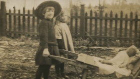
Edith Clayton, Buckingham Avenue
https://search.heritageburnaby.ca/link/archivedescription38879
- Repository
- City of Burnaby Archives
- Date
- 1915
- Collection/Fonds
- Peers Family and Hill Family fonds
- Description Level
- Item
- Physical Description
- 1 photograph : b&w ; 7.5 x 13 cm on page 14 x 17.5 cm (pasted in album)
- Scope and Content
- Photograph of Edith Clayton (left, with hat) and an unidentified girl pushing a cart holding a doll.
- Repository
- City of Burnaby Archives
- Date
- 1915
- Collection/Fonds
- Peers Family and Hill Family fonds
- Physical Description
- 1 photograph : b&w ; 7.5 x 13 cm on page 14 x 17.5 cm (pasted in album)
- Description Level
- Item
- Record No.
- 477-198
- Access Restriction
- No restrictions
- Reproduction Restriction
- No known restrictions
- Accession Number
- 2007-12
- Scope and Content
- Photograph of Edith Clayton (left, with hat) and an unidentified girl pushing a cart holding a doll.
- Subjects
- Toys - Dolls
- Transportation - Carts
- Names
- Clayton, Edith
- Media Type
- Photograph
- Notes
- Title based on caption accompanying photograph
- Geographic Access
- Buckingham Avenue
- Historic Neighbourhood
- Burnaby Lake (Historic Neighbourhood)
- Planning Study Area
- Morley-Buckingham Area
Images

![Edith Clayton in her yard, [1913] thumbnail](/media/hpo/_Data/_Archives_Images/_Unrestricted/477/477-203.jpg?width=280)
Edith Clayton in her yard
https://search.heritageburnaby.ca/link/archivedescription38884
- Repository
- City of Burnaby Archives
- Date
- [1913]
- Collection/Fonds
- Peers Family and Hill Family fonds
- Description Level
- Item
- Physical Description
- 1 photograph : b&w ; 5.5 x 10 cm on page 14 x 17.5 cm (pasted in album)
- Scope and Content
- Photograph of Edith Clayton standing amongst some flowers and trees on her family's property, Buckingham Avenue.
- Repository
- City of Burnaby Archives
- Date
- [1913]
- Collection/Fonds
- Peers Family and Hill Family fonds
- Physical Description
- 1 photograph : b&w ; 5.5 x 10 cm on page 14 x 17.5 cm (pasted in album)
- Description Level
- Item
- Record No.
- 477-203
- Access Restriction
- No restrictions
- Reproduction Restriction
- No known restrictions
- Accession Number
- 2007-12
- Scope and Content
- Photograph of Edith Clayton standing amongst some flowers and trees on her family's property, Buckingham Avenue.
- Subjects
- Plants - Flowers
- Names
- Clayton, Edith
- Media Type
- Photograph
- Notes
- Title based on caption accompanying photograph
- Geographic Access
- Buckingham Avenue
- Historic Neighbourhood
- Burnaby Lake (Historic Neighbourhood)
- Planning Study Area
- Morley-Buckingham Area
Images
![Edith Clayton in her yard, [1913] thumbnail](/media/hpo/_Data/_Archives_Images/_Unrestricted/477/477-203.jpg)
![Edith Clayton in yard of family home, [1913] thumbnail](/media/hpo/_Data/_Archives_Images/_Unrestricted/477/477-202.jpg?width=280)
Edith Clayton in yard of family home
https://search.heritageburnaby.ca/link/archivedescription38883
- Repository
- City of Burnaby Archives
- Date
- [1913]
- Collection/Fonds
- Peers Family and Hill Family fonds
- Description Level
- Item
- Physical Description
- 1 photograph : b&w ; 10 x 5.7 cm on page 14 x 17.5 cm (pasted in album)
- Scope and Content
- Photograph of Edith Clayton standing beside a table, outside the Clayton home on Buckingham Avenue in the Burnaby Lake area. The photograph was taken looking towards Deer Lake, which is partially visible in the background.
- Repository
- City of Burnaby Archives
- Date
- [1913]
- Collection/Fonds
- Peers Family and Hill Family fonds
- Physical Description
- 1 photograph : b&w ; 10 x 5.7 cm on page 14 x 17.5 cm (pasted in album)
- Description Level
- Item
- Record No.
- 477-202
- Access Restriction
- No restrictions
- Reproduction Restriction
- No known restrictions
- Accession Number
- 2007-12
- Scope and Content
- Photograph of Edith Clayton standing beside a table, outside the Clayton home on Buckingham Avenue in the Burnaby Lake area. The photograph was taken looking towards Deer Lake, which is partially visible in the background.
- Names
- Clayton, Edith
- Media Type
- Photograph
- Notes
- Title based on caption accompanying photograph
- Geographic Access
- Buckingham Avenue
- Deer Lake
- Historic Neighbourhood
- Burnaby Lake (Historic Neighbourhood)
- Planning Study Area
- Morley-Buckingham Area
Images
![Edith Clayton in yard of family home, [1913] thumbnail](/media/hpo/_Data/_Archives_Images/_Unrestricted/477/477-202.jpg)