Narrow Results By
Subject
- Accidents - Automobile Accidents 2
- Advertising Medium - Signs and Signboards 11
- Aerial Photographs 15
- Agricultural Tools and Equipment 9
- Agricultural Tools and Equipment - Gardening Equipment 1
- Agricultural Tools and Equipment - Plows 6
- Agriculture 2
- Agriculture - Crops 12
- Agriculture - Farms 109
- Agriculture - Fruit and Berries 9
- Agriculture - Poultry 1
- Agriculture - Ranches 1
![6664 Deer Lake Avenue lake frontage, [1979] thumbnail](/media/hpo/_Data/_Archives_Images/_Unrestricted/600/625-034.jpg?width=280)
6664 Deer Lake Avenue lake frontage
https://search.heritageburnaby.ca/link/archivedescription95606
- Repository
- City of Burnaby Archives
- Date
- [1979]
- Collection/Fonds
- City of Burnaby Archives photograph collection
- Description Level
- Item
- Physical Description
- 1 photograph (tiff)
- Scope and Content
- Photograph of the lake frontage at 6664 Deer Lake Avenue (formerly the F.J. Hart Estate "Avalon"; now Hart House). This photograph was taken prior to the City of Burnaby’s purchase of the home in 1979. Canada geese sit on a grassy lawn beneath trees on the edge of Deer Lake.
- Repository
- City of Burnaby Archives
- Date
- [1979]
- Collection/Fonds
- City of Burnaby Archives photograph collection
- Physical Description
- 1 photograph (tiff)
- Description Level
- Item
- Record No.
- 625-034
- Access Restriction
- No restrictions
- Reproduction Restriction
- Reproduce for fair dealing purposes only
- Accession Number
- 2021-10
- Scope and Content
- Photograph of the lake frontage at 6664 Deer Lake Avenue (formerly the F.J. Hart Estate "Avalon"; now Hart House). This photograph was taken prior to the City of Burnaby’s purchase of the home in 1979. Canada geese sit on a grassy lawn beneath trees on the edge of Deer Lake.
- Subjects
- Buildings - Heritage
- Animals - Birds
- Media Type
- Photograph
- Notes
- Title based on caption
- Caption was added during digitization.
- Geographic Access
- Deer Lake
- Street Address
- 6664 Deer Lake Avenue
- Historic Neighbourhood
- Burnaby Lake (Historic Neighbourhood)
- Planning Study Area
- Morley-Buckingham Area
Images
![6664 Deer Lake Avenue lake frontage, [1979] thumbnail](/media/hpo/_Data/_Archives_Images/_Unrestricted/600/625-034.jpg)
![6664 Deer Lake Avenue second floor bathroom (east), [1979] thumbnail](/media/hpo/_Data/_Archives_Images/_Unrestricted/600/625-024.jpg?width=280)
6664 Deer Lake Avenue second floor bathroom (east)
https://search.heritageburnaby.ca/link/archivedescription95596
- Repository
- City of Burnaby Archives
- Date
- [1979]
- Collection/Fonds
- City of Burnaby Archives photograph collection
- Description Level
- Item
- Physical Description
- 1 photograph (tiff)
- Scope and Content
- Photograph of the furnished east second floor bathroom in 6664 Deer Lake Avenue (formerly the F.J. Hart Estate "Avalon"; now Hart House). This photograph was taken prior to the City of Burnaby’s purchase of the home in 1979. The bathroom has blue carpeting, a small vanity, and a grey bathtub.
- Repository
- City of Burnaby Archives
- Date
- [1979]
- Collection/Fonds
- City of Burnaby Archives photograph collection
- Physical Description
- 1 photograph (tiff)
- Description Level
- Item
- Record No.
- 625-024
- Access Restriction
- No restrictions
- Reproduction Restriction
- Reproduce for fair dealing purposes only
- Accession Number
- 2021-10
- Scope and Content
- Photograph of the furnished east second floor bathroom in 6664 Deer Lake Avenue (formerly the F.J. Hart Estate "Avalon"; now Hart House). This photograph was taken prior to the City of Burnaby’s purchase of the home in 1979. The bathroom has blue carpeting, a small vanity, and a grey bathtub.
- Subjects
- Buildings - Heritage
- Media Type
- Photograph
- Notes
- Title based on caption
- Caption was added during digitization.
- Street Address
- 6664 Deer Lake Avenue
- Historic Neighbourhood
- Burnaby Lake (Historic Neighbourhood)
- Planning Study Area
- Morley-Buckingham Area
Images
![6664 Deer Lake Avenue second floor bathroom (east), [1979] thumbnail](/media/hpo/_Data/_Archives_Images/_Unrestricted/600/625-024.jpg)
![6664 Deer Lake Avenue second floor bedroom, [1979] thumbnail](/media/hpo/_Data/_Archives_Images/_Unrestricted/600/625-025.jpg?width=280)
6664 Deer Lake Avenue second floor bedroom
https://search.heritageburnaby.ca/link/archivedescription95597
- Repository
- City of Burnaby Archives
- Date
- [1979]
- Collection/Fonds
- City of Burnaby Archives photograph collection
- Description Level
- Item
- Physical Description
- 1 photograph (tiff)
- Scope and Content
- Photograph of a furnished second floor bedroom of 6664 Deer Lake Avenue (formerly the F.J. Hart Estate "Avalon"; now Hart House). This photograph was taken prior to the City of Burnaby’s purchase of the home in 1979. The bed has a floral bedspread and the caption notes the doors open to the balcony…
- Repository
- City of Burnaby Archives
- Date
- [1979]
- Collection/Fonds
- City of Burnaby Archives photograph collection
- Physical Description
- 1 photograph (tiff)
- Description Level
- Item
- Record No.
- 625-025
- Access Restriction
- No restrictions
- Reproduction Restriction
- Reproduce for fair dealing purposes only
- Accession Number
- 2021-10
- Scope and Content
- Photograph of a furnished second floor bedroom of 6664 Deer Lake Avenue (formerly the F.J. Hart Estate "Avalon"; now Hart House). This photograph was taken prior to the City of Burnaby’s purchase of the home in 1979. The bed has a floral bedspread and the caption notes the doors open to the balcony with a view of the pool.
- Subjects
- Buildings - Heritage
- Media Type
- Photograph
- Notes
- Title based on caption
- Caption was added during digitization.
- Street Address
- 6664 Deer Lake Avenue
- Historic Neighbourhood
- Burnaby Lake (Historic Neighbourhood)
- Planning Study Area
- Morley-Buckingham Area
Images
![6664 Deer Lake Avenue second floor bedroom, [1979] thumbnail](/media/hpo/_Data/_Archives_Images/_Unrestricted/600/625-025.jpg)
![6664 Deer Lake Avenue second floor bedroom, [1979] thumbnail](/media/hpo/_Data/_Archives_Images/_Unrestricted/600/625-026.jpg?width=280)
6664 Deer Lake Avenue second floor bedroom
https://search.heritageburnaby.ca/link/archivedescription95598
- Repository
- City of Burnaby Archives
- Date
- [1979]
- Collection/Fonds
- City of Burnaby Archives photograph collection
- Description Level
- Item
- Physical Description
- 1 photograph (tiff)
- Scope and Content
- Photograph of a second floor bedroom of 6664 Deer Lake Avenue (formerly the F.J. Hart Estate "Avalon"; now Hart House). This photograph was taken prior to the City of Burnaby’s purchase of the home in 1979. The photograph depicts a red-carpeted, unfurnished room with windows, and was taken facing n…
- Repository
- City of Burnaby Archives
- Date
- [1979]
- Collection/Fonds
- City of Burnaby Archives photograph collection
- Physical Description
- 1 photograph (tiff)
- Description Level
- Item
- Record No.
- 625-026
- Access Restriction
- No restrictions
- Reproduction Restriction
- Reproduce for fair dealing purposes only
- Accession Number
- 2021-10
- Scope and Content
- Photograph of a second floor bedroom of 6664 Deer Lake Avenue (formerly the F.J. Hart Estate "Avalon"; now Hart House). This photograph was taken prior to the City of Burnaby’s purchase of the home in 1979. The photograph depicts a red-carpeted, unfurnished room with windows, and was taken facing northeast.
- Subjects
- Buildings - Heritage
- Media Type
- Photograph
- Notes
- Title based on caption
- Caption was added during digitization.
- Street Address
- 6664 Deer Lake Avenue
- Historic Neighbourhood
- Burnaby Lake (Historic Neighbourhood)
- Planning Study Area
- Morley-Buckingham Area
Images
![6664 Deer Lake Avenue second floor bedroom, [1979] thumbnail](/media/hpo/_Data/_Archives_Images/_Unrestricted/600/625-026.jpg)
![6664 Deer Lake Avenue swimming pool, [1979] thumbnail](/media/hpo/_Data/_Archives_Images/_Unrestricted/600/625-029.jpg?width=280)
6664 Deer Lake Avenue swimming pool
https://search.heritageburnaby.ca/link/archivedescription95601
- Repository
- City of Burnaby Archives
- Date
- [1979]
- Collection/Fonds
- City of Burnaby Archives photograph collection
- Description Level
- Item
- Physical Description
- 1 photograph (tiff)
- Scope and Content
- Photograph of the swimming pool at 6664 Deer Lake Avenue (formerly the F.J. Hart Estate "Avalon"; now Hart House). This photograph was taken prior to the City of Burnaby’s purchase of the home in 1979. The photograph shows the fenced-in swimming pool, patio, and duck pond, with a view of Deer Lake …
- Repository
- City of Burnaby Archives
- Date
- [1979]
- Collection/Fonds
- City of Burnaby Archives photograph collection
- Physical Description
- 1 photograph (tiff)
- Description Level
- Item
- Record No.
- 625-029
- Access Restriction
- No restrictions
- Reproduction Restriction
- Reproduce for fair dealing purposes only
- Accession Number
- 2021-10
- Scope and Content
- Photograph of the swimming pool at 6664 Deer Lake Avenue (formerly the F.J. Hart Estate "Avalon"; now Hart House). This photograph was taken prior to the City of Burnaby’s purchase of the home in 1979. The photograph shows the fenced-in swimming pool, patio, and duck pond, with a view of Deer Lake in the background.
- Subjects
- Buildings - Heritage
- Media Type
- Photograph
- Notes
- Title based on content of item
- Caption was added during digitization.
- Geographic Access
- Deer Lake
- Street Address
- 6664 Deer Lake Avenue
- Historic Neighbourhood
- Burnaby Lake (Historic Neighbourhood)
- Planning Study Area
- Morley-Buckingham Area
Images
![6664 Deer Lake Avenue swimming pool, [1979] thumbnail](/media/hpo/_Data/_Archives_Images/_Unrestricted/600/625-029.jpg)
![6664 Deer Lake Avenue verandah, [1979] thumbnail](/media/hpo/_Data/_Archives_Images/_Unrestricted/600/625-031.jpg?width=280)
6664 Deer Lake Avenue verandah
https://search.heritageburnaby.ca/link/archivedescription95603
- Repository
- City of Burnaby Archives
- Date
- [1979]
- Collection/Fonds
- City of Burnaby Archives photograph collection
- Description Level
- Item
- Physical Description
- 1 photograph (tiff)
- Scope and Content
- Photograph of the verandah at 6664 Deer Lake Avenue (formerly the F.J. Hart Estate "Avalon"; now Hart House). This photograph was taken prior to the City of Burnaby’s purchase of the home in 1979. The photograph depicts the enclosed verandah, furnished with patio furniture, and some of its view of …
- Repository
- City of Burnaby Archives
- Date
- [1979]
- Collection/Fonds
- City of Burnaby Archives photograph collection
- Physical Description
- 1 photograph (tiff)
- Description Level
- Item
- Record No.
- 625-031
- Access Restriction
- No restrictions
- Reproduction Restriction
- Reproduce for fair dealing purposes only
- Accession Number
- 2021-10
- Scope and Content
- Photograph of the verandah at 6664 Deer Lake Avenue (formerly the F.J. Hart Estate "Avalon"; now Hart House). This photograph was taken prior to the City of Burnaby’s purchase of the home in 1979. The photograph depicts the enclosed verandah, furnished with patio furniture, and some of its view of the swimming pool and of Deer Lake.
- Subjects
- Buildings - Heritage
- Media Type
- Photograph
- Notes
- Title based on caption
- Caption was added during digitization.
- Geographic Access
- Deer Lake
- Street Address
- 6664 Deer Lake Avenue
- Historic Neighbourhood
- Burnaby Lake (Historic Neighbourhood)
- Planning Study Area
- Morley-Buckingham Area
Images
![6664 Deer Lake Avenue verandah, [1979] thumbnail](/media/hpo/_Data/_Archives_Images/_Unrestricted/600/625-031.jpg)
![AAA Bantam Provincial Hockey Championships game, [2002] thumbnail](/media/hpo/_Data/_Archives_Images/_Unrestricted/535/535-2309.jpg?width=280)
AAA Bantam Provincial Hockey Championships game
https://search.heritageburnaby.ca/link/archivedescription96704
- Repository
- City of Burnaby Archives
- Date
- [2002]
- Collection/Fonds
- Burnaby NewsLeader photograph collection
- Description Level
- Item
- Physical Description
- 1 photograph (tiff) : col.
- Scope and Content
- Photograph of two unidentified hockey players in action during an AAA Bantam Provincial Hockey Championships game between the Burnaby Winter Club and the Prince George Cougars.
- Repository
- City of Burnaby Archives
- Date
- [2002]
- Collection/Fonds
- Burnaby NewsLeader photograph collection
- Physical Description
- 1 photograph (tiff) : col.
- Description Level
- Item
- Record No.
- 535-2309
- Access Restriction
- No restrictions
- Reproduction Restriction
- No restrictions
- Accession Number
- 2018-12
- Scope and Content
- Photograph of two unidentified hockey players in action during an AAA Bantam Provincial Hockey Championships game between the Burnaby Winter Club and the Prince George Cougars.
- Subjects
- Sports - Ice Hockey
- Persons - Adolescents
- Media Type
- Photograph
- Photographer
- Bartel, Mario
- Notes
- Title based on caption
- Collected by editorial for use in a March 2002 issue of the Burnaby NewsLeader
- Caption from metadata: "A Burnaby Winter Club forward heads up ice past the check of a Prince George Cougars' defender in early-round action at the AAA Bantam Provincial Hockey Championships, at Copeland Arena."
- Geographic Access
- Burnaby Lake Sports Complex
- Kensington Avenue
- Street Address
- 3676 Kensington Avenue
- Historic Neighbourhood
- Burnaby Lake (Historic Neighbourhood)
- Planning Study Area
- Ardingley-Sprott Area
Images
![AAA Bantam Provincial Hockey Championships game, [2002] thumbnail](/media/hpo/_Data/_Archives_Images/_Unrestricted/535/535-2309.jpg)
![Aaron Lau throwing a javelin, [1999] thumbnail](/media/hpo/_Data/_Archives_Images/_Unrestricted/535/535-3160.jpg?width=280)
Aaron Lau throwing a javelin
https://search.heritageburnaby.ca/link/archivedescription98080
- Repository
- City of Burnaby Archives
- Date
- [1999]
- Collection/Fonds
- Burnaby NewsLeader photograph collection
- Description Level
- Item
- Physical Description
- 1 photograph (tiff) : col.
- Scope and Content
- Photograph of Aaron Lau, a Moscrop Secondary School student, about to throw a javelin during a Burnaby-New Westminster high school track and field meet at Burnaby Central.
- Repository
- City of Burnaby Archives
- Date
- [1999]
- Collection/Fonds
- Burnaby NewsLeader photograph collection
- Physical Description
- 1 photograph (tiff) : col.
- Description Level
- Item
- Record No.
- 535-3160
- Access Restriction
- No restrictions
- Reproduction Restriction
- No restrictions
- Accession Number
- 2018-12
- Scope and Content
- Photograph of Aaron Lau, a Moscrop Secondary School student, about to throw a javelin during a Burnaby-New Westminster high school track and field meet at Burnaby Central.
- Subjects
- Sports
- Persons - Students
- Media Type
- Photograph
- Notes
- Title based on caption
- Collected by editorial for use in a May 1999 issue of the Burnaby NewsLeader
- Caption from metadata: "Moscrop's Aaron Lau rears back in the boys' javelin competition at the Burnaby-New West high school track and field meet at Burnaby Central."
- Geographic Access
- Canada Way
- Street Address
- 4939 Canada Way
- Historic Neighbourhood
- Burnaby Lake (Historic Neighbourhood)
- Planning Study Area
- Douglas-Gilpin Area
Images
![Aaron Lau throwing a javelin, [1999] thumbnail](/media/hpo/_Data/_Archives_Images/_Unrestricted/535/535-3160.jpg)
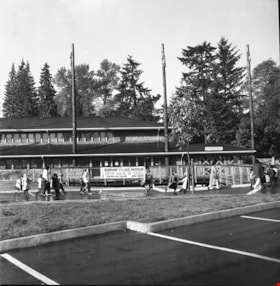
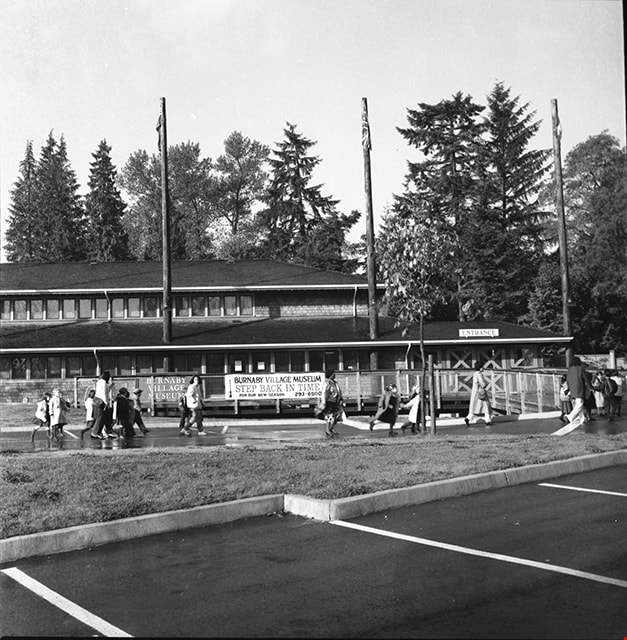
Adminstration building and entrance to Burnaby Village Museum
https://search.heritageburnaby.ca/link/museumdescription17505
- Repository
- Burnaby Village Museum
- Date
- 1990
- Collection/Fonds
- Burnaby Village Museum fonds
- Description Level
- Item
- Physical Description
- 1 photograph : b&w negative ; 6 x 6 cm
- Scope and Content
- Photograph of Burnaby Village Museum adminstration building, parking lot and entrance. A group of visitors are walking through the parking lot towards the entrance.
- Repository
- Burnaby Village Museum
- Collection/Fonds
- Burnaby Village Museum fonds
- Series
- Museum photographs series
- Description Level
- Item
- Physical Description
- 1 photograph : b&w negative ; 6 x 6 cm
- Scope and Content
- Photograph of Burnaby Village Museum adminstration building, parking lot and entrance. A group of visitors are walking through the parking lot towards the entrance.
- Subjects
- Buildings - Civic - Museums
- Names
- Burnaby Village Museum
- Geographic Access
- Deer Lake Avenue
- Street Address
- 6501 Deer Lake Avenue
- Accession Code
- BV019.2.66
- Access Restriction
- No restrictions
- Reproduction Restriction
- No known restrictions
- Date
- 1990
- Media Type
- Photograph
- Historic Neighbourhood
- Burnaby Lake (Historic Neighbourhood)
- Scan Resolution
- 1200
- Scan Date
- 2021-09-29
- Photographer
- Stevens, Colin
- Notes
- Title based on contents of photograph
- Photograph from negative roll "P90-19"
Images

Adults and children at Deer Lake Park
https://search.heritageburnaby.ca/link/archivedescription59007
- Repository
- City of Burnaby Archives
- Date
- ca.1983
- Collection/Fonds
- Columbian Newspaper collection
- Description Level
- Item
- Physical Description
- 1 photograph : b&w ; 20.5 x 25.5 cm
- Scope and Content
- Photograph of adults and children having a picnic on the beach at Deer Lake Park.
- Repository
- City of Burnaby Archives
- Date
- ca.1983
- Collection/Fonds
- Columbian Newspaper collection
- Physical Description
- 1 photograph : b&w ; 20.5 x 25.5 cm
- Description Level
- Item
- Record No.
- 480-1416
- Access Restriction
- No restrictions
- Reproduction Restriction
- Reproduce for fair dealing purposes only
- Accession Number
- 2009-01
- Scope and Content
- Photograph of adults and children having a picnic on the beach at Deer Lake Park.
- Subjects
- Recreational Activities - Picnics
- Geographic Features - Lakes and Ponds
- Geographic Features - Beaches
- Persons - Children
- Media Type
- Photograph
- Photographer
- King, Basil
- Notes
- Title based on contents of photograph
- Photographer's stamp on verso
- Note on verso reads: "PMT 120% / page 10 / Burnaby / Today"
- Geographic Access
- Deer Lake Park
- Historic Neighbourhood
- Burnaby Lake (Historic Neighbourhood)
- Planning Study Area
- Douglas-Gilpin Area
Images

Aerial photograph of Burnaby
https://search.heritageburnaby.ca/link/archivedescription84891
- Repository
- City of Burnaby Archives
- Date
- 1963
- Collection/Fonds
- Allan Amundsen collection
- Description Level
- Item
- Physical Description
- 1 photograph : b&w ; 22.5 x 22.5 cm
- Scope and Content
- Aerial photograph of Burnaby north of Lougheed Highway.
- Repository
- City of Burnaby Archives
- Date
- 1963
- Collection/Fonds
- Allan Amundsen collection
- Physical Description
- 1 photograph : b&w ; 22.5 x 22.5 cm
- Description Level
- Item
- Record No.
- 561-012
- Access Restriction
- In Archives only
- Reproduction Restriction
- No reproduction permitted
- Accession Number
- 2014-08
- Scope and Content
- Aerial photograph of Burnaby north of Lougheed Highway.
- Media Type
- Photograph
- Photographer
- Province of British Columbia
- Notes
- Title based on contents of photograph
- This photo is indentified as BC5061:117 and connects with B.C. air photograph BC5061:118 to the east
- Historic Neighbourhood
- Burnaby Lake (Historic Neighbourhood)
- Planning Study Area
- Parkcrest-Aubrey Area
- Ardingley-Sprott Area
Aerial photograph of Burnaby
https://search.heritageburnaby.ca/link/archivedescription84892
- Repository
- City of Burnaby Archives
- Date
- 1963
- Collection/Fonds
- Allan Amundsen collection
- Description Level
- Item
- Physical Description
- 1 photograph : b&w ; 22.5 x 22.5 cm
- Scope and Content
- Aerial photograph of Burnaby north of Lougheed Highway.
- Repository
- City of Burnaby Archives
- Date
- 1963
- Collection/Fonds
- Allan Amundsen collection
- Physical Description
- 1 photograph : b&w ; 22.5 x 22.5 cm
- Description Level
- Item
- Record No.
- 561-013
- Access Restriction
- In Archives only
- Reproduction Restriction
- No reproduction permitted
- Accession Number
- 2014-08
- Scope and Content
- Aerial photograph of Burnaby north of Lougheed Highway.
- Subjects
- Aerial Photographs
- Media Type
- Photograph
- Photographer
- Province of British Columbia
- Notes
- Title based on contents of photograph
- This photo is indentified as BC5061:118 and connects with B.C. air photograph BC5061:117 to the west and BC5061:119 to the east
- Historic Neighbourhood
- Burnaby Lake (Historic Neighbourhood)
- Lozells (Historic Neighbourhood)
- Planning Study Area
- Parkcrest-Aubrey Area
- Ardingley-Sprott Area
- Sperling-Broadway Area
- Government Road Area
Aerial photograph of Burnaby
https://search.heritageburnaby.ca/link/archivedescription84903
- Repository
- City of Burnaby Archives
- Date
- 1963
- Collection/Fonds
- Allan Amundsen collection
- Description Level
- Item
- Physical Description
- 1 photograph : b&w ; 22.5 x 22.5 cm
- Scope and Content
- Aerial photograph of Burnaby with the Trans Canada Highway running through and the Forest Lawn Cemetery to the south.
- Repository
- City of Burnaby Archives
- Date
- 1963
- Collection/Fonds
- Allan Amundsen collection
- Physical Description
- 1 photograph : b&w ; 22.5 x 22.5 cm
- Description Level
- Item
- Record No.
- 561-024
- Access Restriction
- In Archives only
- Reproduction Restriction
- No reproduction permitted
- Accession Number
- 2014-08
- Scope and Content
- Aerial photograph of Burnaby with the Trans Canada Highway running through and the Forest Lawn Cemetery to the south.
- Subjects
- Aerial Photographs
- Media Type
- Photograph
- Photographer
- Province of British Columbia
- Notes
- Title based on contents of photograph
- This photo is indentified as BC5062:27 and connects with B.C. air photograph BC5061:26 to the east
- Historic Neighbourhood
- Burnaby Lake (Historic Neighbourhood)
- Planning Study Area
- Douglas-Gilpin Area
- Ardingley-Sprott Area
- Dawson-Delta Area
Aerial photograph of Burnaby
https://search.heritageburnaby.ca/link/archivedescription84907
- Repository
- City of Burnaby Archives
- Date
- 1963
- Collection/Fonds
- Allan Amundsen collection
- Description Level
- Item
- Physical Description
- 1 photograph : b&w ; 22.5 x 22.5 cm
- Scope and Content
- Aerial photograph of Burnaby with the Trans Canada Highway running from through and Burnaby Lake in the south east corner.
- Repository
- City of Burnaby Archives
- Date
- 1963
- Collection/Fonds
- Allan Amundsen collection
- Physical Description
- 1 photograph : b&w ; 22.5 x 22.5 cm
- Description Level
- Item
- Record No.
- 561-025
- Access Restriction
- In Archives only
- Reproduction Restriction
- No reproduction permitted
- Accession Number
- 2014-08
- Scope and Content
- Aerial photograph of Burnaby with the Trans Canada Highway running from through and Burnaby Lake in the south east corner.
- Subjects
- Aerial Photographs
- Media Type
- Photograph
- Photographer
- Province of British Columbia
- Notes
- Title based on contents of photograph
- This photo is indentified as BC5062:26 and connects with B.C. air photograph BC5062:27 to the west and B.C. air photograph BC5062:25 to the east
- Historic Neighbourhood
- Burnaby Lake (Historic Neighbourhood)
- Planning Study Area
- Douglas-Gilpin Area
- Ardingley-Sprott Area
- Burnaby Lake Area
Aerial photograph of Burnaby Lake Area
https://search.heritageburnaby.ca/link/archivedescription84908
- Repository
- City of Burnaby Archives
- Date
- 1963
- Collection/Fonds
- Allan Amundsen collection
- Description Level
- Item
- Physical Description
- 1 photograph : b&w ; 22.5 x 22.5 cm
- Scope and Content
- Aerial photograph of Burnaby with Lougheed Highway in the north west corner, the Trans Canada Highway in the south east corner and Burnaby Lake appearing from the west.
- Repository
- City of Burnaby Archives
- Date
- 1963
- Collection/Fonds
- Allan Amundsen collection
- Physical Description
- 1 photograph : b&w ; 22.5 x 22.5 cm
- Description Level
- Item
- Record No.
- 561-026
- Access Restriction
- In Archives only
- Reproduction Restriction
- No reproduction permitted
- Accession Number
- 2014-08
- Scope and Content
- Aerial photograph of Burnaby with Lougheed Highway in the north west corner, the Trans Canada Highway in the south east corner and Burnaby Lake appearing from the west.
- Subjects
- Aerial Photographs
- Media Type
- Photograph
- Photographer
- Province of British Columbia
- Notes
- Title based on contents of photograph
- This photo is indentified as BC5062:25 and connects with B.C. air photograph BC5062:26 to the west and B.C. air photograph BC5062:24 to the east
- Historic Neighbourhood
- Burnaby Lake (Historic Neighbourhood)
- Lozells (Historic Neighbourhood)
- Planning Study Area
- Douglas-Gilpin Area
- Sperling-Broadway Area
- Government Road Area
- Burnaby Lake Area
Aerial photograph of Burnaby Lake Area
https://search.heritageburnaby.ca/link/archivedescription84909
- Repository
- City of Burnaby Archives
- Date
- 1963
- Collection/Fonds
- Allan Amundsen collection
- Description Level
- Item
- Physical Description
- 1 photograph : b&w ; 22.5 x 22.5 cm
- Scope and Content
- Aerial photograph of Burnaby with Lougheed Highway to the north and Burnaby Lake to the south.
- Repository
- City of Burnaby Archives
- Date
- 1963
- Collection/Fonds
- Allan Amundsen collection
- Physical Description
- 1 photograph : b&w ; 22.5 x 22.5 cm
- Description Level
- Item
- Record No.
- 561-027
- Access Restriction
- In Archives only
- Reproduction Restriction
- No reproduction permitted
- Accession Number
- 2014-08
- Scope and Content
- Aerial photograph of Burnaby with Lougheed Highway to the north and Burnaby Lake to the south.
- Subjects
- Aerial Photographs
- Media Type
- Photograph
- Photographer
- Province of British Columbia
- Notes
- Title based on contents of photograph
- This photo is indentified as BC5062:24 and connects with B.C. air photograph BC5062:25 to the west and B.C. air photograph BC5062:23 to the east
- Historic Neighbourhood
- Burnaby Lake (Historic Neighbourhood)
- Lozells (Historic Neighbourhood)
- Planning Study Area
- Douglas-Gilpin Area
- Sperling-Broadway Area
- Government Road Area
- Burnaby Lake Area
Aerial photograph of Burnaby Lake Area
https://search.heritageburnaby.ca/link/archivedescription84910
- Repository
- City of Burnaby Archives
- Date
- 1963
- Collection/Fonds
- Allan Amundsen collection
- Description Level
- Item
- Physical Description
- 1 photograph : b&w ; 22.5 x 22.5 cm
- Scope and Content
- Aerial photograph of Burnaby with Burnaby Lake to the south and Broadway to the north.
- Repository
- City of Burnaby Archives
- Date
- 1963
- Collection/Fonds
- Allan Amundsen collection
- Physical Description
- 1 photograph : b&w ; 22.5 x 22.5 cm
- Description Level
- Item
- Record No.
- 561-028
- Access Restriction
- In Archives only
- Reproduction Restriction
- No reproduction permitted
- Accession Number
- 2014-08
- Scope and Content
- Aerial photograph of Burnaby with Burnaby Lake to the south and Broadway to the north.
- Subjects
- Aerial Photographs
- Media Type
- Photograph
- Photographer
- Province of British Columbia
- Notes
- Title based on contents of photograph
- This photo is indentified as BC5062:23 and connects with B.C. air photograph BC5062:24 to the west and B.C. air photograph BC5062:22 to the east
- Historic Neighbourhood
- Burnaby Lake (Historic Neighbourhood)
- Lozells (Historic Neighbourhood)
- Planning Study Area
- Lake City Area
- Government Road Area
- Burnaby Lake Area
![Aerial photograph of Douglas Road and Sperling Avenue, [1938] thumbnail](/media/hpo/_Data/_BVM_Images/1990/199200470001.jpg?width=280)
Aerial photograph of Douglas Road and Sperling Avenue
https://search.heritageburnaby.ca/link/museumdescription1165
- Repository
- Burnaby Village Museum
- Date
- [1938]
- Collection/Fonds
- Burnaby Village Museum Photograph collection
- Description Level
- Item
- Physical Description
- 1 photograph : b&w ; 19 x 24 cm
- Scope and Content
- Aerial photograph of the area surrounding Douglas Road and Sperling Avenue.
- Repository
- Burnaby Village Museum
- Collection/Fonds
- Burnaby Village Museum Photograph collection
- Description Level
- Item
- Physical Description
- 1 photograph : b&w ; 19 x 24 cm
- Scope and Content
- Aerial photograph of the area surrounding Douglas Road and Sperling Avenue.
- Subjects
- Aerial Photographs
- Geographic Access
- Douglas Road
- Sperling Avenue
- Accession Code
- BV992.47.1
- Access Restriction
- No restrictions
- Date
- [1938]
- Media Type
- Photograph
- Historic Neighbourhood
- Burnaby Lake (Historic Neighbourhood)
- Planning Study Area
- Morley-Buckingham Area
- Scan Resolution
- 600
- Scan Date
- 01-Jun-09
- Scale
- 100
- Notes
- Title based on contents of photograph
- Notes on verso of photograph read: "Burnaby Image Bank #532" and "DOUGLAS ROAD AND SPERLING c. 1938"
- Stamp on verso of photograph reads: "Copyright Simon Fraser/ University Archives"
Images
![Aerial photograph of Douglas Road and Sperling Avenue, [1938] thumbnail](/media/hpo/_Data/_BVM_Images/1990/199200470001.jpg)
![Aerial photograph of the Burnaby Village area, [1946] (date of original), copied 1991 thumbnail](/media/hpo/_Data/_Archives_Images/_Unrestricted/370/370-532.jpg?width=280)
Aerial photograph of the Burnaby Village area
https://search.heritageburnaby.ca/link/archivedescription37945
- Repository
- City of Burnaby Archives
- Date
- [1946] (date of original), copied 1991
- Collection/Fonds
- Burnaby Historical Society fonds
- Description Level
- Item
- Physical Description
- 1 photograph : b&w ; 3.5 x 4.4 cm print on contact sheet 20.5 x 26.7 cm
- Scope and Content
- Aerial photograph of the Sperling Avenue/Douglas Road Burnaby Village area.
- Repository
- City of Burnaby Archives
- Date
- [1946] (date of original), copied 1991
- Collection/Fonds
- Burnaby Historical Society fonds
- Subseries
- Burnaby Image Bank subseries
- Physical Description
- 1 photograph : b&w ; 3.5 x 4.4 cm print on contact sheet 20.5 x 26.7 cm
- Description Level
- Item
- Record No.
- 370-532
- Access Restriction
- No restrictions
- Reproduction Restriction
- No known restrictions
- Accession Number
- BHS1999-03
- Scope and Content
- Aerial photograph of the Sperling Avenue/Douglas Road Burnaby Village area.
- Subjects
- Aerial Photographs
- Media Type
- Photograph
- Notes
- Title based on contents of photograph
- 1 b&w copy negative accompanying
- Negative has a pink cast
- Geographic Access
- Douglas Road
- Sperling Avenue
- Canada Way
- Historic Neighbourhood
- Burnaby Lake (Historic Neighbourhood)
Images
![Aerial photograph of the Burnaby Village area, [1946] (date of original), copied 1991 thumbnail](/media/hpo/_Data/_Archives_Images/_Unrestricted/370/370-532.jpg)
![Aerial spraying over Burnaby Lake, [2000] thumbnail](/media/hpo/_Data/_Archives_Images/_Unrestricted/535/535-2408.jpg?width=280)
Aerial spraying over Burnaby Lake
https://search.heritageburnaby.ca/link/archivedescription96850
- Repository
- City of Burnaby Archives
- Date
- [2000]
- Collection/Fonds
- Burnaby NewsLeader photograph collection
- Description Level
- Item
- Physical Description
- 1 photograph (tiff) : b&w
- Scope and Content
- Photograph of an airplane spraying pesticides over Burnaby Lake to eradicate European Gypsy moths.
- Repository
- City of Burnaby Archives
- Date
- [2000]
- Collection/Fonds
- Burnaby NewsLeader photograph collection
- Physical Description
- 1 photograph (tiff) : b&w
- Description Level
- Item
- Record No.
- 535-2408
- Access Restriction
- No restrictions
- Reproduction Restriction
- No restrictions
- Accession Number
- 2018-12
- Scope and Content
- Photograph of an airplane spraying pesticides over Burnaby Lake to eradicate European Gypsy moths.
- Media Type
- Photograph
- Notes
- Title based on original file name
- Collected by editorial for use in a May 2000 issue of the Burnaby NewsLeader
- Geographic Access
- Burnaby Lake
- Historic Neighbourhood
- Burnaby Lake (Historic Neighbourhood)
- Planning Study Area
- Douglas-Gilpin Area
Images
![Aerial spraying over Burnaby Lake, [2000] thumbnail](/media/hpo/_Data/_Archives_Images/_Unrestricted/535/535-2408.jpg)