Cunningham house kitchen
https://search.heritageburnaby.ca/link/museumdescription17975
- Repository
- Burnaby Village Museum
- Date
- Jan. 1991
- Collection/Fonds
- Burnaby Village Museum Photograph collection
- Description Level
- Item
- Physical Description
- 1 photograph : col. negative ; 35 mm
- Scope and Content
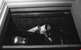
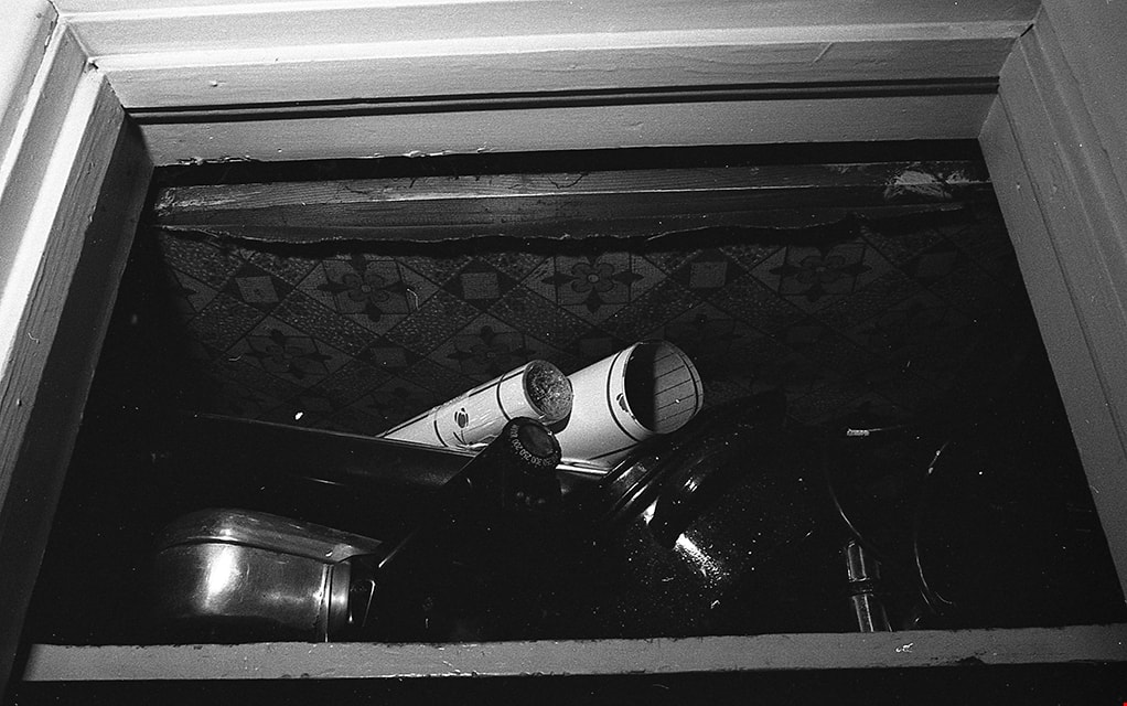
- Photograph of interior of Cunningham house kitchen located at 3555 Douglas Road, Burnaby. View of top shelf inside an open kitchen cupboard holding cookware, bakeware and rolls of wallpaper. The house was built in 1923 on the property owned by Fred and Edna Cunningham. The Cunningham house was desi…
- Repository
- Burnaby Village Museum
- Collection/Fonds
- Burnaby Village Museum Photograph collection
- Description Level
- Item
- Physical Description
- 1 photograph : col. negative ; 35 mm
- Scope and Content
- Photograph of interior of Cunningham house kitchen located at 3555 Douglas Road, Burnaby. View of top shelf inside an open kitchen cupboard holding cookware, bakeware and rolls of wallpaper. The house was built in 1923 on the property owned by Fred and Edna Cunningham. The Cunningham house was designated as a heritage building in 1996.
- Geographic Access
- Douglas Road
- Street Address
- 3555 Douglas Road
- Accession Code
- BV022.3.39
- Access Restriction
- No restrictions
- Reproduction Restriction
- No known restrictions
- Date
- Jan. 1991
- Media Type
- Photograph
- Historic Neighbourhood
- Burnaby Lake (Historic Neighbourhood)
- Planning Study Area
- Douglas-Gilpin Area
- Scan Resolution
- 2400
- Scan Date
- 2021-08-24
- Photographer
- Stevens, Colin
- Notes
- Title based on contents of photograph
- Photograph from Roll P92-5, negative 21
- 1 b&w. print accompanying
- Note in black ink on verso of accompanying photograph print reads: "P92-5-21"
Images
Cunningham house kitchen
https://search.heritageburnaby.ca/link/museumdescription17976
- Repository
- Burnaby Village Museum
- Date
- Jan. 1991
- Collection/Fonds
- Burnaby Village Museum Photograph collection
- Description Level
- Item
- Physical Description
- 1 photograph : col. negative ; 35 mm
- Scope and Content
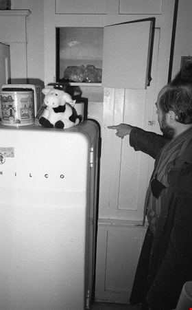
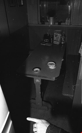
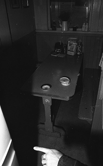
- Photograph of interior of Cunningham house kitchen with refrigerator and built in cupboards located at 3555 Douglas Road, Burnaby. Burnaby Village Museum Assistant Curator, Steve Barrett is pointing towards built in cupboards behind refrigerator. The house was built in 1923 on the property owned by…
- Repository
- Burnaby Village Museum
- Collection/Fonds
- Burnaby Village Museum Photograph collection
- Description Level
- Item
- Physical Description
- 1 photograph : col. negative ; 35 mm
- Scope and Content
- Photograph of interior of Cunningham house kitchen with refrigerator and built in cupboards located at 3555 Douglas Road, Burnaby. Burnaby Village Museum Assistant Curator, Steve Barrett is pointing towards built in cupboards behind refrigerator. The house was built in 1923 on the property owned by Fred and Edna Cunningham. The Cunningham house was designated as a heritage building in 1996.
- Geographic Access
- Douglas Road
- Street Address
- 3555 Douglas Road
- Accession Code
- BV022.3.40
- Access Restriction
- No restrictions
- Reproduction Restriction
- No known restrictions
- Date
- Jan. 1991
- Media Type
- Photograph
- Historic Neighbourhood
- Burnaby Lake (Historic Neighbourhood)
- Planning Study Area
- Douglas-Gilpin Area
- Scan Resolution
- 2400
- Scan Date
- 2021-08-24
- Photographer
- Stevens, Colin
- Notes
- Title based on contents of photograph
- Photograph from Roll P92-5, negative 22
- 1 b&w. print accompanying
- Note in black ink on verso of accompanying photograph print reads: "P92-5-22"
Images

Cunningham house kitchen
https://search.heritageburnaby.ca/link/museumdescription17977
- Repository
- Burnaby Village Museum
- Date
- Jan. 1991
- Collection/Fonds
- Burnaby Village Museum Photograph collection
- Description Level
- Item
- Physical Description
- 1 photograph : col. negative ; 35 mm
- Scope and Content
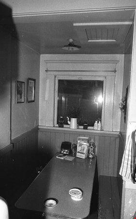
- Photograph of interior of Cunningham house kitchen located at 3555 Douglas Road, Burnaby. View of dining nook and kitchen window. The house was built in 1923 on the property owned by Fred and Edna Cunningham. The Cunningham house was designated as a heritage building in 1996.
- Repository
- Burnaby Village Museum
- Collection/Fonds
- Burnaby Village Museum Photograph collection
- Description Level
- Item
- Physical Description
- 1 photograph : col. negative ; 35 mm
- Scope and Content
- Photograph of interior of Cunningham house kitchen located at 3555 Douglas Road, Burnaby. View of dining nook and kitchen window. The house was built in 1923 on the property owned by Fred and Edna Cunningham. The Cunningham house was designated as a heritage building in 1996.
- Geographic Access
- Douglas Road
- Street Address
- 3555 Douglas Road
- Accession Code
- BV022.3.41
- Access Restriction
- No restrictions
- Reproduction Restriction
- No known restrictions
- Date
- Jan. 1991
- Media Type
- Photograph
- Historic Neighbourhood
- Burnaby Lake (Historic Neighbourhood)
- Planning Study Area
- Douglas-Gilpin Area
- Scan Resolution
- 2400
- Scan Date
- 2021-08-24
- Photographer
- Stevens, Colin
- Notes
- Title based on contents of photograph
- Photograph from Roll P92-5, negative 23
Images

Cunningham house kitchen
https://search.heritageburnaby.ca/link/museumdescription17978
- Repository
- Burnaby Village Museum
- Date
- Jan. 1991
- Collection/Fonds
- Burnaby Village Museum Photograph collection
- Description Level
- Item
- Physical Description
- 1 photograph : col. negative ; 35 mm
- Scope and Content
- Photograph of interior of Cunningham house kitchen located at 3555 Douglas Road, Burnaby. View of dining nook and kitchen window. The house was built in 1923 on the property owned by Fred and Edna Cunningham. The Cunningham house was designated as a heritage building in 1996.
- Repository
- Burnaby Village Museum
- Collection/Fonds
- Burnaby Village Museum Photograph collection
- Description Level
- Item
- Physical Description
- 1 photograph : col. negative ; 35 mm
- Scope and Content
- Photograph of interior of Cunningham house kitchen located at 3555 Douglas Road, Burnaby. View of dining nook and kitchen window. The house was built in 1923 on the property owned by Fred and Edna Cunningham. The Cunningham house was designated as a heritage building in 1996.
- Geographic Access
- Douglas Road
- Street Address
- 3555 Douglas Road
- Accession Code
- BV022.3.42
- Access Restriction
- No restrictions
- Reproduction Restriction
- No known restrictions
- Date
- Jan. 1991
- Media Type
- Photograph
- Historic Neighbourhood
- Burnaby Lake (Historic Neighbourhood)
- Planning Study Area
- Douglas-Gilpin Area
- Scan Resolution
- 2400
- Scan Date
- 2021-08-24
- Photographer
- Stevens, Colin
- Notes
- Title based on contents of photograph
- Photograph from Roll P92-5, negative 24
Images

Looking southwest from corner of Douglas Road and Dominion Street
https://search.heritageburnaby.ca/link/archivedescription91877
- Repository
- City of Burnaby Archives
- Date
- 1978
- Collection/Fonds
- Small family fonds
- Description Level
- Item
- Physical Description
- 1 photograph : col. ; 9 cm x 13 cm
- Scope and Content
- Photograph of trees and a telephone pole situated at the southwest corner of Douglas Road and Dominion Street. The large oak, hemlock, and fir to the left of the telephone pole were planted as part of the original landscaping of the Roberts' property in the 1920s. The photograph was taken from th…
- Repository
- City of Burnaby Archives
- Date
- 1978
- Collection/Fonds
- Small family fonds
- Physical Description
- 1 photograph : col. ; 9 cm x 13 cm
- Description Level
- Item
- Record No.
- 620-058
- Access Restriction
- No restrictions
- Reproduction Restriction
- No reproduction permitted
- Accession Number
- 2017-01
- Scope and Content
- Photograph of trees and a telephone pole situated at the southwest corner of Douglas Road and Dominion Street. The large oak, hemlock, and fir to the left of the telephone pole were planted as part of the original landscaping of the Roberts' property in the 1920s. The photograph was taken from the Douglas Road and Dominion Street intersection.
- Media Type
- Photograph
- Notes
- Transcribed title
- Title transcribed from donor's notes
- Note in blue ink on verso of photograph reads: "P.20"
- Note in blue ink on verso of photograph reads: "Photo 1978"
- Note in black ink on verso of photograph reads: "Looking at S.W. corner of Douglas Rd and Dominion Street, from intersection / Oak tree, hemlock tree, and fir tree, Japanese Plum Tree"
- The oak tree is the same tree as in photographs 620-007, 620-014, 620-015, and 620-016
- Geographic Access
- Dominion Street
- Douglas Road
- Historic Neighbourhood
- Burnaby Lake (Historic Neighbourhood)
- Planning Study Area
- Ardingley-Sprott Area
Images


Douglas Road School Crossing
https://search.heritageburnaby.ca/link/archivedescription93646
- Repository
- City of Burnaby Archives
- Date
- November 20, 1977
- Collection/Fonds
- Burnaby Public Library Contemporary Visual Archive Project
- Description Level
- Item
- Physical Description
- 1 photograph : b&w ; 12.5 x 17.5 cm
- Scope and Content
- Photograph of the front exterior of Douglas Road Elementary School. The photograph is taken from across the intersection of Douglas Road and Canada Way, facing west. The front of the school is mostly obscured by trees.
- Repository
- City of Burnaby Archives
- Date
- November 20, 1977
- Collection/Fonds
- Burnaby Public Library Contemporary Visual Archive Project
- Physical Description
- 1 photograph : b&w ; 12.5 x 17.5 cm
- Description Level
- Item
- Record No.
- 556-603
- Access Restriction
- No restrictions
- Reproduction Restriction
- Reproduce for fair dealing purposes only
- Accession Number
- 2017-57
- Scope and Content
- Photograph of the front exterior of Douglas Road Elementary School. The photograph is taken from across the intersection of Douglas Road and Canada Way, facing west. The front of the school is mostly obscured by trees.
- Subjects
- Buildings - Schools
- Names
- Douglas Road School
- Media Type
- Photograph
- Photographer
- Chapman, Fred
- Notes
- Title taken from project information form
- Accompanied by a project information form and 1 photograph (b&w negative ; 9.5 x 12.5 cm)
- BPL no. 53
- Geographic Access
- Douglas Road
- Canada Way
- Street Address
- 4861 Canada Way
- Historic Neighbourhood
- Burnaby Lake (Historic Neighbourhood)
- Planning Study Area
- Douglas-Gilpin Area
Images

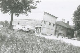
Hilltop Grocery
https://search.heritageburnaby.ca/link/archivedescription79116
- Repository
- City of Burnaby Archives
- Date
- October, 1976
- Collection/Fonds
- Burnaby Public Library Contemporary Visual Archive Project
- Description Level
- Item
- Physical Description
- 1 photograph : b&w ; 11 x 16 cm mounted on cardboard
- Scope and Content
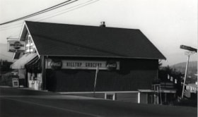
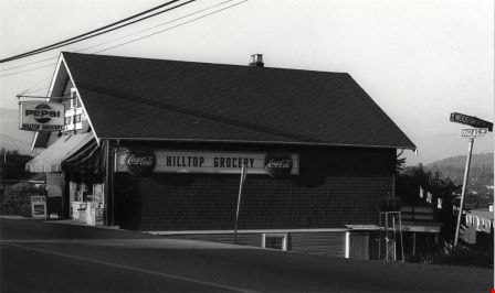
- Photograph shows Hilltop Grocery located at 3690 Douglas Road, near the corner of Douglas Road and Woodsworth Street. It was built in 1916.
- Repository
- City of Burnaby Archives
- Date
- October, 1976
- Collection/Fonds
- Burnaby Public Library Contemporary Visual Archive Project
- Physical Description
- 1 photograph : b&w ; 11 x 16 cm mounted on cardboard
- Description Level
- Item
- Record No.
- 556-163
- Access Restriction
- No restrictions
- Reproduction Restriction
- Reproduce for fair dealing purposes only
- Accession Number
- 2013-13
- Scope and Content
- Photograph shows Hilltop Grocery located at 3690 Douglas Road, near the corner of Douglas Road and Woodsworth Street. It was built in 1916.
- Names
- Hilltop Grocery
- Media Type
- Photograph
- Photographer
- Salmon, Stu
- Notes
- Scope note taken directly from BPL photograph description.
- 1 b&w copy negative : 10 x 12.5 cm accompanying
- Geographic Access
- Douglas Road
- Street Address
- 3690 Douglas Road
- Historic Neighbourhood
- Burnaby Lake (Historic Neighbourhood)
- Planning Study Area
- Douglas-Gilpin Area
Images
Douglas Road School gymnasium
https://search.heritageburnaby.ca/link/archivedescription38648
- Repository
- City of Burnaby Archives
- Date
- 1960
- Collection/Fonds
- Burnaby Historical Society fonds
- Description Level
- Item
- Physical Description
- 1 photograph : b&w ; 10 x 15 cm
- Scope and Content
- Photograph of two workmen (unidentified) standing next to a truckload of lumber outside the new Douglas Road School gymnasium.
- Repository
- City of Burnaby Archives
- Date
- 1960
- Collection/Fonds
- Burnaby Historical Society fonds
- Subseries
- Douglas Road School subseries
- Physical Description
- 1 photograph : b&w ; 10 x 15 cm
- Description Level
- Item
- Record No.
- 471-009
- Access Restriction
- No restrictions
- Reproduction Restriction
- Reproduce for fair dealing purposes only
- Accession Number
- BHS2005-3
- Scope and Content
- Photograph of two workmen (unidentified) standing next to a truckload of lumber outside the new Douglas Road School gymnasium.
- Names
- Douglas Road School
- Media Type
- Photograph
- Photographer
- Gordon, Ethel
- Notes
- Title based on contents of photograph.
- Geographic Access
- Douglas Road
- Canada Way
- Street Address
- 4861 Canada Way
- Historic Neighbourhood
- Burnaby Lake (Historic Neighbourhood)
- Planning Study Area
- Douglas-Gilpin Area
Images

![Aerial photograph of the Burnaby Village area, [1946] (date of original), copied 1991 thumbnail](/media/hpo/_Data/_Archives_Images/_Unrestricted/370/370-532.jpg?width=280)
Aerial photograph of the Burnaby Village area
https://search.heritageburnaby.ca/link/archivedescription37945
- Repository
- City of Burnaby Archives
- Date
- [1946] (date of original), copied 1991
- Collection/Fonds
- Burnaby Historical Society fonds
- Description Level
- Item
- Physical Description
- 1 photograph : b&w ; 3.5 x 4.4 cm print on contact sheet 20.5 x 26.7 cm
- Scope and Content
- Aerial photograph of the Sperling Avenue/Douglas Road Burnaby Village area.
- Repository
- City of Burnaby Archives
- Date
- [1946] (date of original), copied 1991
- Collection/Fonds
- Burnaby Historical Society fonds
- Subseries
- Burnaby Image Bank subseries
- Physical Description
- 1 photograph : b&w ; 3.5 x 4.4 cm print on contact sheet 20.5 x 26.7 cm
- Description Level
- Item
- Record No.
- 370-532
- Access Restriction
- No restrictions
- Reproduction Restriction
- No known restrictions
- Accession Number
- BHS1999-03
- Scope and Content
- Aerial photograph of the Sperling Avenue/Douglas Road Burnaby Village area.
- Subjects
- Aerial Photographs
- Media Type
- Photograph
- Notes
- Title based on contents of photograph
- 1 b&w copy negative accompanying
- Negative has a pink cast
- Geographic Access
- Douglas Road
- Sperling Avenue
- Canada Way
- Historic Neighbourhood
- Burnaby Lake (Historic Neighbourhood)
Images
![Aerial photograph of the Burnaby Village area, [1946] (date of original), copied 1991 thumbnail](/media/hpo/_Data/_Archives_Images/_Unrestricted/370/370-532.jpg)
![Suey Ying Jung (Laura) with produce baskets, [between 1940 and 1942] thumbnail](/media/hpo/_Data/_BVM_Images/2017/2017_0024_0026_001.jpg?width=280)
Suey Ying Jung (Laura) with produce baskets
https://search.heritageburnaby.ca/link/museumdescription4073
- Repository
- Burnaby Village Museum
- Date
- [between 1940 and 1942]
- Collection/Fonds
- Julie Lee and Cecil Lee family fonds
- Description Level
- Item
- Physical Description
- 1 photograph (tiff) : sepia ; 1000 dpi
- Scope and Content
- Photograph of Suey Ying Jung (Laura) wearing sunglasses and overalls, sitting in front of family home with produce baskets balanced on pole.
- Repository
- Burnaby Village Museum
- Collection/Fonds
- Julie Lee and Cecil Lee family fonds
- Description Level
- Item
- Physical Description
- 1 photograph (tiff) : sepia ; 1000 dpi
- Scope and Content
- Photograph of Suey Ying Jung (Laura) wearing sunglasses and overalls, sitting in front of family home with produce baskets balanced on pole.
- Names
- Jung, Suey Ying "Laura"
- Geographic Access
- Douglas Road
- Accession Code
- BV017.24.26
- Access Restriction
- No restrictions
- Reproduction Restriction
- No known restrictions
- Date
- [between 1940 and 1942]
- Media Type
- Photograph
- Historic Neighbourhood
- Burnaby Lake (Historic Neighbourhood)
- Planning Study Area
- Douglas-Gilpin Area
- Scan Resolution
- 1000
- Scan Date
- 01-Oct-2017
- Scale
- 100
- Notes
- Title based on contents of photograph
Images
![Suey Ying Jung (Laura) with produce baskets, [between 1940 and 1942] thumbnail](/media/hpo/_Data/_BVM_Images/2017/2017_0024_0026_001.jpg)
![Sperling Avenue and Douglas Road, [between 1938 and 1940] (date of original), copied 1991 thumbnail](/media/hpo/_Data/_Archives_Images/_Unrestricted/370/370-534.jpg?width=280)
Sperling Avenue and Douglas Road
https://search.heritageburnaby.ca/link/archivedescription37947
- Repository
- City of Burnaby Archives
- Date
- [between 1938 and 1940] (date of original), copied 1991
- Collection/Fonds
- Burnaby Historical Society fonds
- Description Level
- Item
- Physical Description
- 1 photograph : b&w ; 2.8 x 3.7 cm print on contact sheet 20.6 x 26.1 cm
- Scope and Content
- Photograph of Sperling Avenue and Douglas Road. World Bros. Hardware can be seen on the north side of Douglas Road, with the General Store across the street.There are four people on horseback. The photograph was taken from Sperling Avenue.
- Repository
- City of Burnaby Archives
- Date
- [between 1938 and 1940] (date of original), copied 1991
- Collection/Fonds
- Burnaby Historical Society fonds
- Subseries
- Burnaby Image Bank subseries
- Physical Description
- 1 photograph : b&w ; 2.8 x 3.7 cm print on contact sheet 20.6 x 26.1 cm
- Description Level
- Item
- Record No.
- 370-534
- Access Restriction
- No restrictions
- Reproduction Restriction
- No known restrictions
- Accession Number
- BHS1999-03
- Scope and Content
- Photograph of Sperling Avenue and Douglas Road. World Bros. Hardware can be seen on the north side of Douglas Road, with the General Store across the street.There are four people on horseback. The photograph was taken from Sperling Avenue.
- Names
- World Brothers Hardware
- Media Type
- Photograph
- Notes
- Title based on contents of photograph
- 1 b&w copy negative accompanying
- Geographic Access
- Sperling Avenue
- Douglas Road
- Historic Neighbourhood
- Burnaby Lake (Historic Neighbourhood)
- Planning Study Area
- Morley-Buckingham Area
Images
![Sperling Avenue and Douglas Road, [between 1938 and 1940] (date of original), copied 1991 thumbnail](/media/hpo/_Data/_Archives_Images/_Unrestricted/370/370-534.jpg)
![Aerial photograph of Douglas Road and Sperling Avenue, [1938] thumbnail](/media/hpo/_Data/_BVM_Images/1990/199200470001.jpg?width=280)
Aerial photograph of Douglas Road and Sperling Avenue
https://search.heritageburnaby.ca/link/museumdescription1165
- Repository
- Burnaby Village Museum
- Date
- [1938]
- Collection/Fonds
- Burnaby Village Museum Photograph collection
- Description Level
- Item
- Physical Description
- 1 photograph : b&w ; 19 x 24 cm
- Scope and Content
- Aerial photograph of the area surrounding Douglas Road and Sperling Avenue.
- Repository
- Burnaby Village Museum
- Collection/Fonds
- Burnaby Village Museum Photograph collection
- Description Level
- Item
- Physical Description
- 1 photograph : b&w ; 19 x 24 cm
- Scope and Content
- Aerial photograph of the area surrounding Douglas Road and Sperling Avenue.
- Subjects
- Aerial Photographs
- Geographic Access
- Douglas Road
- Sperling Avenue
- Accession Code
- BV992.47.1
- Access Restriction
- No restrictions
- Date
- [1938]
- Media Type
- Photograph
- Historic Neighbourhood
- Burnaby Lake (Historic Neighbourhood)
- Planning Study Area
- Morley-Buckingham Area
- Scan Resolution
- 600
- Scan Date
- 01-Jun-09
- Scale
- 100
- Notes
- Title based on contents of photograph
- Notes on verso of photograph read: "Burnaby Image Bank #532" and "DOUGLAS ROAD AND SPERLING c. 1938"
- Stamp on verso of photograph reads: "Copyright Simon Fraser/ University Archives"
Images
![Aerial photograph of Douglas Road and Sperling Avenue, [1938] thumbnail](/media/hpo/_Data/_BVM_Images/1990/199200470001.jpg)
![Sperling Avenue and Douglas Road, [1937 or 1938] (date of original), copied 1991 thumbnail](/media/hpo/_Data/_Archives_Images/_Unrestricted/370/370-537.jpg?width=280)
Sperling Avenue and Douglas Road
https://search.heritageburnaby.ca/link/archivedescription37950
- Repository
- City of Burnaby Archives
- Date
- [1937 or 1938] (date of original), copied 1991
- Collection/Fonds
- Burnaby Historical Society fonds
- Description Level
- Item
- Physical Description
- 1 photograph : b&w ; 2.7 x 3.8 cm print on contact sheet 20.6 x 26.1 cm
- Scope and Content
- Photograph of the Sperling Avenue and Douglas Road area.
- Repository
- City of Burnaby Archives
- Date
- [1937 or 1938] (date of original), copied 1991
- Collection/Fonds
- Burnaby Historical Society fonds
- Subseries
- Burnaby Image Bank subseries
- Physical Description
- 1 photograph : b&w ; 2.7 x 3.8 cm print on contact sheet 20.6 x 26.1 cm
- Description Level
- Item
- Record No.
- 370-537
- Access Restriction
- No restrictions
- Reproduction Restriction
- No known restrictions
- Accession Number
- BHS1999-03
- Scope and Content
- Photograph of the Sperling Avenue and Douglas Road area.
- Subjects
- Geographic Features - Fields
- Media Type
- Photograph
- Notes
- Title based on contents of photograph
- 1 b&w copy negative accompanying
- Geographic Access
- Douglas Road
- Sperling Avenue
- Canada Way
- Historic Neighbourhood
- Burnaby Lake (Historic Neighbourhood)
- Planning Study Area
- Morley-Buckingham Area
Images
![Sperling Avenue and Douglas Road, [1937 or 1938] (date of original), copied 1991 thumbnail](/media/hpo/_Data/_Archives_Images/_Unrestricted/370/370-537.jpg)
![Car Accident, [1937 or 1938] (date of original), copied 1991 thumbnail](/media/hpo/_Data/_Archives_Images/_Unrestricted/370/370-548.jpg?width=280)
Car Accident
https://search.heritageburnaby.ca/link/archivedescription37961
- Repository
- City of Burnaby Archives
- Date
- [1937 or 1938] (date of original), copied 1991
- Collection/Fonds
- Burnaby Historical Society fonds
- Description Level
- Item
- Physical Description
- 1 photograph : b&w ; 3.3 x 2.5 cm print on contact sheet 20.6 x 26.1 cm
- Scope and Content
- Photograph of a damaged car belonging to Bob Pontifex, after an accident at Sperling Avenue and Douglas Road.
- Repository
- City of Burnaby Archives
- Date
- [1937 or 1938] (date of original), copied 1991
- Collection/Fonds
- Burnaby Historical Society fonds
- Subseries
- Burnaby Image Bank subseries
- Physical Description
- 1 photograph : b&w ; 3.3 x 2.5 cm print on contact sheet 20.6 x 26.1 cm
- Description Level
- Item
- Record No.
- 370-548
- Access Restriction
- No restrictions
- Reproduction Restriction
- No known restrictions
- Accession Number
- BHS1999-03
- Scope and Content
- Photograph of a damaged car belonging to Bob Pontifex, after an accident at Sperling Avenue and Douglas Road.
- Subjects
- Accidents - Automobile Accidents
- Media Type
- Photograph
- Notes
- Title based on contents of photograph
- 1 b&w copy negative accompanying
- Geographic Access
- Douglas Road
- Sperling Avenue
- Canada Way
- Historic Neighbourhood
- Burnaby Lake (Historic Neighbourhood)
Images
![Car Accident, [1937 or 1938] (date of original), copied 1991 thumbnail](/media/hpo/_Data/_Archives_Images/_Unrestricted/370/370-548.jpg)
![Still Creek Bridge, [1930] (date of original), copied 1986 thumbnail](/media/hpo/_Data/_Archives_Images/_Unrestricted/126/160-004.jpg?width=280)
Still Creek Bridge
https://search.heritageburnaby.ca/link/archivedescription34925
- Repository
- City of Burnaby Archives
- Date
- [1930] (date of original), copied 1986
- Collection/Fonds
- Burnaby Historical Society fonds
- Description Level
- Item
- Physical Description
- 1 photograph : b&w ; 12.4 x 8.7 cm print
- Scope and Content
- Photograph of five boys with bullrushes on the Still Creek Bridge, Douglas Road.
- Repository
- City of Burnaby Archives
- Date
- [1930] (date of original), copied 1986
- Collection/Fonds
- Burnaby Historical Society fonds
- Subseries
- Bernard Bellinger subseries
- Physical Description
- 1 photograph : b&w ; 12.4 x 8.7 cm print
- Description Level
- Item
- Record No.
- 160-004
- Access Restriction
- No restrictions
- Reproduction Restriction
- No known restrictions
- Accession Number
- BHS1986-10
- Scope and Content
- Photograph of five boys with bullrushes on the Still Creek Bridge, Douglas Road.
- Subjects
- Structures - Bridges
- Media Type
- Photograph
- Notes
- Title based on contents of photograph
- Geographic Access
- Douglas Road
- Still Creek Avenue
- Historic Neighbourhood
- Burnaby Lake (Historic Neighbourhood)
- Planning Study Area
- Dawson-Delta Area
- Ardingley-Sprott Area
Images
![Still Creek Bridge, [1930] (date of original), copied 1986 thumbnail](/media/hpo/_Data/_Archives_Images/_Unrestricted/126/160-004.jpg)
![McWilliams house, [193-] thumbnail](/media/hpo/_Data/_BVM_Images/1990/199400220003.jpg?width=280)
McWilliams house
https://search.heritageburnaby.ca/link/museumdescription1196
- Repository
- Burnaby Village Museum
- Date
- [193-]
- Collection/Fonds
- E.W. Bateman family fonds
- Description Level
- Item
- Physical Description
- 1 photograph : sepia ; 6.5 x 12 cm
- Scope and Content
- Photograph of the McWilliams house on Douglas Road. Mamie Bateman McWilliams lived here with her family and is the daughter of Edwin Wettenhall Bateman, who built Elworth (directly across the street).
- Repository
- Burnaby Village Museum
- Collection/Fonds
- E.W. Bateman family fonds
- Description Level
- Item
- Physical Description
- 1 photograph : sepia ; 6.5 x 12 cm
- Scope and Content
- Photograph of the McWilliams house on Douglas Road. Mamie Bateman McWilliams lived here with her family and is the daughter of Edwin Wettenhall Bateman, who built Elworth (directly across the street).
- Subjects
- Buildings - Residential - Houses
- Geographic Access
- Douglas Road
- Accession Code
- BV994.22.3
- Access Restriction
- No restrictions
- Reproduction Restriction
- No known restrictions
- Date
- [193-]
- Media Type
- Photograph
- Historic Neighbourhood
- Burnaby Lake (Historic Neighbourhood)
- Planning Study Area
- Morley-Buckingham Area
- Scan Resolution
- 600
- Scan Date
- 2024-04-23
- Notes
- Title based on contents of photograph
- Stamp on verso of photograph reads: "Better Pictures/ NuGloss/ PHOTO FINISH/ Vancouver Drug Co."
Images
![McWilliams house, [193-] thumbnail](/media/hpo/_Data/_BVM_Images/1990/199400220003.jpg)
![McWilliams house, [193-] thumbnail](/media/hpo/_Data/_BVM_Images/1990/199400220001.jpg?width=280)
McWilliams house
https://search.heritageburnaby.ca/link/museumdescription3127
- Repository
- Burnaby Village Museum
- Date
- [193-]
- Collection/Fonds
- E.W. Bateman family fonds
- Description Level
- Item
- Physical Description
- 1 photograph : b&w ; 5 x 8 cm
- Scope and Content
- Photograph of the McWilliams house on Douglas Road. The house has a large patio area with a gravel road in front and a wood fence behind. A boy is sitting with a dog on the front steps. Mamie Bateman McWilliams lived here with her family, and is the daughter of Edwin Wettenhall Bateman, who built E…
- Repository
- Burnaby Village Museum
- Collection/Fonds
- E.W. Bateman family fonds
- Description Level
- Item
- Physical Description
- 1 photograph : b&w ; 5 x 8 cm
- Scope and Content
- Photograph of the McWilliams house on Douglas Road. The house has a large patio area with a gravel road in front and a wood fence behind. A boy is sitting with a dog on the front steps. Mamie Bateman McWilliams lived here with her family, and is the daughter of Edwin Wettenhall Bateman, who built Elworth (directly across the street).
- Subjects
- Buildings - Residential - Houses
- Geographic Access
- Douglas Road
- Accession Code
- BV994.22.1
- Access Restriction
- No restrictions
- Reproduction Restriction
- No known restrictions
- Date
- [193-]
- Media Type
- Photograph
- Historic Neighbourhood
- Burnaby Lake (Historic Neighbourhood)
- Planning Study Area
- Morley-Buckingham Area
- Scan Resolution
- 600
- Scan Date
- 2024-04-23
- Notes
- Title based on contents of photograph
Images
![McWilliams house, [193-] thumbnail](/media/hpo/_Data/_BVM_Images/1990/199400220001.jpg)
![McWilliams house, [193-] thumbnail](/media/hpo/_Data/_BVM_Images/1990/199400220002.jpg?width=280)
McWilliams house
https://search.heritageburnaby.ca/link/museumdescription3128
- Repository
- Burnaby Village Museum
- Date
- [193-]
- Collection/Fonds
- E.W. Bateman family fonds
- Description Level
- Item
- Physical Description
- 1 photograph : b&w ; 6 x 10.5 cm
- Scope and Content
- Photograph of the McWilliams house on Douglas Road. Mamie Bateman McWilliams lived here with her family and is the daughter of Edwin Wettenhall Bateman, who built Elworth (directly across the street).
- Repository
- Burnaby Village Museum
- Collection/Fonds
- E.W. Bateman family fonds
- Description Level
- Item
- Physical Description
- 1 photograph : b&w ; 6 x 10.5 cm
- Scope and Content
- Photograph of the McWilliams house on Douglas Road. Mamie Bateman McWilliams lived here with her family and is the daughter of Edwin Wettenhall Bateman, who built Elworth (directly across the street).
- Subjects
- Buildings - Residential - Houses
- Geographic Access
- Douglas Road
- Accession Code
- BV994.22.2
- Access Restriction
- No restrictions
- Reproduction Restriction
- No known restrictions
- Date
- [193-]
- Media Type
- Photograph
- Historic Neighbourhood
- Burnaby Lake (Historic Neighbourhood)
- Planning Study Area
- Morley-Buckingham Area
- Scan Resolution
- 600
- Scan Date
- 2024-04-23
- Notes
- Title based on contents of photograph
Images
![McWilliams house, [193-] thumbnail](/media/hpo/_Data/_BVM_Images/1990/199400220002.jpg)

Land being cleared for Saint Theresa's Roman Catholic Church
https://search.heritageburnaby.ca/link/museumdescription902
- Repository
- Burnaby Village Museum
- Date
- 1929
- Collection/Fonds
- Burnaby Village Museum Photograph collection
- Description Level
- Item
- Physical Description
- 1 photograph : b&w ; 6.7 x 11.4 cm
- Scope and Content
- Photograph of three unidentified men standing on Douglas Road (later renamed in part Canada Way) with Laurel Street in the background on the left and the site of Saint Theresa's Roman Catholic Church as a lot with blackened stumps. The church was located at the southeast corner of Canada Way and L…
- Repository
- Burnaby Village Museum
- Collection/Fonds
- Burnaby Village Museum Photograph collection
- Description Level
- Item
- Physical Description
- 1 photograph : b&w ; 6.7 x 11.4 cm
- Scope and Content
- Photograph of three unidentified men standing on Douglas Road (later renamed in part Canada Way) with Laurel Street in the background on the left and the site of Saint Theresa's Roman Catholic Church as a lot with blackened stumps. The church was located at the southeast corner of Canada Way and Laurel Street. According to an accompanying note located with the photograph, the first church building burned to the ground the night before it was to be blessed. Insurance for the church had been arranged for by Colonel Dorrell only hours before it was burned and even though signatures had not been affixed to the policy, the insurance company honoured the claim. The second building was smaller and had no basement. Father Trainer was the first priest. This church was torn down in 1974 and a new church building was erected across the road on Canada Way.
- Subjects
- Land Clearing
- Geographic Access
- Douglas Road
- Canada Way
- Laurel Street
- Accession Code
- HV975.105.1
- Access Restriction
- No restrictions
- Reproduction Restriction
- No known restrictions
- Date
- 1929
- Media Type
- Photograph
- Historic Neighbourhood
- Burnaby Lake (Historic Neighbourhood)
- Planning Study Area
- Douglas-Gilpin Area
- Scan Resolution
- 600
- Scan Date
- 2023-06-06
- Notes
- Title based on contents of photograph
- Information on the scope and content of the photograph is taken from an acquisition record from the time of the accession
Images


Construction of Saint Theresa's Roman Catholic Church
https://search.heritageburnaby.ca/link/museumdescription903
- Repository
- Burnaby Village Museum
- Date
- March 19, 1929
- Collection/Fonds
- Burnaby Village Museum Photograph collection
- Description Level
- Item
- Physical Description
- 1 photograph : sepia ; 6.9 x 11.5 cm
- Scope and Content
- Photograph of Douglas Road (later renamed in part Canada Way) with Laurel Street in the background on the left and the site of Saint Theresa's Roman Catholic Church as a lot with blackened stumps. The church was located at the southeast corner of Canada Way and Laurel Street. The photograph is ta…
- Repository
- Burnaby Village Museum
- Collection/Fonds
- Burnaby Village Museum Photograph collection
- Description Level
- Item
- Physical Description
- 1 photograph : sepia ; 6.9 x 11.5 cm
- Scope and Content
- Photograph of Douglas Road (later renamed in part Canada Way) with Laurel Street in the background on the left and the site of Saint Theresa's Roman Catholic Church as a lot with blackened stumps. The church was located at the southeast corner of Canada Way and Laurel Street. The photograph is taken from the same angle as HV975.105.1. There is a freight wagon loaded with lumber, pulled by two horses on Douglas Road. An annotation on the back of the photo reads, "March 19th 1929 / The first load of lumber taken for the construction of St St [sic] Therese [sic] Church on the Grandview Highway / Burnaby BC."
- Geographic Access
- Douglas Road
- Canada Way
- Laurel Street
- Accession Code
- HV975.105.2
- Access Restriction
- No restrictions
- Reproduction Restriction
- No known restrictions
- Date
- March 19, 1929
- Media Type
- Photograph
- Historic Neighbourhood
- Burnaby Lake (Historic Neighbourhood)
- Planning Study Area
- Douglas-Gilpin Area
- Scan Resolution
- 600
- Scan Date
- 2023-06-13
- Notes
- Title based on contents of photograph
- Information on the scope and content of the photograph is taken from an acquisition record from the time of the accession
Images
